

Includes Historic Babylon Trail
This is a 6-mile loop with 1000 vertical feet of climbing, located just east of Leeds (about 10 miles north of St. George). The loop is best done counterclockwise, with a climb on the Historic Babylon Trail and a technical descent on Little Purgatory.
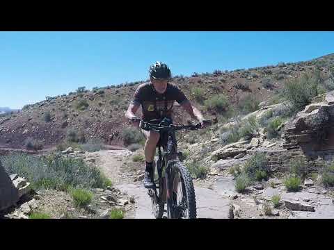
The descent has a mile of tricky rock that requires advanced tech skills. The trail is constant slam-bang rock. Off-camber, facing ledges, dropping ledges, and major boulders.


The ride starts from the bottom of Grapevine Wash. Immediately, you'll join the creek as it cuts through the rock of East Reef.
Within the first 1/3 mile, you'll do several creek crossings. Riding in January, we found about 8 inches of flowing water and some very sticky mud on the creek banks. But it was possible to ride right through. The creek might be dry later in the year.


The first trail fork is the East Reef trail at mile 0.2. Turn hard to the right. The next fork (mile 0.3) is where Little Purgatory joins. Keep to the right. And the final fork is the alternate-entry trail at mile 0.4. fork left to drop through the creek.


I'd recommend this loop only for strong and experienced technical riders. The loop is pretty quick, so it makes a good late afternoon "on the way into town" ride. I'd rate it both more technical and more strenuous than Zen, which some of the riding resembles. But I'd rank it just below Zen in overall fun factor.


0.0 Step over at gate and ride toward sandstone slot
N37 12.116 W113 20.930
Petroglyphs high on your L on the sandstone
Several creek crossings
0.4 Keep straight (R) on Historic Babylon N37 12.330 W113 20.958
0.5 Keep L as alternate TH path joins
1.8 Tough climb up canyon
2.3 Fence, left uphill
3.5 Summit, descend on Little Babylon
4.1 Tech stuff
5.4 At fork, L to trailhead
5.8 Back at TH
The dirt road to Little Purgatory has soft sandy sections. A car with four-wheel drive capability and reasonable clearance is recommended. As with other dirt roads in the area, please don't go when it's muddy!
Note that the Leeds/Silver Reef I-15 exit is split in two, with each part 1.7 miles away on opposite ends of the town of Leeds. Southbound OFF and northbound ON are located north of Leeds. Northbound OFF and southbound ON are south of Leeds.
Northbound from St. George, take the Leeds/Silver Reef exit. Drive north 1.7 miles through Leeds and continue north on the frontage road as you pass the freeway on-ramp. Southbound on I-15, take the Leeds/Silver Reef exit and turn left under the freeway, then left on the frontage road. From the northern I-15 access, drive north on the frontage road (east of the freeway) for 0.7 miles. Now turn right on the road signed for Little Babylon and Sand Cove. It will turn to dirt. Pass the Sand Cove parking area (on your left) at mile 3. Pass the alternate trailhead on your right at mile 3.5. After descending down a wash, park at the Little Babylon trailhead, 4 miles from the freeway access road. (There's not much parking at Historic Babylon. Maybe 3-4 cars. If you don't find a spot, don't "make your own." Drive back to the Sand Cove trailhead then pedal the road to the trail!)

Single-page riding guide: View
GPS track files (right-click and "Save as..."):
GPX
Topo map for printing (500K): View
Lodging, camping, shops: Links to St. George area resources
Water: bring your own
Camping: Sand Cove
Bike services: St. George


