

Red Mesa Rim
The Red Mesa Rim trail system opened in 2023. It's found on Red Mesa right on the edge of Page, Arizona, just across the state line from Utah. The trail system is rather complex, with frequent trail forks stuffed into an area less than a square mile. The elevation is around 4000 feet and the ride is fully sun-exposed, for an expected riding season of March through December.
The trail system is designed to please a wide variety of users. The riding varies from easy and short to long and technical. There's a trail map at the trailhead and carsonite posts at all trail forks, but the choices may seem overwhelming on your first trip. It's easy to have no idea where you are, so a navigation system is highly recommended. Beginners should do a bit of pre-ride planning.

, Mushroom Rock (ahead), and Eastern Ledge (left) shows the painting scheme.")
Trails are two-way, and are marked with paint spots and arrows on the rock. Easy trails are marked in green, intermediate in blue, and expert in black. Some cliffside expert trail segments are marked with red paint.
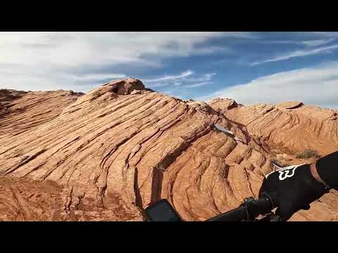
The riding is fun and visually striking. There are wide views from every point of the trail system.
Trailhead

The Red Mesa Rim trailhead is located at the top of Red Mesa, reached via a quarter-mile gravel road from Route 20 on the southern edge of Page. The parking area is huge, with room for around 100 vehicles.
The Red Mesa Loop trail exits the parking area right alongside the entry road (clockwise ride) or from the eastern side of the parking lot just northeast of the bathroom (counterclockwise ride). This two-mile easy loop is the key to reaching all other riding options in the trail system.
Main Trail - Red Mesa Loop - Easier

The Red Mesa Loop starts and ends on opposite sides of the trailhead. It can be done either direction, although mileage markers are set for a clockwise ride. The loop is 2.0 miles around. There's an optional easy eastern loop off Red Mesa Loop that adds two miles (see below).
The main loop is mostly dirt with some areas of open rock and lots of rock roll-overs. It's a very quick ride, and I'd suggest that you cruise around once when you first arrive to get familiar with the trail forks and the general layout of the riding area. There are at least 10 trail forks off the main loop for other loops and tech side-rides. To stay on the Red Mesa Loop, always keep to the right if you're going clockwise; to the left if you're riding counterclockwise.

Tech alternates off Red Mesa Loop

In addition to trail forks for the other loops and riding options -- see below -- the Red Mesa Loop offers four technical side alternates. While paint-striped blue, the final two of the four are expert-level rides because of the rough rock and cliff exposures. My impression is that these tech alternates are slightly easier when done in the clockwise direction.
When riding clockwise, the alternate lines are found at:
0.3 miles, length 0.1 mile
0.4 miles, length 0.1 mile
0.7 miles, length 0.2 mile
(Northern Runway to Hives and Hoodoos at mile 0.9)
1.1 miles, length 0.1 mile
All of these side-routes are on the (downhill) side of the trail, marked by carsonite
posts. None of them are named, as far as I know.

East Loop (Easy Rider, Eastern Ledge, Sandy Bailout) - Easier
. This view is looking west, as though riding counterclockwise.")
The East Loop is part of the four-mile easy ride (including the Red Mesa Loop) indicated by the trail markers, but is significantly harder to navigate. It's found on the east side of Red Mesa Loop and circles a projection of the mesa. From the northern (uphill side, first encountered when riding clockwise on Red Mesa Loop) side, it consists of Easy Rider (a wide dirt trail), an easier section of the Eastern Ledge trail, and Sandy Bailout, another easy dirt trail.
Easy Rider is 0.7 miles in length. At the eastern side, it curves around downhill to join Eastern Ledge. The short section of the Eastern Ledge trail that's used by the East Loop is easy to ride, although there's some open rock riding and nearby cliffs. After 0.5 miles, keep right onto Sandy Bailout, which will take you back west to the main Red Mesa Loop after 0.4 miles.

Tech options off the East Loop

Running right alongside the Easy Rider dirt path is the highly technical Fin Rock Ledge trail. It bangs along the top of a fin of protruding rock along the northern mesa edge. The trail is 0.4 miles long and is marked with red paint stripes. On the west end it forks from Easy Rider just downhill from the Red Mesa Loop. On the east, it's a continuation of the Eastern Ledge trail when riding counterclockwise.
At the northeast corner of the Eastern Ledge trail, there's a technical alternate line called Cuddy Corner, named after the trailbuilder. This route descends a bit off the shoulder of the mesa top before returning 1/4 mile later. It's marked with red paint.

Hives and Hoodoos Loop (plus Northern Runway)
 and black diamond (to Hives and Hoodoos).")
The Hives and Hoodoos loop is an expert-level lariat ride that forks north from Easy Rider just downhill from the main Red Mesa Loop on the eastern side. It's a bit over 0.1 miles to the fork of the lariat, then the loop is 2 miles around. When doing the ride clockwise (a left turn as you reach the loop), keep right at the fork with Northern Runway at mile 0.3. You'll reach a short alternate line at mile 0.5 from the Red Mesa Loop.
There's a small optional tech loop called Eagle Rock Loop at mile 1.4. It's around 0.2 miles in length (I've included that distance in the mileage and the track for Hives and Hoodoos.)
Northern Runway can be either an alternate entry to the Hives and Hoodoos loop, or it can be combined with only the western side of Hives and Hoodoos as a short loop. See the map. Shortly after leaving the Red Mesa Loop (at mile 0.9 riding clockwise) it descends a slickrock ski slope, then contours the mesa's edge as it curves around to the south before ending on the Hives and Hoodoos loop. For the full loop, turn left. For the short trip back up, fork right, then right again when you reach the stem of the lariat.

Mushroom Rock Loop

The Mushroom Rock Loop begins and ends on the Sandy Bailout trail, reached by forking east from the main Red Mesa Loop. The western entry to the loop -- located just 0.1 miles from Red Mesa Loop -- is a downhill of sandy dirt and looks like something you don't want to ride. But you'll soon reach a wide expanse of slickrock where the mesa's skirts meet the valley.
The eastern side of the Mushroom Rock loop starts at a three-way with Sandy Bailout and Eastern Ledge. Mushroom Rock is 1.4 miles long, running out and back on the lower skirt of the mesa below the eastern side of the Red Mesa Loop.


Getting there:
On US-89, cross the bridge over the Colorado and follow the highway as it
turns south past Page. Keep straight at the roundabout. At the light at
Highway 98, turn left. Drive around 2 miles and turn to the right
southbound on Route 20. One-half mile later, turn left onto a gravel road
at the Red Mesa sign and drive up to the trailhead.
Bathroom: at trailhead
Water: none
Camping: Wahweep Marina, various commercial campgounds around Page.


