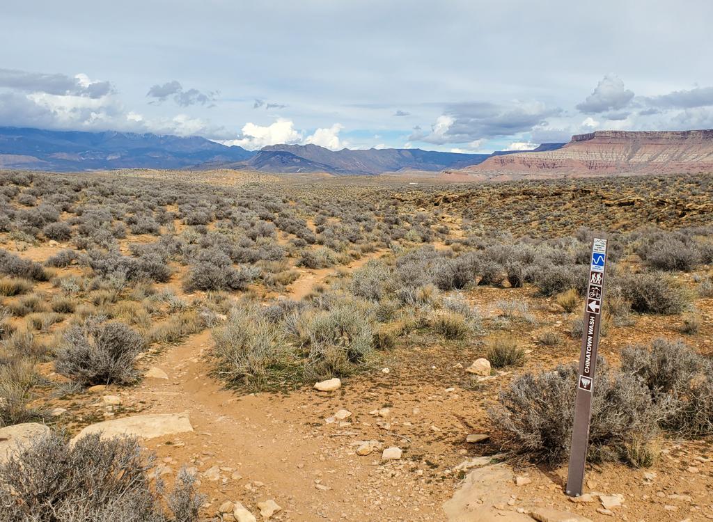


The Revenant trails are located on BLM land two miles west of the summit of Utah Hill. This is around 25 miles from downtown St George. At an average elevation of 4500 feet, the expected riding season will be March through December.
The trails are divided into an eastern and a western zone, each its own unique climbing trail and three DH trails. The Hell Hole DH trail ends at the top of the eastern zone of Revenant, but will be discussed on a separate trail page. See the information below in the map section.
The single climbing route for the trails west of parking is Rally. You'll find it at the uphill end of the parking zone. The three downhill trails on the west side are (1) Bullwinkle, suitable for beginning riders, (2) Ninja, which functions as both an intermediate and expert trail depending on which line you pick for your tires, and (3) Rock House, a double-expert line. Connections between the middle of the downhill trails let you mix your ride.


Trailhead

Drive west from St George on Old 91. Keep left at the Gunlock turnoff and climb Utah Hill. Two miles after crossing the summit, look for mile marker 7 on your left. The dirt road turnoff is on your right, just past the mile marker. Drive 0.4 miles and turn left into the primitive parking area. Low-clearance sedans should park at the highway and pedal to the trailhead. The uphill trail is at the north (uphill) end of the parking area. It will cross to the right side of the entry doubletrack.
There's a plan to install a toilet and improve the road and parking, but this must wait for funding.
West-side trail group
Rally (climbing trail)

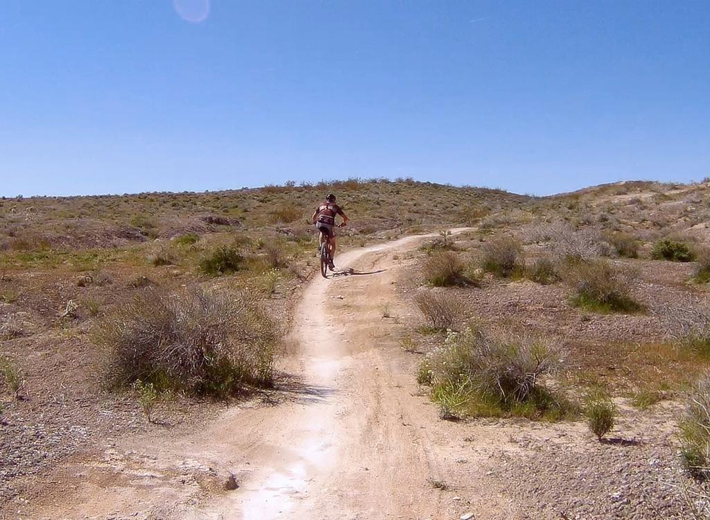
The Rally trail is the route uphill for the trails on the west side. It's 0.7 miles in length, gaining 250 vertical feet in elevation. The climbing trail is narrow hand-made singletrack with a steady but gentle rate of climb. You'll follow the edge of the wash as you head up the valley.
At the top, Rally connects to Bullwinkle -- with all the west-side DH routes starting on the same trail.
Bullwinkle (easy downhill trail)

To descend the easier downhill trail Bullwinkle, simply keep to the left at all trail forks as you head down. Like all the downhill options, Bullwinkle is highly engineered with a wide riding surface. Roller bumps keep things interesting between the highly-banked turns.
At 400 feet down Bullwinkle there's a trail fork for both the intermediate and double-expert routes. Keep to the left.
The next fork is an optional crossover. You can veer right to exit Bullwinkle and descend Ninja. Riders from Ninja may be entering Bullwinkle at this point.


From top back to trailhead, Bullwinkle is 0.9 miles long. The trail joins a common return trail just downhill from the trailhead, and you'll climb 0.1 miles of doubletrack to get back to the uphill singletrack. The full beginner loop will be 1.7 miles with 400 vertical feet of climbing.
Ninja (intermediate/expert downhill trail)

The Ninja trail forks away from Bullwinkle after 400 feet. This is also a downhill-only highly-engineered flow trail. Its course falls between Bullwinkle and Rock House. Around 100 feet after forking away form Bullwinkle, keep left to stay on Bullwinkle as Rock House takes the higher line to your right.
To descend Ninja, it will be a total of 0.9 miles from Rally back to the trailhead, with 350 vertical feet of descending. The turns on Ninja are tighter with steeper berms.
Ninja functions as both an intermediate and an expert-level trail. Most of the bumps have a line for intermediate-riders and a second expert-level option adjacent.


Ninja will touch on both Bullwinkle and Rock House during the descent, so you can swap trails in the middle.
Like the other west-side trails, Ninja extends down below the parking area to end on the common return trail. A full up-and-down loop will be 1.7 miles.
Rock House (double-black downhill trail)

Rockhouse is a double-black (high expert) trail. You should be comfortable with dirt jumps, as not all features have ride-arounds. On many areas, there's either a scouting path alongside the stunts, or an alternate stunt that's less tricky.
Rock House forks away from Ninja around 100 feet after the combined trail leaves Bullwinkle. Veer to the right for Rock House.
There will be spots where the trail splits into A/B options and mellow ride-arounds. This is a good spot to let the speedster behind you get by. I counted 5 separate lines at the downhill end of Rock House as it turns east to cross the wash.


At the bottom, Rock House has a last gasp of technical stunts -- including a gnarly gap jump over the wash -- before it turns east and collects traffic from Ninja and Bullwinkle. The combined trail ends on the doubletrack below the parking area.
East-side trail group
Time Warp (climbing trail)

The trail arriving on your right as you reach the top of Time Warp is the bottom of the Hell Hole DH trail. Turn hard left to Quickdraw and do NOT turn onto Hell Hole.

Quickdraw (easier descending trail)

Quickdraw has tight, highly banked turns. There are some rollers but no engineered jumps.


Quick info on Hell Hole DH: The Hell Hole DH begins just off the Hell Hole Pass road on Utah hill. This one-way downhill route lies on the south-facing slope beginning at 5750 feet elevation. Hell Hole is discussed in detail on another page.
Hell Hole is 4.6 miles in length, descending 1200 vertical feet. It ends at the top of the eastern set of trails in the Revenant system. (Here you pick from three one-way downhill trails to continue the descent.) This lengthens your downhill to between 5.3 and 5.5 miles (depending on which DH trail you picked when you arrived at Revenant). The total drop will be 1400 feet.
Most riders will shuttle this ride. But it's possible to ride it as a loop. From the Revenant system, exit to Old Highway 91. Climb 2.9 miles over the top of Utah Hill, then grind up three miles of the gravel Hell Hole Pass road. The full loop is 11.5 miles.
Hell Hole trailhead: Drive up Utah Hill on Old Highway 91 as above. Watch for mile marker 4, around 1/2 mile before you reach the summit. At mile 4.1 from the Gunlock turnoff, there will be a gravel road on your right. Drive 3 miles uphill on the road, then as the road turns right, spot the primitive parking area on your left. The doubletrack on the uphill side of parking is Hell Hole.

Getting there: Drive west from St George on Old 91 (the continuation of Sunset through Santa Clara and Ivins). Keep left at the Gunlock turnoff and climb Utah Hill on Old 91. Two miles after crossing the summit, look for mile marker 7 on your left. The dirt road turnoff is on your right, just past the mile marker. Drive 0.4 miles and turn left into the primitive parking area. Low-clearance sedans should park at the highway and pedal to the trailhead. The uphill trail is at the north (uphill) end of the parking area. It will cross to the right side of the entry doubletrack.