

Zephyr Trail
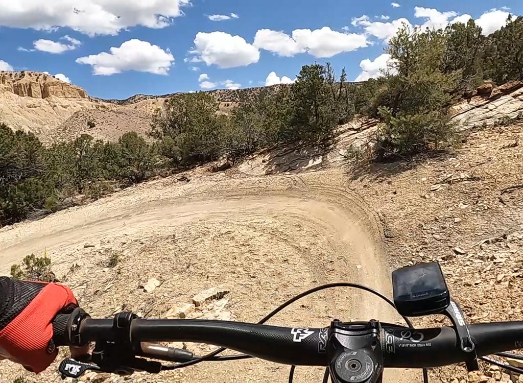
The Zephyr Trail offers a dirt-and-rock connection between the Brand Trails and the south Klonzo trails (and, thereby, on to north Klonzo ). The riding is easy (although two sandy washes may challenge your pedaling). The ride is very scenic with long views of cliffs, mountains, chasms and rolling rock.
Reasons to ride Zephyr!
(1) You can use it for a long day of auto-less highway-less pedaling,
going directly from Moab via the Old 191 trail to Zephyr then Klonzo.
(2) It can be your "back to town" route after the
significant-others drop you and your fellow cycling warriors off at Klonzo.
(3) After a big rainstorm, you can park at the Brand Trails and ride to
Klonzo when Willow Springs road is impassible.
(4) The southern half of Zephyr is also a reasonable stand-alone
out-and-back ride for beginners (after you hike through that first wash).
The Zephyr Trail itself is 4 miles long, but you have to ride your bike to it. It's about two miles from parking lot to trail at either end. (It's legal to drive your car northbound on the gravel Bar M, which is actually the old abandoned highway. Go through a gate -- close it after you -- and find a spot to park where the doubletrack turns to the right.)


There's little altitude change on the trail. The north end is about 100 feet lower in altitude than the south, but you'll add 100 vertical feet of climbing as you pass through Courthouse Wash. But except for the wall of the wash itself (which may be a short hike if the riding surface is loose), it's a very gradual slope.
At the south end, Zephyr starts at the north-northeast corner of the Bar M loop. From the main parking area, pedal east (straight in the direction you were driving as you entered the parking lot). Keep straight as you pass North 40 and Lazy-EZ. When you hit the Bar M Loop, go left. Stay straight on Bar M as you pass the fork to Circle O and the North 40 connector.


The next fork is cliff-side singletrack vs main Bar M. Go either way. (Beginners are encouraged NOT to take the cliff-side trail. It's a bit spooky.) As the trails rejoin just west of the chasm, find the trail sign for Zephyr on your right.
Immediately, you're presented with a broad sandy wash. This is Seven Mile Wash before it cuts into the Entrada sandstone below you. Look across and see the white paint spot on the sandstone. That's your target. Sandbars will change with every storm, so you may be able to pedal across cleanly, or you may hike.


On the east side of the wash, doubletrack awaits. The southern 3.2 miles is old jeep road. It's about 30% rock and 70% firm dirt.
You're east of the Moab fault here, so the Entrada sandstone you're riding on lies 1000 feet higher (and out of sight above the cliffs) west of the highway. The doubletrack skirts a layer of red shale with chunks of agate eroding out of it. (Do not harvest rocks. It's against the law.)
The easy pedaling lets you take in the scenery. To the south are cliffs of the Moab fault. To the southeast, the La Sal Mountains loom over rolling sandstone that plunges into Seven Mile Wash.
Entrada sandstone spires within Arches National Park are seen in the distance to the east. Back to the west, skirts of Chinle formation shales lead to Wingate sandstone cliffs.


The first fence is the border of Arches National Park. Because this old jeep path is classified as a "designated roadway," you're allowed to pedal your bike on rock and dirt within a national park. Cool, huh?
At the second fence, you'll leave the park. Good turn-around spot for beginners.
Go through the gate, then drop down and across Courthouse Wash. Continue uphill in the wash-bottom about 200 feet, then turn right to find singletrack climbing up and out of the wash.


This singletrack is (as of November 2014) a sea of soft slop. But I was able to crank through it both directions, no problem. Northbound takes a bit more leg because it's slightly uphill. After 0.8 miles of this singletrack, you'll find yourself on the southern end of the Midway Trail of Klonzo.
Southbound from Klonzo: From your car, the quickest route to the north end of Zephyr is via the Midway trailhead (see the driving directions). Just stay on Midway southbound until you hit Zephyr. From the main (Dunestone) trailhead, take The Edge to Midway.
If you're on the north trails, head for Zoltar. Then at the Redhot/Houdini trailhead, either take the 4x4 connector through Carousel to Midway, or rocket one-way down Redhot and Roller Coaster. The fork to Zephyr is just a little bit down Midway from the end of Roller Coaster.

About the sample ride...
This is a tour that will take you from the
Brand
Trails
to the top of
northern Klonzo
and back,
hitting some of the more interesting stuff along the way. It's 25 miles,
but
it's not as much work as it sounds. Your climbing will total only 2300
vertical feet. I did this ride in less than 4 hours, and I was stopping
to
take pictures. Goodies will include the new Houdini and Zoltar slickrock,
the radical
Gravitron
one-way trail, a side trip on VertiGo, then on to
southern
Klonzo
for the combined one-way Redhot and Roller Coaster trails, and
North
40
on the way back. Print the topos for Klonzo and the Brand system if
you want (links below), but there are maps at every trail intersection.
Awesome riding.
0.0 East from Brand parking N38 39.113 W109 40.103
0.1 Keep straight (L = N40, R = Lazy-EZ)
N38 39.207 W109 39.999
0.6 Fork L on Bar M N38 39.480 W109 39.713
0.8 Straight on Bar M (L=to N40, R=Circle O)
N38 39.645 W109 39.863
1.6 R to cliff-side singletrack N38 39.953 W109 40.480
2.0 R on Zephyr, cross wash to DT
N38 40.158 W109 40.813
3.6 Park border, through gate
5.2 Park border gate, cross wash
150 ft up wash, exit on ST to R
N38 41.237 W109 39.233
5.9 R to join DT
5.95 L on ST N38 41.649 W109 38.860
Keep R on Midway N38 41.668 W109 38.866
6.0 R across wash, then R toward Carousel
N38 41.695 W109 38.867
6.1 L on Carousel N38 41.721 W109 38.791
6.2 Keep R on Carousel N38 41.764 W109 38.748
(Dino tracks on L)
6.4 Parking, L on white-slash 4x4
N38 41.823 W109 38.639
6.6 R on Houdini N38 41.966 W109 38.483
8.3 Straight across road to Zoltar
N38 42.076 W109 38.239
9.3 R to stay on Borderline N38 42.758 W109 38.489
9.7 R on Wahoo N38 43.065 W109 38.422
10.0 R on Gravitron N38 43.168 W109 38.371
12.0 L on VertiGo N38 42.768 W109 39.124
(option: skip out-and-back, lose 1 mile)
12.5 Cross Canyon, turn back N38 42.816 W109 38.781
13.0 Keep L (previous Gravitron fork)
13.6 R on Secret Passage N38 42.621 W109 38.961
13.9 L on Cross Canyon N38 42.511 W109 38.761
14.1 Cross to Zoltar N38 42.524 W109 38.554
14.8 R to Redhot (white/red slashes)
N38 42.076 W109 38.239
200 ft, to Redhot ST
15.1 Houdini joins, then keep L on Redhot
N38 41.967 W109 38.542
15.4 5-way, cross to Roller Coaster
N38 41.917 W109 38.747
16.0 Join Midway N38 41.691 W109 38.875
16.1 Fork L on Zephyr N38 41.670 W109 38.867
20.0 L on Bar M N38 40.156 W109 40.811
21.2 R toward North 40 N38 39.647 W109 39.863
21.3 Keep R, then R again on North 40
N38 39.570 W109 39.982
24.8 Keep R N38 39.270 W109 40.016
24.9 R downhill N38 39.199 W109 39.995
25.0 Back at parking

Begin pedaling. You have three immediate options. (See the Brand Trails page for other options in the Brand system.)
Fastest but boring: Backtrack the way you came in, then keep pedaling north on the gravel road, which becomes the Bar M. Follow it downhill, then to the right (east). When Bar M is about to turn south (right) past the deep canyon, find Zephyr and fork left (east).
Recommended: Head east from parking, ignoring any trail forks. Turn north (left) on Bar M. Take either the cliff-side trail or the main Bar M. When the two rejoin at the north end of the loop fork to the right and go eastbound across the wash (north of the deep canyon).
Short but scenic route: East from parking, then fork left on North 40. Go right at the split. Keep right at the Maverick fork, then right again when you hit the connector. Keep eastbound as another connector from North 40 joins. Fork left as you hit Bar M and follow it north to find Zephyr just west of the deep canyon.
Pedal back out to Willow Springs Road, but go across to The Edge trail. Pass a connector to Hotdog then Topspin. When you hit a 5-way junction, take Midway south. Keep right and on Midway at two connectors that go over to the Carousel trails. As the trail comes up onto a little hill, fork left on Zephyr. See the Klonzo and Klonzo South page for other parking spots, and other means of reaching Zephyr.
Midway Trailhead: Keep on Willow Springs Road past the first trailhead, then keep right at the fork about 1/10 mile later (at mile 3.0 from US 191). A half-mile after passing the spur to the main trailhead, there will be a few parking spots on your right at the entry to the Midway trail. Just head south on Midway, staying on the main trail (as though you're heading for the south connection to Topspin) until you reach Zephyr.
Single-page riding guide to The Tour
See other trail pages:
Klonzo South page
Beginner slickrock page
Klonzo North page
Brand Trails page
GPS track files (right-click and "Save as..."):
GPX Zephyr only
Klonzo area multi-track
Brand trails multi-track
25-mile Tour track
Maps for printing:
Zephyr area topo
Brand Trails
Klonzo Trails
Lodging, camping, shops: Links to Moab area resources
Water: No public water.
Camping: Primitive spots along Willow Springs Road. Commercial camping across from 313.
Nearest supplies: Gas and quick-stop on 191 across from 313, 1.7 miles south of Willow Springs road.


