Looking down the canyon from the top. Rabbit brush blooms in the foreground. Aug...
Looking down the canyon from the top. Rabbit brush blooms in the foreground. August 24, 1999 by Bruce Argyle
Wardsworth Creek Trail

This single-track trail follows Wardsworth Creek up a side canyon off the Right Fork of Hobble Creek. Most riders do the first 3 miles of trail, up to the meadow and stock pond, for a 6-mile out-and-back. Vertical rise is 1100 feet, most of it coming during the last 1-1/2 miles.

The trail starts where the Right Fork Hobble Creek road turns from pavement to gravel. Initial altitude is 6000 feet. Technical difficulty is intermediate overall, but there are multiple rocky, tricky creek crossings that can be challenging.

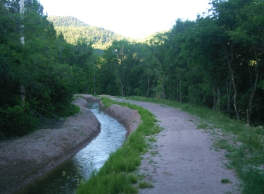
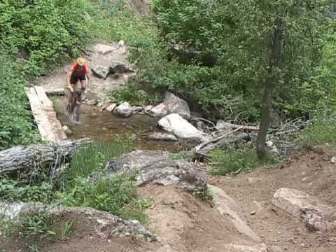
The first section of trail is smooth as silk. Then come gnarly creek crossings. (Note: you might consider stone-hopping the deeper creek crossings to keep your chain dry. The trail is often very powdery. Once enough grit settles on your chain, it will get sticky. Chain lock-up on the small ring was a problem on this trail.)

View up the trail. The trail stays fairly close to the creek, to your right in t...
View up the trail. The trail stays fairly close to the creek, to your right in this picture. August 24, 1999 by Bruce Argyle
Eyeballing a sharp, tricky drop into the creek, over the handlebars of the Docs ...
Eyeballing a sharp, tricky drop into the creek, over the handlebars of the Doc's bike. August 24, 1999
Short but difficult rock-strewn climbs are common on the way up. We share this trail with horses, and unfortunately, they tear the hell out of steeper trail sections. Your bike handling skills and strength will be tested. The creek becomes smaller and drier, but you'll have plenty of chances to fall in.
The trail climbs through spruce and aspen. Watch for fishermen along the trail. The trail usually clears of snow in May, but the gates to the upper canyon are closed until July. (High flow in the creek makes early riding dicy, anyway.)

As you near the top, you'll have your first chance to get a view. And to let the dog explore.

The creek fades away to almost nothing near the top. Here a tiny waterfall has c...
The creek fades away to almost nothing near the top. Here a tiny waterfall has created a bowl in the conglomerate rock. Photo August 24, 1999
A moose meanders through the meadow. For a longer ride, you can continue on over...
A moose meanders through the meadow. For a longer ride, you can continue on over the ridge. August 24, 1999 by Bruce Argyle
At the top, the Dry Creek Canyon Cutoff Trail forks off at the stock pond. This is where most bikers make the turn-around. The downhill run is truly awesome. You won't regret the brutal ride up. The trail twists, dips, climbs, and plunges through the creek for a grin-inducing downhill.

Old video of a ride on Wadsworth...

[Back to video list ]
If you want, you can continue 4 miles further on the main trail to Halls Fork Road.

Or, you can fork left at the pond and cross over the ridge to ride down Dry Fork Canyon on the west, completing the ride as a loop by riding back up the road to the trailhead. The Dry Fork Cutoff Trail is narrower and much more technical than Wardsworth. It's a great downhill if you're an advanced-level rider.

Flannel Mullein blossoms along the creek. The large fuzzy leaves of this plant a...
Flannel Mullein blossoms along the creek. The large fuzzy leaves of this plant are most useful, which is why it's known among campers as "toilet paper plant." The seed stalk makes a great flaming sword when dry -- therefore the other name, "Boy Scout torch." August 24, 1999
Riding notes, Wardsworth to Dry Fork Loop ride:
0.0   Through gate and up ST
        N 40° 11.735' W 111° 23.505'  Alt=6050'
1.5   Keep L, ignore smaller ST on R
3.0   At pond, fork L on narrow ST
        N 40° 13.498' W 111° 22.744'  Alt=7175'
3.5   L on DT at ridgetop (Dry Fork Cutoff)
        Go 100 feet, then R on ST
        N 40° 13.701' W 111° 23.004'  Alt=7350'
6.8   Join Dry Fork trail
        N 40° 12.510' W 111° 23.505'  Alt=5875'
7.5   Gate, L on paved road (Dry Fork trailhead)
        N 40° 12.050' W 111° 25.079'
9.0   Back at Wardsworth Trailhead
Wadsworth Creek loop ride.
Getting there:
Take the south Springville exit (260) from I-15, turning east on U-77. Go straight through Springville. As you begin to climb the foothills, you'll come to a 4-way stop. Turn right, following the signs to Hobble Creek. Just past the golf course, the road forks. Keep right and drive 7.1 miles up the Right Fork. The trail begins on your left just before the bridge where the paved road turns to gravel. GPS N 40° 11.735' W 111° 23.505'.
Riding resources for this trail:
Single-page riding guide
GPS track files and route (right-click and "Save as..."):
   Wadsworth GPX
High-res topo map (300 KB): View
Lodging, camping, shops: Links to south Utah County area resources