View over the top of Suncrest, with Box Elder Peak on the left and a bit of Timpanogos on the right. Photos and ride review by Bruce on May 28, 2021.
Traverse TraverseThe Traverse Traverse trail connects
Ann's Trail
of Draper's
Corner
Canyon
trail system to the Mo-mentum trail of Lehi's
Traverse Mountain
trail system. It's a great ride in its own right, with great mountain and
valley views. The trail is 3.4 miles long, but you'll need to take other
trails to
get to Traverse Traverse at either end.
.")
Looking west from Sensei at the Fox Canyon trailhead. The trails begin as doubletrack above the parking lot (center of photo).
Fox Canyon trailhead
The main access point for those who drive to the Traverse Mountain trails
is the new paved trailhead in Fox Canyon. Turn onto the Fox Canyon road
and drive to the top of the pavement. There's parking for around 20
vehicles, with a toilet and other amenities planned. The trail entry is on
the northern wing of the parking complex. At the northwest corner, find a
paved strip leading uphill to a dirt doubletrack (which then turns to the
right uphill). Follow the dirt road 100 yards uphill to where the Sensei
trail crosses. You can reach Traverse Traverse by turning left on Sensei,
climbing to Mo-mentum, then connecting to Traverse Traverse at the top
elevation of Mo-mentum.

Bathroom, picnic tables, bike service, and water at the Elk Ridge trailhead.
Deer Ridge and Maple Hollow trailheads
At the stop sign in Suncrest, get on Deer Ridge Drive (right turn from SLC, straight from Utah Co). Go 0.9 miles and enter the Deer Ridge trailhead. After parking, pedal uphill to the far west end of the trailhead. For Ann's Trail, take the singletrack on the north side of the parking strip to Ann's Connector at the Maple Hollow trailhead.
To park at the Maple Hollow trailhead, turn to the right off Deer Ridge Drive onto Elk Glen Drive at the Deer Ridge trailhead entrance. Then turn left into the parking semi-circle at the Maple Hollow picnic area. Ann's Connector will be straight ahead from the sidewalk. This will take you to Ann's Trail, where you'll continue west to link up with the Draper side of Traverse Traverse.
Most of the Traverse Traverse trail lies at around 5900 feet elevation. The east side starts
at 5500 feet on Ann's Trail and climbs shady Oak Hollow canyon. The west
end is on Mo-mentum
of the Traverse Mountain system at 5700 feet.
The expected riding season is May through early November. In the spring the trail in the trees
of Oak Hollow will be muddy for several weeks after the higher west section
has dried out.

Traverse Traverse begins at this turn on the far western side of Ann's Trail.

Climbing from Draper, we're heading for the Oak Hollow draw. The gambel oak will quickly give way to maples.
While the trail is smooth and fairly easy to ride, it's beyond the capabilities of most beginners
because of the substantial climbing -- and intermediate trails -- required
to reach it. I'm
recommending this ride for intermediates and above.
Traverse Traverse will be part of a longer ride. You can do it as a pure out-and-back starting
from several trailheads, or you can incorporate loops at one end or the
other before backtracking.
For example, when starting from the Draper side, you can loop around Mo-mentum
and northern
Sensei before heading back. The shortest out-and-back is from Oak Hollow
and will be 9.8 miles.

Some turns are a bit tight, and many are off-camber. When descending, you'll need to slow down and use a bit of caution.

Cruising from turn to turn in the maples.
From Corner Canyon, you'll need to get on Ann's Trail. You can head for Traverse Traverse from
above (Maple Hollow or Potato Hill trailheads) or below (Red Rock, Oak
Hollow, or Equestrian
Center trailheads).
Some distances to Traverse Traverse from the Draper side:
Maple Hollow TH: Ann's Connector and Ann's = 2.0 mi
Oak Hollow on Traverse Ridge Rd: BST and Ann's up = 1.5 mi
Potato Hill TH to Ann's uphill = 2.8 mi
Red Rock (Mike Weir) TH BST west to Ann's = 2.1 mi

The mountain views are impressive, and constantly changing.

A cluster of arrowleaf balsamroot announces that it's spring.
Distances to Traverse Traverse from the Traverse Mountain
side:
Northern Sensei and Mo-mentum = 2.0 mi
Southern Sensei, Mo-mentum CCW = 4.3 mi
Southern Sensei to CW Mo-mentum = 4.5 mi
The Oak Hollow portion of Traverse Traverse lies mostly in tall maple forest. When climbing
the lower 3/4 mile, you'll wind back and forth through 16 turns, some
of them a bit tight.
Then the trail breaks out into exposed age and oak slope as it continues
gently climbing. You'll
enjoy great views of the Wasatch Range to the east. You'll also have long
views north over
the Salt Lake valley.

Looking north into the Salt Lake Valley. The large gray stripe is Interstate 15.

At the ridgeline, we're looking east. That's the Traverse Ridge Road on the left, and you can barely make out the Potato Hill and Little Valley trailheads.
At mile 1.3, you'll cross an old ridgeline dirt road. Your climbing from Ann's has
been 450 vertical feet. There's a tiny bit of further elevation gain as
you wind in and out of two canyons, then you begin a gentle descent toward
Lehi's Traverse Mountain trails.
As you cross the doubletrack on the ridge, the singletrack to your left
is Mayors Trail, which can connect you to the top of Lolo's Loop.
From the ridgeline, the trail drops 200 vertical feet over 2.1 miles before reaching Mo-mentum.
(Keeping straight at the trail fork takes you on the gravel pit side of
Mo-mentum, where you'll
arrive at Sensei -- and city streets -- fairly quickly. A 180 turn onto
eastbound Mo-mentum
descends into Fox Canyon where you'll hit Sensei in the middle of Fox
Canyon (see the map).

Early on Lehi's side of Traverse Traverse, heading west through sage.

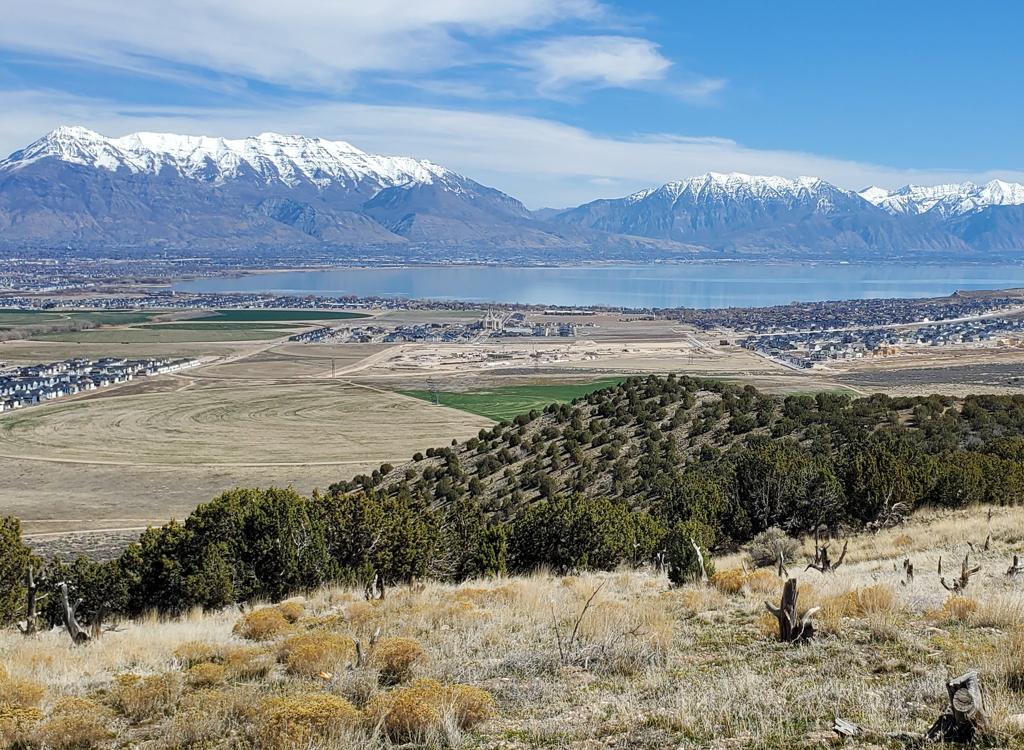
Riding southwest, with Utah Lake in the distance.
This western portion of Traverse Traverse is wide open. On the steep side-slope you find sage
with an occasional stunted grove of oak. To the east, there are constantly
changing looks at
the mountains. To the south are Utah Valley and Utah Lake.
Traverse Traverse ends -- or begins, depending on which direction you're riding -- at the highest
point of Mo-mentum. Here Mo-mentum crosses the ridgeline. To the north
are views into the massive
Geneva Rock gravel pit, an impressive view all by itself.

At the western end of Traverse Traverse, we're looking into the massive Geneva Rock quarry as we join Mo-mentum.

The trail fork on the western end of Traverse Traverse was not marked in May 2021. As you climb westbound on Mo-mentum, the trail fork occurs right as you cross the ridgeline above the gravel pit. Keep left and uphill for Traverse Traverse.
Many riders who started in Draper will now choose to take the loop consisting of Mo-mentum
and a piece of northern Sensei before heading back. It's a fun little
ride that will add 2.6
miles and around 250 feet of climbing to your outing.
Bottom Line!One of the nicest trails in the area, with varied riding surfaces and changing character, plus
some of the best views you'll find anywhere. Great for intermediate riders
or very determined
beginners.

Coming from Traverse Mountain, we're seeing Lone Peak on the left and Box Elder Peak on the right.

Map of Traverse Traverse area
Getting there!
Fox Canyon trailhead. The main access point for those who drive to the
Traverse Mountain trails is the new paved trailhead in Fox Canyon. There's
parking for around 20 vehicles, with a toilet and other amenities planned.
The trail entry is on the northern wing of the parking complex. At the
northwest corner, find a paved strip leading uphill to a dirt doubletrack
(which then turns to the right uphill). Follow the dirt road 100 yards
uphill to where the Sensei trail crosses.
No water or bathrooms at Oak Hollow, Red Rock, or Sensei trailheads.
See the
Traverse Mountain trail page
for
info on Mo-mentum, Sensei, and Lolo's.
See the
Corner Canyon overview page
for
links to individual trails and trailhead info on the Draper side.
Maple Hollow or Deer Ridge trailheads: At the
stop sign in Suncrest, get on Deer Ridge Drive (right turn from SLC,
straight from Utah Co). Go 0.9 miles. For the Deer Ridge trailhead, continue straight into the parking strip at the end of Deer Ridge Drive. For Maple Hollow, turn right onto Elk Glen Drive and after 1/10th mile turn left to park in the semicircle
at the small picnic area. Bathrooms.
Oak Hollow (Traverse Mountain Road): Get on Highland Blvd in
Draper and turn south onto Traverse Ridge Road. About a mile uphill from
Highland Blvd, look for a fenced parking area on the north side of
Traverse Ridge road. The trail exits the east (uphill) side of the parking
lot and descends to the underpass where the BST crosses under Traverse
Ridge Road on it's way to Ann's Trail.
Red Rock (Mike Weir) trailhead: Leave I-15 and climb the hill as
above, but turn right at the light on Traverse Mountain Road. After one
mile, turn left onto Mike Weir Drive. The trailhead parking is on your
right, 1/2 mile later.
Potato Hill trailhead: Take the Bluffdale exit from I-15 and
turn east towards the mountains on Highland Drive. At the light at the top
of the hill, turn right on Traverse Ridge Road. After one mile, you'll
pass Mike Weir Drive on your left. Keep climbing up Traverse Ridge Road.
Look for the Potato Hill TH on your left about mile 1.3 from the light.
Bathrooms.