View down Oak Hollow from the Sensei trail. Trail review by Bruce on October 24, 2018. Latest page update July 22, 2024.
Traverse Mountain
Sensei Trail, Broadband, Dial-up, Mo-mentum, Lolo'sLehi has created a trail system on the west slope of Traverse Mountain. There are several riding loops. The system now connects via singletrack to the trails of Draper and Alpine. Construction was started in 2018. At
this time, 17 miles are complete, including a connector over to Draper's Corner Canyon trail
system and a connector to the south-side Bonneville Shoreline Trail (BST).
Trailhead and connections

Looking north in the trailhead parking lot. The trail
entry is just to the right of my bike.
Fox Canyon trailhead
The main access point for those who drive to the Traverse Mountain trails
is the new paved trailhead in Fox Canyon. Turn onto the Fox Canyon road
and drive to the top of the pavement. There's parking for around 20
vehicles, with a toilet and other amenities planned. The trail entry is on
the northern wing of the parking complex. At the northwest corner, find a
paved strip leading uphill to a dirt doubletrack (which then turns to the
right uphill). Follow the dirt road 100 yards uphill to where the Sensei
trail crosses.
The Sensei trail is the main trail of the system. It starts at the water tank above the Traverse Mountain
homes at 5300 feet elevation. The trail offers easy mellow riding and
great views over the valley.
Navigation to the Water Tank trailhead is a bit
complicated, and at this time involves passing through subdivision
construction. For now (July 2024) plan to use the Fox Canyon trailhead as described above.

Turns are smooth and banked. Looking southwest toward Lake Mountain, with Utah Lake on the left.

Spots where the oak is tall are rare. Most of the ride is sun-exposed.
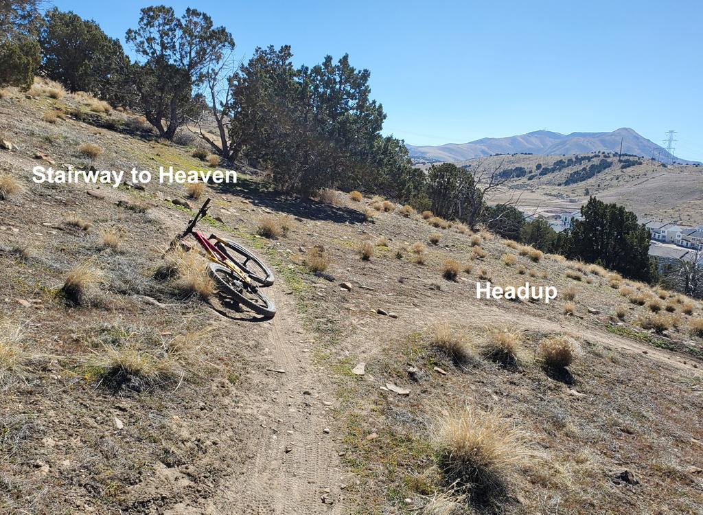
The Sensei trail consists of two segments. The eastern half is 2.7 miles long from the water
tank trailhead to the dirt road crossing in Oak Hollow. The Sensei trail
continues directly
across the road with a 2.3-mile segment that ends near the bottom of the
Fox Canyon subdivision.
If you're not going to ride the whole thing, I recommend you do the eastern
side.
On the eastern side, there's a newer trail that forks off Sensei at the first switchback above the trailhead. This trail is called the Raptor Trail and connects down to a subdivision road where you can link to the eastbound Bonneville Shoreline. See the Traverse Mountain BST page.
The trail surface is smooth and broad. The eastern side has a pitch that's suitable for kids
and beginners. From the water tank, the trail climbs 300 vertical feet
over 1.5 miles, reaching
a top elevation of 6000 feet. It then descends 250 feet over the next
1.2 miles to reach the
Oak Hollow road.

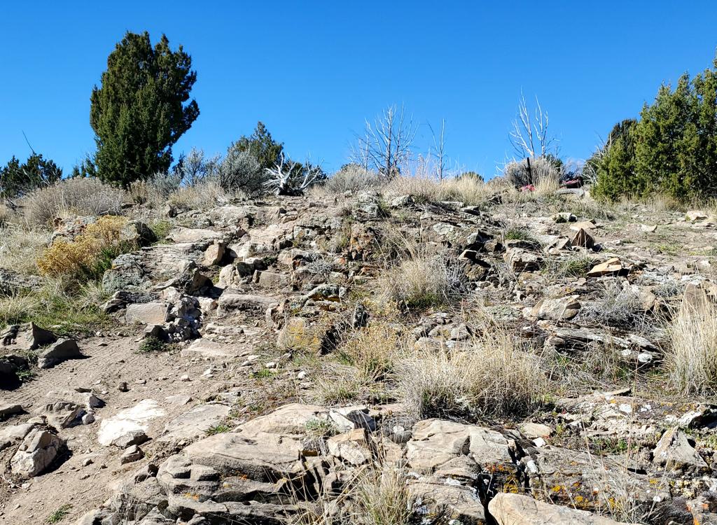
Typical terrain for 90% of the trail -- grass and stunted sage.

The trail surface is smooth and broad.
Most of the trail is sun-exposed, passing through grass and low brush. On the north-facing
slopes, there are small groves of oak brush. Only rarely is the oak tall
enough to provide
any shade.
The northwestern side of Sensei should be solid for riding on most days of the winter and early
spring. It's more sun-exposed and grassy -- rather than forested -- so it
dries quickly. Mo-mentum is a loop option off the western side of Sensei.
(The connector trail to Corner Canyon forks off Mo-mentum.) Note that, in
2024, the eastern connection of Sensei to Fox Canyon road has been
bulldozed by subdivision construction.
At this time, I recommend riding Sensei as an out-and-back. It's
an easy ride, so the 10 miles goes quickly. The out-and-back will have
1200 vertical feet of climbing overall.

Hitting the sidewall on a turn in the oak.

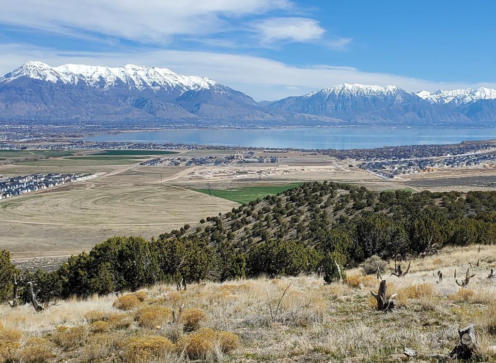
View south on the newly-built trail north of Oak Hollow. All of that wierd-looking area at mid-right will soon be homes.
The southeastern side has many areas with soft dirt. These spots also tend
to be north-facing slopes with trees to shade the trail surface. In most
years the eastern half of Sensei won't be ready for rut-free riding until
mid to late May, and should be avoided after significant rainstorms.
Lolo's Loop is an optional loop off the eastern side of Sensei.
If you're determined to do a loop, you can combine
a bit of gravel road with Vialetto Way (see the GPX track below, 6.4
miles with 900 vertical) or the newer Dialup singletrack. You can also
combine Broadband (see map) with the Fox Canyon road to loop the northeast
section of Sensei.
The Sensei trail clings to the steep slope of Steep Mountain after it passes across the dirt
Oak Hollow road, reaching the ridgeline where you can see the Salt Lake
valley to your left
and Utah Valley to your right. This western segment is 2.3 miles long,
with 100 vertical feet
of elevation gain from the road crossing before it descends to lower Fox
Canyon westbound.

Steep Mountain is, well, steep. Westbound on northern Sensei.

Looking down at some meanders as Sensei descends westbound toward the Fox Canyon Road.
When riding from the western end, it's 300 vertical feet of altitude gain up to the ridgeline.
The initial grade here is significantly steeper than the other portions
of Sensei. This section
has more rock and gravel than the eastern side, so it's ready to ride
earlier in the spring,
and relatively unaffected by rains.
Broadband trail
Connector from Fox Canyon to eastern Sensei

The Broadband trail climbs the hillside through switchbacks to the eastern side of Sensei near its highest elevation. Sensei can be seen crossing in the middle of this photo.
The Broadband trail is 1.4 miles long with 500 vertical feet of elevation change. It forks
downhill from Sensei at mile 1.2 from the water tank trailhead, connecting
to a subdivision
road in Fox Canyon.
At this time, the access from city street to trail hasn't been fully developed. But if you
know where the trail is, you can use it as a nice climbing access to Sensei
from the city.
Currently trail runners seem to be the primary users of this section of
trail, because it allows
a shorter loop.

View on Broadband as we head downhill.
Dialup trail
Bypass Vialetto Way on the loop ride

Trail view on Dial-Up
Dialup connects the eastern Sensei trailhead to a paved trail that climbs a gravel road to Vialetto Way. The bottom of the paved path is on Fox Canyon road. This would be of interest to those who are connecting the two ends of the trail into a loop ride. It's 0.5 miles long with 120 feet of elevation change.
Mo-mentum
Higher-elevation Option on Western Sensei
Mo-mentum is a 2.4-mile alternate higher-elevation line off Sensei. It extends from Sensei in Oak Hollow to the ridgeline just before Sensei descends back to the Fox Canyon Road in the subdivision. It will be popular as a lariat loop ride. The trail is a broad machine-cut with gentle climbing and no technical features.

Wide bench-cut on the dry hillside as we climb up and away from Sensei. I'm doing a clockwise loop around.

View into Geneva Rock north of the trail. We're now on the north side of the ridgeline.
On the western side, Mo-mentum forks to the north from Sensei as it reaches the ridgeline between
Utah and Salt Lake counties. The elevation is 5560 feet. To reach this
spot from Sensei's western
end, you will have climbed 400 vertical feet over 1.4 miles from Fox Canyon
Road.
Mo-mentum climbs eastbound for about 1/2 mile, passing above the Geneva Rock gravel mine. It
will gain about 200 vertical feet. When it reaches the ridgeline again,
you'll have views of
Lone Peak and other mountains of the Wasatch range.

Approaching the ridgeline where we'll cross again to the south side of the hill. That's Lone Peak ahead.

Typical view on the long traverse in the middle of Mo-mentum.
Mo-mentum then begins a long traverse along the hillside. It runs parallel to Sensei, but higher
on the mountain.
At the highest point of Mo-mentum, as it crosses the ridgeline,
Traverse
Traverse
forks away. This trail connects to Draper's
Corner
Canyon
system at
Ann's Trail
.
Mo-mentum then descends into oak and maple forest and crosses Oak Hollow (above the dirt road).
It will quickly drop down through a series of tight turns to join eastern
Sensei 0.1 mile south
of the Oak Hollow dirt road.
A very nice 9-mile ride is to start from the water tank trailhead, take Sensei all the way
to the western end of Mo-mentum, then lariat around and back to Sensei
for the return. Total
climbing will be around 900 vertical feet.

While most of Mo-mentum is exposed, there is some riding in tall maple and oak on the eastern side of the trail.

Looking southwest at Lolo's Loop from near the ride's highest point.
This loop is an option off the eastern side of Sensei. Lolo's Loop connects at 0.7 miles and 1.3 miles from the water tank trailhead and is 2.7 miles long. Lolo's has significant elevation change and is a steeper ride than Sensei or Mo-mentum. A lariat ride from the trailhead around the loop and back would be 4.7 miles long with 650 vertical feet of climbing.
Most riders prefer to do this loop in the clockwise direction, because the climb is spread
out over a longer distance. The top elevation of 6200 feet comes 1.3 miles
from either end.
The northern end starts out 100 feet higher, at the highest point of eastern
Sensei, with 350
feet of climbing. The southern side puts 450 vertical feet into its 1.3
miles.

Connector to Lolo's from Sensei, with a prominent turning platform.

Typical trail view on Lolo's.
The terrain is similar to Sensei. There's a lot of exposed hillside with grass and low scrub,
with occasional groves of gambel oak.
The trail is broad and smooth, with no technical features. There are some hairpin turns on
the slope, which might be a bit much for beginners, so I'm giving this
section an intermediate
rating overall.
Traverse Traverse
Connection to Ann's Trail
The Traverse Mountain system is now connected to Draper's trail system
by a connector across Steep Mountain. The route is 3.4 miles long. See the
Traverse Traverse page for more
details!
The western side of the connecting singletrack is called Traverse
Traverse and forks off Mo-mentum 1/2 mile from its western connection to
Sensei, right as it crosses the ridgeline.. It's 2.1 miles long. As the trail crosses the doubletrack on top
of Steep Mountain, it becomes Draper's Traverse Connector. At this point,
the northern end of Mayors Trail joins.

The western side is open and sun-exposed.

The Draper side has spectacular views at the top and twisty trail in cool maple forest at the bottom.
Draper's (eastern) side of Traverse Traverse forks off of western Ann's Trail and is also called
Traverse Connector. It's 1.3 miles long. The fork is in Oak Hollow, 0.9
miles from the Ann's
Connector trail fork (2 miles from the Maple Hollow trailhead). It winds
up the Oak Hollow
gulley through around 15 turns, gaining around 300 vertical feet in 0.7
miles, then climbs
around the exposed ridge to connect to Traverse Traverse.
Mayors Trail and Lehi's Dream DH

Climbing from the southern end of the trail.
The Mayors Trail is 2.2 miles long, running from the top of the
Lolo's loop on the south to Traverse Traverse on the ridgeline between
Draper and Traverse Mountain. It's a two-way trail that creates some nice loop rides. The Mayors Trail trail is discussed in detail on the Mayors
Trail page. Mayors Trail is also your route to the new Lehi's Dream DH trail and to the Beware of Doug trail (part of Draper's trail system, with a connection downhill to the upper Maple Hollow trailhead). See those trail pages for full details!
The top elevation of Mayors is 6400 feet on the southern end. This
portion is on a north-facing slope and is the highest-elevation trail in
the system, so the expected riding season will start later than the
lower-elevation trails.

Traverse Mountain trail system
Getting there:Fox Canyon trailhead. The main access point for those who drive to the
Traverse Mountain trails is the new paved trailhead in Fox Canyon. There's
parking for around 20 vehicles, with a toilet and other amenities planned.
The trail entry is on the northern wing of the parking complex. At the
northwest corner, find a paved strip leading uphill to a dirt doubletrack
(which then turns to the right uphill). Follow the dirt road 100 yards
uphill to where the Sensei trail crosses.
Water Tank trailhead. From the Timpanogos Highway at 1200
West in Lehi, turn north onto Morning Vista Road. At the roundabout,
continue north (the direction
you were going) on Toscana Hills Drive, then left when you reach Vialetto
Way. Just as Vialetto Way is coming to its highest elevation and is
curving left, turn right onto Annuvolato Way. In around 100 yards,
turn left uphill on Reggio Circle and follow this paved road uphill as far as you can. At
the circle at pavement's end, turn left and climb cindered road to the
gravel parking area at the water tank.
Camping: none
Water: none
Bathrooms: none