
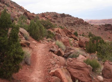
 | Pipe Dream Trail
The Pipe Dream Trail runs along the steep slope just below the cliffs on the southwest corner of the Moab Valley. It's 4.7 miles in length and can be done as an out-and-back of 9.4 miles, or as an 8.2-mile loop ride by including the Pipeline Trail. You can also make a road return via US 191 and Kane Creek Blvd. Technical features are upper-intermediate, but I have to give this trail an "expert" rating because of tight turns and steep side-slopes. Starting altitude is 4150 feet. You'll climb only to 4600, but up-and-down riding will bring total vertical to around 1000 feet. |
| Riding notes, south-to-north from Hidden
Valley TH: 0.0 West on Pipe Dream N38 31.892 W109 31.039 2.6 Stay L uphill (R = to Pipeline) N38 33.028 W109 32.610 Construction detour: R downhill, L at next fork R on Pipeline N38 33.098 W109 32.594 3.4 Stay L uphill (R = to Pipeline) N38 33.340 W109 32.888 4.2 Stay L uphill (R = Pipeline detour rejoins) N38 33.655 W109 33.327 R downhill for loop return via Pipeline | 4.5 R downhill (L=optional connection to Kane Crk Blvd) N38 33.805 W109 33.570 4.7 At street N38 33.889 W109 33.433 Road return: R then L and ride to Kane Crk Blvd R on Kane Crk, R on US 191 8.9 Back at parking |
 | Getting there, Hidden Valley TH: On Main Street (US 191) in Moab, head south. At Kane Creek Blvd (McDonalds on corner), zero your odometer and drive 3.2 miles south on 191. Watch for a Hidden Valley Trailhead sign on your right. Follow this road 1/2 mile to the trailhead parking. The Pipe Dream trail is in the southwest corner of the parking area. Copyright 2011 Mad Scientist Software Inc
|