
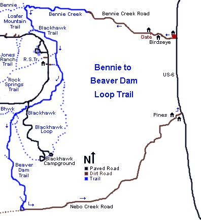
 | Bennie to Beaver Dam Loop This loop is reserved for strong, conditioned riders with good downhill skills and a sense of adventure. Riding from an altitude of 5400 feet at Birdseye in Spanish Fork Canyon, you'll climb to 8400 over the top of Payson Canyon, then drop down Beaver Dam Canyon and roll out along Nebo Creek Total climbing on this 22.7-mile loop will be around 3500 vertical feet. Definitely strenuous aerobic. Advanced technical, but can be managed by intermediate-technical riders who are strong and adventurous. |
| Riding notes: 0.0 Start west from parking on S side of church N 39° 55.458' W 111° 32.905' Alt = 5400 0.8 DT goes left of home, through metal gate 2.5 Cattle grate at border of National Forest 3.5 Deer Hollow Trail comes in on R N 39° 56.408' W 111° 35.940' 4.0 DT ends in ST, continue straight ahead N 39° 56.366' W 111° 36.462' Alt = 6600 6.2 Steep up to coral, fork L (Loafer) N 39° 57.122' W 111° 38.454' Alt = 7900 7.1 Fork L up through gate (Blackhawk) N 39° 56.497' W 111° 38.499' 8.5 Fork L downhill (R = out to road + Rock Springs Tr) N 39° 55.819' W 111° 37.822' Alt = 8100 9.3 Keep straight (Ranger Station trail in from R) N 39° 55.410' W 111° 37.574' | 9.6 Fork R at sign (L = Blackhawk
Loop) N 39° 55.147' W 111° 37.617' 11.0 Cross paved campground road N 39° 54.542' W 111° 38.373' Trail through fence going west 11.6 4-way fork - straight 50 ft, then hard L downhill. N 39° 54.155' W 111° 38.337' approx 13 Straight (R = downhill, possible alternate) Climb along hillside 14.7 Trail joins along creek, go L downhill N 39° 51.685' W 111° 37.645' 15.0 Drop onto Nebo Cr Rd, turn L N 39° 51.418' W 111° 37.600' Alt = 6300 20.4 Gate end Nebo Cr Rd, L on paved road N 39° 53.528' W 111° 32.957' 22.7 Back at parking |
 | Getting there:
From I-15 in Utah County, take
the Spanish Fork - US-6 exit and drive up Spanish Fork Canyon. Just past
the Billie's Mountain landslide (about 5 miles up the canyon), turn right
on US-89. Five miles later, spot a small white church on your right. This
is Birdseye. Turn right at the far end of the church, and park along the
south side of the church. The ride starts by continuing west on the road
into Birdseye. Copyright 2002 Mad Scientist Software Inc Trail conditions change, and the layout of a trail may change without notice. Use this trail guide at your own risk. |