View west on one of the dozens of undocumented branching trails in the riding area. I'm calling this the Cactus Loop. Trail review by Bruce on April 4, 2023.
Sun River
Ranger Bart Loop, State Line Loop, "Mystery" trailsThe Sun River riding area lies to the west of Sun River in the Desert Reserve, between the
Virgin River and the Arizona state line. The area has multiple ATV routes and singletrack trails.
Some of the trails are undocumented, with varying degrees of use. Navigation for a newcomer
can be overwhelming. For your first visit, I recommend an "exploring" ride rather than picking
a specific destination.
The most well-known trail in the Reserve is the Ranger Bart Trail. I provide a description
for the most common version of that ride.
But for hard-core mountain bikers, there's nothing like the many loop rides you'll find off
the State Line lariat loop. You can easily do 15 miles and 1500 vertical
hitting the fun stuff
as you meander. To help you find the loops, I'll tell where each of them
is found in relation
to the State Line lariat loop, so read that section carefully, then scroll
down to read about
individual loops. Because these trails are undocumented, I've simply made
up descriptive names.

View of the Virgin River from the Ranger Bart trail.

Riding along the edge of a rock outcrop on the Garnet Loop.
The starting elevation for these rides is 2450 feet at the western end of Sun River. The high
is around 2800 on the cliffs of the State Line ride, and the low 2400
in the sandy flat near
the Virgin River. In addition to the trails described here, other doubletrack
trails extend
a couple of miles to the west toward the Virgin River Gorge. The area
is considered a year-round
riding area. It does see occasional snow in winter, and if the trails
are muddy, you shouldn't
ride.
There are no trail markers whatsoever, other than the occasional line of rocks to herd riders
along. At this time, there are also no accurate on-trail internet resources
to guide you. There's
a map showing the official trails at the trailhead. With all the many
unofficial routes, it's
not particularly helpful to the typical out-of-towner. So come prepared
to find your own way.

Looking north as the Garnet Ridge trail returns back to the entry DT.

Looking west from the large parking area. You can make out the gate and kiosk in the middle of the photo.
Ranger Bart Trailhead
Exit I-15 at Sun River and take Sun River Parkway westbound to the end
of the pavement. Drive to the primitive parking area west (left) of the
park. The trail entry will be on the left side of parking, at the northern
(far) end. On your bike, drop down through the wash and proceed to the
gate and kiosk. This is the Ranger Bart Trailhead. Once inside the gate,
drop through a second shallow wash on the doubletrack trail. After
climbing out of that wash, the
singletrack to your left is the Garnet Ridge trail which is the route to
the State Line lariat ride. 100 feet further up the doubletrack, the
singletrack that veers to the right is the Ranger Bart trail.

Looking southwest at the entry. There's room for 5-6 vehicles in the open area to the right.
Eastern Gate
Go to Sun River as above and start westbound on Sun River Parkway. Turn left onto Angel Arch
Drive. After the road crosses the wash, turn left (south) on a dirt
road. Veer to the right along the freeway. Park in the dirt in front of
the gate. Pedal across the cattleguard and look for a singletrack trail on
your right. Take this trail 0.6 miles downhill. It will join the Road 560
doubletrack at the Desert Reserve gate. Go through the gate. On your right
will be the Garnet Ridge singletrack (if you're headed for Ranger Bart or
Garnet Ridge Loop), and on the left is the Inspection Station singletrack
(to connect to the loops in the southern reserve).
State Line Lariat Loop
(not an official name)

Looking south as we leave the entry doubletrack. On this portion of the ride, the State Line route is called the Garnet Ridge trail.
This ride extends south to the Arizona state line, makes a small loop, and returns. (Variations
on this ride include a return via the Wash doubletrack, or riding one
of several side-loops
that connect to this route.) The lariat loop as described below is 5.2
miles with 500 vertical
feet of climbing and is an intermediate technical ride. This route is
the key to arriving at
the loops I describe below, so I've created a more detailed description.
From the trailhead parking, pedal across the wash to the entry gate. Coast down and across
a second small wash. At mile 0.1, turn left on the well-used Garnet Ridge
singletrack. (The
narrower singletrack on the other side of the wash will rejoin Garnet
Ridge, and can be used
as a techier alternative.)
Garnet Ridge will veer off to the left to leave the State Line route at mile 0.7 from the trailhead.
Keep right. (OPTION: The trail uphill 120 degrees to your right makes
a lariat "Garnet Ridge
Loop" and will return after one mile. See below.) To continue on the State
Line route, veer
slightly right at this trail fork.

The trail generally follows a northbound drainage. Know which direction is south, and when in doubt, go that way.

Looking back north toward the Pine Valley mountains at a spot where the trail has been "assisted" by ATVs. Motorcycles and ATVs will be found here, which can make the riding surface chunky.
Cross the Road 560 doubletrack at mile 0.9. You're now on the Connector trail. For a short
time, the route is doubletrack. When you see singletrack again, veer to
the left. A doubletrack
joins from the left at mile 1.2.
Around mile 1.3, the singletrack Inspection Station trail will join from the left. It actually
joins twice -- once just after the doubletrack and again at mile 1.3.
The State Line route
now follows the official Inspection Station trail. You'll notice a trail
forking away and climbing
the hill to your left. Keep straight. (OPTION: Climb up and around the
"First Left Loop." See
below.)
At mile 1.5 from the trailhead, the State Line route turns 90 degrees to the right at a trail
fork. The trail that's slightly to the left can be used as an alternate,
because it arrives
back at the State Line route in just under a mile. (OPTION: The trail
on the left goes to the
"Second Left Loop" and returns after 1.5 miles. See below.)
At mile 1.7, you'll pass through a line of posts from an old fence. 100 yards later at the
top of a rise, a trail forks uphill right -- but you might not see it.
This is our loop return
-- or a shortcut route for riders who are heading for the singletrack
to the west of the Wash
DT. (OPTION: Go right and pedal to the "Cactus Loop." See below.) For
our ride, we'll keep
straight.

Cruising across the flats southbound. If you didn't know what waits for you on the "side adventures," you'd think this ride was boring.

View from the cliff line at 2800 feet elevation. If we opt for the Wash DT return, we'll be in the middle of this photo. If we do the singletrack lariat, we'll be on the trail that you can see at mid-right.
You'll reach a spot where you get a glimpse of the freeway ahead at around mile 1.9, and the
trail will turn to the right to begin switchbacks up the hill. Climb to
the top of the hill,
and meander along the cliff edge.
After descending away from the cliffs, the singletrack passes near a powerline, and you'll
drop onto the doubletrack Wash Trail. Turn to the right on the DT (mile
2.6) and descend. (OPTION:
Find and ride the "West Loop" from the uphill end instead of this piece
of the Wash DT.)
At mile 2.9 a westbound singletrack forks away on the left and climbs uphill, but it's unlikely
you'll see it unless you know exactly where it is, because it starts on
open rock. For our
ride, we'll coast another 100 feet downhill on the DT, then veer to the
right on the singletrack.
(OPTION: 50 feet uphill from the singletrack, there's an entry to the
lower end of the "West
Loop" See below.)

As we begin the descent from the cliffs, we can see the "Welcome to Arizona" sign along I-15.

Here's the return singletrack as it forks away from the Wash DT. (If you're looking for further singletrack to the west and the connection to Arizona, it's behind us, uphill about 50 feet on the opposite side of the DT.)
The singletrack now climbs up and over a saddle. It occasionally runs over open rock and a
shallow wash-bottom, so at times you have to just pedal straight ahead
on faith. The eastbound
route splits about 100 yards from the little cliff-line you see ahead
of you. If you see the
trail fork, the left path goes below the rocks while the trail straight
ahead goes to the top
of the rocks before turning north. (OPTION: The connection to the "Cactus
Loop" is 0.2 miles
from either end of this trail segment.
You'll be back at the Inspection Station trail at mile 3.4. Now just backtrack the way you
came.

Here's the Ranger Bart singletrack as it forks away from the entry doubletrack. It will rejoin DT, then fork away to the right again.
The Ranger Bart trail is a combination of singletrack and doubletrack that forms a lariat loop
above the Virgin River. The ride is around 2.5 miles with 100 feet of
climbing.
At mile 0.2 from the trailhead parking, veer to the right on singletrack. The singletrack will
traverse around the small hill, while the ATV route goes up and over.
You'll rejoin the ATV
path shortly. At mile 0.5, veer to the right off the ATV path onto singletrack
again. It's
mellow at first, then begins a cruel climb.
At the top, enjoy some views over the Virgin River. As the trail descends again, you'll come
to a viewpoint area with doubletrack trail, at mile 0.8. The singletrack
trail to the left
will be your return to this spot, and the doubletrack trail ahead is Ranger
Bart.

On that tough climb up to the cliffs over the Virgin River.

Looking toward the Virgin River from the ride's highest point, 2560 feet elevation.
Follow the trail as it turns north, then turn right as the trail joins doubletrack at mile
1.4. (Some riders turn left here for a quicker return. Certainly there's
less sand if you do
so.) Follow the doubletrack around the meander until you're going south,
then south-southeast.
You'll join the shorter-version doubletrack.
When you reach a larger doubletrack at a T intersection, that's the Sun River Mesa DT trail.
Turn left so you're going eastbound and climb away from the sandy bottom
area.

After descending from the viewpoint, you'll run on doubletrack just above the river as you continue west.

The doubletrack route passes through mesquite, then tamarisk in the sandy areas near the river.
At the top of the first hill on the Sun River Mesa DT trail, turn left uphill on doubletrack,
then keep left onto singletrack and pedal around the hill. You'll arrive
at the viewpoint you
visited earlier, where you can turn to the right to return to the trailhead.
Garnet Ridge Loop (not an official name)

Looking north toward the Pine Valley Mountains. We're now riding around the loop.
The loop I'm calling the Garnet Ridge loop is at mile 0.7 of the State Line ride (above). Take
a hard right turn uphill. If you're arriving via the Garnet Ridge trail,
just keep straight
and left as you cross over the State Line route.
It's exactly one mile to climb up to the far side of the bluff, make the loop, and return back
to the State Line route. There's about 100 vertical feet of climbing.
At the far end of the loop, a connector singletrack drops down to the Road 560 doubletrack.
Unless you want to go there, make a 180 turn at this trail fork and return
back to where the
loop started.

Looking west as the loop returns lower on the hillside.

The Garnet Ridge trail passes through a wash. We're mid-way between the State Line route and the eastern edge of the Reserve.
The Garnet Ridge trail funs from the eastern gate of the reserve to the doubletrack Ranger
Bart trail 1/10th mile from the main trailhead. The northern 0.7 miles
of Garnet Ridge is used
by the State Line ride before Garnet Ridge veers off to the east. The
eastern side of this
route is used mostly by locals, or by compulsive riders who "want to do
it all." Total length
is 1.1 miles.
Fenceline or Weigh Station Loop (not an official name)

We're at the split in the loop. From here, it's uphill in both directions.
The Fenceline or Weigh Station Loop lies outside of the Reserve. It's heavily used by locals
to walk their dogs, but it's a nice quick ride with some views. You can
find the "Weigh Station"
trail by riding Garnet Ridge east to the Reserve gate, then taking the
Access Singletrack uphill.
(The Fenceline trail is actually a continuation of an entry trail from
a neighborhood gate
off Grapevine Drive. Don't go there to park. Reserve this entry for homeowners!)
As you ride uphill away from the Reserve gate on the Access singletrack, turn right after 0.3
miles when a singletrack crosses. Cross the main dirt road. Keep to the
right at a trail fork
shortly after. The trail will pass to the west of the truck inspection
station on I-15. You'll
arrive at a trail split at mile 0.8 from the Access ST. Go either way
and circle around the
loop. On the western side, the trail runs along a fence, separated from
a trail along the fence
inside the Reserve. The out-and-back is 2.1 miles; 2.7 if you're counting
from the spot where
you exited the Reserve.

Looking north toward the Inspection Station and the Pine Valley Mountains from the top of the loop.
Inspection Station singletrack

Looking north toward the homes of Sun River from the Inspection Station trail.
At the eastern gate of the Reserve (0.6 miles from the east parking via the Access singletrack),
the Inspection Station singletrack trail forks left off the Road 560 DT.
It veers to the south
around a low hill, then joins the State Line route after 0.3 miles. The
State Line route now
follows the continuing Inspection Station trail.
First Left Loop (not an official name)

After passing through badlands and colorful rock, it seems anticlimactic to arrive at the top and find meadows.
Just a tiny bit further up the State Line route from the junction with the Inspection Station
trail, singletrack drops through the wash to your left and climbs the
hill. This trail will
fork after 50 yards. The right (lower) side traverses above the wash to
join the stem of the
Second Left Loop at its bottom. Keep left and uphill.
At 0.1 mile, the trail splits again. This is the start of the loop. But to complicate things,
the southern side of this loop shares a little bit of trail with the climb
up to the Second
loop. Go to the left. At the top, the trail will drop down and intersect
another singletrack
where you'll turn right. Go around a turn, then fork to the right again
as the other trail
turns to the left. Descend back down to the State Line route. This lariat
is 0.5 miles with
around 50 feet of climbing.

Where the First Left Loop flirts with the larger, more defined trail of the Second Left Loop, things can get confusing. Just keep riding.
Second Left Loop (not an official name)

At the top of the loop and preparing to descend back to the loop fork, looking north.
The Second Left Loop is a fine ride. About 1/10th mile south of the First Left Loop entry,
the State Line route turns to the right uphill. The trail that's ahead
and slightly left is
the entry to this lariat loop. It's a longer ride at 1.5 miles with 100
vertical. Take the
trail around the head of the wash and begin climbing. Ignore the two small
branching trails
that fork left as you climb the stem of the loop.
At mile 0.5, make a hard left turn at the trail fork. (The trail that continues straight connects
back to the State Line route in 0.2 miles, at the point where the State
Line loop begins the
switchback climb up to the ridge. So it's an option if you don't want
to backtrack all the
way to where you started.)
Circle around the loop and descend.

I really liked this little lariat loop. Pretty dirt, a touch of rocks, and a fun descent.
Cactus Loop (not an official name)

This is the alternate "below the rocks" line on the loop portion of the State Line route, looking southwest.
The Cactus Loop branches off the singletrack between the State Line outgoing route and the
Wash DT. If you're riding the singletrack loop clockwise, it's to your
left at mile 0.2 from
the Wash Trail DT.
If you forked to the right off the State Line route just after the old fence, it's on your
right at 0.2 miles.
Keep left at a faint trail fork. (The right option is the cutoff trail and becomes hard to
follow.) You'll roll over a small hill and pass through a field of large
barrel cactus on a
limestone trail surface, then descend along a cliff face. When you arrive
at the bottom of
a wash, the trail turns uphill. The climb back isn't as tough as it looks
in my photo.

Heading toward a field of big barrel cactus and a trail of limestone.

This is the worst spot on the climb up the wash. And it's not bad.
The loop will now join the northern alternate line of State Line loop. Depending on where you
want to go next, either go left to complete the State Line Loop on the
alternate trail, or
turn to the right, then right again, and you're headed toward the Wash
Trail.
West Loop (not an official name)

This is the trail. We're pedaling gently uphill along the lower cliff-line.
The West Loop lies to the west of the upper Wash DT trail. It begins and ends on the doubletrack.
The entry and exit are both hard to spot. The upper end forks left as
you pass a small cliff-line.
The lower end of the trail is 50 feet uphill and across from the singletrack
of the State Line
Loop, going up a shallow limestone wash that doesn't look like a trail
at first.
Climb uphill, and the trail will veer toward the cliff line. After traversing slightly uphill
above the cliffs westbound, it will turn and climb a bench-cut through
the clay to arrive at
a second cliff-line higher up.

Climbing uphill to the trail fork and the upper cliff-line.

We're at the trail fork, looking west.
As soon as you arrive at the top, you'll see a trail fork. To stay in Utah, and stay on the
loop, make the right trail choice. If you're riding the loop counterclockwise
-- lower entry
to upper entry -- go left. If clockwise, go right and downhill.
Riding counterclockwise --
the direction most riders go, the trail will descend around a small canyon
to arrive back at
the Wash doubletrack 0.6 miles after leaving it.
Arizona trail (not an official name)

Looking back at the trail fork as we arrive at the top of the hill. Heading for Arizona!
At the trail fork on the West Loop, you can ride along a higher cliff-line southbound. On the
counterclockwise ride, it's the right-hand forkYou'll enjoy some nice
views. But after 0.2
miles it will turn away to the other side of the hill and begin descending.
One mile later, you'll hit a singletrack along a fence. Turn to the left, and that singletrack
will take you to the dirt road that runs along the freeway. If you stay
northbound on that
dirt road, you'll arrive back the top of the Wash DT, and a bit later,
at the Road 560 DT.

Looking northwest on a trail that runs along a fenceline forever. Behind me is the dirt road that can serve as a loop return back to the Wash.

Northbound on the Wash Trail. Occasionally loose from ATV riders.
Some riders will choose to make a large loop ride out of the State Line route by descending
the Wash DT. Instead of forking to the right at mile 2.9 of the lariat
loop ride as above,
keep straight and follow the doubletrack trail downhill in the wash.
The Wash DT will pass a couple of connecting doubletracks, but keep straight and follow the
most obvious path as it turns toward the right in a sandy bottomland area.
It's now called
the Sun River Mesa trail. You can return via the Ranger Bart trail, but
the navigation can
be complex if you're new to the area. The simplest route back is to stay
on the Sun River Mesa/Road
560 DT until you hit the singletrack that you used to begin your ride.
Turn left there.

A pretty mudstone cliff looms above us in the wash.
Sun River Mesa and Road 560 Doubletracks

Looking east on the DT. The Ranger Bart singletrack is across the hill to our left.
The Sun River Mesa doubletrack is a continuation of the Wash DT. Once the DT turns eastbound,
it becomes the Road 560 DT. In around 1/4 mile from the sandy flat, there's
a connector on
your left over a ridgeline to the entry doubletrack. Or you can keep going
east to where the
State Line route crosses. Road 560 will eventually arrive at the edge
of the I-15 freeway and
connect north into town. (The eastern end of Road 560 DT and the eastern
end of the Wash Trail
DT are connected via a doubletrack parallel to the freeway, should your
ride take you that
way.)
It can serve as a loop return route for either Ranger Bart or the State Line ride if you took
the Wash DT return.
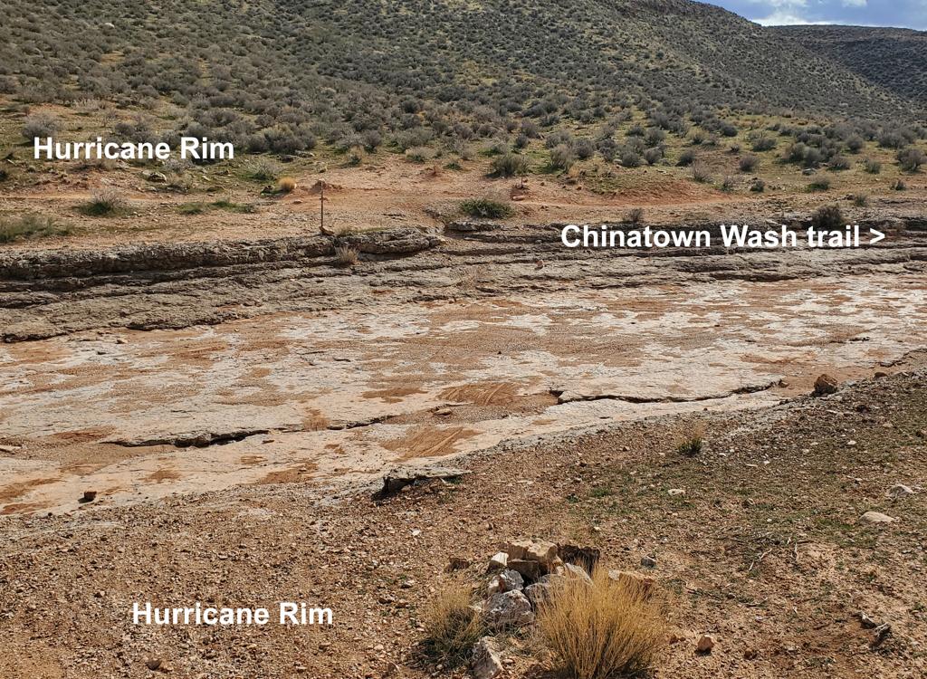
Bottom Line!Some very impressive cliffs, colorful rock, and lots of really fine biking. But to find some
specific piece of interesting riding requires excellent navigation skills.
So these trails
are best when you just go explore and see where the bike takes you. For
less-confident route-finders,
you might want to have a local take you on their favorite tour.

View over a muddy Virgin River from Ranger Bart.

Sun River area map
Getting there, Ranger Bart trailhead:
Take I-15 southbound from St George to the Sun River exit. Turn right and
drive on Sun River Parkway all the way to the end of the pavement. Veer
left and go around the pond. Stay left of the park and find a spot in the
large dirt parking area. The trail entry is the doubletrack that drops off
the left side of the parking lot near the north end.
Eastern Access: Turn left off Sun River Parkway onto Angel Arch
Drive. After crossing the wash, turn left (south) on dirt road on a dirt
road. Veer to the right along the freeway. Park in the dirt in front of
the gate.
To see finer detail, download the multi-track GPS file and zoom in with
your favorite viewer.
Resources:
GPS Track File (Right-click and "Save as...")
GPX Sun River
Lodging, camping, shops:
St.
George area resources