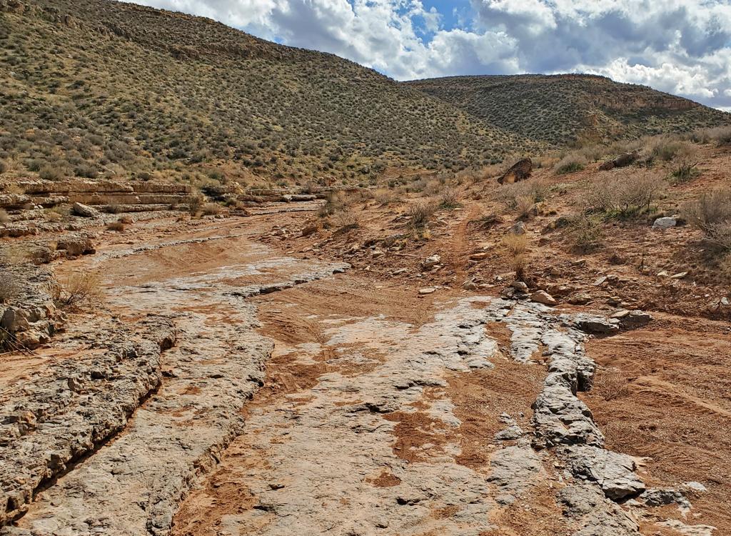
In this view from the Rooster DH trail, the Pine Valley Mountains loom above Cedar Knoll.
Cliffrose Trail SystemThe Cliffrose trail system (also known as Spring Hollow) is on Forest Service land a few miles
north of St George, on the south slope of Cedar Knoll near the Pine Valley
Mountains. The system is complex, offering many different types of riding
and variable mileage. With an elevation varying from 4950 at the trailheads
to 6200 at the top of Just My Pinion, the expected riding season will be April through
December.
The trail system is still under construction at the time of
this updated review, with a new DH just completed in spring 2025. The total
ready-to-ride is 22.6 miles for the system. My original checkout ride in
summer 2024 that hit every trail
was 23.5 miles with 2000 vertical feet of climbing but 5.6 miles have been
added since.
Trails are were originally designated with numbers rather than names,
with the numbers changing at each trail fork. The Forest Service has
combined segments into longer routes and has approved formal trail names
and installed signposts.

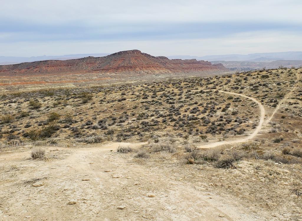
Boulders abound on Just My Pinion on the eastern side of the system. This is the first segment of Just My Pinion, in the "intermediate skill" elevation zone of the mountain.

The Twin Knolls, seen here looking south from the Juniper On The Rocks trail at Spring Hollow, can be appreciated from multiple trails at different elevations.
In general, the system has been designed to facilitate one-way traffic
on loop rides. The climbing route into the system is Get It Together,
either from the FR 091-Spring Hollow parking or from the FR 321 parking
via the lower two-way segment of PJ Party up to Get It Together.
At this time, there are four major DH routes: Dirt Robber (easy),
Rooster (intermediate) to Juniper On The Rocks, PJ Party (expert at
higher elevations, easier as you go down), and the new Cliffrose DH.
The lower-elevation trails near the Spring Hollow trailhead
appear relatively uninviting to the newcomer. This area has been subject
to repeated fires, and is a sea of cheat grass with corpses of trees in
varying degrees of disintegration. Don't let that deter you, because the
terrain -- and the riding -- get steadily better as you gain elevation.
The positive side of the relatively bare hillside on the lower mountain
is that the trails are butter smooth dirt ribbon with only an occasional
manufactured rock rollover. There are loop rides of varying length on the
lower mountain that are suitable for beginners.

Lower elevations of Get It Together are an example of barren -- but very easy -- lower-elevation riding.

Bruce attacks some technical rock on the Just My Pinion trail.
A short ride for beginning riders would be north from
the lower (Spring Hollow) trailhead onto Get It Together. Fork right on
lower PJ Party, then cross Cottonwood Road to Juniper On The Rocks and
ride back to the trailhead. This is 2.5
miles with around 150 feet of climbing.
A longer but still easy ride is to take Get It Together all the way up to the
intermediate elevation zone, then continue east on Fazed Out. When you
reach Dirt Robber, turn left downhill and cruise back to the trailhead. This is 7 miles.

Easy riding and unrestricted views on Fazed Out.

Looking north while winding back and forth on Just My Pinion.
The higher-elevation areas of the Spring Hollow trail system
are on a brown-dirt slope covered with a litter of large volcanic
boulders. The forest is a combination of juniper, cedar, and pinion pine.
Between trees, there's sage and low scrub.
The upper trails are also significantly more technical. The trails wind
around to dodge huge boulders, with more than a little rock embedded in
the trail. Again here, some rock gardens are placed for a riding challenge
-- while others provide a ramp to get up and across a monster boulder.

Banging over igneous boulders. Lots of them on the upper mountain!

On lower Rooster DH, we're riding through pinion and cedar forest toward Cottonwood Road.
The system is built so that easier trails are at lower
elevation near the trailhead. Intermediate trails are at mid-elevation,
and expert tech trails are highest on the hill. If a trail passes through
different elevations, such as the DH route PJ Party, it can require expert
skills at the top yet be an easy cruiser at the bottom.
The upper trails, such as upper Just My Pinion, High Plains Drifter,
and upper PJ Party, are for expert riders or aggressive experienced upper-intermediate riders. The "type" of technical
here is similar to Broken Mesa -- boulder dodging and banging across rock
challenges. And it's not every rider's favorite kind of biking.
A loop climbing Get It Together to Just My Pinion, down the
Rooster DH, then
back to the trailhead on Juniper On The Rocks is a satisfying ride for
upper-intermediate riders. This ride is 9.6 miles with around 850 feet of overall climbing.

Rock gardens abound on the upper mountain. We're descending upper Rooster in this photo.

Parking at FR 901/Cottonwood Road.
Via Cottonwood RoadOn St George Blvd, turn north on 1000 East. Turn right on Red Hills
Parkway. After around 1/2 mile, turn left (north) on Cottonwood Springs
road. Now continue north for 8 miles. When you pass the Broken Mesa
trailhead turnoff, drive exactly one mile further. When you see FR 901
coming in on your left, the lower trailhead is on the right.
A second
trailhead is 0.6 miles further up Cottonwood Road. Turn left when you reach FR 321. In
100 yards, turn left into the primitive parking area. Shown: Spring Hollow
(lower) trailhead.
There are no bathrooms, water, camping spots, or other services at either trailhead.

Parking along FR 321 just above Cottonwood Road.
Via Diamond Valley ConnectorHead north out of St George on Highway 18 (the continuation of Bluff St).
At Diamond Valley, turn right on Diamond Valley Drive. Turn right at
Saphire Drive, then right again at Amethyst Drive. It will curve around.
Just before Amethyst rejoins Saphire Drive, turn right on a small road
with a Lava Ridge trailhead sign. Stay on FR 901 for 4 miles, and it will
end on Cottonwood Road. The lower trailhead is straight across.
To reach
the upper trailhead, turn left for 0.6 miles, then left on FR 321 and left
into parking after 100 yards. Shown: upper trailhead on FR 321.
Individual trail descriptions -- climbing trails
Get It Together (two-way)

Get It Together meanders through the fire scar toward the Pine Valley Mountains.
Get It Together is a two-way trail. Its total length (up to
the intersection with Fazed Out and Just My Pinion) is 2.3 miles. There
will be 300 vertical feet of climbing. Get It Together will be crossed by
PJ Party, and offers a connection to the middle of the Rooster DH.
Lower segment
Get It Together begins on the northbound Juniper On The Rocks 0.1 miles north of the
lower (Spring Hollow FR 901) trailhead. As you pedal north from the
trailhead, fork to the right and begin a
gradual climb through an old burn scar. (The trail on the left at this first fork is the
one-way Dirt Robber DH.)
This first section of Get It Together is very smooth and easy riding.
Toward the top, it enters a sparse
forest of juniper. It's 0.8 miles
long with just under 150 feet of climbing to reach the spot where PJ Party
crosses.
Note that while lower PJ Party is two-way, it's one-way downhill-only
above Get It Together. So do not turn left uphill at this trail crossing.

Entering a grove of cedar and juniper on Get It Together.

Trail fork. On the left is the continuation of Get It Together. To the right is lower PJ Party to the FR 321 trailhead or the top of Juniper On The Rocks.
Option: turn right downhill when you complete the first 0.8
miles of Get It Together and follow the lower segment of PJ Party (trail
121) to Juniper On The Rocks for a small but satisfying loop ride.
Middle segment
Riders who are heading uphill will keep straight as PJ Party crosses,
to begin the second of the three segments of Get It Together.
From the trail fork at mile 0.8, keep straight on Get It
Together to continue climbing. For another 1.2 miles, you'll climb northeast.
You'll add another 200 vertical feet of climbing. Again the trail
surface is smooth, as the terrain alternates between burn scar and
juniper/pinion forest.
As Get It Together reaches its top elevation, it curves left to head
west. Here there's a connector (on your right just after you complete the
left turn) that can take you to the middle of the Rooster DH.

While most of Get It Together is exposed burn scar, you'll spend a bit of time twisting through groves of juniper.

Looking across the open slope as Get It Together ends on Fazed Out.
Final segmentThe last 0.3 miles of Get It Together is a flat stretch through through
grass, with only a couple of small juniper groves. Get It Together ends at
mile 2.3 (2.4 from the Spring Hollow trailhead). At the trail fork, you
can continue an easy ride across Fazed Out to reach Dirt Robber and High
Plains Drifter, or you can turn right uphill for the intermediate-level
climb up Just My Pinion.
Lower PJ Party (two-way trail)

PJ Party climbs north from Cottonwood Road.
The lower segment of PJ Party is a two-way trail. You can
climb this trail from the intersection of FR 321 and Cottonwood Road
031, just downhill from the FR 321 parking area. (At this dirt-road
intersection you'll also find the bottom of the Rooster DH and the top of
Juniper On The Rocks.)
Lower PJ Party passes immediately behind the primitive parking on FR 321. It
lies in juniper forest with a bit of sage and an occasional meadow of
rice grass.
Lower PJ Party is butter-smooth, with a very gradual rate of
elevation change. It's 0.5 miles in length, with only about 50 feet of
climbing when done from FR 321 to the Get It Together fork. One rock garden is built into the trail. Kids will probably want to
walk this. It's only around 15 feet long.
When you arrive at Get It Together, DO NOT continue uphill on PJ Party.
It becomes one-way downhill-only at this spot. Instead, turn right on Get
It Together's second segment to continue your climb.

One singular challenge on lower PJ Party.
Just My Pinion (two-way trail)

Lower Just My Pinion is mostly rock dodging and rollovers.
Just My Pinion begins at the top of Get It Together and
extends uphill to the top of the trail system. It's 4 miles long with 900
vertical feet of climbing. It's a two-way trail used for both climbing and
descending. So watch out for downhill traffic.
Lower segment - Get It Together to High Plains Drifter
The lower segment of Just My Pinion runs between the top of Get It
Together (at the trail fork with Faze Out) and a trail fork with High
Plains Drifter. It's only 0.3 miles long, with around 80 feet
of elevation change.
At the bottom, the trail begins in grassy meadow at the intersection with trails
Get It Together and Faze Out. You'll quickly enter a juniper forest with
large boulders.
For an intermediate trail, the riding on this segment is fairly techy, with massive
boulders to dodge or roll over.

The trail is considerably easier in the downhill direction. All of Just My Pinion is two-way.

Looking uphill as the trail picks its way through huge volcanic boulders covered in lichen. We're just above the High Plains Drifter trail fork.
Middle segment - High Plains Drifter to Rooster DHAfter climbing 0.3 miles, you'll reach a trail fork. To the left is
High Plains Drifter, a traversing trail that will take you around to the
top of Dirt Robber. Ahead and to the right is the 0.5 mile segment that takes
you uphill to another trail fork, where you have the option of diverting
off Just My Pinion onto the Rooster DH.
About half-way up this second segment of Just My Pinion, the
technical rock gives way to easy cruising. On this half-mile section,
you'll gain another 150 vertical feet.
At the trail fork in the burn scar, fork to the left to continue
climbing uphill on Just My Pinion.

Fun stuff!

A typical boulder challenge on upper Just My Pinion.
Uphill segment - Rooster DH to PJ PartyAbove the Rooster DH trail fork, Just My Pinion will climb 400 vertical
feet over 2.1 miles. At the end of this segment, there's a trail fork for
the expert-level DH PJ Party, with Just My Pinion continuing uphill on the
right.
The surface of this section of Just My Pinion is mostly smooth dirt, but embedded
boulders occasionally break through the trail. Some have been engineered
into rock garden features, while others are simply there to dodge or bang
over.
The trail winds back and forth across the hillside as it
gains elevation. The average rate of climb is just 200 vertical per mile.
The occasional rock gardens will make the climb seem like a bit more work.

Almost to PJ Party.

Banging through the rock!
Just My Pinion is your uphill link to the intermediate and
expert-level downhills of Cliffrose. The first trailfork is High Plains
Drifter, which takes you across the hill to the west, then down to the
one-way Dirt Robber. The next fork is for the Rooster DH ride. Next comes
PJ Party, then at the top (although not finished at this writing) the new
DH trail 280.
Final segment - PJ Party to DHAt the trail fork with the PJ Party DH, you've come 2.9 miles from the
origin of Just My Pinion at the top of Get It Together. Keep to the right
to continue uphill.
In 0.9 miles, the climbing will end and you'll find yourself heading
toward a technical rock-drop. This is where Just My Pinion becomes the
expert-level DH.

Riding past a cactus heading north on the final section of Just My Pinion.
Individual trail descriptions -- traversing trails
Faze Out (two-way, lower elevation)

Nice view to the west from Faze Out as we pass through scrub regrowth. We're looking toward the Snow Canyon area.
Faze Out is an easy traversing trail that crosses the Cedar
Bench area. Although it passes through groves of juniper and cedar, most
of the trail is wide open, with views in all directions. Faze Out rides
well in either direction.
Most riders will do it east to west as part of an easy loop of Get It
Together uphill and Dirt Robber downhill. Faze Out can also be combined
with High Plains Drifter and a portion of Just My Pinion for an
intermediate loop.
The surface of Faze Out is smooth dirt, with only an
occasional challenge from embedded rock. It's a good choice for longer
miles on a beginner-level ride when combined with Get It Together and Dirt
Robber.

Faze Out winds through juniper forest in a shallow drainage.

Another view of Twin Knolls to the south, this time from Faze Out and a bit higher in elevation than at Juniper On The Rocks.
Faze Out is 1.5 miles long with only about 50 feet of
elevation change. It's a good choice for packing on the miles without much
work.
High Plains Drifter (two-way, intermediate)

Banging and dodging rocks riding uphill on High Plains Drifter.
High Plains Drifter is a two-way trail. It can be reached by
either Faze Out on the western end or via Just My Pinion on the eastern
end. High Plains Drifter is an
upper-intermediate trail with significant embedded rock. The rock-banging
and rock-dodging will remind some riders of Broken Mesa.
To ride High Plains Drifter as an intermediate
counter-clockwise loop, climb Get It Together to Just My Pinion. Fork left
after the first segment of Just My Pinion. You'll climb a bit on High Plains Drifter, then do a long
traverse, then descend to the intersection of Faze Out and Dirt Robber.
At this trail fork, choose which loop you want to ride!

Bruce cruises on a flat, relatively non-rocky stretch of trail.

Another look south at Twin Knolls. We're now seeing
the mountains behind.
For a clockwise loop, climb Get It Together, then keep
traversing on Faze Out. Turn right uphill when you reach High Plains
Drifter. After an initial winding climb of one mile gaining 100 feet
of elevation, the trail turns to the east to traverse the hillside. It
will gently climb then descend over the next two miles. You'll have views
of the Twin Knolls to the east.
Overall, High Plains Drifter is 3.3 miles long. Both ends are at the
same approximate elevation -- a bit over 5300 -- but up-and-down riding
will create around 200 feet of overall climbing either way.

The trail surface of 230 is often bumpy!

The eastern entry to High Plains Drifter from Just My Pinion shows the new Forest Service trail markers.
The eastern end of High Plains Drifter is on Just My Pinion.
Because Just My Pinion is also a two-way trail, you can use this trail
fork as a downhill or as climbing access to High Plains Drifter.
Individual trail descriptions -- downhill-only trails
Juniper On The Rocks (easier DH, lower elevation)
")
Looking southeast from Cottonwood Road as Juniper On The Rocks heads out. (It gets way better, trust me.)
Juniper On The Rocks is a one-way trail that trends
downhill. The top of the trail is at the intersection of Cottonwood Road
with FR 321. Directly across the road are the exits from DH trails PJ
Party and Rooster.
The trail will descend to the Spring Hollow gorge and follow along the
edge for almost a mile, then climb back to the FR 091 trailhead.
The trail runs along the edge of Spring Hollow, a chasm in
the basalt flow. Juniper On The Rocks is 1.1 miles long, with 100 feet of elevation loss when
ridden from east to west. The trail can be done by beginners but is most
appropriate for early-intermediates.

Bruce approaches the edge of the gorge.

Looking west as we make the gentle descent along the edge of Spring Hollow.
Juniper On The Rocks descends to the edge of the cliffs above
Spring Hollow, then follows that edge before heading back to Cottonwood
Road.
This is a pretty section of trail, and absolutely should be included on
any loop ride you make.
After following the edge of the gorge, there's a bit of
winding climbing to get back to the Spring Hollow - FR 091 trailhead.

Looking west as we make the gentle descent along the edge of Spring Hollow.

Looking uphill through a steppe of cheat grass and juniper on Dirt Robber.
Dirt Robber begins at the intersection of Fazed Out and High
Plains Drifter. This is a lower elevation DH trail (and is therefore easy
to ride).
Dirt Robber is 3.1 miles long with 350
feet of elevation loss. The riding is almost exclusively dirt ribbon, with
no technical challenges. Much of the trail runs through meadows, with a
grove of juniper/cedar in each shallow drainage you pass through.

It's an easy and smooth descending route!

Looking at the entry to Dirt Robber from High Plains Drifter. You can see Fazed Out coming in from the left.
You can connect to Dirt Robber using one of two traversing
trails. For intermediate riders, cross to the west on High Plains Drifter,
then descend to the top of the DH.
Beginning riders can climb Get It Together then traverse to the west on
Fazed Out to reach the top of Dirt Robber without any technical challenges
or stiff climbing.
Rooster - intermediate DH

Rolling north in pinion forest on Rooster DH.
Rooster is a DH-only trail on the far eastern side of the
Cliffrose system. It has two segments: the top half is intermediate in
technical requirement, while the lower portion is fairly easy. The easier
bottom half can be reached via a connector from Get It Together. To get to
the upper trail, take Get It Together to Just My Pinion and climb 0.8
miles.
At the bottom, Rooster ends
at the road fork between FR 321 and Cottonwood Road 031, just down from
the upper (FR 321) trailhead. Across Cottonwood Road is Juniper On The
Rocks to continue downhill.
Overall, Rooster is 1.5 miles long, dropping 400 feet in elevation.
For the first half, it follows the cliff edge of the canyon descending
south from Cedar Knoll. This is a very scenic area, and should be included
in the ride plan for strong bikers.

Upper Rooster is technical due to the rocks. But mostly it's just a straightforward flow trail.

Descending through a turn on the edge of a canyon.
At mile 0.8 of the descent, there's a trail fork. A
connector on the right can take you to Get It Together. (You can head west
on Get It Together to reach Just My Pinion to climb back up.)
After passing the connector, Rooster continues downhill.
It's significantly easier now, suitable for inexperienced or timid riders.
Rooster flattens out as it approaches the bottom, and there'll be a tiny
bit of climbing. Rooster ends as it hits the
intersection of FR 321 and Cottonwood Road.

Southbound on the canyon edge.

Bruce rolls down Rooster.
Across FR 321, lower PJ Party can take
you uphill to Get It Together for another climb. (Note: don't climb PJ
Party above Get It Together - it's one-way!) Across Cottonwood Road, the
Juniper On The Rocks trail can take you along the edge of Spring Hollow and down to the
lower trailhead.

The entry to PJ Party from Just My Pinion.
PJ Party is a DH route from upper Just My Pinion down to
Cottonwood Road FR 031. The total length is 3 miles, with 900 vertical
feet of descent. The DH conforms to the general theme of the Cliffrose
system, in that the upper portion is expert-level, the middle
intermediate, and the lower segments easy.
Riders can choose among four different entries into the DH,
depending on their skill level. Only true experts should go to the very
top. The upper 1.4 miles has difficult rock stunts without ride-arounds.
Intermediates can intercept the DH on High Plains Drifter, where
they'll have 0.5 miles of intermediate-level DH followed by 0.7 miles of
easy DH.
Beginners can intercept PJ Party either on Fazed Out or lower on the
mountain where it crosses Get It Together.

Bruce rolls over some rock descending upper PJ Party.

Sample view down the trail. You might not call it a trail. It can be a slam-fest of rockiness.
The upper segment is highly technical because of the
boulders in the trail surface. This is a very different type of
"expert" than the typical bike-park fare.
In addition to some tricky rock staircases and ramps, there are
unavoidable tombstone rocks right in the trail. You'll need to pick your
line carefully, but you'll also have to work the bike up and over monster
tombstones without hanging up.
Riding in mid-winter, I found that the low angle of the sun --
coming straight into my eyes through the junipers -- often made it hard to
see and react to the boulders.
Most of the rock is naturally occurring but there are a couple of
man-made rumble-ramps. Between rock garden areas, there are some stretches
of trail where you can let it loose and fly.

Bruce clears a tombstone rock. Yes, it's axle-high.

Breaking out of the junipers to see a view to the east.
Top segment - Just My Pinion to High Plains DrifterThis 1.4-mile section of trail drops 500 vertical feet. For long
stretches, there are ugly rocks to contend with. Line-picking can be
critical. For example I thought I could thread through between two
tombstones, but wedged both pedals in and came to an abrupt stop. I should have picked a boulder,
hiked the front tire up and gone directly over.
Second segment - High Plains Drifter to Faze OutThis short section is rated intermediate in tech requirement. Most of
it is straightforward smooth riding, but there are two rock-garden areas
you'll need to bang through. Both are on short climbs.
The second segment is 0.5 miles long, with 130 feet of elevation loss.
This section ends when you cross Faze Out.

Hitting another rock challenge.

Smooth trail typical for the lower mile.
Third segment - Faze Out to Get It TogetherFrom Faze Out to Get It Together, you'll cover 0.6 miles, droping 150
feet in elevation. The trail here is mostly cleared of boulders. There are
a couple of roll-overs that may get harder as the trail erodes.
When you reach Get It Together, that's the end of the one-way trail.
You'll need to watch for newbs and climbing riders.
Final stretch - Get It Together to Juniper On The RocksThe final 0.5 miles is two-way trail, mostly very easy, but with one
man-made rumble-garden. There's only around 50 feet of descending on this
final bit of trail.
The DH isn't really over yet, though. Across Cottonwood Road is the
entry to Juniper On The Rocks. This trail will take you back to the Spring
Hollow FR 091 trailhead.

There are occasional short uphills, like this rock garden climb.
Cliffrose expert DH (official name pending)

We've reached the top of Just My Pinion and are beginning to coast onto the DH. Pick your line.
In May 2025, a new expert-level DH opened on the northeast corner of
the Cliffrose system. As of this review (4 days after the trail opened for
riding), no official name has been offered for this trail.
This DH drops 800 vertical feet over 2.1 miles, then joins upper
Rooster to continue the downhill path. The riding requires advanced
technical skills.
The DH is reached via Just My Pinion. As Just My Pinion reaches the top
of PJ Party, veer to the right uphill. Just My Pinion will continue
another 0.9 miles uphill. When the climbing stops, you're now on the DH.

Typical trail scene: a bit of dirt then a rock garden, then more dirt.

Looking down the steep drop. The rockwork has produced a very ride-able surface, with plenty of smooth trail for recovery when you hit the bottom.
The entry to the DH starts with a steep plunge. To the right is a rocky
ride-around path. The trail rolls over one rock outcrop after another. But
if nothing in the first 1/4 mile stops you, you're good for the rest of
the DH. On the other hand, if you can't stay on your bike through this
first section, you should hike back uphill and use Just My Pinion as your
downhill route.
After that first bit of what seems like unending rock garden, the trail
settles into a routine: plush smooth dirt punctuated by rock roll-overs, drops,
and bang-bang rumble strips. Turns are nicely banked, and a lot of work has gone
into making the rock gardens ride-able.

Preparing to drop down one of a hundred rock challenges.

A banked turn that's so plush, it hardly belongs on this trail!
The last 100 yards of the DH is actually an uphill path that brings you to
the Rooster trail on the edge of the canyon. You'll skip the first 0.4 miles of
Rooster as you continue a one-way trip downhill. Your first chance to exit
before reaching the bottom will be at the interchange of upper Get It Together
with the middle of Rooster. A loop from the trailhead up Get It Together and
Just My Pinion, then down the DH and Rooster plus Juniper On The Rocks, will be
around 12 miles and 1200 feet of climbing.

Dropping away from the 131 connector on Trail 281.
The Cliffrose system at Spring Hollow is an excellent addition to St George's riding options.
Once you get above the barren dry lower trails, it's around 15 degrees
cooler than down in the valley. Looking forward to the completion of this
system, but it's very much worth your time right now.
Getting there:Via Cottonwood Road
On St George Blvd, turn north on 1000 East. Turn right on Red Hills
Parkway. After around 1/2 mile, turn left (north) on Cottonwood Springs
road. Now continue north for 8 miles. When you pass the Broken Mesa
trailhead turnoff, drive exactly one mile further. When you see FR 901
coming in on your left, the lower trailhead is on the right. A second
trailhead is 0.6 miles further up Cottonwood Road. Turn left on FR 321. In
100 yards, turn left into the primitive parking area.
Via Diamond Valley Connector
Head north out of St George on Highway 18 (the continuation of Bluff St).
At Diamond Valley, turn right on Diamond Valley Drive. Turn right at
Saphire Drive, then right again at Amethyst Drive. It will curve around.
Just before Amethyst rejoins Saphire Drive, turn right on a small road
with a Lava Ridge trailhead sign. Stay on FR 901 for 4 miles, and it will
end on Cottonwood Road. The lower trailhead is straight across. To reach
the upper trailhead, turn left for 0.6 miles, then left on FR 321 and left
into parking after 100 yards.