Descending lower Spinal Tap, famous for its rock challenges. Photos and review of lower Spinal Tap by Bruce June 7, 2021. Update for middle Spinal Tap August 22, 2022. Upper Spinal Tap August 30, 2022.
Spinal Tap
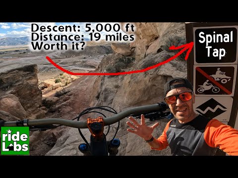
18-mile one-way rideSpinal Tap is an
expert-level one-way trail in the Pahvant trail system near Richfield. Spinal Tap is 18 miles long with 4000 vertical feet of
elevation loss over its length, but you can connect to individual sections
for shorter rides. See the
lower
Pahvant trail page
,
upper Pahvant
, and the
Cottonwood
Kids Loop page
for information on other area trails.
Spinal Tap is divided into three sections: upper, middle, and lower. Each section can be done
independently as a loop or shuttled ride. To ride the entire 18 miles
-- one of the longest
continuous trail rides in Utah -- almost all riders will use a shuttle
vehicle. But it's possible
to loop any individual Spinal Tap section. Or do a monster 34-mile, 4500-vertical
loop of the
whole thing.

Just getting started. The trail starts among aspens and finishes in dry juniper badlands.

Looking east down the ridgeline on middle Spinal Tap. Middle Spinal Tap has lots of colorful dirt and very little rock.
Lower Spinal Tap opened in early summer 2021, with middle and upper Spinal Tap being completed
in late summer 2022. At the time of this writing, some "tweaking" is still
going on, but the
entire 18 miles is open for riding.
The expected riding season for Spinal Tap would be July through mid October. The lower segment
(from One-in-a-Pinion downhill) would be ready to ride earlier, usually
by late May. Most of
Spinal Tap lies on Forest Service land, with the bottom two miles under
BLM management.

Bruce hits a banked turn on upper Spinal Tap at 8500 feet.
Shuttle Route and connections

Looking uphill on FR 096, a bit uphill from the top of Kiln-It.
FR 096You can drive your car up FR096 to shuttle the downhill routes. This
gives you the option of an easier descending route (Faulty, Kiln-It) or
a high-expert route (Spinal Tap). FR096 is the westbound continuation of
300 North street in Richfield.
If you're looking for the easiest possible way to bike to the top, it's the
road. From the
bottom of FR 096, it's 4.1 miles and 1400 vertical feet to the top of
Faulty, 9.3 miles and 2300 vert to the top of middle Spinal Tap, and 16
miles with 4500 vert to the top of upper Spinal Tap. To pedal all the way to the top on
FR 096 and ride down all 18 miles of Spinal Tap is not easy.
Shuttle navigation is straight-forward. Just watch the signs to stay on the main gravel road,
FR 096. You'll encounter major forks at Elsinore Road (which connects
to the top of middle
Spinal Tap) and at the county road for the Paiute ATV Trail #4.
At mile 16 from Richfield, you'll pass a picnic table and toilet on the left on an open ridgeline.
100 yards ahead, the road splits, with FR 096 forking to the right across
a cattle guard. The
entry to the Spinal Tap singletrack is on your right as you cross the
cattleguard. You can
park on the left side of FR 096 at the road fork. Expect around 40 minutes
driving time for
the 16-mile shuttle.

This is what you'll see when you're there.

Pedaling toward the top of lower Spinal Tap on One-in-a-Pinion.
Connection via One-in-a-Pinion
to lower Spinal TapAt the top of Faulty on FR 096, there's a
shuttle drop-off and parking area on the right side of the road (just
before FR 096 drops over the ridge into a valley to the west). A bit south
across the gravel road is the entry to One-in-a-Pinion. This is a two-way
trail that takes you one mile to the trail intersection where middle
Spinal Tap becomes lower Spinal Tap.
Or, you can use One-in-a-Pinion to
exit middle Spinal Tap (for example on a loop ride). It's 100 vertical
feet from the bottom of middle Spinal Tap to the ridgeline parking.

Looking west as we approach the intersection with Elsinore Road. Straight ahead to the top of middle Spinal Tap.
b>Connection via Elsinore Road
to middle Spinal Tap
At mile 7.9 from Richfield, FR 096 turns 90
degrees left after a cattle guard. The smaller dirt road straight ahead is
the Elsinore Road. This road takes you gently uphill 100 vertical feet
over 1.4 miles. Just as the dirt road crosses the ridge, Spinal Tap crosses the road.
In 2022, there's room for a couple of cars here at roadside, weather
permitting.
Elsinore Road can also be used as an exit point when doing a loop ride
of upper Spinal Tap. There's rough parking at the Elsinore Road fork.

Here's the entry to upper Spinal Tap, to your right as you cross the cattle guard. We're looking southeast.
Upper Spinal Tap starts on the ridgeline just south of White Pine Peak at 9700 feet elevation.
It is reached via FR 096, 8 miles uphill from the Elsinore Road fork.
There's primitive parking
on the left side of FR 096 just before it forks to the right over a cattle
guard. The entry
to Spinal Tap is on your right immediately after you cross the cattle
guard.
The trail crosses FR 096 at mile 12.7 from Richfield at 8800 feet elevation (4.7 miles uphill
from the Elsinore Road fork). This is an alternate entry if you don't
want to pedal all the
way to the top, or if the spring thaw doesn't yet allow driving all the
way to the top. The
shoulder of the road is generous in width here, allowing a few cars parallel
parked.
If you opt to hit Spinal Tap at the road crossing, your ride on upper Spinal Tap will be 6.3
miles with 1100 feet of descending.

Looking west on FR 096 as Spinal Tap crosses.

Sample view. Looking southeast.
The upper segment of Spinal Tap is 8.9 miles long. You'll drop 2000 feet in elevation. There's
a bit of pedaling on gentle uphills totaling 200 vertical feet. There
will be views in every
direction if you want to stop to take them in.
Like middle Spinal Tap, the trail is an undulating bench-cut with highly banked corners designed
for speed. The trail is 99% dirt. But when upper Spinal Tap does hit rocks,
it gets highly
technical. This is where Spinal Tap earns its expert rating.

Dirt rollers help to shed water from the trail. And make the ride more interesting.

Bruce cruises through aspen forest early in the ride.
At the time of my checkout ride, cattle had badly post-holed the upper two miles of trail --
a combination of heavy rains and freshly dug dirt in the shadow of the
aspens. This should
smooth out with more riders and TLC, but since this area is summer cattle
range -- and the
trail provides a nice corridor for bovine migration -- expect some rough
trail at times.
The trail begins in the alpine zone of aspen and low scrub. The dirt here is usually deep red.

Looking south as the trail traverses lush hillside.

Rolling down through bitterbrush around mile 7 of upper Spinal Tap. Note the highly banked but gentle turn. We're just downhill from an obligatory jump.
About half-way down, the terrain will transition to bitterbrush, pinion, juniper, and sage.
Gray clay soil will alternate with orange and red.
The trail is designed for expert riders. Some of the uglier rock outcrops have ride-arounds.
But for many natural or man-made challenges, you simply must ride them.
I expect that as time
passes, bypass lines will develop to some of the obligate jumps.

Sample of a drop/jump with no ride-around, looking back uphill. The vertical here is a bit under 24 inches.

Rolling banked turns as the trail twists through pinion forest.
Jumping opportunities come frequently, whether from rollers, intentional gap jumps, and strategically
placed rocks with ramps. These will just get better and better as the
lines are ridden in.
And once you've done the ride, you'll find that a lot of the stunts aren't
as hard or tricky
as they looked at first.

Samples of technical spots. The rock outcrops are brief and few. This drop has an alternate line that bypasses it.

In general, these spots are not as horrible as they appear as you approach them. Most can be rolled.

Here's an outcrop with no ride-around. You'll bang down the boulders at a 45-degree slope.

Another boulder-banger drop, this one with two run-outs for straight slope vs angled descent.

On the lower part of this segment, sage and bitterbrush dominate, with the occasional pinion pine.
As mentioned, there's 200 vertical feet of climbing over the course of the 9 miles of downhill.
This is spread among a half-dozen traverses, with the final climb 1/2
mile above the Elsinore
Road.
Upper Spinal Tap breaks out onto a gentle sage slope as it approaches the middle segment. There
are some banked turns and a couple of jumps.
At the Elsinore Road, cross to begin middle Spinal Tap.

Approaching the end of the upper segment. On middle Spinal Tap, we'll be riding east on the low juniper-covered ridgeline at middle left in the photo.

Cruising and enjoying the views.
Non-shuttled loop of upper Spinal TapPark at the Elsinore Road fork (see above) on FR 096, 8 miles from
Richfield. Pedal 8 miles up FR 096 to
connect to the Spinal Tap trail. Enjoy 9 miles of singletrack. When you
hit the Elsinore Road, turn left and coast 1.4 miles back to your car.
This ride will be 18.4 miles with 2500 vertical feet of climbing
overall.

The entry to middle Spinal Tap across the Elsinore Road. The first half-mile heads east on a flat smooth ridge surrounded by bitterbrush.
Middle Spinal Tap has opened for riding as of August 2022. This section of Spinal Tap is 5.2
miles in length, starting on the Elsinore Road 1.4 miles west of FR 096.
It becomes "lower
Spinal Tap" at the One-in-a-Pinion connecting trail.
The starting elevation of middle Spinal Tap on Elsinore Road is 7750 feet. It will drop 950
vertical feet to an elevation of 6800 at One-in-a-Pinion. There's a bit
of up-and-down riding
with two ridgelines to climb across, making around 300 vertical feet of
climbing as you descend.

Getting into the red dirt zone as the trail leaves the flat.

A view to the east as the trail turns. The ridgeline just above the middle of the photo is where we'll find One-in-a-Pinion.
Middle Spinal Tap has a different character than either upper or lower Spinal Tap. In contrast
to lower Spinal Tap's rock stunts, middle Spinal Tap is entirely dirt.
Expect undulating and
twisting cross-country riding with occasional short expert-level plunges.
The terrain switches between red and orange dirt, brown dirt, and white clay. The first half-mile
is grassland on a flat ridge as you ride through isolated bitterbrush.
When the trail begins to drop downhill, you'll have more-interesting riding. Here the trail
is surrounded by juniper and pinion pine on barren slopes. There will
be occasional breakout
views to the north, east, and south.

Traversing the slope eastbound. This terrain is typical for most of the trail.

Looking down a steep plunge. To ride the loose dirt successfully, you need good brake control, confidence, and the ability to tolerate some speed.
The trail is a machined bench-cut. Turns have high berms. But the ground tends to be loose
and subject to erosion. Steep areas will accumulate loose dirt and pebbles.
These steep plunges
are the reason that this middle segment of Spinal Tap is also rated expert-level.
As mentioned, you'll do about 300 feet of climbing as you descend the 900 vertical feet of
middle Spinal Tap. There are two low ridgelines to climb up and across,
but much of the climbing
is just short stretches of gentle uphill as you wind around eroded hillsides.

Following an undulating traverse as the trail dips below the ridgeline.

Swooshing banked turns as the trail progress to the east.
The theme of this middle section of Spinal Tap seems to be pedal for a while as the trail bobs
up and down, back and forth, then make a sudden loose plunge.
The trail alternates between top-of-the-ridgeline riding and bench cuts that bypass small peaks
on the ridge.

Typical trail scenes on middle Spinal Tap, rolling badlands as the trail enters a small canyon...

..and a bench-cut on steep side-slope, with bermed corners and frequent drainage spots for thunderstorms.
Non-shuttled Loop!You can ride the middle portion of Spinal Tap as a loop, using FR 096 and
the Elsinore Road as the uphill. Park at the shuttle stop at the top of
Faulty. Descend west into the valley on FR 096 and climb to the Elsinore
Road. It will be 5.2 miles and 1300 vertical feet of climbing to get there.

Looking southeast as the trail approaches a banked turn on the edge of the ridgeline.

Here's a steeper segment. The trail drops down this fin through a couple of banked turns before hitting the bench-cut on the far side.
Now descend middle Spinal Tap. When you hit One-in-a-Pinion, fork left and climb 1 mile back
to FR 096 on the ridgeline. The loop is 11.4 miles with 1500 vertical
feet of climbing.
At the trail fork with One-in-a-Pinion, keep to the right to continue to descend Spinal Tap
on the lower section. Understand that lower Spinal Tap is more technical
and has greater injury
potential. So if you struggled on middle Spinal Tap, you should take One-in-a-Pinion
out to
Faulty for an easy descent back to base. See the
upper Pahvant page
for more information.

A carsonite marker sits in the middle of the One-in-a-Pinion trail fork. Spinal Tap continues on the right; while a bail-out to One-in-a-Pinion is on the right.

Starting out in the trees, with red dirt and easy cruising.
Lower Spinal Tap is a downhill one-way trail. The transition between middle and lower Spinal
Tap is at the intersection with One-in-a-Pinion. Lower Spinal Tap requires
true expert skills,
so timid or less-skilled riders should exit Spinal Tap at One-in-a-Pinion.
Let me repeat...
Lower Spinal Tap is a challenging trail. It might "average" an expert rating, but there are
a few spots that require high-expert skill. You know, double-black diamond
ride-or-crash. Only
some of these stunts have ride-arounds at this time. In June 2021, local
trail-builders are
working on alternate lines to meander past some of the more dangerous
stuff. So the trail may
become merely an "expert" downhill, but with high-expert alternate lines.
Not just yet, though.
 line along the rock.")
Trail split, taking the higher (right-hand) line along the rock.

Running into the top of a three-foot drop.
This trail segment is 4.5 miles long, dropping 1300 feet in elevation. It offers quite a few
challenging spots.
You can loop this lower section of Spinal Tap either by climbing FR 096
or by climbing up
Kiln-It or Big Red
then
Faulty
.
Take
One-in-a-Pinion
over to lower Spinal Tap.
Lower Spinal Tap starts out with around a mile of cushy smooth riding through the trees with
a gradual slope. There's an occasional little drop or roll-over that will
make the advanced-intermediate
think, "Oh, I'm riding awesome! What were they talking about with the
"high-expert" stuff?
This isn't so bad!"
The trail begins to follow the top of a spine -- thus the "spinal" part of the trail name --
and things get a whole bunch techier. The trail gets steeper, and the
challenges come faster.

On the spine; rougher than it looks.

About to plunge down; steeper than it looks.
There will be a couple of gut-check steep ramps, covered in slippery dust, where you just have
to let it roll. (The one I couldn't bring myself to do was a double drop
with deep soft dirt
between them. If you fishtail or dig the front tire after the first, and
you're going to go
sideways over the second. A high-school team was digging a ride-around
trail on the day of
my ride.)
And there will be some drops. Slowing down is pointless. You still won't be able to see whether
it's a "huck" or a "roll-it" until you're going over the edge. Some riders
are really good
at hitting this stuff on a first time down. We call these brave and trusting
riders "future
patients." The rest of us, who are making our first careful recon ride
of the trail, will want
to see what's on the other side so we'll slow down so much that we crawl
up to the edge and
choke. That's OK. Just walk the bike back up the trail, do a gut-check,
then get some speed
as you re-approach the edge.
But if you're hitting the steep ramp or drop with speed, it doesn't matter. It's going to be
air. But the ground comes up to meet your tires eventually.

Looking back at an edge. It's possible to just roll this one, because it's got a good transition.

There are actually some very pretty views on Spinal Tap, if you can slow down for a second. Here we're looking east toward the valley.

And now we're looking south at colorful breaks. Oops. Did you notice the four-foot drop just in front of your tire? This is a really beautiful trail!

More rough sandstone. But OK to ride fast.

Even rougher sandstone. Not OK to ride fast.

Almost there! One more wiggle and we're on the final descent to the valley floor.
At mile 4.3 from One-in-a-Pinion, Spinal Tap hits the valley floor. And it does that right
in the middle of a massive ATV and motorcycle playground. Don't try to
find "the bike trail."
There isn't any. Just keep heading in the same general direction, hitting
the motorcycle bumps
if you want, going northeast. Aim for the spot where the mountain seems
to come down next to
the freeway.
Eventually, you'll find yourself on dirt road heading
north between the mountain and the freeway. The road ends on FR096 just
west of the
freeway underpass. To head back
uphill, climb the road a bit over 1/2 mile and find Tank Run on your right
just above
the water tank. It will take you to either Big Red or Kiln-It. (See the
lower
Pahvant trails
page.)

Nice long downhill with quite a few challenging spots!

There's a toilet and picnic table on the left just before FR 096 crosses the cattle guard and Spinal Tap begins.
Shuttle route:On 300 North in Richfield, pass under the freeway and keep straight to
begin climbing the hill. Follow the main road. At mile 2.3, the entry to
Kiln-It (Cairn-Age and Telegraph) is on your right. At mile 4.1, there's
parking and shuttle drop-off for Faulty and One-in-a-Pinion on your right.
At mile 7.9, cross a cattle guard in a small valley. The Elsinore Road to
middle Spinal Tap is straight ahead. Turn right to continue on FR 096 to upper
Spinal Tap. At mile 16 from town, you're there.
There's a toilet and picnic table on the left just
before FR 096 crosses the cattle guard and Spinal Tap begins.
Getting there:Pahvant (northern access) parking: At the north Richfield exit from I-70, turn north (toward the mountains).
As the pavement ends, turn left onto a gravel road, then left again into the
Pahvant parking area. Start the ride either on the small gravel road heading southwest
parallel to the freeway, or on the singletrack near the trail sign (the
two routes will rejoin after 0.3 miles). After 1/2 mile, follow the trail sign by turning
right on a smaller gravel ATV track. (Note there's room for a couple of
cars here where the doubletrack splits.) Veer left onto singletrack after
0.1 mile to head for
Kiln-It, or continue uphill
on the doubletrack for the
Cottonwood Kids
Loop.
300 North (FR 096) parking: From Richfield's Main Street, turn west on 300
North. As you approach the freeway, turn left into the ATV parking lot.
Pedal under I-70 to head uphill on FR096 to reach the top of Kiln-It.
Shuttle: Top of Kiln-It: Drive uphill on FR 096 2.2 miles and
find DT on your right with a carsonite trail marker. Top of Faulty:
continue to mile 4.1 of FR096 and find marked ATV track on the right, with
singletrack across the road on the left.
Bathrooms and water: none at trailheads (businesses nearby)
latest update August 2022


 line along the rock.")