Handlebar view as we finish one turn and roll into
the next. The Great Salt Lake is visible through the trees.
Sessions Mountain Trail SystemThe Sessions Mountain trails lie on the slope of Sessions Mountain just
above Bountiful. The system was designed specifically for biking, with
highly-engineered one-way DH trails. Top elevation is 6900 feet, for an
expected riding season of late May through October. This review May 19,
2024.
There are five trails, organized into a lower loop with two
DH options and a higher loop that begins at the top of the lower loop. The
system has 7.5 miles total, plus the Sessions Mountain segment of the
Bonneville Shoreline Trail (BST) that passes through the bottom of the
lower loop.

Looking southwest from the near the top of the
Bellevue trail.

Bruce rolls a turn climbing Higher Ground.
The loop of Bellevue trail as an uphill plus Shoot To Thrill
as the downhill is 4 miles with around 500 vertical feet of climbing. This
loop is appropriate for early-intermediates.
The upper loop of Higher Ground plus the Twist DH is for
upper-intermediates. It will be 2.5 miles with 450 feet of climbing. At
the bottom of Twist, you can continue directly down the upper-intermediate
Shout trail to the BST.
At the time of this review (May 2024), the trail system has one downside.
And it may be a deal-breaker for many: The trails have
no easy access point. Construction of the planned King Green trail will fix this, but for now, you'll
hike your bike up a very steep slope to reach the trails. Or make a long
ride up Stone Creek and climb south on the Bonneville Shoreline Trail to reach the system, adding 7 miles to your ride. (See the
trailhead info below.)

A rare moment of straight trail on Twist, where you
can take a second to appreciate the view.

Southbound toward Sessions Mountain on the BST.
Arriving via the Bonneville Shoreline TrailStone Creek (Skyline Drive staging area): From
I-15, take the Bountiful 400 North Exit and head east towards the
mountains. Turn on left on 1300 East, which will curve around east to
become paved Skyline Drive. This road will turn R to become Eagle Ridge
Drive. About 0.1 mile after the road turns to dirt (directly under the big
"B" on the mountain) and turns sharply left. At the apex of the
turn is the entry to the staging area. Find the path heading straight east
toward Stone Creek. Go 1.2 miles uphill along Stone Creek to reach the
Bonneville Shoreline Trail (BST). Now pedal 2.2 miles south on the BST.

Sessions Mountain and Holbrook Canyon trailhead.
Sessions Mountain Holbrook Canyon trailheadMost riders will park at the Holbrook Canyon trailhead. If
it's full, there's plenty of roadside parking along Bountiful Boulevard
right outside the trailhead. To get there, exit I-15 at Bountiful 400
North. Keep going east until the road turns and becomes Bountiful Blvd.
Just after you pass the Bountiful Temple, turn left into the parking lot.
Note that a new trail will be constructed that climbs gently from this trailhead up to the Bonneville Shoreline Trail at the base of the trail system.
From the parking lot, pedal your bike out to the entrance.
(Do not go down the steep slope to the bottom of Holbrook Canyon. That's
not a nice cycling route at this time!) At the gate just north of the
parking entrance, go to the step-over entry marked "Holbrook
North" and start up the steep rocky doubletrack.

The way uphill.

Some of it's not too bad. Other slopes are just
ridiculously steep.
Of the next 0.8 miles, nearly 0.6 is hike-a-bike steep. Plan to push or carry your bike up a long brutal hike.
The first 0.4 miles has a gain of just over 400 vertical feet. That's a
20% average slope. Then there's a bit of actual riding before it gets
steep again. Overall, you'll gain 750 feet of elevation in just 0.8 miles.
At mile 0.8 from the trailhead, you'll reach a 5-way
intersection. (There were no signs for my ride, but I understand they'll
be installed in June.) From left to right, the trails are: (1) the BST to
Stone Creek which is your return from the downhill, (2) Holbrook trail --
don't go there, (3) Bellevue which is your climbing trail, and (4) the BST
that descends to the bottom of Holbrook Canyon.

Arriving at the bottom of the Sessions Mountain trail
system.

Heading southwest down the Holbrook North road/trail.
As miserable as the climb up North Holbrook is, most bikers
can safely ride it down to their cars. But it may depend on how much the
trail has been torn up.
Individual trails in the system
Bonneville Shoreline Trail, Sessions Mountain section

Looking northeast on the BST.
As you arrive at the bottom of the system, the northbound
trail (furthest to your left if you came up North Holbrook) is the BST.
This will be the return path from both the Shoot To Thrill and Shout
downhills. The piece of the BST you'll use is only 0.1 miles long.
Bellevue trail - lower climber

A breakout view while climbing Bellevue.
The trail just uphill from the southbound BST is the
Bellevue trail. This is the route uphill for any ride in the Sessions
Mountain system. You'll start your climb at 5950 feet elevation.
Bellevue is 2.1 miles long and gains 450 feet of elevation.
It spends a lot of time winding back and forth, and even has some sections
where you'll coast. The surface is appropriate for beginning riders.

The climbing turns offer a decent, although not
always generous, radius.

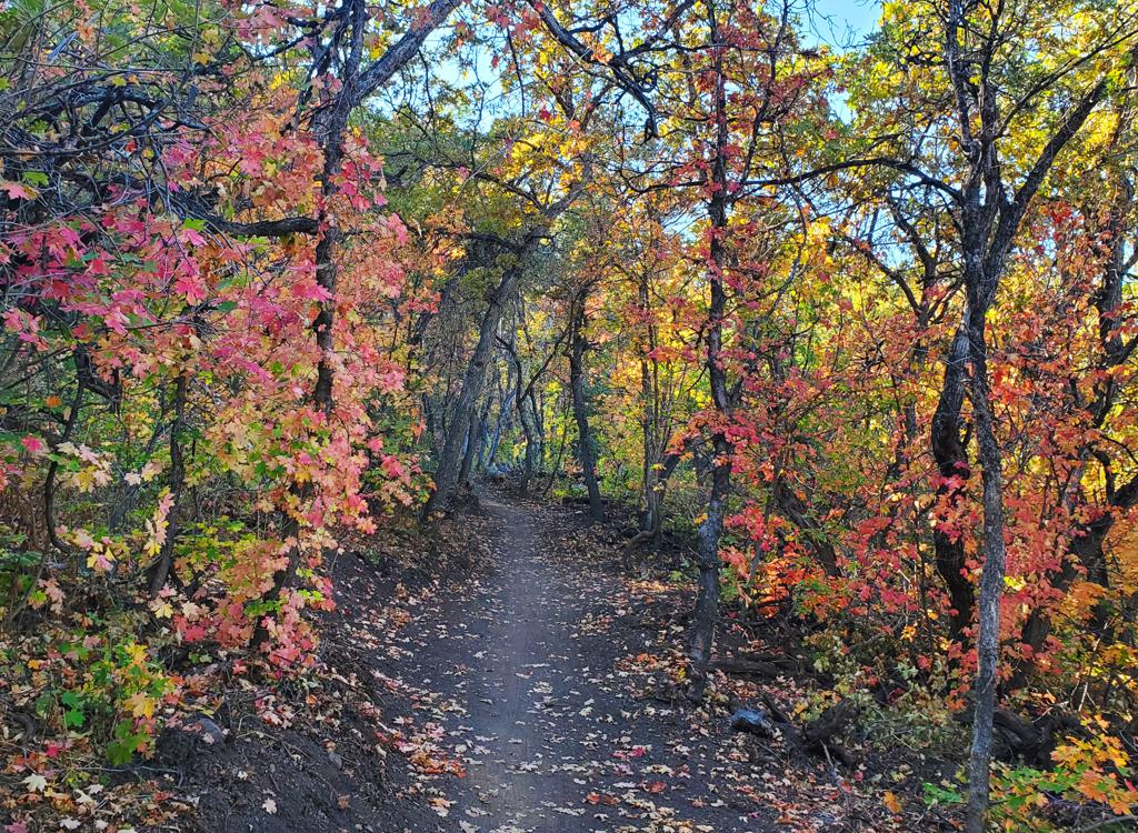
The climb is mostly shady in maple and oak forest.
Most of Bellevue is spent in maple forest with a dwarf
waterleaf under-story. There's a fair amount of shade. Occasionally, the
trail will break out onto dry slopes where grass and low shrubs separate
small groves of gambel oak.
There will be some views of the valley, and of Sessions
Mountain, as you climb higher on Bellevue.

Looking west over Bountiful and the Great Salt Lake.

Another view. You can see the BST climbing away from
Holbrook Creek at mid-left.
Just as your odometer tells says you've pedaled far enough
to be at the top of Bellevue, the Holbrook North trail crosses. Don't be
suckered into turning downhill here. Cross the steep trail and continue
another 100 yards.
Bellevue ends at 6500 feet in a meadow of balsamroot and
mules ear. Here it connects to Higher Ground, the first trail on your
right, which climbs to the top.
Straight across is Shoot To Thrill, a one-way early-intermediate DH
trail. If you're still learning, this is your way down.
90 degrees left is the Shout intermediate DH. It's only slightly more
difficult than Shoot To Thrill. Do NOT enter the second trail to your
right, which is bottom end of the one-way Twist DH trail.

At the top of Bellevue.
Higher Ground trail - upper climber

Starting uphill on Higher Ground.
The Higher Ground trail begins at the top of Bellevue. It's
the climbing route to the top of the Twist DH. Higher Ground is 1.4 miles
in length with 400 feet of elevation gain.
The climbing pace is steady but mellow. Nothing tough or
tricky here. Like Bellevue, much of the ride will be in the shade of maple
and oak forest.

Riding in the forest, with the spring leaves barely
beginning to unfurl at this elevation.

Bruce rolls around a turn on the way to the top.
The forest thins a bit near the top of Higher Ground, so
you'll have an opportunity to eyeball some views. Between groves of gambel
oak are meadows with wildflowers including balsamroot and mules ear in the
spring.
Higher Ground ends with a hairpin turn to begin a DH as
Twist. Turn 150 degrees to the left onto the bench-cut trail. (There's an
older second trail in the area heading northwest, but it doesn't appear to
be getting much traffic.)

ust as you to through the trees, there's a little
turning carve-out. Here you'll swing 150 degrees left to begin Twist.
Shoot to Thrill trail - easier downhill

Descending through mature maple forest as the trail
wiggles back and forth.
Shoot To Thrill is one-way DH trail requiring
early-intermediate riding skills. It is 1.7 miles in length, dropping 450
feet in elevation. The bottom of Shoot To Thrill joins the BST southbound,
so it will be another 0.1 miles back to Bellevue to climb up again.
At the top of the Bellevue trail, Shoot To Thrill begins as
a straight-ahead path through the trail fork and crossover. (To the right
is the climbing trail Higher Ground, then the downhill end of DH Twist. To
the left is the Shout DH.)

A banked turn in a meadow of balsamroot. With a bonus
view!

Traversing downhill, with a table jump coming up.
In general, Shoot To Thrill has wider turns than the other
DH trails. The turns are generously banked, but the berms are not as
steep. There are also longer sections of down-sloping traverse.
There will be some table-top jumps -- which can be rolled, and a lot of
bumps and wiggles. Even though it's a little easier, it's not a boring way
down. So if you've done Twist and Shout, it's worth the trip back up the
hill to hit Shoot To Thrill.
The most technical section of Shoot To Thrill comes at the
end, when it joins the Shout DH. There's a final set of turns that are
more challenging for beginning riders to navigate.

Rolling into a turn.

A rock roll-over gets your attention as you hit the
top of a highly-banked speedy turn.
The Twist DH trail begins at 6900 feet elevation as the
continuation of the Higher Ground climbing trail. You'll descend 400
vertical feet over 1.1 miles.
The Twist trail features a lot of tight highly-banked turns.
The trail seems to be constantly in motion, with very little straight
riding. Sight lines are good.

High speed roller and we whoosh uphill into the
banked turn.

A long ramp of rockwork. It will get your attention,
but it's not tricky.
Twist has a lot of rock rollovers. Some function as jumps or
drops. Others are simply a "heads up" speed check as you roll
into a turn.
For a trail that goes downhill, Twist will give you a good
workout. Definitely not a "sit and coast" ride.

Coming into a 180 turn.

Dropping into a banked turn on Shout.
The Shout trail is the second half of "Twist and
Shout." It begins as the continuation of Twist where the downhill
path crosses the Bellevue climbing trail. Shout is 1.3 miles long, with
450 feet of elevation loss. At the bottom, Shout and Shoot To Thrill join
for 0.1 miles, then it's another 0.1 mile on the BST back to the Bellevue
climbing trail. So your DH is actually 1.5 miles.
Shout has a bit more downward traverse riding than Twist,
with some table-top jumps and rollers.

Coming up on a table jump.

A little action as you enter the turn gives you the
full 180.
Like Twist, the turns are fairly tight and highly banked.
Many turns are linked, forming an S turn. Near the bottom, Twist falls
down a ravine where the turns come fast and furious!
At mile 1.3, Shoot To Thrill will join from your right. Watch for
flying riders! After a set of turns, the BST will join on the right for
the trip back to the bottom of Bellevue.

Fun. Fun. Fun.
Bottom Line!Great trail system. Easy climbing on smooth trail in forest. Some nice
views. Very fun and well-built downhill trails. Consider the 0.8 mile,
750-vertical foot push-a-bike to be the price of admission.
Getting there, Sessions Mountain Holbrook trailhead:
Exit I-15 at Bountiful 400
North. Keep going east until the road turns and becomes Bountiful Blvd.
Just after you pass the Bountiful Temple, turn left into the parking lot.
Now go back out to the entry road and find the dirt road at the gate on
the north (uphill) side. That's the way to the trail system. Push your
bike 0.8 miles uphill.
Stone Creek (Skyline Drive staging area): From
I-15, take the Bountiful 400 North Exit and head east towards the
mountains. Turn on left on 1300 East, which will curve around east to
become paved Skyline Drive. This road will turn R to become Eagle Ridge
Drive. About 0.1 mile after the road turns to dirt (directly under the big
"B" on the mountain) and turns sharply left. At the apex of the
turn is the entry to the staging area. Find the path heading straight east
toward Stone Creek. Go 1.2 miles uphill along Stone Creek to reach the BST, then pedal south for 2.2 miles.

Map of Sessions Mountain Trails