
View west from the trail, as Bruce's bike leans against an aspen. Photos and trail description based on a ride September 19, 2011.
This is a 5.3-mile loop in Empire Canyon, starting just a little uphill from the Ruby Lift
at the Empire Canyon Lodge. The loop starts at 8300 feet elevation on the road to Guardsman
Pass and climbs to 9000 feet at the top of the Ruby Lift. You can reach the loop from other
Park City and Deer Valley trails for a longer ride. This loop originated with the opening of
the new Corvair and Boulder trails in September 2011. Most of the riding is in forest, with
occasional breakouts with views over Park City. At the top, there are views south over the
Heber Valley as well.
If you're driving directly to the loop, go up highway 224 from Park City (the road to Guardsman
Pass). Just after the roundabout at the Empire Canyon Lodge, there will be a hairpin turn to
the right. Just uphill, on the left, is parking.
Drop back down 100 feet from parking and turn left (west) on the
Midmountain Trail
as it crosses the road. You're heading back toward the
lodge.

Here's your trail. Looking west as the Midmountain Trail drops toward Empire from the Guardsman Road.

Typical trail surface. Already well-packed and surprisingly smooth, having just opened for riding two days before. Rain plus bike tires does wonders for a trail.
Keep straight immediately after the road, as Drift joins on the left. Stay straight again at
0.3 as Payroll joins from left uphill.You'll cross ski slope and a doubletrack heading for the lodge. After 0.4 miles from parking,
fork uphill to the left on the Corvair trail.
The Corvair trail will climb through forest of fir and aspen on the north-facing slope of Empire
Canyon. The trail surface is smooth and the climbing is at a reasonable grade. At around mile
0.9, the trail turns from southwest to southeast and begins climbing away from the canyon bottom
towards a meeting with the
TG
trail.

Looking uphill to the west at the hills above Empire Canyon.

The trail alternates between dark fir forest, brushy glens, and mixed aspen and fir. Very pretty.
At mile 1.1, the trail comes into an intersection with TG from below. Keep left and downhill
for the new trail. You'll rejoin TG later, so if you want, you can cross over to TG. TG is
more technical, with additional up-and-down riding when compared with the newer Corvair trail
cut.
The trailcut on Corvair seems to be a "no-climbing" route so that bikers from the top of the
Ruby Lift can cruise down to the Empire Canyon Lodge. So keep an eye open for armored speedsters
coming the opposite direction.
Keep right and uphill where the (currently unmarked)
Payroll
trail forks left downhill at around mile 1.5.

Is this awesome or what?

We've now joined TG heading south uphill. TG undulates and weaves for a fun (but short) section.
The trail slowly climbs around the mountain and joins TG at mile 1.6. Fork hard left as you
meet TG. (Right will take you back to the trail fork where you touched on TG.)
After 1/3 mile (at mile 1.9), fork to the right to leave TG. (The end of TG is just 100 feet
uphill at the road to Guardsman.) This uphill trail had no markings when I rode it, but I understand
it's called Upper Corvair.Here the trail reverses direction almost 180 degrees. Climb through a forest of small aspens
and occasional fir for 1/3 mile.

Heading northwest climbing away from TG on new trail. This section didn't see quite as many tires during its first weekend.

Climbing away from the new track towards Guardsman.
At mile 2.2, fork left uphill. (The right fork drops down to TG north of where you joined it.)
The trail gets more narrow and technical for a short distance after turning back southeast.
As you leave the aspens, the trail hugs the side of a grassy slope, heading toward the ridgeline.
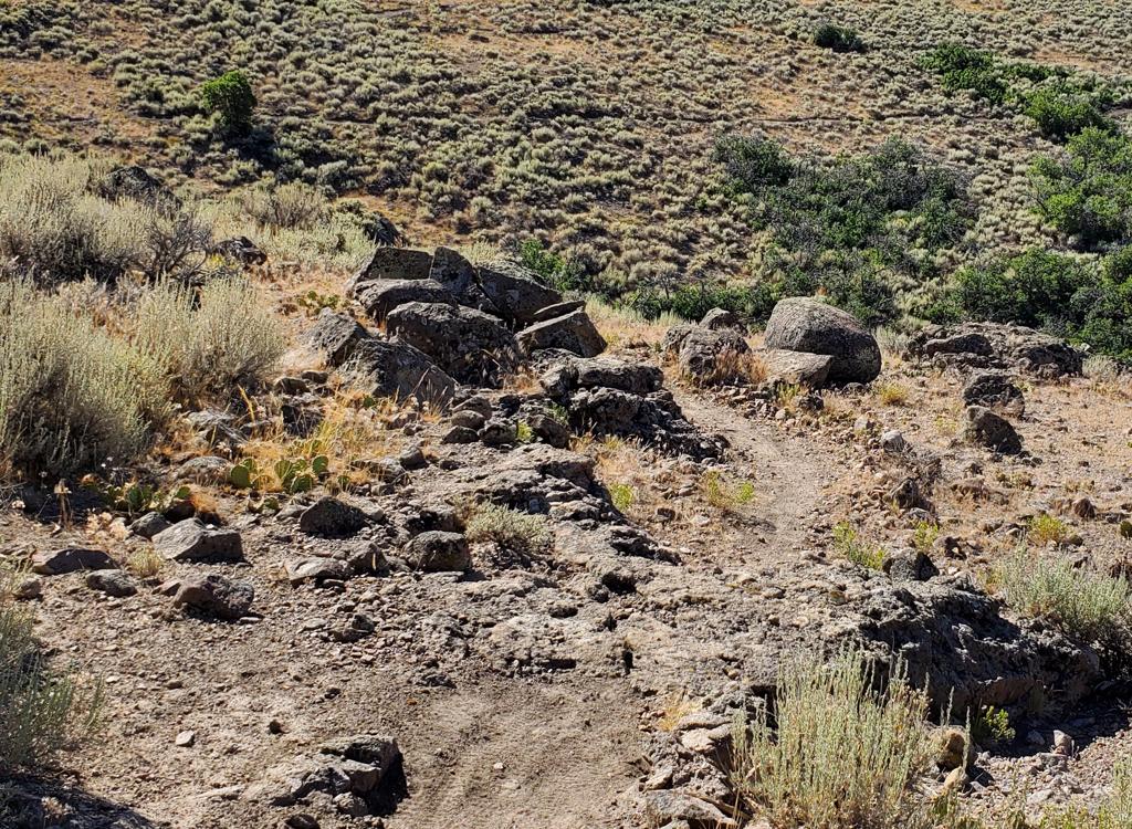
As the narrow singletrack hits doubletrack, fork right uphill toward the big rocks. Stop and
check out the views in all directions.

We're aiming for the spot where the green streak hits the skyline.

View from the top of the singletrack toward the parking area along the Guardsman Road. Negotiate the parking to get on doubletrack heading east-southeast.
Now head left (slightly downhill) on doubletrack. Keep straight through the parking area, cross
the Guardsman road, and keep heading the same direction into doubletrack. Aim to the right
of the hill where you see the ski lift.
At mile 3.2, fork left. Aim for the ski lift to the north. The doubletrack will skirt the east
side of the hill and climb toward the lift.

View to the northeast. New housing and lodges line the slopes along the new Guardsman Road.

Looking east from the Ruby Lift. The singletrack is just past the left edge of the photo.
Pass east (right) of the lift. Stay generally straight and find the downhill Boulder singletrack
northeast of the lift.Plunge downhill. After about 1/4 mile, keep right as a connector to Moose Bones forks away
(mile 3.6).
At mile 3.8, stay straight as you cross Moose Bones to take the Boulder Trail downhill.
At mile 4.1, cross the doubletrack (the connector between
Tour des Suds
and Moose Bones or Team Big Bear) and continue downhill.

Heading downhill on the new trail from the Ruby Lift. I'd strongly suggest that this route is downhill-only. If you want to live.

Typical bermed turn designed for speed.
The trail will zigzag down the hill, crossing ski slopes and turning hard in aspen or fir forest.
The turns are tight but are bermed for high speed. There are a few jump opportunities.
At mile 5.3, keep straight as you hit the Midmountain Trail. The trail
on your left going uphill is the
Tour des Suds
. Ride about 1/10 mile back
to the road and turn uphill to your car.
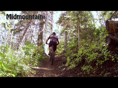
Riding guide, counterclockwise loop:
0.0 Coast down from parking, L on ST
Midmountain Trail N40 36.982 W111 30.445
Stay straight (Drift on L)
0.3 Stay straight (Payroll on L)
N40 36.822 W111 30.493
0.4 L uphill on ST (Corvair Trail)
N40 36.822 W111 30.599
1.1 Keep L and downhill N40 36.641 W111 30.880
1.5 Keep R (L = Payroll)
N40 36.582 W111 30.635
1.6 L on TG Trail N40 36.584 W111 30.650
1.9 L (uphill R = TG to road) N40 36.436 W111 30.488
2.2 L uphill (R = to TG) N40 36.623 W111 30.738
2.5 L uphill on DT N40 36.419 W111 30.628
Then L on DT N40 36.402 W111 30.654
2.7 Cross Guardsman Road to DT N40 36.382 W111 30.475 3.2 L on DT toward lift N40 36.549 W111
30.081 3.3 To R of lift, find ST NE of lift Boulder Trail N40 36.627 W111 30.148 3.6 Keep R
(L = to Moose Bones) N40 36.709 W111 30.214 3.8 Cross Moose Bones, keep downhill N40 36.773
W111 30.093 4.1 Cross DT road N40 36.838 W111 30.234 5.3 Keep straight to Midmountain westbound
N40 37.016 W111 30.403 (L = Tour des Suds, hard R = Midmountain) 5.4 Uphill on pavement to
car
As you enter Park City, follow the signs for Deer Valley and Guardsman Road. Get on Bonanza
Drive heading south uphill. At the roundabout, turn toward Empire Canyon (SR 224). Stay on
that road for about 3.5 miles. Go through the roundabout in front of Empire Canyon Lodge and
head uphill on 224. Just after the turn to the right, park on the left side of the road. The
Midmountain Trail is back downhill just above the turn. Head left (west).