
Dwight's Rocky Point Trail System
(G Hill Trails in Gunnison)
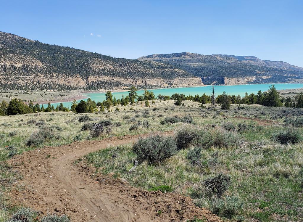
On the northwest corner of Gunnison is a low hill festooned with a "G." This is the site of a trail system, new in 2023 with additional trails added in 2024. There are 8 miles of singletrack. The trails are easy both aerobically and technically with the exception of the tech trails Bone Breaker and Vertigo -- these are tricky. The expected riding season will be mid-April through November.
The trails were purpose-built for mountain biking. The system has an easy climbing trail called Antidote leading from the trailhead to the top of the ridge. Two easy trails descend to the west -- Skin Shredder and Morphine -- with both linking to a cross-country loop in the valley. The loop consists of the trails Penicilllin and Grit and seems designed to be done counterclockwise.
Other easy loops can be put together using Enema, X-ray, or Stitches. Good routes to climb back out of the western valley are Skin Shredder and Morphine.


An easy downhill trail leads from the ridgeline back to the parking area. This is the descending side of the Antidote loop trail.
Elevation change is minimal, with 100 feet of climbing to get over the ridge and 100 on the way back. There are no trail signs in place at the time of this latest update (July 2024).
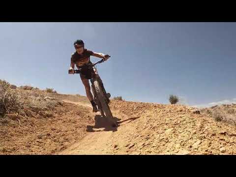
While most of this trail system is mellow cruising, the Bone Breaker front-side tech trail is challenging. It has some well-built challenges that are hard to ride in the southbound direction, and extremely tough when taken uphill riding south-to-north.
The Vertigo trail on the backside of the hill (linking Bone Breaker to Grit) also presents a few expert challenges.


New in 2024 is a bike skills park just above the trailhead. There's a jump line, a roller line for beginners, a boardwalk, and three drop lines with wooden decks. The jump line is reached via the lower Antidote climbing trail, while the top of the drop lines is on the descending side of Antidote.
Trailhead

At US-89 (Main Street) in Gunnison, go west on 300 North. Turn right (north) on 200 West. The road will turn to gravel, and a short bit later (0.4 miles from 300 North), a road turns left into a gravel parking area with a log fence. The outgoing trail called antidote is on the northwest corner of the parking area, on the right as you go uphill from parking. The trail that crosses the wash into the southwest side of parking is the returning downhill trail.
Antidote - To the ridgetop
The Antidote trail will take you to the top of the ridgeline. The main XC riding loop awaits on the other side. In the parking area, go uphill to the northwest (right uphill) corner of the parking area and go through the hold in the fence. The trail will wind back and forth across the slope as it gradually climbs to the ridgeline. It will be 0.6 miles to the top, where you'll hit a dirt road.
The trail leading to the loop is across the road, slightly uphill. Around 30 feet up the dirt road, the downhill portion of the Antidote loop trail forks off to the left.

Downhill portion of Antidote - from the ridge to parking
 trail is the technical frontside singletrack.")
The second half of the Antidote trail forms a loop back to the trailhead. This easy downhill flow trail starts at the doubletrack on the ridgeline where the outgoing trail from parking crosses. It's just 30 feet uphill from the trail crossing, on your left. As you go through the ATV-extruder gate, keep left and downhill as the trail splits. (The trail to the right is the tech trail Bone Breaker.)
The downhill is technically easy, with around 120 feet of elevation loss over its 0.5 miles. You'll finish at the western edge of the parking lot.

Skin Shredder - route to the XC loop in the valley

Skin Shredder starts at the top of the ridge after climbing Antidote. It's the left-most of two trails that descend to the west from the doubletrack on the ridgeline. Skin Shredder will take you down to the XC riding loop.
Skin Shredder starts at the dirt road on top of the ridge and descends 0.6 miles to a trail fork with the main loop. The orientation of the fork suggests that the trail-builders intended for you to keep straight and ride the loop counterclockwise.

Morphine starts on the ridgeline, to the right of Skin Shredder as you arrive at the top of Antidote. It's 0.5 miles long. When used to descend, it will join Penicillin in a direction that would send you on a clockwise loop. (The opposite of Skin Shredder.)
Morphine is also an easy climbing route to exit the western valley. The junction with Morphine is on Penicillin, 0.2 miles north of the trail fork where Skin Shredder joins Penicillin, on your right.
Main West Valley XC Loop - Penicillin and Grit

At the trail fork where the Skin Shredder trail ends in a T intersection, keep straight and right onto the Grit trail. The singletrack will head north and east before looping back to the west and southbound. If I understand corrently, this lower side of the loop is now the Penicillin trail. At mile 0.9, there's a soft new trail on your right (see below). This connects down to the dirt road on the west. For now, keep straight and cross the dirt road just ahead. The singletrack now becomes the Stitches trail.
The Stitches trail will turn downhill and wind around until it drops you onto a dirt road at mile 2.2 of the loop. This dirt road is Enema. Keep straight and left on the dirt road.
After just 1/10th mile on the doubletrack, turn left onto a smaller dirt road that climbs toward the hill. After another 0.4 miles, fork right on an even-smaller dirt road. In another 1/10th mile (mile 0.7 from the singletrack, mile 2.9 of the loop), turn left onto singletrack.
")

The loop singletrack will now turn back to the north. You're now on the southern end of the Grit trail. In 0.2 miles it will cross a dirt road at the base of the mountain. (This is the dirt road you were climbing before you forked to the right.) You'll now enter the most technical terrain of the ride, but it's none too techy.
Keep working north on the singletrack, and cross a second dirt road at mile 0.7 from the doubletrack, mile 3.6 of the loop.


At mile 4.1 of the loop, you'll arrive back at the loop fork, where keeping straight give you another lap, and a hard right turn takes you home.
Connector to DT - X-ray and Enema

The X-ray trail meanders from Penicillin to Enema. It's soft, but is rideable. At mile 0.9 of the main loop when riding clockwise (see above), this trail forks away on your right, just before the loop crosses a dirt road.
You'll make a backwards "S" ride to the north for one mile. This route is less-traveled and is sometimes a bit soft. X-ray ends as it hits Enema.
The Enema trail has a connector that heads downhill just after the junction of Skin Shredder with Penicillin. The trail continues west for 0.4 miles.
The singletrack will end on a dirt road. If you keep straight and left, this road will take you to where the main loop dumps onto doubletrack in 0.7 miles, forming an alternate version of the loop ride.

Bone Breaker

The frontside tech trail Bone Breaker has long stretches of intermediate riding punctuated by absolute expert challenges. This trail makes up for the mellow flavor of the trails on the backside of the hill.
The trail is 1.6 miles long (the longest in the system). Starting at the ridgeline above the parking area, it will roll up and down as it heads south, then drop down to the dirt road to the "G" at the southern end. It can be done in either direction, but the challenges are significantly tougher when you take them uphill -- which happens when you're riding from the southern end.


The trail ends on the dirt road that goes up to the top of the G hill. If you want to make a loop to avoid cranking back uphill through the tech sections, you can coast down to Gunnison streets and take 2nd West northbound back to the trailhead.


Getting there:
At US-89 (Main Street) in Gunnison, go west on 300 North. Turn right
(north) on 200 West. The road will turn to gravel, and a short bit later
(0.4 miles from 300 North), a road turns left into a gravel parking area.
The outgoing trail is at the northwest (right, uphill) corner of the fenced parking area. The trail that crosses the wash into
the west side of parking is the returning downhill trail.
No bathrooms, water, or services at trailhead.
Commercial campgrounds in Gunnison.