Heading east on the Rock Spring trail. Original review and photos by Bruce in Oc...
Heading east on the Rock Spring trail. Original review and photos by Bruce in October 1999. Latest update June 19, 2017.
Rock Spring Trail

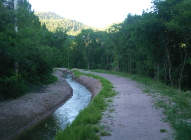
The Rock Spring Trail runs east-west near the top of Payson Canyon. It's intermediate in tech requirement. But at an altitude of around 8000 feet it will require a bit of stamina -- or frequent rest breaks. The trail can be part of many different riding options off the Nebo Loop road.

The Nebo Loop area is famous for its fall leaves. But it's a scenic ride anytime. You'll go through groves of aspen and maple, with the occasional fir. In the early morning, you may surprise deer, moose, and elk as you pop out of the trees into a meadow. Wildflowers are everywhere, and include lupine, mule's ear, daisy, and penstemmon.
Lizard Lake, one of the highlights of the Rock Spring ride.
Heres the Rock Spring that the trail is named after. Youll pass this in the midd...
Here's the Rock Spring that the trail is named after. You'll pass this in the middle of the trail.

The trail...

The Rock Spring trail itself is 4.5 miles long, with up-and-down riding bringing the climbing to around 800 vertical feet. The trail is a key to several other routes at the top of Payson Canyon. It has connections to Shram , Lizard Lake , Jones Ranch , and Blackhawk .

On the eastern end, Rock Spring begins at a large trailhead with a horse corral, on the west side of the Nebo Loop road above the Payson Lakes campground.

As it heads west, it hits the Jones Ranch trail, Tie Fork (Frank Young), Lizard Lake, and Shram Creek. It ends on the gravel Santaquin Road.

View from Rock Spring as the Mules Ear blossom. Compared to other Payson Canyon ...
View from Rock Spring as the Mules Ear blossom. Compared to other Payson Canyon trails, much of Rock Spring's riding offers views.
Rolling through an aspen grove.
Compared to the northern Wasatch, the trails here are virtually empty. On weekdays you'll rarely see another human. On weekends, it's a nice break from the crowded northern trails, yet not far away.

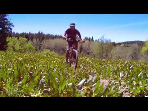
The Nebo Loop area is very popular for horse riding. Steeper areas may be a bit loose after a dry spell, as the horses churn the trail. This trail gives plenty of room to sidestep horses.

There are many loop rides that use a piece of the Rock Spring trail to connect between uphill and downhill routes. For example, Jones Ranch to Shram Creek This page will describe a loop that uses all of Rock Spring.
Descending from the Nebo Loop Road on the Frank Young trail, were at the interse...
Descending from the Nebo Loop Road on the Frank Young trail, we're at the intersection with the Rock Spring trail.
In 2002, Jackie takes a break while I check the healing of a 1999 logging zone.
The Rock Spring and Blackhawk loop

This loop is 11 miles. Starting at 7900 feet elevation, the trail climbs only 500 feet, but up-and-down riding will make the total vertical about 1800. Surface is intermediate technical. It avoids some of the meaner climbing on lower Blackhawk by starting higher on the mountain.

The ride starts at the eastern Rock Spring parking area, but heads across the road to the Blackhawk Trail to start a clockwise ride. To cut off some distance, the trail will shortcut past the Blackhawk Campground on the Bennie Creek Ridge (campground bypass) trail.
Fall rain drops the maple leaves on Blackhawk just west of the campground.
View south down Beaver Dam Canyon as I approach the end of Blackhawk.
Again and again, the trail breaks out to provide fantastic views of nearby mountains and canyons. You'll look east towards the Birdseye area, north down Payson Canyon, and south down Beaver Dam Canyon.
At the Blackhawk trail's west end, we'll take a bit of road to reach the west end of Rock Spring. (For a shorter ride, you can take Tie Fork or upper Lizard Lake to reach Rock Spring. If you cross the Nebo Loop road at Frank Young Canyon, you'll drop straight down to the middle of the Rock Spring Trail.)

There are a couple of gates on this loop. Be sure to close them after you. The gates aren't to keep you out, they're to keep cattle in.

View along the trail in 2017. Much of Rock Spring would rate as a Cruiser -- rel...
View along the trail in 2017. Much of Rock Spring would rate as a "Cruiser" -- relatively flat and straight.
Lizard Lake in this 2005 photo.
Once you find Rock Spring on the gravel Santaquin Canyon road, you just keep heading east and straight at all trail forks. Early in the season, Lizard Lake is a must-see.

There are several riding options to tailor your ride. For a longer ride, without adding a lot of climbing, loop around through the Blackhawk Campground. Another (brutal) add-on is a dip through Holman Canyon.

When you finish your loop, draw straws to see who drives the car, while the rest of you plunge down Blackhawk and take the Bennie Creek Cutoff Trail down to the loop road a couple of miles below.

On the final gentle descent on Rock Spring, heading for the corral.

A portion of Rock Spring is included on this Jones Ranch to Blackhawk video.

[Back to video list ]
Riding Notes, from the trailhead opposite the Ranger Station:
0.0    From the fenced parking area, head right up the ridge
         Find the trail as the doubletrack ends
         N 39° 55.535' W 111° 37.753'
0.25  Trail joins Blackhawk, turn R
         N 39° 55.410' W 111° 37.574'
0.55  Fork R (L= Blackhawk Loop)
         N 39° 55.147' W 111° 37.617'
1.9    Reach road, cross to parking area
         Trail continues through fence
         N 39° 54.542' W 111° 38.373'
         (Ignore smaller trails, keep southwest)
2.6    Fork R and slightly uphill at trail sign
         N 39° 54.155' W 111° 38.337'

4.4    Reach doubletrack, go R to paved road
         N 39° 53.824' W 111° 39.324'
         Turn left on road
5.9    Fork R onto Santaquin Canyon Road
6.9    Fork R off road onto Rock Springs Tr
         N 39° 54.398' W 111° 41.624'
7.7    Keep straight (L=Schram Tr)
8.0    Straight (R=Lizard Lake Tr to Road)
8.7    Straight (R=Tie Fork or Frank Young Tr)
9.9    Fork R on Rock Springs (L=Jones Ranch)
11.1  Doubletrack, continue straight to road
         N 39° 55.676' W 111° 38.068'
         Turn R on road, then L 0.1 mile later
11.5  Back at vehicle

Getting there:  Going south, take the Payson exit 250 from I-15 and turn left. Head into Payson on U-115 to the traffic light, then turn left (100 North, U-198). About 1/3 mile later, at the top of a small hill, turn right at 600 East. Set your odometer now! Keep going up Payson Canyon. Just past Payson Lakes at mile 12.8, you'll see a Rock Spring trail sign on your right. About 1/10th mile down the dirt road is a large corral, with the trail on the left side.

To start from the Ranger Station trailhead, go past the trailhead sign for 1/10th mile. Turn left across from the Ranger Station. Go 1/10 mile to park. Pedal a tiny ways up the dirt road on your right and find the singletrack at the top of the ridge. GPS N 39° 55.535' W 111° 37.753'.

For the Blackhawk Trailhead, continue up the road to mile 14 and turn left at the fork to Blackhawk Campground. About 1/10 mile down the road, there's a turnout on the right. The trailhead is at the log fence, heading west. GPS N 39° 54.542' W 111° 38.373'.

Rock Spring trail
Rock Spring trail
topo map of the Blackhawk/Rock Spring area

Riding resources:

One-page printable trail guide

GPS track files (right-click and "Save as..."):
    GPX multi-track (includes area trails)
Topo maps:  View loop map
2017 upper Payson Canyon trail topo
Lodging, camping, shops: Links to south Utah County area resources Updated 2017.