(with Brandywine, Sheep Bones, DT, Sheep Pen, Hobbiton Hill)
This trail page covers the Lower Riverview singletrack plus other trails in the Riverview/Coyote riding area that lie below and west of Rivendell (aka Upper Riverview Trail). The area continues to evolve, with new trails being added even as this latest 2025 update is being published.

On this web page, I'll first describe the main north-south traversing trails, then the shorter uphill-downhill trails that connect them.


Lower Riverview formerly covered most of the north-south length of the mountain at 2.9 miles. Only 1.1 miles remain north of the UVU entry, with home construction replacing the southern half of the trail. In place of the southern side, you'll need to use Middle Earth or Rivendell (Upper Riverview).
The trail is easy to ride, with less than 100 vertical feet of elevation change.
Frodo's Playground joins Lower Riverview in around 100 feet. Keep left on Lower Riverview, as Frodo's is a one-way downhill trail.
At mile 0.1 from the canal, the UVU Connector turns right uphill and Lower Riverview forks away on the left.


At mile 0.4 from the canal, Second Breakfast (a DH-only trail) joins on your right as Lower Riverview veers to the left. Shortly thereafter, Brandywine rejoins on your left as you continue north.
Bag End forks to the right uphill at mile 0.6. This trail takes you to the Riverview Doubletrack and to the top of the Isengard Skills Area
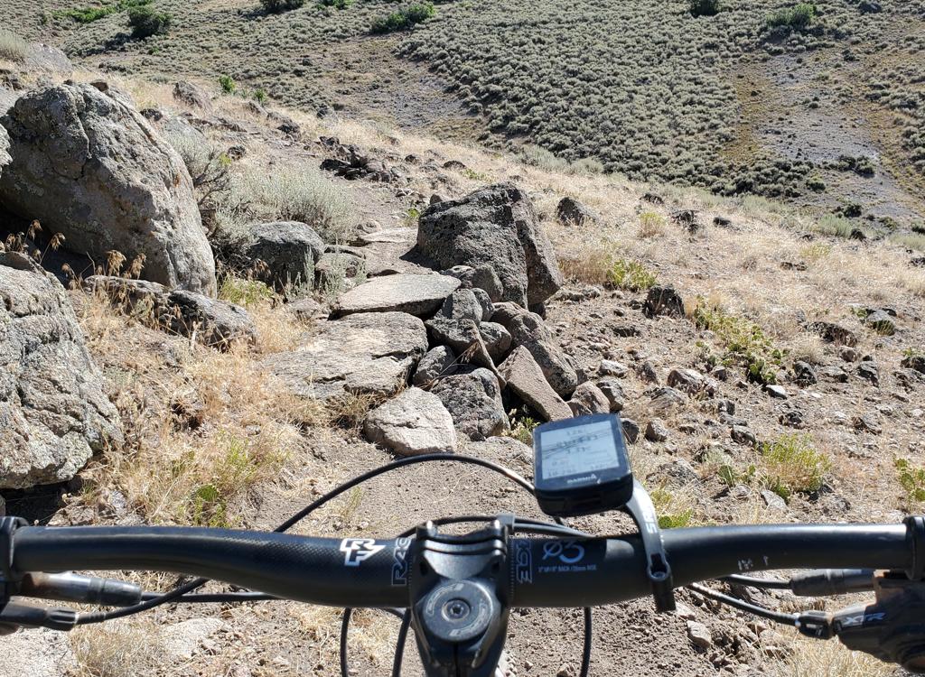
Lower Riverview continues north to the bottom of the Isengard Skills trail, Mordor and Lower Potatoes. You can continue north from here, but the Lower Riverview trail becomes a bit rough with granite boulders and is no longer a beginner-level ride. But the rest of the trail is pretty plush.
Lower Riverview merges onto the Riverview Doubletrack 0.2 miles south of where Sheepbones forks uphill from the DT. By climbing up Sheepbones to Upper Riverview, you'll have a continuous route from Coyote on the south to the Highway 32 (Riverview) trailhead on the north.


After exiting the dip, Sheep Pen forks right uphill.
Subdivision construction is reaching the southern end of the Riverview Doubletrack. Connections and access may change.


To go southbound, turn right at this first intersection. If you're heading north, veer left, then once you see the continuing trail, veer left again on Middle Earth as the UVU Connector forks to the right to continue uphill.
Middle Earth will be crossed by several of the newer DH trails. From north to south, you'll reach Mordor, Second Breakfast, Doors of Durin, UVU Connector (two-way), Frodo's Playground and Bofur's Climb, Hobbit Hole, and Hobbiton Hill before ending on Sheep Pen.


At the northern end, Middle Earth ends at the intersection with the Upper Potatoes trail. You can turn right uphill to climb Upper Potatoes, or continue straight to descend the one-way Lower Potatoes to the Lower Riverview trail.
On the southern end, Middle Earth ends on Sheep Pen.


The Upper Riverview trail was the first trail cut in this riding area and is still wildly popular. The segment on the western side of the mountain is now called Rivendell. On the southern end, Upper Riverview becomes Myrtle at the fork with the Hobbiton Hill trail.
Overall, the original Riverview (now Rivendell and Myrtle) runs from the Connector from the Upper Riverview Trailhead on Highway 32 all the way to the Coyote trail in the south. It's 5.3 miles long with a bit of up-and-down riding. The trail is discussed in detail on the Riverview Trail page.
The north end of Sheep Pen forks off the Riverview DT just a little south of the dip in the DT where the Lower Riverview singletrack merges with the DT then forks away again. The direct route to Sheep Pen is via Coyote to the Lower Riverview singletrack, then forking hard right as the Lower Riverview ST joins the Doubletrack. The entry to Sheep Pen is about 80 feet south on the uphill side of the DT. The northernmost corner of Sheep Pen is the origin of Middle Earth.


Sheep Pen is narrow singletrack winding through scrub oak, sage and cactus. From Coyote to the Doubletrack is 0.9 miles. The trail climbs uphill for an altitude gain of around 150 feet before descending again. On the southern side, a trail fork gives birth to Free Fall. The fork rides best if you're going clockwise on Sheep Pen -- north to south.


Sheep Bones is probably best used as your downhill segment of front-side loop that puts Upper Riverview northbound and Lower Riverview southbound.


These trails make quick and fun rides during the early season, or if you happen to be in the area and want a quick turn on the saddle. Navigation can be a little daunting the first time, especially on the south end where trail forks occur in a sea of sage brush.
Thanks to the Wasatch Trails Alliance as they continue to expand and improve this riding area. Watch their Facebook feed for trail workdays and status updates.
0.0 ST from Coyote TH N40 31.886 W111 24.194
0.5 Join DT N40 31.995 W111 23.943
Cross bridge, then L on ST
0.7 Keep L on Lower Riverview (R = Coyote)
N40 32.125 W111 23.925
0.9 Keep L on Lower Riverview (R = Free Fall)
N40 32.162 W111 23.982
1.3 Keep L to join DT N40 32.386 W111 23.922
1.4 Veer L on Lower Riverview ST
N40 32.402 W111 23.983
2.2 Cross DT above canal N40 32.837 W111 24.615
2.3 L on Lower Riverview (R = UVU Connector)
N40 32.926 W111 24.647
3.4 Hard R on DT N40 33.462 W111 25.213
N40 32.929 W111 24.541
5.5 Straight (Lower Riverview joins)
5.6 Straight on DT (R = Lwr Riverview)
100 feet, then L uphill on Sheep Pen
N40 32.367 W111 23.912
6.4 R on Free Fall N40 32.302 W111 23.707
6.6 Jog 30 ft L on DT N40 32.218 W111 23.866
R downhill to continue Free Fall
6.8 L on Lower Riverview N40 32.162 W111 23.982
7.0 Keep R on Lower Riverview N40 32.125 W111 23.925
7.2 Cross bridge to Coyote ST
7.8 Back at TH
0.0 ST from Coyote TH N40 31.886 W111 24.194
0.5 Join DT N40 31.995 W111 23.943
Cross bridge, then L on ST
0.7 Go R on Coyote
N40 32.125 W111 23.925
0.9 Cross DT, L uphill (R = back toward TH)
N40 32.133 W111 23.824
1.1 Cross Coyote Lane N40 32.184 W111 23.741
1.2 Keep R (L = to Sheep Pen)
N40 32.191 W111 23.700
2.1 Fork L on Riverview N40 32.364 W111 23.405
2.4 Coyote Lane, jog 30 ft downhill to resume ST
N40 32.541 W111 23.387
3.9 Keep L (R uphill = Chop'd Coyote)
N40 33.070 W111 24.047
4.1 Keep R (L downhill = UVU Connector)
N40 33.207 W111 24.238
N40 33.704 W111 25.006
7.1 Hard L downhill on Sheep Bones
N40 34.329 W111 25.057
8.1 Join DT (keep L) N40 33.621 W111 25.278
8.3 R downhill on Lower Riverview
N40 33.460 W111 25.213
9.4 Keep R (L = UVU Connector uphill)
N40 32.926 W111 24.647
9.5 Cross DT above canal N40 32.837 W111 24.615
10.4 Join DT, keep R N40 32.404 W111 23.988
10.5 Fork R to resume ST N40 32.386 W111 23.922
10.8 Keep R (L = Free Fall) N40 32.162 W111 23.982
11.0 Keep R ((L = Coyote) N40 32.125 W111 23.924
11.2 Cross bridge to ST
11.7 Back at TH

Trailhead options!
UVU Wasatch Campus Trailhead: One mile south of the junction of Highway 40 and 32 (a couple of miles north of Heber), turn east (toward the mountain) at the UVU campus. Go to the uppermost level of parking behind the UVU buildings. Look for the duck-under and kiosk. A singletrack trail climbs 1.5 miles to the Riverview Trail.
Wile E Canyon trailhead: The Wile E Canyon trailhead is located on the southern side of Highway 32, just over 4 miles from US-40. It's 1/10th mile east of the old Cutthroat trailhead (see below). There's room for about 8 cars here. From the parking lot, a connector trail takes you 120 yards uphill to the Wile E Canyon loop. To get to Beep Beep (or the Coyote Switchbacks or East Riverview), turn right at the trail fork, keep right at the next fork, then turn left onto the Coyote Riverview Connector trail as you approach the gravel road.
Coyote Riverview Connector trail (old Cutthroat): You can still connect through the old Cutthroat trailhead, although there's no longer a parking area here. For example, if the crowds have forced you to park where construction workers leave their vehicles along Highway 32, you can pedal to the gravel road to the new golf course leaves the highway, four miles east of US-40 and just east of the big rock-wall road-cut.
Puddy Tat parking: On Highway 3 around three miles from US-40, watch for a dirt road turning to the right in a huge sage meadow. There are a couple of buildings across Highway 32 at this spot. The parking spot is just through the fence, with a connection to Puddy Tat on the eastern side of parking. (This spot was still being worked on at the time of my review.)
Riverview trailhead: From US-40 just south of the Jordanelle reservoir, turn east at the traffic light onto Highwat 32 (at mile 14.2 from I-80 if you're coming from the north). On Highway 32, climb 1.1 miles. When you see the second entry into Riverview on your left and a road under construction to your right, the Riverview Connector trail starts on the uphill side of that road just after it leaves Highway 32. (In 2025, there's no longer protected parking here. It's unclear whether the trailhead will be restored when construction is complete.)Coyote Trailhead: The southern Coyote trailhead has been lost to subdivision construction. Access to the southern side the trail system is in limbo, but some riders find their way through the construction zone by pedaling up the gravel Coyote Canyon road.
Canal DT trailhead: Just uphill from the light on highway 32, watch for the canal crossing. Park along the road. Start riding south on the doubletrack just uphill from the canal.
Riding resources:
Single-page, printable trail
guides
Lower
loop w Sheep Pen / Free Fall
Frontside
Loop with Lower singletrack
GPS track files (right-click and "Save as..."):
Multi-track GPX area
master file
Two
Free Falls
Low Loop
(Lwr ST, DT)
Frontside Loop
w Lower Riverview
Maps for printing:
H-Res
topo
map
Lodging, camping, shops:
Links to area resources
Other Riverview area trail pages
Coyote Loop
Riverview
Mordor/Isengard
Chop'd Coyote
Looney Tunes/Wile E
Canyon
Bathrooms: No public restrooms nearby.
Water: Gas stations in Heber, campgrounds.
Camping: Hailstone campground at Jordanelle on US-40, about 6 miles away.
Bike services: Slim and Knobby's bike shop, Heber