View north over Quail Lake from the eastern Lakeside Trail. Photos and ride desc...
View north over Quail Lake from the eastern Lakeside Trail. Photos and ride description for eastern Lakeside by Bruce on December 15, 2016. Update to include South Lakeside January 1, 2017.
Quail Creek Lakeside Trail
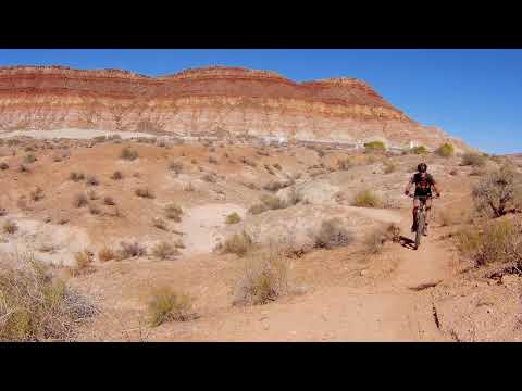
Twist & Shout, East Lakeside Trail

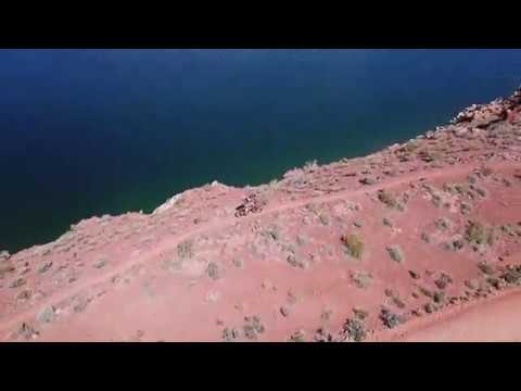
The Lakeside Trail is a route that will -- one day -- go all the way around Quail Creek Lake. The western Lakeside Trail, commonly called the Quail Creek trail , is discussed on another page. This page will discuss first the south Lakeside Trail (officially called the Twist & Shout trail) then the east Lakeside trail. Together these trails go from the west Lakeside ( Rhythm and Blues ) parking to the secondary Quail Creek dam at Harrisburg Gap, a distance of 3.8 miles.

The Lakeside Trail also provides a route from Rhythm and Blues (and the Quail Creek west Lakeside Trail ) to the Boy Scout (Quail Overlook) trails The southern side -- Twist & Shout -- combines a bit of pavement and doubletrack with over a mile of undulating desert singletrack. It connects to the scout camp road just downhill from the eastern Lakeside trailhead, at the bottom of the hill leading to the Overlook trailhead.

The east Lakeside trail joins the northern tip of the Cub Scout Loop of the Overlook trail system, providing a quick route to the northern scout trail loops. (See the Quail Overlook page for details on these trails.)

View east on the Quail Connector, showing the relative locations of the continui...
View east on the Quail Connector, showing the relative locations of the continuing Lakeside trail and the Overlook (Boy Scout) trailhead along the scout camp road.
Twist and Shout
View southeast showing typical trail on the Quail Connector. First photos and GP...
View southeast showing typical trail on the Quail Connector. First photos and GPS track January 1, 2017 by Bruce, updated March 2017.

Twist & Shout starts on the south side of the scout camp road where it forks away from SR 318, 0.2 miles south of the Rhythm and Blues trailhead and 0.4 miles north of Highway 9. (It's the cindered road along the edge of the big chain-link fence. The trail starts on the right side of the road about 50 feet from paved SR 318.) The total distance from the 318 trailhead to the southern end of the east Lakeside trail is 1.7 miles, of which 1.2 miles is winding singletrack. And there's an alternate one-way option called Twist & Shout DH if you're heading west to east.

This trail has a very different character from eastern Lakeside. It lies in white clay badlands of the Moenkopi formation, winding around and through fingers of dirt. There will be a surprising 200 vertical feet of climbing over the course of the trail. The trail swoops, dips, and twists for an exhilarating but unthreatening ride.

While the eastern Lakeside trail is quite water-tolerant, the clay on Twist & Shout gets very squishy when wet. During mid-winter and after rainstorms, I'd advise skipping the singletrack and simply riding the scout camp road to the Overlook trails.

Bruce rolls a turn with the slopes of the Harrisburg Bench in the background.
Getting a bit closer to the East Lakeside trail on the last section of singletra...
Getting a bit closer to the East Lakeside trail on the last section of singletrack.
The ground along the Quail Connector trail is covered with cryptobiotic crust. Don't go off-trail. The crust is composed of living organisms, and will take many years to recover after you stomp on it.

There's a bit of sparse brush. The closest you'll come to a tree is a bit of willow where the trail dips through a seep.

Twist & Shout starts on the western end of the scout camp road, about 100 feet from the highway. After 0.1 mile on the singletrack, you'll reach a fork. Left is the (shorter) two-way route, right is the Twist & Shout DH which is one-way eastbound. The alternate trail will rejoin in 0.4 miles, adding 1/4 mile to your ride.

The DH alternate isn't particularly hard, but it is more twisty - climby - dippy than than the main route. It's new in 2018, so it's a bit narrower and softer.

Twisty view on the one-way Twist & Shout DH optional route. The straighter trail...
Twisty view on the one-way Twist & Shout DH optional route. The straighter trail at the top is the two-way Twist & Shout route.
The trail dips and twists through the desert clay below the Quail Creek dam.
On the main trail, you'll cross a dirt road at 0.2 miles. The DH option rejoins at a second overgrown road at mile 0.4. At 0.8 miles, veer right as the trail hits the edge of dirt road, following singletrack along the right side of the road. Cross a dirt road that's joining the main road, keeping straight. Veer right as the singletrack leaves the roadside after another 100 feet.
At mile 1.2, the singletrack dumps onto doubletrack. Veer left and head north towards the dam. (The road across from you, heading east, drops into a camping spot. It's not the trail, although there's a cheater route from the end of the north campground back to the road that a lot of locals ride.) Go 0.1 miles north. Turn right (east) on the dirt road at the scout camp sign and pedal another 0.1 mile to the Lakeside parking spot (primitive in 2016). If you're heading for the Overlook trailhead, keep going up the gravel road another 0.2 miles.
View north toward the dam as we pedal on the gravel road after the end of the si...
View north toward the dam as we pedal on the gravel road after the end of the singletrack. Camping spots are found along this road.

 The Twist and Shout trail is fun for everybody!

[Back to video list ]
Riding notes, Connector from Rhythm & Blues:
0.0  R (south) on pavement
       N37 10.399 W113 24.120
0.2  L on cindered scout camp road
       50 feet, then R on ST
       N37 10.291 W113 24.265
0.4  Cross dirt road N37 10.210 W113 24.239
1.0  R along dirt road N37 10.229 W113 24.006
       100 feet cross joining road

1.1  R on singletrack away from road
       N37 10.263 W113 23.941
1.4  L on dirt road (northbound)
       N37 10.213 W113 23.819
1.5  Road forks right
       N37 10.287 W113 23.768
1.6  East Lakeside trail on L
       N37 10.223 W113 23.709
Twist and Shout
Twist and Shout
Getting there:
Rhythm and Blues trailhead:  On I-15 about 10 miles north of St. George, take the Hurricane (US-9) exit eastbound. Drive 2.6 miles. After descending part-way down the hill, turn left toward Quail Creek at the light (onto State Road 318). Drive another 0.5 miles north and find the broad gravel parking area on the left side of the road. The trail starts on the north (right) side of the parking area.
East Lakeside trailhead:  Drive to the trailhead on the scout camp road as below.

See bottom of page for ride resources (GPS tracks, topo maps).

East Lakeside trail

The East Lakeside trail temporarily joins (and will be confused with) the "Scout Trails" a.k.a. Quail Creek Overlook trails . But because it's going to be part of a lake perimeter trail, I'm discussing East Lakeside separately. See the Overlook trail page for details of the scout loop trails.

Early in the ride, were climbing up the hillside through red dirt ribbon. To the...
Early in the ride, we're climbing up the hillside through red dirt ribbon. To the north is the Harrisburg Bench, then the Pine Valley Mountains.
Typical climbing turn. The Shinarump cap-rock of the Chinle Formation looms abov...
Typical climbing turn. The Shinarump cap-rock of the Chinle Formation looms above us.
From the Scout Camp Road to the far side of the Harrisburg Gap dam is 2.1 miles. The last 0.3 miles is on the Overlook Doubletrack (dirt road between the two dams). There's 200 vertical feet of climbing over the course of the ride.

The trail is easier intermediate in technical requirement. Some tight uphill turns may be difficult for less-strong intermediates.

The trail begins at a (primitive in 2016) roadside parking spot on the north side of the Scout Camp Road. The trailhead is found right where the badlands (from a dam burst in 1989) meet the slope of the hill. About 100 feet further uphill is the entry to the Overlook Doubletrack, which at the road has been narrowed to a singletrack to keep ATVs out. (If you didn't find the trail where you parked, pedal uphill to the Overlook Trail.)
Headed back south. The trail dips and twists to dodge rocks.
Northbound again, with the Pine Valley Mountains filling the skyline.
After climbing through a single turn, the Lakeside Trail will join the northbound Overlook Trail temporarily. Then 0.2 miles from the trailhead it will turn uphill on singletrack and begin climbing the mountain to get above the level of the dam. After four turns, it will traverse north.

The trail surface is on red clay of the Red Member of the Moenkopi Formation (Triassic Period). Large fallen boulders from the Shinarump Conglomerate of the Chinle Formation litter the hillside around the trail.

At mile 0.7, a spur from the Overlook DT will join on the left. About 100 feet later, keep straight and eastbound as the northern limb of the Cub Scout loop joins you from uphill on the right.

Dip through the gap between the mountains. A right turn in the bottom of the dip would send you down the Wash Trail to the lower limb of the Cub Scout Loop. Climb through one turn northbound, then fork to the left to stay on the western side of the escarpment. (The trail going east heads around the mountain to the Boy Scout and Varsity Scout loops .)

At the Overlook, with cliff and water below us.
View south on the Ridge Trail, about half-way down.
The trail will cross the doubletrack and climb up through a few turns to a viewpoint over Quail Lake at mile 1.5. Enjoy a minute on the bench at the overlook. (The viewpoint is also served by a short spur from the Overlook DT.)

Just before you reach that viewpoint, the ridge trail forks away southbound on your left. The ridge trail descends down to the Overlook Doubletrack. Might as well do it. From the bottom, you can climb back to the Lakeside trail.

North of the Overlook, the trail tracks along the edge of the cliff and descends through a series of turns. At the bottom of three meanders (and seven tight turns), you'll have turned from northbound to eastbound. Now the trail heads east along the eastern arm of Quail Lake.
Rolling a turn along the cliffs north of the Overlook.
Eastbound, and almost to the doubletrack. Thats the Harrisburg Gap dam on the le...
Eastbound, and almost to the doubletrack. That's the Harrisburg Gap dam on the left.
At mile 1.8 the singletrack ends on the Overlook Doubletrack. Turn left to head for the dam. At the north end of the Harrisburg Gap dam is the temporary end of the lake's perimeter trail.

Bottom Line!
Until the trail is fully built, it's not a destination trail by itself. But it's a fun addition to the Overlook trail system and worth riding while you're there.

 This video hits East Lakeside!

[Back to video list ]
Riding notes, south to north:
0.0   Find ST at NW corner of small parking zone
        N37 10.220 W113 23.711
0.1   L turn onto Overlook DT
        N37 10.228 W113 23.682
0.2   R uphill, leave Overlook DT
        N37 10.267 W113 23.632
0.7   Keep straight (spur from DT joins L)
        N37 10.432 W113 23.444
0.75 Straight (Cub Scout joins on R)
        N37 10.421 W113 23.424
0.85 Across dip (R = Wash Trail)
        N37 10.393 W113 23.333

0.9   L (R = Access to Scout Loops)
        N37 10.400 W113 23.323
1.2   Cross Overlook DT 
        N37 10.651 W113 23.239
1.45 Keep R (L = Ridge Trail)
        N37 10.722 W113 23.252
1.5   Overlook, straight N on ST
        N37 10.743 W113 23.237
1.8   L on Overlook DT
        N37 10.782 W113 23.083
2.0   L turn and cross dam
2.1   End. Go back.
East Lakeside area
East Lakeside area
Getting there, East Lakeside trailhead:  On I-15 about 10 miles north of St. George, take the Hurricane (US-9) exit eastbound. Drive 2.6 miles. After descending part-way down the hill, turn left toward Quail Creek at the light (onto State Road 318). Drive another 0.4 miles north. When you see the chain-link fence of the water treatment facility, turn right onto the road heading east along the fence. (You're following the signs for the Scout Camp.) As you reach the fence corner, turn left (north) to continue along the fence. And at the next fence corner near the dam, turn right (east). Now stay straight as you dip through the old scar from the 1989 dam failure. Just as you're beginning to climb the hill, turn into the small rough parking area on the left (north) side of the road. The trail is at the northwest corner (unmarked in December 2016). If you don't see it, pedal up the road 200 feet to the Overlook trail, which will join Lakeside in about 100 yards.
Quail Overlook trailhead:  Continue east on the road and drive up to the top of the little hill. Turn left into the Quail Overlook parking area.

Camping/picnic:  sites south of dam.
Water:  none
Bathrooms:  none