Climbing the Sweeney Switchbacks, the Town Lift crosses the trail. Initial review and photos June 18, 2002 by Bruce, with most recent page update July 30, 2022.
Park City Town Loop
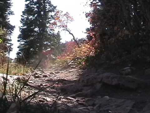
Sweeney Switchbacks, Johns Trail, 4:20, GravediggerThe Park City Town Loop is a dang good ride but it's for expert-level riders. The loop was
published as a "classic ride" over 25 years ago. The Town Loop loop links the Sweeney Switchbacks,
John's, and Gravedigger trails for a nice taste of Park City riding without spending all day.
It's upper-intermediate with a few slightly technical spots that raise the rating to expert.
Overall climbing 1200 feet.
There's 7 miles on dirt, of which 5 is high-quality forested singletrack. There's a couple
of miles of doubletrack that tie it together. Overall climbing on this
loop is around 1300
feet.

Pedaling through an aspen forest on Sweeney's Switchbacks.

Getting steeper and rockier as we climb higher. Lower Sweeney's is plush; upper Sweeney's requires expert skills to stay on your bike.
Because this loop has a top elevation of 8100 feet, it's ready to ride a bit earlier than trails
on the upper slope. The expected riding season will be early June through
October.

The Treasure Hill trailhead. The doubletrack is the Sweeney Connector. Treasure Hill is 100 feet uphill on your right.
Treasure Hill TrailheadThis small trailhead, with room for 5 cars, is located on the southern end
of Lowell Avenue 1/2 mile south of the main PCMR parking. You'll need to
climb uphill on Sweeney's Switchbacks or a combination of Treasure Hill
and Sweeney's. Then keep straight (left and downhill) onto South Sweeney
at mile 1.2 from the Treasure Hill trailhead. South Sweeney will cross
Mother Urban after another 0.1 miles.
Do not park on residential streets! If the Treasure Hill Trailhead is
full, drive to the main PCMR parking and pedal uphill 1/2 mile via Lowell Avenue.

The entry into South Sweeney's from Norfolk Avenue.
South Sweeney's SwitchbacksYou can reach South Sweeney's by taking the Sweeney Connector 0.3 miles
south from Treasure Hill's trailhead then keeping straight onto South
Sweeney's where you'll climb 0.7 miles to intercept Mother Urban.
You can also enter South Sweeney from paved streets at Norfolk Avenue
(there's no parking here). Or, you can hit South Sweeney from a short
connector at King Road's first left-hand turn above the city.

Just getting started. We're just uphill from the doubletrack Sweeney Connector as we begin Sweeney's Switchbacks.
Sweeney's Switchbacks are reached by riding the doubletrack 0.3 miles south from the Treasure
Hill trailhead on Lowell Avenue, then taking a hard right turn uphill
on the singletrack. (Alternately,
you can climb the 1/2-mile Treasure Hill trail until it intercepts Sweeney's
singletrack shortly
after Sweeney's leaves the doubletrack connector.) At first the climb
is fairly gentle, through
choke cherry, aspen, fir, and a maple or two. This lower part of the trail
has a smooth surface.
Alternate route: South Sweeney'sYou can also climb the switchbacks to the south. Pedal 0.5 miles on the Sweeney Connector.
The doubletrack will become singletrack and begin to climb the hill through
switchbacks.

Looking down at the town at a break in the forest.

Riding on South Sweeney's, an alternative to the classic ride.
At mile 0.4 from the Sweeney singletrack (0.7 from Treasure Hill TH) there's a connector trail
on the left that goes out to King Road. Turn right and keep climbing.
Less than 1/10th mile
uphill, the trail splits. The right fork is an easier route connecting
Sweeney South to Sweeney's.
It will cross Mother Urban, then at mile 1.1 from the trailhead, you can
fork uphill left onto
Sweeney's.
The left fork is quite a bit steeper. It climbs 0.3 miles to join Sweeney's just downhill from
the upper Flat Cable trail fork. On the way, it will cross Mother Urban
twice.
Assuming you took the main Sweeney's Switchback singletrack uphill at mile 0.3 from the trailhead
-- a hard right turn uphill -- you're on the more plush and easy part
of Sweeney's. It will
get nasty later.
At mile 0.4, the Treasure Hill trail will join on your right.

Still smooth and plush with an easy grade as we cross a ski slope.

Twisting through a grove of maples as we approach the trail fork for the bottom of Flat Cable.
Around mile 0.6 a cheater trail will come in to your left uphill, then leave on your right
about 50 feet later.
Enjoy the frequent changes from oak to maple to aspen to fir forest to meadows. Wildflowers
include Wasatch penstemmon, scarlet gilia, and balsamroot.
At mile 0.9, keep left as the Sweeney Cutoff leaves on your right, then again stay left at
the intersection with Flat Cable. Flat Cable is an alternate climbing
route that's less technical
than upper Sweeney's. It will rejoin Sweeney's near the top.

The Flat Cable trail fork, as seen from uphill on Sweeney's.

Continuing uphill on Sweeney's. The trail to the left is the Sweeney South connector.
The next intersection is at mile 1.2 from Treasure Hill TH. Turn to the right uphill. The trail
on the left that angles gently downhill is the easier connector to Sweeney
South.
Here's where the trail begins to get tougher. Not all at once. But as you gain elevation it
will get steadily rockier and rootier.

It's getting steadily rockier, but not too bad yet.

Above the Sweeney South connector, it's steeper and rockier. Pedal-bangs will be common. It's a hard area to climb cleanly.
At mile 1.6, you'll hit the top of Sweeney South. Don't go across to the steep trail straight
ahead -- it's a downhill cheater route and there's no reason to push-a-bike
up.
Instead, turn to the right and take the flat trail out to the meadow, then at mile 1.6 make
a hard left uphill. (The trail straight ahead is the top of Flat Cable.)
At mile 1.8, turn right uphill to continue Sweeney's. The trail straight ahead goes to Johns
Trail and the King Road Connector trail.
Keep straight as a connector from Johns joins on your left. Then at mile 2.0 fork left uphill
as Loose Moose heads over to Jenni's Trail on your right.
At mile 2.1, join the gravel Drift Road heading uphill and pedal 1/3 mile. At the saddle area
at the top, curve left around the lift building to find doubletrack heading
uphill on the left.
That's the way to John's Trail.

The final stretch of Sweeney's heads out to the ski slope then joins Drift Road.

The John's singletrack begins after 0.2 miles of doubletrack.
At the top of Drift Road, you're at mile 2.4 of the ride. Curve around the ski lift to your
left and find doubletrack heading uphill on the far side. That's the way
to John's Trail.
Climb 0.2 miles on the doubletrack, then veer to the right on the singletrack John's Trail.
John's Trail will traverse the south side of the hill through a meadow before entering aspen
forest. It will stay in dense aspen forest for the entire trip down Johns.
This trail bobs and weaves through tight aspens, with more hairpin turns and root maneuvers
than you can count. In the uphill direction, John's give you no chance
to let it roll -- you're
constantly making a move to clear a root, dodge an aspen, or roll a tight
turn. If you're an
advanced rider, the aspen-run is a fun mile, but it's a bit of work. If
you're struggling,
well, think of it as bike-control practice.

Heading east on Johns, working our way toward the aspen forest.

It's rare to have a few feet of straight trail once you get into the aspens of Johns.
John's Trail is considered expert-level technical both uphill and down. But intermediates can
with good bike-control skills can do nicely.
The trail is narrow and twisty, with a tight fit for your handlebars between aspens and no
tolerance for bobbling.
There will be a few banked switchback turns, but most of the turns are quick wiggles as the
trail winds through the trees.
The track is almost constantly bumpy due to aspen roots crossing the trail.

Rolling a tight turn.

The trail dips and twists, with encroaching aspen trunks drawing the tip of your handlebar like a magnet.

The trail is littered with aspen roots. Downhill, it's bumpy. Uphill, it's a challenge to clear some of them. Downhill,

Continuing on downhill.
As you approach the bottom of John's Trail at mile 1.5 from the lift, pass the first connector
to 4:20 on your right. Join the Sweeney's to Johns Connector by turning
right at mile 1.6.
Now keep right as the last bit of Johns descends on your left.
You're now on the 4:20 trail (formerly upper Gravedigger), and at mile 4.0 of the ride.

At the exit of Johns onto 4:20.

The 4:20 trail heads south from the bottom of Johns trail.
The 4:20 trail begins at the bottom of Johns and heads south and downhill. It starts out on
an old road-cut, then drops off to the left as narrow singletrack to descend
through switchbacks.
It connects the bottom of John's (and the top of Sweeney's) to King Road.
The 4:20 trail is 0.4 miles long and will descend just under 100 vertical feet as it heads
towards King Road. It will roll through some nice turns as you drop elevation.

Leaving the old roadcut to ride twisty singletrack in the aspens.

Approaching one of several switchback turns.
At King Road, 4:20 ends in a dusty steep plunge to the road. (I keep expecting them to revise
this for uphill riders, but the chute is still there after 20 years.)
Cross King Road to the
top of Gravedigger. You're now at mile 4.4 from the trailhead.

The entry to Gravedigger from King Road.
Gravedigger begins across the King Road from the bottom of 4:20. It's 1.5 miles long with 150
feet of elevation loss as you head south.
Gravedigger begins in aspen forest and descends 0.2 miles to join the Mother Urban one-way
trail. (This segment becomes two-way.)

Gravedigger begins in beautiful aspen forest.

Heading toward the small canyon on the combined Mother Urban and Gravedigger.
The combined Mother Urban and Gravedigger will traverse into a small valley. Here it will cross
the Moosehouse trail at just under 0.4 miles from King Road.
Keep straight to cross the ravine then veer to the left as you enter the trees. Follow Mother
Urban around the hillside.

This is the correct way to go. Keep straight and cross the rockpile in the ravine.

After the ravine, Gravedigger passes through a tall forest of fir.
When you reach a trail fork at 0.6 miles from King Road, keep left and downhill to stay on
Gravedigger. (Mother Urban forks away to resume climbing uphill.)
Gravedigger offers a different type of technical when it climbs up the rocks and roots, but
it also offers a bit of cruising. The trail exits the shade of the firs
into gambel oak.
Gravedigger descends to the bottom of a canyon where you'll transfer to a dirt road and turn
back northbound. You're at mile 1.5 of Gravedigger; mile 5.9 of the ride.
Instead of going straight back to town on roads, you can follow the trail signs to connect
to Daly Avenue then connect to the singletrack Daily Overlook, then Daly
Bypass as you head
back north. Arriving at the base of King Road, connect back to the trailhead
by city streets.

Down to the oak brush at the bottom of Daly Canyon.

The aspens of John's Trail are a highlight of this loop.
Bottom Line!A relatively tough little ride, but a classic. You'll do three of Park City's oldest trails.

Old hand-drawn map from the previous century!
Ride Notes:
0.0 Head up doubletrack, keep straight at 0.1
0.3 Fork L to climb singletrack (N Sweeney)
N Sweeney Switchbacks
0.85 Keep L uphill as trail joins
1.15 Fork, turn hard R
1.6 R on doubletrack (ignore singletrack across road)
1.7 Fork hard L on singletrack
1.8 Fork R uphill (L= to John's at m4.4)
2.0 Keep left onto gravel road uphill
2.7 Saddle, turn L past Town Lift on singletrack
John's Trail
2.8 Fork, turn R downhill
4.4 Fork R (L=connector from Sweeney's m1.8)
N 40° 38.415' W 111°
30.200'
4.85 Cross road to find singletrack
Gravedigger Trail
5.15 Dump down onto DT, go uphill
5.15 Cross creek onto ST
6.0 Singletrack drops onto road
Follow road around bend
6.2 Drop down L past water tank
6.9 Pavement. At stop sign, angle across to Park Ave.
Turn L just past tram on
8th St., becomes Tram Crescent
At Empire Ave, turn left,
follow curve around to
trailhead
8.2 Back at car
Getting there:On Park City's Main Street, turn towards Park City Mountain Resort on Empire Avenue. Turn left
on Lowell Drive. Keep straight past the resort. When you reach the spot
1/2 mile later where
the road turns around in a loop to become Empire Avenue, the Treasure
Hill trailhead is on
the right. The doubletrack straight ahead is the trail.

Near the Town Lift stand the remains of an old mine building.