

Faulty, One-in-a-Pinion, Juniper Drop, lower Spinal Tap
The Pahvant trails lie on the hillside west of I-70 in Richfield, with singletrack trails ranging from beginner to expert. There are also some ATV trails in the area that are occasionally used by cyclists. This page covers the trails on the upper mountain, above the top of Kiln-It. See the lower Pahvant trail page and the Cottonwood Kids Loop page for information on lower trails. See the Spinal Tap page for more information on that trail.
An out-and-back on One-In-A-Pinion can be easy, but most riders use this simply as a route to Spinal Tap (which is Not An Easy Ride).


Or you can connect to Faulty for the singletrack climb. It's not that hard.

You can drive your car up FR096 to shuttle the downhill routes. This gives you the option of an easy descending route (Faulty, then Kiln-It) or a high-expert route (Spinal Tap).
If you're looking for the easiest possible way to bike to the top, it's the road. From the bottom of FR096, it's 4.1 miles and 1400 vertical feet to the top of Faulty. But really, if you're looking for "easy" you're doing the wrong sport.The Faulty trail is 3.7 miles in length with 600 feet of elevation change. It begins on upper Kiln-It and winds up the hill to One-In-A-Pinion and FR 096 at 6850 feet elevation. When climbing from the bottom, about 1/2 mile from where Kiln-It turns to the left on the ridgeline (with the entry to Cairn-Age), Faulty forks to the right.


The next trail fork comes at mile 3.4 of Faulty. Again it's an alternate line that will rejoin. The right fork is the main trail; left takes you over a nice rock drop before rejoining.


The Faulty trail is an easy descending route. Many young riders combine it with Kiln-It as a shuttled ride, with Mom hauling the bikes back uphill. The Faulty portion of this descent is 3.7 miles with only 600 feet of elevation drop. It extends from FR096 (across from One-in-a-Pinion) down to Kiln-It near the top of Cairn-Age. Faulty is a two-way trail, used for climbing to the top of Spinal Tap, so descending riders must stay aware and YIELD to climbing bikers.


After about 100 yards on the doubletrack, veer right (there's a sign) at the Faulty singletrack. (The ATV route heads over to the edge of Cottonwood Creek Wash.)
The terrain alternates between red and white clay in pinion pine forest with an occasional juniper and short meadows of sage scrub.


Next keep right at mile 2.8 if you're riding fast. The left path rejoins after a close encounter with cliffs. If you decide to go left anyway, slow down. Stop and take in the view, then ride on.
At mile 3.4, keep straight as Faulty joins Kiln-It to continue an easier-level downhill.Juniper Drop descends southeast from Faulty two miles downhill from the ridgeline. It drops 250 vertical feet over 0.6 miles, then goes gently uphill 1/10th mile to end on upper Kiln-It, just 30 feet from its origin on FR096.


One-In-A-Pinion follows the ridgeline south from FR096 at the top of Faulty. The trail is 1.1 miles long with only trivial elevation change -- until it drops down to Spinal Tap. It's a two-way trail with some nice views into the wash. It can be done as an out-and-back, or as a connector to the Spinal Tap downhill-only trail.


Otherwise, drop down the white clay slope until you're cruising in red dirt. Somewhere around here, you started Spinal Tap.


The lower segment of Spinal Tap is a downhill one-way trail that begins at the bottom of One-in-a-Pinion. It requires high-expert skills, so others should turn back. Serious here! This lowest segment of the Spinal Tap trail is 4.5 miles long and drops 1300 feet in elevation. It offers quite a few challenging spots.
Spinal Tap, including the upper and middle segments of this 18-mile, 4000-vertical one-way trail, is discussed in greater detail on the Spinal Tap trail page .
This lower segment of Spinal Tap is a challenging trail. It might "average" an expert rating, but there are a few spots that require high-expert skill. line along the rock.")


Eventually, you'll find yourself on dirt road heading north between the mountain and the freeway. The road ends on FR096 just west of the freeway underpass. To head back uphill, climb the road a bit over 1/2 mile and find Tank Run on your right just above the water tank. It will take you to either Big Red or Kiln-It. (See the lower Pahvant trails page.)
See the dedicated Spinal Tap trail page for more details on this trail.

At the top of Faulty, you can keep left and follow the 2.3-mile ATV trail downhill to the Kiln-It/Cairn-Age intersection. Like many ATV trails, it's loose and often steep, tending to go over small hills instead of around them. Riders are still using this ATV track occasionally, mostly for a few nice views into massive Cottonwood Wash.
Keep right (on top of the ridge) at mile 1.6 where a larger ATV route drops steeply into the wash. Keep heading east. At a fork at mile 1.9, turn left and the track will take you to the top of Cairn-Age. (The right fork takes you steeply uphill to the top of Kiln-It.)

At FR096 mile mile 3.9 (1.4 miles from the top of Kiln-It) an ATV route forks away on the uphill side of a 150-degree right-hand turn. After climbing to a ridge line, it turns and descends east back to the edge of the freeway. There are some confusing spots where ATV tracks join/leave. It's around 4.7 miles to the bottom. Here a left turn on dirt road can take you back to FR 096.I saw no bike tracks on Scorpion at 2 weeks since the last rain. Since Spinal Tap was finished in 2020, almost no bikers ride the ATV trail.
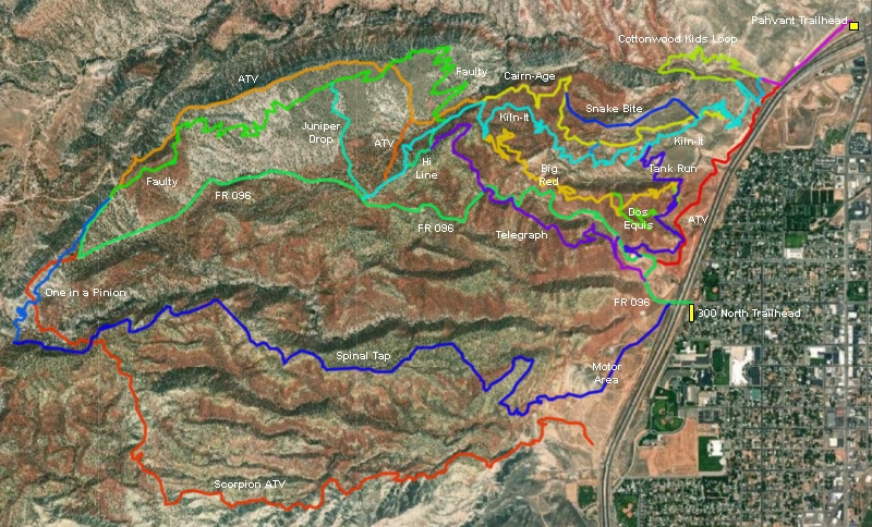
Pahvant (northern access) parking: At the north Richfield exit from I-70, turn north (toward the mountains). As the pavement ends, turn left onto a gravel road, then left again into the Pahvant parking area. Start the ride either on the small gravel road heading southwest parallel to the freeway, or on the singletrack near the trail sign (the two routes will rejoin after 0.3 miles). After 1/2 mile, follow the trail sign by turning right on a smaller gravel ATV track. (Note there's room for a couple of cars here where the doubletrack splits.) Veer left onto singletrack after 0.1 mile to head for Kiln-It, or continue uphill on the doubletrack for the Cottonwood Kids Loop.
300 North (FR 096) parking: From Richfield's Main Street, turn west on 300 North. As you approach the freeway, turn left into the ATV parking lot. Pedal under I-70 to head uphill on FR096 to reach the top of Kiln-It.
Shuttle: Top of Kiln-It: Drive uphill on FR 096 2.2 miles and find DT on your right with a carsonite trail marker. Top of Faulty: continue to mile 4.1 of FR096 and find marked ATV track on the right, with singletrack across the road on the left.
Bathrooms and water: none at trailheads (businesses nearby)
GPS track files and route (right-click and "Save as..."):
Multi-track area file
Map to save or for printing in new window: 2021 map
Lodging, camping, shops:
Links to Cedar City area resources
Bryce area


