North 40 (includes Maverick)
Brand Trails System, Moab
The North 40 mountain bike trail is located within the Bar M loop just north of Moab. It's part of the Brand Trails mountain bike trail complex. North 40 forms a loop (with an optional short connector that converts to loop to figure-8) that's 4.2 miles long. The ride is early-intermediate technical. Of the rides in the area, it's harder than Lazy-EZ but much easier than Deadmans or Bar B.
The trailhead is across from the Lazy-EZ loop trail just east of the main parking area. (Note: this refers to the new cyclist parking area, not the restaurant parking strip you pass on the way.) To reach the trail, pedal east 0.2 miles and turn left at the sign.


The biking trail is 90% dirt singletrack, with occasional slickrock and periodic rock humps. I found it to be a dab-free cruiser. There's nothing hairy, so experienced beginners could try this ride without fear. But I'd encourage beginners to do Lazy-EZ first, because North 40 is relatively narrow with many rock-lined spots.
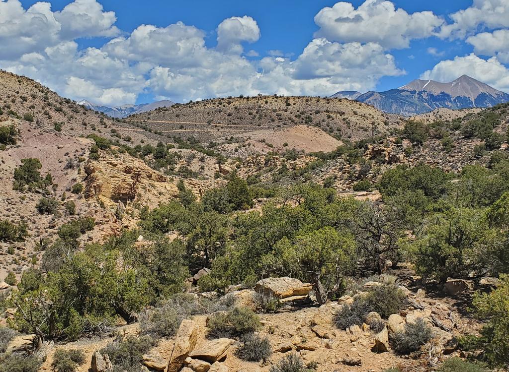
The trail rapidly climbs up to a ridge. There's only about 50 feet of absolute elevation change. Your total climbing will be 200 feet. This is a ride you can do quickly as a late-afternoon arrival ride, morning warmup, or a legs-dead-quickie to finish your day.


From the ridge, there are nice views of the cliffs to the west of Highway 191. Moenkopi skirts give way to the banded Chinle formation, topped by vertical cliffs of the Wingate formation. Morning is the best time for seeing the views. (By afternoon, the cliffs are just dark shadows.)
The trail just opened in late winter 2012. In late March, most of the trail was nicely packed. A couple of spots still need more bike tires or a little berming work to ride well. There were two spots requiring a quick turn in dirt where the surface simply gave way. These will probably be worked-in by the time you ride.


While most of the trail is sit-and-crank, there are some out-of-the-saddle spots. Make sure any beginners riding with you have experience at standing on the pedals while the bike moves underneath them.
The trail can be done either direction. There's a short cross-over at the north end that can convert the loop to a figure-eight. If riding clockwise, the crossover is at mile 1.1. Counterclockwise, it's at 2.1 miles.


The rocky areas are marked with baby-blue paint spots on the rock. I found the route very easy to follow, with never any doubt about where to steer the bike.
Maverick Option
The Maverick Trail is a 0.5-mile alternate route on the eastern side of North 40. It's one-way from north to south. When riding clockwise, you find the trail fork at mile 3.4 miles from the North 40 trailhead (mile 3.6 from the parking lot). Note: if you take Maverick, you'll bypass the section of North 40 containing the O-to-40 connector. See below.


Maverick is new in late fall 2012. It's a twisting high-speed dirt ribbon. It rejoins North 40 about 1/10 mile from the loop split.
At the far east side just 0.1 miles south of the Maverick fork, there's a fork that connects to the east side of the Bar M loop. It joins right at the beginning of the Circle O. It's at 3.5 miles when riding clockwise (0.7 miles counterclockwise). This fork will be popular among riders looking for a long ride. Rather than returning to the North 40 trailhead, you'll zip directly to the Circle O.


Longer early-intermediate or beginner rides:
North 40 plus Circle O. From North 40 proceed to
Circle O
with a return via
Bar
M.
(
Rockin A
is too tough for most intermediates in the north-to-south direction.)
Another nice option is a bow-tie shaped ride, made by combining the
Lazy-EZ
loop to North 40 loop.
Tougher rides:
A satisfying ride for strong intermediates or advanced riders would be to finish North 40, then complete a loop via Circle O, Rockin A, Bar B, Deadmans Ridge, then EZ. The ride below is 12 miles, but it can be a lot longer if you (1) complete North 40 and (2) do the entire Bar B loop before connecting to Deadmans.


Continuing from North 40:
Circle O
is a relatively easy 100% slickrock ride. Pretend you're playing Mario Cart and the stain strip
is how you get fuel, win fruit or points, whatever. After three miles
on the Circle O, you'll
come to the junction with Rockin A.
Now go to Rockin A.
Rockin A
is challenging in the north-to-south direction. In addition to the up-and-down technical features
which are much tougher in that direction, you'll gain 150 vertical feet
over the 1.7 miles.


Rockin A now has three types of marking: the traditional red A on a rocker (based on a cattle brand), a suggested riding stripe of stain, and yellow paint stripes. Sometimes these will diverge slightly, but you can't get lost.
Rockin A ends at the Bar B, just past the southern end of the Bar M loop. If you intend to add the Bar B, turn left. For the 12-mile version, go straight and uphill on the Bar B singletrack. Keep right at the first fork 0.1 mile later (left is the return from the Bar B loop). After another 0.1 mile, you'll reach junction with Deadmans Ridge. Again, keep right. (Left is the southbound half of Deadmans, which descends to the Old 191 paved trail.)


Deadman's Ridge is a fun upper-intermediate to advanced-tech ride. As you reach the end, select either Lazy (to your right) or EZ (to your left) to head back to the trailhead.
0.0 From valley parking, east on DT
N38 39.106 W109 40.111
0.2 L on North 40 ST
N38 39.200 W109 39.995
0.3 Keep L for clockwise ride
N38 39.263 W109 40.013
1.3 Keep L (R = crossover)
N38 39.768 W109 40.608
2.3 Keep L (R = crossover)
N38 39.774 W109 40.584
3.6 Keep L (R = Maverick)
N38 39.630 W109 40.017
3.7 Keep R (L = to Bar M, Circle O)
N38 39.568 W109 39.975
Keep R again at 3.8
4.3 Keep L (R = Maverick return)
N38 39.403 W109 40.028
4.4 L (loop finished)
N38 39.263 W109 40.013
4.5 L on DT
N38 39.106 W109 40.111
4.6 Back at parking
0.0 From valley parking, east on DT
N38 39.106 W109 40.111
0.2 L on North 40 ST
N38 39.200 W109 39.995
0.3 Keep L for clockwise ride
N38 39.263 W109 40.013
1.3 Keep L (R = crossover)
N38 39.768 W109 40.608
2.3 Keep L (R = crossover)
N38 39.774 W109 40.584
3.6 Keep L (R = Maverick)
N38 39.630 W109 40.017
3.7 L and L on O-to-40 connector
N38 39.568 W109 39.975
3.9 Cross Bar M N38 39.641 W109 39.861
4.1 L onto slickrock Circle O
N38 39.713 W109 39.689
6.7 Continue to Rockin A (keep L)
N38 39.166 W109 38.907
8.5 Cross over to climb Bar B ST
N38 38.272 W109 38.489
8.6 Keep R on Connector
N38 38.261 W109 38.592
8.7 Keep R on Deadman's
N38 38.253 W109 38.683
10.4 L onto EZ
N38 38.573 W109 39.279
10.6 Keep R (north)
N38 38.516 W109 39.403
11.8 L for TH (R = Lazy)
N38 39.166 W109 39.856
11.9 L on DT downhill
N38 39.187 W109 39.989
12.0 Back at parking

Getting there:
From I-70, drive south on US-191 for 22 miles. From Moab, drive 7 miles north from the Colorado River on 191. When you see the Gemini Bridges parking area on the west side of 191 (on the side with the cliffs), look for the Bar M gravel entry road on the opposite side (east, away from the cliffs). Turn onto the gravel road and immediately go right. Drive past the first restaurant parking area. Continue south to the spot where the fence separates the road from the paved bike trail and turn 90 degrees left. Descend to the new parking spot in the valley. Begin the ride by pedaling 0.2 miles east and find the North 40 trailhead on the left.
Riding resources for this trail:
Single-page riding guide
GPS track files (right-click and "Save as..."):
North 40 only
Maverick only
North 40 -
Circle O - Rockin A - Deadmans Loop
(12 mi)
Complete
North 40 then loop 14 mi
GPX file all Moab Brand area
trails
Topo including all Brand Trails:
View
Lodging, camping, shops:
Links to Moab area resources