View east toward the Wasatch Range from upper Mercer Hollow. Original review and ride description by Bruce on September 20, 2016. Latest update October 2019.
Mercer Hollow
with Mercer Mountain and Two HollowsThese trails lie on the southern slope of Traverse Mountain, just across Traverse Ridge
from the
Corner Canyon
trails. The Mercer
Hollow trail runs through a shallow valley, connecting two spots on
Suncrest Drive. It joins the bottom of Two Hollows about half-way down
then continues on as doubletrack along the utility corridor.
Mercer Mountain forks off Mercer Hollow at the top and descends around
the hill to the Two Hollows trail. Two Hollows climbs into
Hog Hollow
for connections to
Peak View
or
Alpine
.

View over my Rocky Mountain's handlebars as the Mercer Hollow trail drops off Suncrest Drive.

All three trails are two-directional, and are good climbing routes. This opens many different riding combinations.
Two Hollows follows a pipeline corridor from the subdivision, crossing from Hog Hollow into
Mercer Hollow. It was completed in spring 2018. Two Hollows is very easy
pedaling, with a gradual
gradient.
Mercer Hollow and Mercer Mountain are easier-intermediate in technical
requirement. Mercer Hollow was cut in 2016. Combined with a reworking
of
Eagle Crest
and
South
Maple
Hollow
, this began Draper City's development of their southern
trail system, which includes
Vertigo and Levitate
.
Mercer Mountain was completed
in spring 2018.

Descending Mercer Mountain toward Two Hollows, with Lone Peak in the background.

View south, with Utah Lake in the distance.
On these south-facing slopes at foothill altitude, the
riding season is mid April through November. But if you're planning an
extended ride in early spring, the trails on the north side of Traverse
Mountain (such as
Rush
,
Ann's
,
and
Canyon Hollow
) may still be muddy when
this trail is dry. The sample ride listed below uses only trails on the
southern slope.

Looking east. The notch in the mountains is American Fork Canyon.
The Mercer Hollow trail is 2.0 miles long, about half singletrack and half doubletrack with
500 feet of elevation change. Both ends are on the east side of Suncrest
Drive. The upper end
is where the sort-of-flat terrain of Traverse Ridge gives way to the slope
of Mercer Hollow.
There's no formal parking at the top, but riders can find a spot nearby
where they can wedge
their vehicle between the road and the oak brush.
The downhill end is just east of the Mercer Hollow subdivision. There's a wide spot off the
road with enough room to leave a car or two if you're using the trail's
bottom as your starting
point. Or if you're doing shuttled laps.
At the top, the Mercer Hollow trail begins on the east side of Suncrest Drive at 5950 feet
elevation, 1/2 mile downhill from the 4-way stop at the summit. (See the
directions near the
page bottom.) Look for the fire hydrant just below the new eastbound road
(under construction
in 2016) on Traverse Ridge. This is about 100 yards uphill -- and across
the road -- from the
eastern end of the
Eagle Crest
trail.

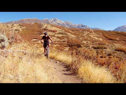
Looking south as I climb the Mercer Hollow singletrack. There are a lot of swoops in the trail. These are great fun but they also keep water from channeling on the trail and washing it out.

The terrain is small stands of gambel oak in grassy meadows with occasional sage brush. We're looking northeast.
The first 1.1 miles is swooping twisting singletrack that drops 300 vertical feet as it descends
southbound. but it won't be 100% descending. Most of the uphill bits are
very short grade reversals
to help the trail shed water, and you'll just roll right over them. But
there are a couple
of spots where you'll need to pedal.
The trail's riding platform is broad and smooth, with no significant bang-over rocks. Turns
are highly banked for speed. While most riders will love descending this
trail, it's also an
easy climb. I passed a couple of uphill-bound warriors in full battle
armor riding DH bikes,
and they weren't working too hard.

Little Rocky rests on the berm of a turn. Nice thinking, trailbuilders, placing the rocks so dipwads don't cut across the turn.

Heading northeast toward the far side of Mercer Hollow, with Lone Peak on the skyline.
At the first southward turn or the trail, Mercer Mountain forks away to the left. Keep right
for the Mercer Hollow descent. The trail will cross over to the east side
of Mercer Hollow,
then back to the west side. At mile 1.1, the singletrack ends on a narrow
cindered road. At
this spot, you can turn right (uphill) to head for the paved neighborhood
street, or go across
to the doubletrack to resume descending.
Shortly afterward, the Two Hollows joins the doubletrack on your left. The doubletrack portion
of Mercer Hollow is 0.9 miles long, dropping another 200 feet. It will
hit Suncrest Drive at
a chain-link fence gate (with a couple of heavy-construction tires alongside
in 2016).

Approaching the trail fork, with Timpanogos in the background. Right for Mercer Hollow; straight (left) for Mercer Mountain. This trail reviewed May 6, 2018.
The Mercer Mountain trail is 1.1 miles long. It's twisting curving singletrack, good as either
a climbing or descending route. There's a surprising amount of swooping
and whooping for a
machine-built trail.
The western end starts on Mercer Hollow, just as the trail turns to the right southbound in
the first major turn. It runs generally southeast. There's 200 feet of
elevation loss over
the course of the trail.
The terrain is oak brush. Although on a southern slope, the trail doesn't dry until May.
Mercer Mountain provides a connection
from the top of Mercer Hollow to
Hog Hollow and Porcupine
further east on Traverse Mountain. The eastern (downhill) end of Mercer Mountain
lies on the
Two Hollows trail. Two Hollows climbs slowly to combine with Hog Hollow
about
1/10th mile downhill from the Porcupine trail.

Riders arrive at the bottom of Mercer Mountain.

The trail is twisty and swoopy. Good riding both uphill and down.
The combination of Mercer Hollow, Two Hollows, and Mercer Mountain makes a nice little triangle
loop ride. If you start from the Peak View trailhead, climb over to Porcupine,
then connect
to this loop via Two Hollows, it's 8.0 miles with 950 vertical feet of
climbing.

Rocky Mountain Element on Mercer Mountain with Lone Peak in the distance.

Heading around the ridge from Mercer Hollow into the Hog Hollow drainage. On the left, Timpanogos looks over the lower hills formed of the scarps of the Wasatch fault.
Mercer Mountain is also your connection from
Eagle
Crest
to Alpine. Hog Hollow drops down to west Alpine and the
Hog Hollow
Creek
singletrack. Uphill on Hog Hollow, the Porcupine trail takes you to Peak View, where a right
(uphill) turn takes you eastbound to the
Three
Falls
trail. Three Falls has a connecting trail to a trailhead in Fort Canyon, plus an
eastward extension to Alpine Cove
near Schoolhouse Springs (where you can hop on pavement to
Lambert Park
).

Almost to the bottom.

Looking south toward Mount Timpanogos on Two Hollows
Two Hollows follows a sewer corridor. When converted to a trail in 2018, it's a broad path
but will narrow with time. It's a critical piece of the navigation, as
it connects the Mercer
trails to Hog Hollow (for connections uphill and eastbound).
The trail is 2.3 miles long, with 550 feet of elevation change.
On the uphill end, the trail begins on Canyon Pointe Road at an altitude of 5800 feet, about
1/4 mile from Suncrest Drive. Access is on the northern side of the road,
with an underpass
taking you to the downhill run into Hog Hollow. As you exit the underpass,
veer left.Tthe singletrack
entry to
Achtung Baby
is on your right.
At mile 0.4 from the top, the
Porcupine
trail is on your left. It
climbs up to Peak View. (Across from Porcupine is an exit from Achtung
Baby.) At mile 0.5, the trail splits. The more steep
trail on the left is Hog Hollow. The broad route on the right is Two
Hollows.

Underpass from downhill. When climbing, fork left as you exit to climb up to the road.

The viewpoint on Two Hollows, across from Mercer Mountain's downhill end.
Just 100 yards downhill from the Hog Hollow trail fork, the
Achtung
Baby
trail joins on your right, then in a few feet it forks away on the left. This downhill flow
trail drops to Hog Hollow in the lower canyon, for a nice little loop
add-on while you're in
the area.
Continuing downhill on Two Hollows, at mile 1.1 there's a turnout with a viewing area. Take
a minute to admire Utah Valley. Directly opposite the turnout, the Mercer
Mountain trail begins
its uphill climb on your right.
From the Mercer Mountain fork, Two Hollows curves around the hill and drops into Mercer Hollow.
It joins the Mercer Hollow doubletrack -- which is the continuation of
the pipeline corridor
-- just below the end of the singletrack. If you're riding a loop with
Mercer Hollow, turn
right uphill on the doubletrack and climb 100 yards to the singletrack.

The Two Hollows trail turns north as it descends to the bottom of Mercer Hollow.
Sample ride... Loop around Mercer trails with Two Hollows - from Peak
View TH

Riding Mercer Hollow.
This ride is 8.0 miles with 950 feet of total climbing. It starts from the Peak View trailhead
-- so you've got to get there first. Which as of spring 2018, you can't
do via your car. (The
closest access is at the end of Canyon Pointe Road in the subdivision.
A doubletrack takes
you 1/3 mile to the trailhead.)
This is a lariat ride, but you can do the loop either direction. Climb Peak View to Porcupine
and descend to Two Hollows. At the bottom of Two Hollows, fork uphill
on Mercer Hollow and
climb to the top. Then fork onto Mercer Mountain and take a swooping descent
to Two Hollows.
Now make the climb back up and over to the trailhead.
0.0 Through south fence to Peak View trail
N40 29.285 W111 49.233
0.6 R on Porcupine N40 29.286 W111 48.877
1.5 Hard L downhill on Two Hollows
N40 28.929 W111 49.026
1.6 Keep R (L = Hog Hollow)
N40 28.898 W111 48.912
2.3 Viewpoint on L (Mercer Mtn on R)
N40 28.493 W111 48.690
3.5 Hard R uphill on Mercer Hollow DT
N40 28.327 W111 49.224
3.6 Cross DT to ST Mercer Hollow
N40 28.347 W111 49.257
4.6 Hard R on Mercer Mtn N40 28.723 W111 49.372
5.7 Straight onto Two Hollows N40 28.502 W111 48.687
6.4 R on Porcupine N40 29.286 W111 48.877
7.3 Straight onto Peak View N40 29.286 W111 48.877
8.0 Back at TH
Sample ride... South-side loop ride with Maple
Hollow

Descending the eastern side of Mercer Hollow.
For the loop ride using
South Maple Hollow
and
Eagle Crest
, turn uphill and crank west
up Suncrest Drive in the bike lane. At the first side-street on the left,
cross over to Brooklings Drive.
Follow Brooklings to the first street on the right. Jog right-left to Brookside Drive and continue
uphill to the end of the road to catch the new singletrack on the left.
At the trail fork about
1/2 mile uphill, keep to the right and uphill to continue climbing. (The
left fork takes you
down to the flood-control dam. Uphill from the "pond" is the hiking singletrack
uphill.)
Riding notes, clockwise south side loop
from Maple Hollow TH:
0.0 L south downhill to underpass
N40 28.542 W111 51.056
0.1 L on Eagle Crest N40 28.489 W111 50.993
0.3 Keep R (L = to road) N40 28.519 W111 50.824
0.5 Keep L (R = Maple Hollow connector)
N40 28.394 W111 50.715
1.0 L uphill on DT N40 28.350 W111 50.255
100 ft R on ST
1.2 Skirt trailhead fence to south end
N40 28.354 W111 50.174
2.5 Suncrest Drive, cross N40 28.692 W111 49.402
Uphill 150 feet, L singletrack
Mercer Hollow
N40 28.726 W111 49.453
3.6 Cross cindered DT to DT southbound
N40 28.347 W111 49.257
4.6 R on Suncrest Drive N40 27.694 W111 49.095
4.8 L to Brooklings Drive N40 27.696 W111 49.329
5.4 1st L uphill (Acre Lane)
N40 27.610 W111 49.915
200 feet then L on Brookside
Dr.
5.7 L onto ST Maple Hollow South
N40 27.726 W111 50.220
6.4 R uphill (L = down to DT and dam)
N40 28.042 W111 50.588
6.8 R (L = old descending trail)
N40 28.291 W111 50.758
6.9 L on South Maple Hollow (R = connector)
N40 28.360 W111 50.718
7.4 Straight and through underpass
7.5 Back at parking

Map of Maple Hollow area.
Getting there: From I-15
in Salt Lake City, take the Bluffdale exit and head east on Highland Drive
toward the mountains. As you reach the traffic light at the top of the
hill, about 3/4 mile after leaving the freeway, turn right on Traverse
Ridge Road. Drive about two miles up to the top of the mountain to the
stop sign.
From Utah County, get on the Timpanogos Highway. At the Lehi-Highland
border, go north on Highland Blvd at the big stop light east of Smiths.
This will become Suncrest Drive as it enters Draper. Climb to the stop
sign at the top of the hill.
Deer Ridge (Maple Hollow) trailhead: At the
stop sign in Suncrest, get on Deer Ridge Drive (right turn from SLC,
straight from Utah Co). Go 0.9 miles.
Just before the road crosses a bridge, turn right onto Elk Glen Drive and
immediately turn left to park at the small picnic area.
Eagle Crest trailhead: From the hill-top stop sign above, go
south on Traverse Ridge Road (straight from SLC, left turn from Utah Co).
To to the end of the road and park.
Top of Mercer Hollow: There is some roadside parking off Suncrest Drive near the top of the trail,
on the east side of the road 1/2 mile downhill from the four-way stop in
Suncrest. But there are some cautions. In 2016 this is an active
construction area, so be sure you're not in an access-point or work zone!
Bottom of Mercer Hollow: There's room for 3 or 4 cars at the
bottom of the doubletrack portion of Mercer Hollow on Suncrest Drive.
Brookside Drive: Brookside Drive turns to the west off
Suncrest Drive, just uphill from the Maple Hollow subdivision. Drive past
the homes and uphill to the end of the road. The South Maple Hollow trail
is on the west side of the road. It will take you uphill, where you can
connect to the Eagle Crest trail (or cross over the ridge to Ann's
Connector).