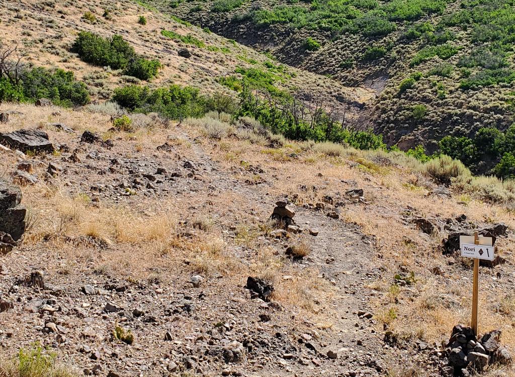

View south down the canyon. Review and photos by Bruce on July 21, 2023.
Maple Grove Trail
Riding option off the WoW trail in Pine Canyon
The Maple Grove trail is a two-mile trail from Highway 222 (Pine Canyon road) to the middle of the WoW trail in Pine Canyon north of Midway. It can be done as a stand-alone out-and-back ride, or as part of a WoW ride. This trail creates the option of a shorter loop ride using the road, or a lower-elevation shuttled ride when the upper part of WoW is not ready.
The Maple Grove trail has its own primitive trailhead on the east side of SR 222, around 100 yards from the road. The trail starts on the west side of the road. The Maple Grove trail lies at around 7000 feet elevation. The expected riding season will be June through October. When done from SR 222 to WoW, Maple Grove has 350 vertical feet of climbing and a bit over 200 feet of descending.

Climbing through a mixed forest on the western side of the trail.
Trailhead and Connections

Looking north from the entry road to the parking for Maple Grove.
Maple Grove trailhead
Drive past the Pine Canyon Bike Park parking and the campground entry. At the Pine Canyon (lower WoW) trailhead, zero your odometer. The Maple Grove trailhead is a primitive parking area just off SR 222 at exactly mile 2.0 from the lower trailhead. The dirt-road entry to the parking area is directly across from the singletrack trail.

In the parking lot of the SR 222 trailhead, looking south (down canyon) at the fee station. WoW is across the road.
Lower WoW (Pine Canyon) trailhead
This is the main trailhead for the canyon trails, and is where almost everybody sticks their shuttle vehicles. Look for it on your right about 1/4 mile after you pass the campground entry. Head for Maple Grove via either WoW or SR 222. When climbing WoW, you'll reach the fork for Maple Grove after 4.5 miles and 1150 vertical feet of climbing.

Looking south at the entry to the top of the WoW trail.
Upper WoW trailhead
This trailhead is on the left side of the road, 4.5 miles uphill from the lower trailhead. It's 6 miles from the upper trailhead to the Maple Grove fork, where you'll need to make a sharp 160-degree left turn.
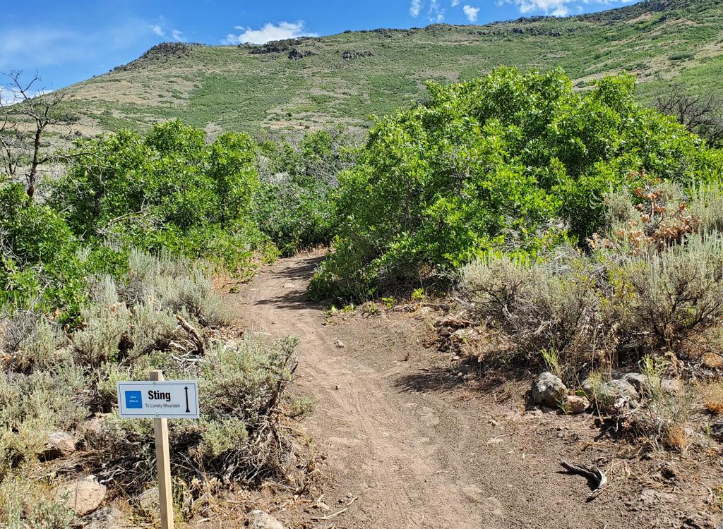
The Maple Grove Trail

At SR 202, the trail starts as a barely-visible ribbon in tall grass.
The Maple Grove trail is exactly 2.0 miles long. On the eastern end at SR 222, the elevation is around 7150 feet; at the junction with WoW it's 7350. When done east-to-west from the highway to WoW, there will be 350 feet of climbing and 200 of descending.
Starting from SR 222, the trail rapidly enters an aspen and maple forest. As it curves around to south-facing slopes, the trees change to tall gambel oak for a short while, then revert to maple and aspen. As you climb toward WoW, the forest becomes mature fir.

Some parts are dry oak, other areas are lush.

View south in a maple forest early in the east-to-west ride.
West-to-east (from WoW to the paved road) is a considerably easier direction to ride, not just because of the relative climbing and descending. There are a few short but steeper pitches that are uphill when riding toward WoW, but downhill when going west to east.
A loop starting at the lower WoW trailhead, climbing SR 222, then riding Maple Grove over to WoW and descending, will be 8.5 miles with 1300 feet of climbing.

Looking over the oak brush at the opposite hillside.

At this spot, we've finished descending. It will be a steady climb for the next mile, with around 350 feet of elevation to gain.
When making the loop ride via SR 222, the climb is fairly steady. There will be a few steeper granny-gear areas that will slow you to walking pace. Overall, you'll gain 900 feet of elevation over the two-mile climb.
The entry to Maple Grove is around 1/4 mile above the first set of sharp switchbacks in the road. There's a dirt road on the right that goes 100 yards to a primitive parking area. The singletrack is on the left, invisible to the cars that drive past.

Not all of the western side is in forest. There will be occasional breakouts of low scrub, where you can take in the views to the south.

Bruce climbs through fir forest. The western half has a higher rock-to-dirt ratio.
Once on Maple Grove, there's a short gentle southbound climb before the trail descends gently to the northwest. At mile 1.0, the trail enters a forest of maple, aspen, and fir and turns south again.
There will be occasional views down the canyon toward Midway as the trail passes in and out of forest. As you approach WoW, the firs trees become dominant and you enter a forest of mature conifers.

Almost there. The trail undulates southbound just below a ridgeline as it approaches WoW.

Bruce hits the final pitch of Maple Grove to join WoW. (We're looking staright up WoW.)
Maple Grove joins WoW at a trail merger that would send you downhill on WoW. Most riders will be using this trail east-to-west as part of a lower-mountain WoW ride.

Aerial map of WoW showing Maple Grove.
Getting there, Pine Canyon (SR-222) trailhead: From Provo Canyon, drive east to the end of Deer Creek Reservoir. Right where the water ends, turn left (north) on U-113. Zero your odometer. Drive north 3.8 miles into Midway. On Main Street, turn left (west) onto Highway 222. Follow the signs for Wasatch Mountain State Park and/or for Guardsman Pass, staying on 222 as below. When you pass the campground (on your left), watch for a gravel pull-out area outlined by large boulders on the right side of the road about 1/4 mile later. The trail starts across the road from this parking spot.
From Salt Lake City, go up Parleys Canyon on I-80, then turn right (south) on US-40. Drive all the way into the middle of Heber, then at 100 South turn right on SR 113 to Midway. In Midway, continue straight as SR 113 turns south, and you'll be on SR 222. Go 2 blocks to 200 East and turn right. Turn left at 200 North and go about 1/2 mile west and SR 222 will turn right to be northbound again. When the road turns west, turn right to stay east of the golf course on 222. Once you pass the campground, look for the parking area on the right about 1/4 mile uphill.
Maple Grove trailhead: Drive exactly two miles uphill from the lower WoW parking (not the bike park parking lot). Turn right on a dirt road and park in the cleared area 100 yards later.
Upper WoW trailhead: Continue on 222 uphill to mile 4.5 from the lower trailhead, then turn left and descend to the large fenced parking area. The trail starts on the south (down-canyon) side of the parking area, directly downhill and across the parking lot from the entry road.