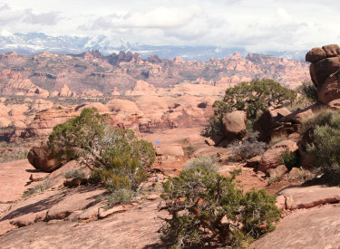
Klondike Bluffs mountain biking area
The Malachite and Azurite trails are new additions to the Klondike Bluffs mountain biking area . These short trails offer an extended loop option when riding Miner's Loop , or an alternate route to upper Baby Steps for access to the upper mountain. The trails lie at around 4900 feet elevation, with a riding season of mid-March through November.
For short rides, the trails are quick to reach from the south Klondike trailhead. The ride detailed below is 6 miles, and is the shortest path that can hit these trails.


When climbing Miner's Loop in the recommended counter-clockwise direction, the Azurite trail is reached at exactly one mile from the loop's start. The Azurite trail is 1.2 miles long, ending on the Malachite trail just before Malachite reaches Baby Steps. There's 50 feet of absolute elevation gain when ridden south to north. A dip through a wide ravine brings the overall climbing to just over 150 vertical feet south to north.


The trail is named for the blue gemstone azurite, a form of copper carbonate hydroxide. (There are multiple small inactive copper mines in the Klondike area , including the one you saw from Miner's Loop. While I didn't see any azurite along the trail, bits can be found in the mine tailings.)


At its bottom (southwest) end, the Malachite Trail begins on Miner's Loop , about 0.2 miles from Azurite. This trail is significantly more technical than Azurite. It extends 0.9 miles from Miner's Loop to Baby Steps . While there's only a little elevation gain south-to-north, the trail dips through a valley, making the overall climbing around 200 vertical feet.
Green is the color of the mineral malachite, also a form of copper carbonate hydroxide. (Malachite has a 2 to 1 ratio of copper to carbonate, while azurite has a 3 to 2 ratio.) Azurite and malachite form where copper ore is exposed to oxidation, and are often found jumbled into the same rock.


Bottom Line!
Short trails with fun riding and nice views, creating new route options for either destination
rides (Baby Steps) or just puttering around.
0.0 L to Inside Passage ST
N38 46.429 W109 42.764
0.4 Join DT (Klondike)
N38 46.686 W109 42.900
0.7 Stay R on DT (L = Jurassic)
N38 46.869 W109 43.064
0.9 Straight to ST (Dino Flow) as road forks
N38 46.997 W109 43.072
1.0 R on EKG N38 47.116 W109 42.981
1.2 R to Miner's Loop
N38 47.169 W109 42.943
1.25 Keep R as loop forks
N38 47.174 W109 42.916
N38 47.419 W109 42.449
3.4 L on Malachite
N38 47.792 W109 42.664
4.1 R on Miner's Loop
N38 47.496 W109 42.540
4.9 Keep straight (R), close loop
N38 47.174 W109 42.916
5.0 L on EKG N38 47.496 W109 42.540
5.1 L on Dino Flow N38 47.116 W109 42.981
5.2 Straight on DT N38 46.997 W109 43.072
5.7 R on Inside Passage N38 46.686 W109 42.900
6.1 Back at parking

Water: None
Toilet: Dinosaur Tracks parking
Camping: Not here
Information: Moab visitor's center
Chilkoot Pass parking: 1.2 miles from the highway as the road is heading east toward the bluff, the first parking zone is on your right. This is the Chilkoot Pass trail.
Agate trail parking: Continue a few feet past the Chilkoot parking. Fork right on a fainter jeep road N38 49.103 W109 46.061, as the main road continues to the dinosaur tracks. At mile 1.6, you'll come to the TH for the Jasper and Agate loops (N38 49.087 W109 45.625) on your right.
Mega Steps parking: Keep going past Agate. At 2.0 miles, you're at the bottom of Mega Steps at a larger parking area N38 49.179 W109 45.417.
Dinosaur Tracks parking: From 191, stay on the main Dinosaur Tracks road. At the road fork at mile 1.2 above, keep left on the main road toward the dinosaur tracks. About 1/2 mile further, turn to the right into the parking area. The Dino Flow trail is up against the mountain, to the left of the pit toilet.
Single-page riding guide, short loop from south trailhead
GPS track files (right-click and "Save as..."):
6-mile ride from south trailhead
Multi-track GPX Klondike area trails
14 mile EKG - Miner's Loop plus Azurite/Malachite - Dino Loop
High-res topo for printing: View Klondike area
Lodging, camping, shops: Links to Moab area resources