Looking       southeast while riding the upper elevations of Mahogany Ridge. Review by       Bruce on June 17, 2025.
Looking southeast while riding the upper elevations of Mahogany Ridge. Review by Bruce on June 17, 2025.
Mahogany Ridge

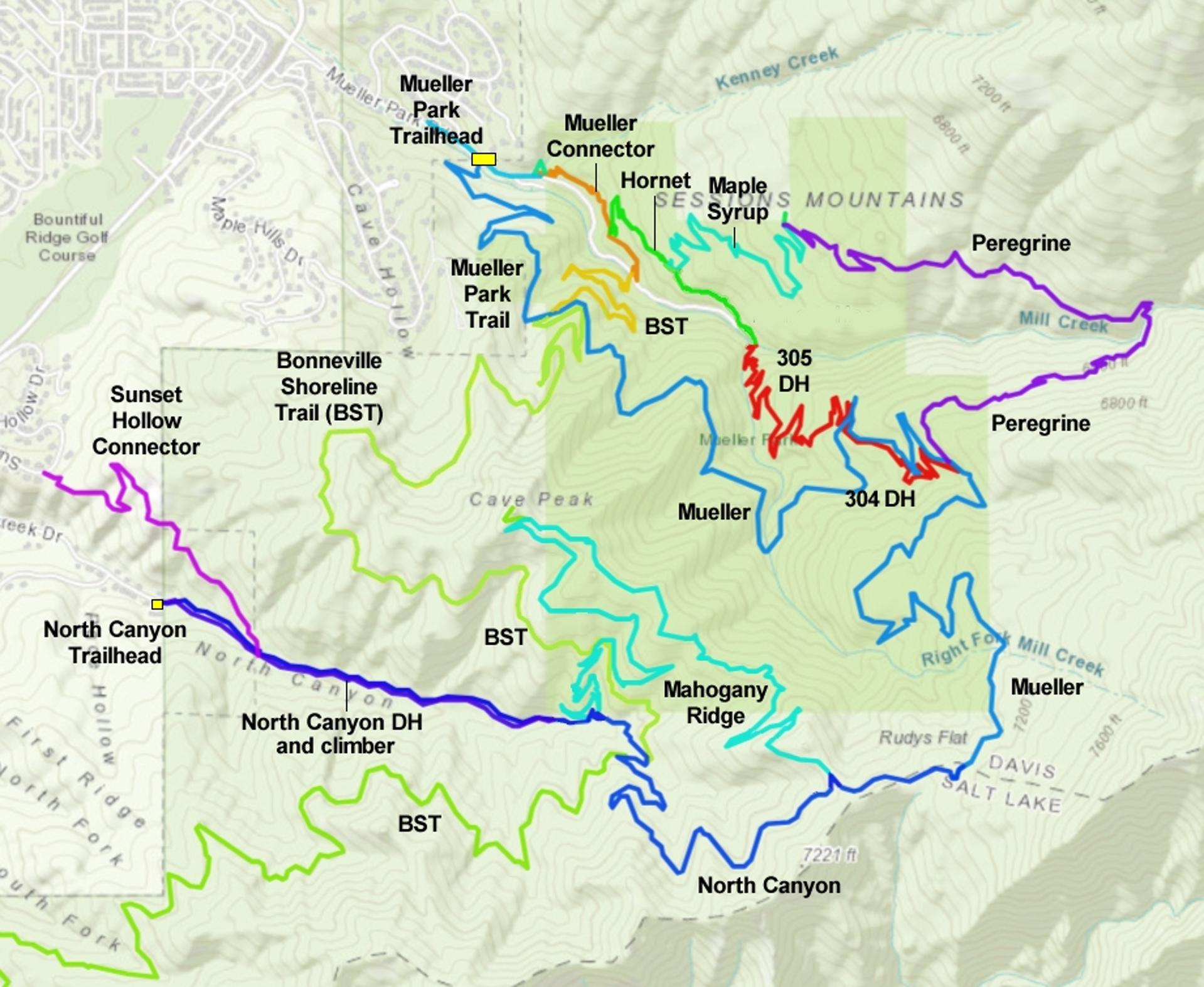
The Mahogany Ridge trail is an easier scenic alternative to the North Canyon trail above Bountiful. This 4.2 mile trail is open in summer 2025. The trail is two-way non-motorized trail with a smooth surface and gentle slopes, suitable for less-strong riders. Mahogany Ridge lies on National Forest land. This trail will be a game-changer for the North Canyon area.

Mahogany Ridge can substitute for the North Canyon trail in any loop ride of Mueller Park. But it's over twice as long! So why would you do that? Well, it's a very very good ride. Mahogany Ridge was constructed using modern trail-building techniques and sustainable alignment. So it's a pleasant trip uphill or down. Nice views, nice riding. I'm giving this new trail 5 stars!

Bruce cruises a typical section of Mahogany Ridge.
Looking east as we arrive on the ridgeline. The trail       fork for the Cave Peak spur is straight ahead.
Looking east as we arrive on the ridgeline. The trail fork for the Cave Peak spur is straight ahead.
For climbing, Mahogany Ridge is less of a grunt than North Canyon. Instead of putting 750 feet of elevation gain into 1.9 miles on the North Canyon trail, you'll spread it out over 4.2 miles.

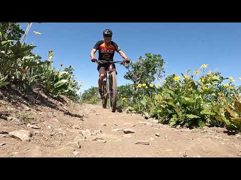
Mahogany Ridge is also, in my opinion, far superior in views and fun factor. When cruising downhill, you can take in the views and swoop the turns of Mahogany Ridge, instead of hanging your butt back with brakes constantly engaged on the fairly straight drop down the old North Canyon trail.

The trail is a highly-engineered machined bench-cut. Turns are highly banked and ride nicely uphill or downhill. There are a couple of features that you can use as a table jump or a launching rock, but the surface is easily rolled by anyone who can pedal a bike. The rate of climb is always gentle, and there are no spooky exposures or steeps.

The terrain is mostly maple and oak, with an occasional stand of fir or aspen. At the right time of year the wildflowers are impressive.

Rolling a banked turn in a riot of mules ear flowers.
Looking north from Cave Peak.

Mahogany Ridge forks away form the North Canyon trail just 1/10th mile above the National Forest border (a mile uphill from pavement) at 6230 feet elevation. It crosses the Bonneville Shoreline trail 0.9 miles later after gaining a bit over 200 feet elevation.

Mahogany Ridge is also a popular route to the Cave Peak overlook viewpoint. This comes at mile 2.2, just after the trail reaches the ridgeline.

On the ridgeline, the Mahogany Ridge trail will drop through a couple of saddles. So your total climbing when using Mahogany Ridge as your uphill route will exceed the elevation change by around 250 vertical feet. The top of Mahogany Ridge rejoins North Canyon at 4.2 miles. The elevation here is 6950. To reach Rudy's Flat, you'll need to get up 1/10th mile of fairly steep, loose, and eroded North Canyon trail before the trail flattens out and you can cruise to the top of Mueller Park at Rudy's Flat (7150 feet elevation).
Cruising south on upper Mahogany Ridge.
We're on an S-turn on lower Mahogany Ridge in a grove       of aspen and fern.
We're on an S-turn on lower Mahogany Ridge in a grove of aspen and fern.
The loop of lower Mueller, the BST, upper Mahogany Ridge, then a descent down Mueller (plus or minus Peregrine/Hornet or the 304-305 DH route) is a great option. (Note: the track on this page has an exploratory drop down lower Mahogany Ridge from the BST -- and back up -- adding two miles and 200 feet of climbing.) For the classic Mueller descent, it's 15 miles with 2200 feet of overall climbing. The Peregrine route will be a bit longer, while the DH option will be a little shorter.
Trailheads and Connections
End of Canyon Creek Road. The singletrack begins on       your right 100 feet uphill.
End of Canyon Creek Road. The singletrack begins on your right 100 feet uphill.
North Canyon Trailhead

At the uphill end of Canyon Creek Road in Bountiful (reached via Bountiful Blvd), you can find roadside parking and begin pedaling uphill. You'll have the option of gravel service road or a singletrack trail on the right (south) side of the road, found 100 feet uphill from the gate. The first mile will be relatively steep (around 500 vertical feet of climbing). The pitch mellows once you reach the National Forest border. A bit after the forest border (1/10th mile), the trail splits. The trail straight ahead, signed 601, is North Canyon. The unmarked (as of June 2025) trail on the left is Mahogany Ridge.

NOTE: There's a plan for a road and formal trailhead for access to North Canyon. As of my last visit to this trailhead, these instructions are accurate.

The small parking strip at the Mueller Park trail.       The road on the left goes through the park to the Bonneville Shoreline       Trail.
The small parking strip at the Mueller Park trail. The road on the left goes through the park to the Bonneville Shoreline Trail.
Mueller Park over Rudy's Flat

The Mueller Park trailhead is reached the Mueller Park road, which is a continuation of 1800 South Street in Bountiful. This is a popular trailhead and will be crowded on weekends. The Mueller Park trail climbs to the top of Rudy's Flat in 6.3 miles. On the way, you'll cross the Bonneville Shoreline Trail and pass the connections to Peregrine and the 304 DH. Keep straight at the summit and the trail will deliver you to the top of the North Canyon trail. Drop down 0.5 miles. As North Canyon makes a turn to the left, the top of Mahogany Ridge is on your right.

Arriving on the BST from Mueller Park. The uphill       (left) trail is Mahogany Ridge.
Arriving on the BST from Mueller Park. The uphill (left) trail is Mahogany Ridge.
via the Bonneville Shoreline from Mueller Park

At mile 1.3 of the Mueller Park trail, turn hard to the right on the BST. It will be 3.5 more miles (and 750 vertical feet of climbing with a short bit of descent) to the spot where Mahogany Ridge crosses the BST. Veer left to climb Mahogany Ridge or make a hard right to descend. (You can also continue downhill on BST, drop down a bit of North Canyon, the make a hard right turn where the bottom of Mahogany Ridge forks away from the North Canyon trail.)

Bruce rocks the BST on the way to Mahogany Ridge.
from the Wild Rose area via the BST

For now you'll need to climb uphill from the Wild Rose trailhead in Woods Cross. (See the Wild Rose trail page.) Take the Wild Rose Overlook trail up the ravine, then hard right at the 5-way trail intersection and up to the ridgeline. At mile 0.8 the BST crosses. Turn left. (The southbound BST to the right dead-ends at this time.) It will now be 8 miles to the North Canyon trail, where you'll keep straight and descend 0.2 miles. Here you can either make a hard right turn onto the BST to catch Mahogany Ridge where it crosses the BST, or drop down North Canyon 0.3 miles to the bottom of Mahogany Ridge and turn hard right.

Notes on the Mahogany Ridge trail
We've arrived. Mahogany Ridge is the trail on the       left.
We've arrived. Mahogany Ridge is the trail on the left.
From the North Canyon trailhead, take either the singletrack or the doubletrack uphill. You'll pedal one mile, gaining 500 vertical feet. At the National Forest border -- marked by a sign -- keep straight uphill. In 0.1 miles, the trail will split. In June 2025, the bottom of Mahogany Ridge had no signage, although trail-posts were present at the BST ctross-over.

The trail to the right is North Canyon. Turn to the left onto Mahogany Ridge.

Mahogany Ridge is a machined bench-cut. The rate of climb is gentle but steady. Turns are banked for downhill grip but easy to ride uphill.

You'll gain 200 vertical feet of elevation over 0.9 miles as the trail winds back and forth across the south-facing hillside. Then you'll arrive at the BST trail fork.

A banked turn on lower Mahogany Ridge.
Approaching the BST cross-over while climbing       Mahogany Ridge.
Approaching the BST cross-over while climbing Mahogany Ridge.
At the Bonneville Shoreline Trail (BST) cross-over, the intersection is well-marked. Just go straight across the BST and continue climbing.

If your ride plan includes the BST, turning left (north) will take you to the lower Mueller Park trail, 1.3 miles above the trailhead. You'll be able to cross over Mueller Park to stay on the BST.

A right turn here will descend the BST to the North Canyon trail. Here you'll need to fork left uphill for 0.2 miles on North Canyon to reach the continuing Bonneville Shoreline southbound toward Wild Rose.

For the next mile or so, the trail is a broad bench-cut running back and forth across the side-slope. Catch a view mountain views and enjoy the riding. It gets much more interesting higher up.
Typical trail view as we slowly gain elevation.
Breaking out of the maple and oak forest as we       approach Cave Peak.
Breaking out of the maple and oak forest as we approach Cave Peak.
Maple and tall oak will give way to shorter scrub oak as you approach the ridgeline. The trail will change from a generally northwest direction to eastbound as you arrive on Mahogany Ridge east of Cave Peak.
At mile 2.2 from the bottom of the trail on North Canyon (1.3 miles from the BST cross-over), you'll arrive at a marked trail fork. Here the main trail seems to turn 180 degrees left. This is the Cave Peak spur. Go ahead and take it as a short out-and-back, then return to this trail fork to take the narrower Mahogany Ridge trail southeast.
At the trail fork for Cave Peak, the main trail makes       a banked turn to the left. But the smaller trail on the right -- shown       here -- is Mahogany Ridge.
At the trail fork for Cave Peak, the main trail makes a banked turn to the left. But the smaller trail on the right -- shown here -- is Mahogany Ridge.
View to the north from the lower viewpoint.
The Cave Peak spur has two viewpoints. At the first view, 100 yards from the trail fork, the trail turns right and climbs steeply to the peak's summit. It's loose and narrow. So while many riders fight their way uphill for this 100-foot climb, I'd suggest you just leave your bike and hike up.
On the ridge, the trail meanders through wildflowers and groves of oak. There's an occasional stand of mature maple and fir.

The Mahogany Ridge trail now works its way southeast, staying near the ridgeline. You'll occasionally drop through a shallow saddle. When approaching the sharper peaks, the trail will hug the side-slope as you pedal toward the next saddle on the ridgeline.

Easy cruising as wildflower meadows alternate with       groves of oak.
Easy cruising as wildflower meadows alternate with groves of oak.
We're at the fork with North Canyon!
At mile 4.2 from its origin on the North Canyon trail, the Mahogany Ridge trail will rejoin North Canyon. It your ride plan was to simply climb Mahogany Ridge and return back to town or to the BST, keep straight and right to descend North Canyon.
To connect through Rudy's Flat to Mueller Park -- which you must do if you plan to descend via the 304-305 DH or Peregrine -- turn left uphill. The North Canyon trail here is moderately steep, eroded, and covered in loose rock. If you have enough leg left, it's ride-able. But it will immediately remind you how nice the Mahogany Ridge trail was.
Pedaling through the mules ear blooms.
Another rider's view of the ridgeline trail.

In 0.4 miles, the North Canyon trail become the Mueller Park trail and begins descending. It will be 2.2 miles down to your first alternate descent, as Peregrine forks to the right and the DH makes a hard 180 to your left. To descend Mueller, keep straight.

Loop of Mahogany Ridge

[Back to video list ]
Bottom Line!

Excellent ride. Lots of nice views and wildflowers. Easy technically and aerobically, although the distances and elevation change of the loop-ride options might be difficult for less-strong riders.

Bruce pedals into a ridgeline saddle.
Getting there:

Mueller Park: On I-15, take the 2600 south Bountiful/Woods Cross exit. Go east towards the mountains. The road will turn north and be renamed Orchard Drive. While heading north, turn right (east) on 1800 south. This street takes you to the trailhead about 2 miles later, where you'll see parking places on the right side of the road. Go across the stream on the bridge to begin the ride.

North Canyon: On I-15, take the 2600 south Bountiful/Woods Cross exit. Go east towards the mountains. The road will turn north and be renamed Orchard Drive. While heading north, turn right (east) on 1800 south. Just as you reach the bottom of a steep hill, turn right at the intersection. (This is about 0.6 miles before the Mueller Park trailhead. If you arrive there, backtrack.) After 1.7 miles, turn left on Canyon Creek and go uphill 0.7 miles to the end of the pavement. Start your ride by heading east (uphill) on the dirt road.