Looking east at the Clark Ranch area from Lynx.
Lynx Trailwith Foxtail trailThe Lynx trail ties a spur of the Rail Trail to the top of the Foxtail
trail. It lies across Kearns Blvd from Round
Valley, just off Landfill
Road. Lynx is a two-way trail, 1.6 miles in length, with 450 vertical feet
of climbing. It was completed in late 2022, forming a companion trail to
the nearby Skid Row. On this page the trails I describe create a loop ride
of 3.5 miles.
The trail is a benchcut with a gentle rate of climbing or descending. It's a more-gentle slope than Skid Row, so most riders will want to do a clockwise loop of these two trails, taking the Pipeline singletrack from the bottom of Skid Row to Lynx for the climb, then connecting via a short bit of Foxtail to the top of Skid Row for the descent.

Looking down at one of the climbing turns as the Lynx trail winds around to gain elevation at a gentle pace.

Approaching Park City Heights on the Pipeline connector. Lynx forks uphill to the right just as you're approaching the homes.
There's no specific trailhead for Lynx, so you'll need to
arrive from somewhere else. The most direct access is through the upper
Foxtail trail at the end of Fox Tail Trail street (see below). You can
connect from
Lost Prospector through Skid Row and either Foxtail or the
Pipeline connector (see details below). Or you can catch the trail at the
bottom by climbing a short spur from the paved Rail Trail. My suggestion
is that you park at Round Valley and take the paved connector under Kearns
Blvd, then turn toward Park City on the Rail Trail and fork uphill on the
spur after crossing Landfill Road.
Trailhead and Connections

On the paved spur from the Rail Trail. The Lynx trail is straight ahead.
Via the Heights spur from the Rail Trail (bottom of Lynx)As the Rail Trail crosses Landfill Road, there's a spur heading uphill
toward the homes. Very quickly, it will split. Fork to the right, then
follow the paved trail up along the row of townhomes. As the paved trail
turns left, continue straight onto singletrack and immediately fork left
uphill on Lynx. (The lower trail on the right is the Pipeline connector
trail.)
Via Foxtail Trail (top of Lynx)
At the end of Fox Tail Trail road, find the singletrack. Keep straight as
a connector forks left. After 100 yards, keep right as Foxtail veers to
the left and you're descending Lynx.

Eastbound on Lost Prospector.
Via Lost Prospector
As you hit the eastern end of Lost Prospector, turn to the right uphill on
Skid Row. Climb 0.4 miles and fork left on Foxtail. (The trail straight
ahead is not official. It goes over to the origin of Foxtail.) After 0.2
miles, fork to the left onto Lynx. Note that in August 2023, this trail
intersection is not marked.

Starting uphill in a meadow as we leave the paved spur from the Rail Trail.
The Lynx trail is 1.6 miles long, with 450 feet of elevation change. The bottom of the trail is in the Park City Heights subdivision, at a paved spur from the Rail Trail. (I recommend against parking at the clubhouse in the subdivision. Please pick a formal trailhead to start your ride.)
At the spot where the Rail Trail crosses Landfill Road (and
sends a spur under Kearns Blvd to Round Valley), a spur climbs south. Keep
to the right as it splits and pedal up along the townhomes. As the paved
trail turns 90 degrees left, keep straight onto dirt singletrack, and fork
to the left uphill.
The trails are not marked at this time (August 2023). The lower trail
on the right is the Pipeline trail, connecting to Skid Row. The upper
trail bearing left is Lynx.

Wildflowers thrive among the sage as we climb toward the forest.

Most of the trail is shaded by oak and maple forest.
The trail climbs from sage meadows into an oak and maple forest. There will be a series of climbing turns around mile 0.5, and you'll cross a gravel road at mile 0.8.
While most of the ride is in forest, you'll have an occasional breakout view of the Clark Ranch area to the east, and the Round Valley riding area to the north.

At a break in the trees, we're looking north toward Round Valley.

Almost there, as an occasional fir and aspen appear among the maples and oak.
When the trail forks at mile 1.6, that's the end of Lynx. To the left, Foxtail goes 100 yards to a turnabout at the end of Fox Tail Trail (a road). To the right, Foxtail will climb and circle a small hill to descend to a trail fork with Skid Row before continuing around to a subdivision street.

Looking west on Foxtail at the spot where Skid Row forks away.
The Foxtail trail starts at the end of the Fox Tail Trail paved street and ends on Fox Glen Circle. (Across the street is a connector that can take you to the Gambel Oak trail.) It's 0.8 miles long, with around 100 vertical feet of climbing. For the loop ride, you'll only be on Foxtail for 0.2 miles.
Foxtail is one of the older trails in Park City. There's some up-and-down riding with steeper pitches than some riders are used to, and the track is narrow. While the start and finish are at the same elevation, there's significant climbing and descending over the 0.8 miles between Fox Tail Trail and Fox Glen Circle.

A view north toward Round Valley as Foxtail crosses a low hill.

View to the east on Foxtail.
The scrub oak is smaller on Foxtail, so take advantage of
the views before you drop onto Skid Row.
Riders who are making a loop of Skid Row and Lynx will ride
only a short portion of Foxtail. If you're climbing Lynx, turn right at
the 1.6-mile trail fork and follow Foxtail around the hill for 0.2 miles.
Turn right downhill as a trail crosses, and you're on Skid Row.
You can also connect (with less climbing and a slightly shorter distance) by forking left on Foxtail. Just before it hits the road, turn right and climb across the low ridge. This is the Skid Row connector. After just under 0.1 miles, cross over Foxtail to descend Skid Row.

We're approaching Fox Glen Circle after climbing over a hill. This is not part of the loop I'm describing, but explore the rest of Foxtail if you like!

Plunging into the maples on upper Skid Row.
Skid Row is a two-way trail, 1.2 miles in length, with 450 feet of elevation change. Because it's a steeper trail than Lynx, I'm suggesting you ride it as the downhill portion of your loop.
Skid Row officially starts on Foxtail, 0.2 miles from the top of Lynx. But it's actually the continuation of a 0.1-mile connector from the top of Foxtail (which took the "long way" around the small hill).

I'm standing on the end of the Lost Prospector trail. Both trails here are Skid Row -- uphill (right) or downhill (left).

Looking west along Kearns Blvd toward Park City.
If you arrived at Skid Row via Lost Prospector, you can head left uphill on Skid Row 0.4 miles for a counterclockwise ride (descending Lynx after connecting via Foxtail) or go left downhill to do the bottom 0.8 miles of Skid Row before taking the connector over to Lynx.
At the final turn of Skid Row, around 100 feet from the bottom, the alternate (uphill) connector continues straight while Skid Row turns hard left. And just 30 feet from the Rail Trail, the Pipeline connector trail crosses Skid Row.

Lots of twists and turns on Skid Row!

View in the uphill direction as the trail climbs through a small aspen grove.
If you decided to do the loop counterclockwise -- climbing Skid Row then descending Lynx -- be aware that the pitch is sustained at an average of 9% and riders will be coming around blind turns at high speeds. So if you're going to climb Skid Row, I suggest a weekday ride.
Connector singletrack ("Pipeline" and the Skid Row Pipeline Alternate)

Westbound on the connector, this is the trail fork between the upper (newer and more lush) trail and the trail along the pipeline route on the right. Both trails run parallel to the Rail Trail, and both get you where you want to go.
The bottom of Skid Row and the bottom of Lynx are tied together by a traversing dirt trail that runs parallel to and just uphill from the Rail Trail. This connector is 0.5 miles long.
For the western 2/3 of the connection, there's a second (more lush) new singletrack alternative slightly higher on the hill. As of August 2023, neither of the trails are marked with signs.

On the higher singletrack, looking west.

View to the east on the connector trail.
On the western end, the Pipeline alternate crosses Skid Row just 30 feet from the Rail Trail. (Westbound, it continues another 0.6 miles parallel to the Rail Trail before joining it.)
The second singletrack forks away from Skid Row just uphill, at the lowest switchback. It joins the less-exciting Pipeline route after 0.3 miles.

The connector trail totals 1.1 miles. It's split into two nearly-equal sections where it crosses Skid Row.

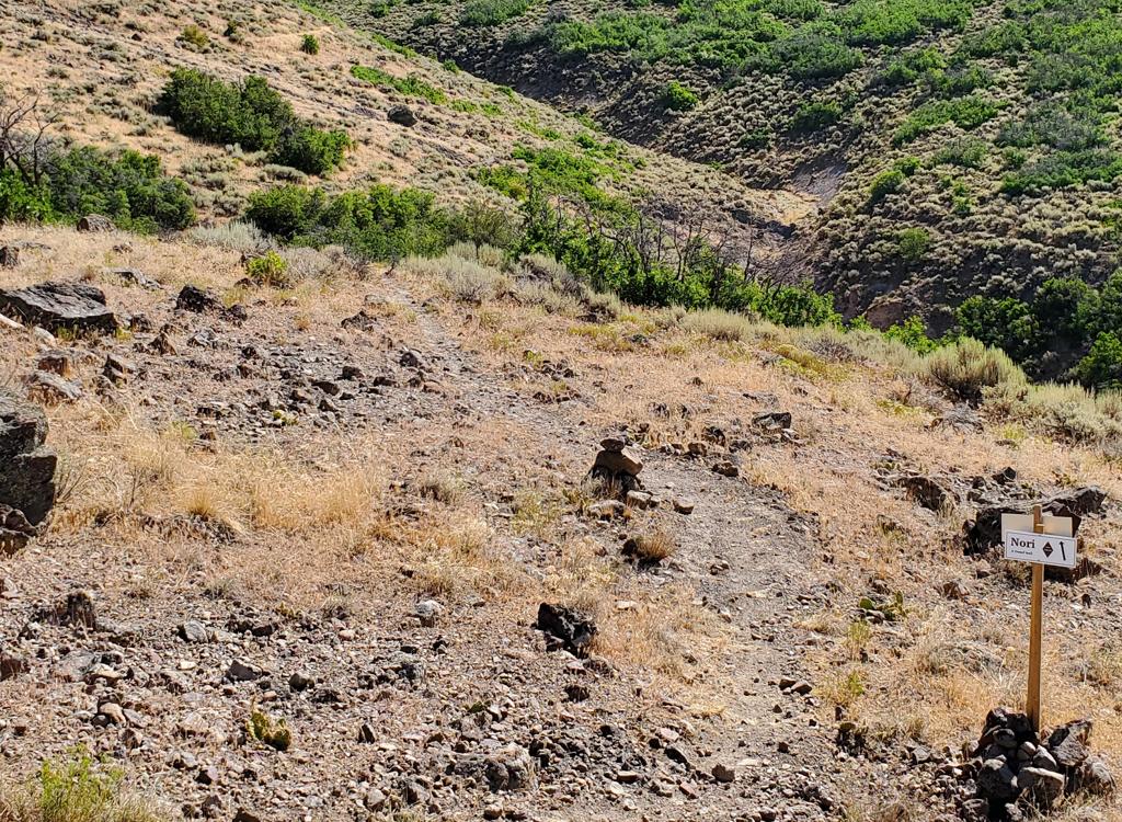
Closeup of the Lynx Trail area.
Round Valley Quinn's trailhead: On I-80, turn south at Silver Creek Junction (towards Heber). At the second exit
(about 3 miles later) turn right towards Park City on Kearns Blvd (Highway 248).
Less than 1/4 mile from the exit, turn right at the light onto Round
Valley Drive. Quickly turn left onto Gilmor Way. Turn left into the first
parking lot. Find the paved trail on the eastern end and go left, west,
until it passes under Kearns Blvd. At the fork, turn right to cross
Landfill Road, then turn left uphill on the spur. Fork right as the trail
splits and find the singletrack at the end of the homes.
Lost Prospector: There's room for a couple of cars at the
southwest corner of Lost Prospector just uphill from Deer Valley Drive on
Aerie Drive. Pedal 3.2 miles to Skid Row, then navigate as described above
to Lynx.