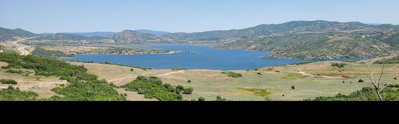
Looking north at the eastern bay of Jordanelle from the Beep Beep trail.
Jordanelle Ridge North
Beep Beep, Road Runner, Puddy Tat, Tweety BirdThis page discusses four trails newly opened in 2025 on the far northern end of the
Jordanelle Ridge (Coyote) trail system. The entire area is undergoing rapid
evolution with construction of subdivisions and a golf course. So some of
the information here may become outdated quickly. Note also that trailhead
access has changed! This page is the status as of June 24, 2025.
Three of the new trails fork off the route called Beep Beep.
These are Road Runner, Puddy Tat, and Tweety Bird. (Road Runner also
connects to northwestern Riverview (Coyote) and An Unexpected Journey where western
Riverview crosses the ridgeline at the northwestern corner of the riding area.)
Beep Beep spans from the Coyote Riverview Connector trail -- just below
its connection to Coyote -- and the western side of northern Riverview,
formerly known as part of the Coyote Loop.
Most riders on these trails will start from the parking spot at the
bottom of the Wile E Canyon loop. But they
can function as alternate routes for any ride involving Coyote.

Bruce cruises westbound along Beep Beep.

Looking down at the tight turns on Puddy Tat.
These new trails are fairly easy riding. Tweety Bird and
Road Runner are rated easy, and can be done by beginning riders. Beep Beep
and Puddy Tat have some steeper sections -- although still pretty plush --
and tighter turns. These two trails also have some occasional embedded
boulders that warrant an intermediate rating.
The trails are two-way. Turns are banked to help you hold
your riding line. Some of these turns ride best in a specific direction
though. For example Puddy Tat feels best when done downhill. And there are
a couple of engineered turns on Beep Beep that are hard for an
intermediate rider to power up and around when doing the trail from west
to east.

Turns are nicely banked for riding uphill or down.

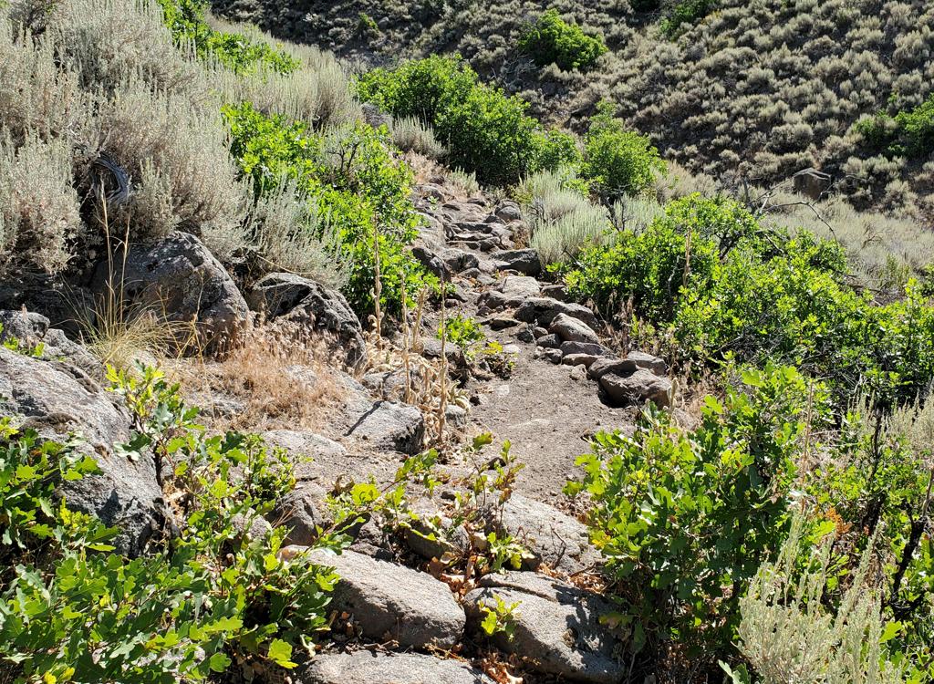
A typical sample spot where granitic boulders break through. Usually very easy to simply bounce over.
Except for a few short stretches, all four of these trails
are broad machine-built bench-cuts. There are a few outcrops of granite
that poke through the trail surface in spots. Some of these are rough
enough to make newer riders dismount. But overall, 99% of the trail
distance is smooth dirt.
If you haven't been to Coyote recently, here's the trailhead
situation as of June 2025. (1) The northern Riverview parking (for the
Riverview Connector) has a new road under construction. If you're riding
from the eastern side, you'll need to take the longer route from UVU
parking. (2) The Cutthroat trailhead on Highway 32 has also been mauled by
road construction. The connector trail is still there, but no safe parking
spots. (3) There's a new Wile E Canyon trailhead located just below the
eastern side of the Wile E Canyon loop, which should be your access for
now. If it's full -- and it's pretty small -- I suggest you park with the
construction workers' vehicles on the north side of the highway (you'll
see it) and pedal to the trail. (4) There will be parking at the bottom of
Puddy Tat and Tweety Bird, but right now it's just a mini-ex sitting in a
tiny area of scratched-aside sage brush on an unmarked doubletrack off
Highway 32. See below for full trailhead info.

Bruce heads east around a banked turn on Beep Beep.

Climbing through gambel oak on Beep Beep.
Future subdivision construction is planned for the big
meadow that lies north of Tweety Bird and west of Puddy Tat. It's said
that the construction
will close the Tweety Bird trail, but I don't know if it will be temporary
-- like what happened with Looney Tunes -- or if the trail will be
permanently lost like upper Chop'd Coyote. Enjoy while you can.
Note also that trail names have changed -- and continue to change --
for what used to be simply the Coyote Loop. So when an experienced
Jordanelle Ridge rider is describing a route to you, he or she may use any
of three or four names for certain sections of older trail. For example
the Cutthroat Switchbacks could be called Coyote or Northern Riverview or
East Riverview. When in doubt, pull out your Trailforks App. I'm not
guaranteeing the "official-ness" of any trail names I use on
this page!

View toward Jordanelle from Road Runner.
Nearest Trailheads (see page bottom for full list)

Looking south in the Wile E Canyon trailhead.
Wile E Canyon trailheadThe Wile E Canyon trailhead is located on the southern side of Highway
32, just over 4 miles from US-40. It's 1/10th mile east of the old
Cutthroat trailhead (see below). There's room for about 8 cars here. From
the parking lot, a connector trail takes you 120 yards uphill to the Wile
E Canyon loop. To get to Beep Beep (or the Coyote Switchbacks or East
Riverview), turn right at the trail fork, keep right at the next fork,
then turn left onto the Coyote Riverview Connector trail as you approach
the gravel road.

The trail in the center of this photo is the old access from parking. The step-over is falling apart, so don't use it!
Coyote Riverview Connector trail (old Cutthroat)You can still connect through the old Cutthroat trailhead, although
there's no longer a parking area here. For example, if the crowds have
forced you to park where construction workers leave their vehicles along
Highway 32, you can pedal to where the gravel road to the new golf course leaves
the highway and find the singletrack. It's four miles east of US-40 and just east of the big rock-wall
road-cut.

Looking south from the shoulder of Highway 32 at the Puddy Tat parking spot.
Puddy Tat parkingOn Highway 32 around three miles from US-40, watch for a dirt road
turning to the right in a huge sage meadow. There are a couple of
buildings across Highway 32 at this spot. The parking spot is just through
the fence, with a connection to Puddy Tat on the eastern side of parking.
(This spot was still being worked on at the time of my review.)

An unimpressive beginning of Beep Beep on the Coyote Riverview Connector. Find your way across the road and it gets way better!
Beep Beep is 1.8 miles long. It provides access to the top
of Puddy Tat, Tweety Bird, and the eastern end of Road Runner. The Beep
Beep trail runs in an east-west direction, roughly parallel to the
northern side of Coyote (northern Riverview) but lower on the hillside.
On the eastern end, Beep Beep forks away from the Coyote
Riverview Connector trail about mid-way between the Wile E Canyon loop and
the Coyote trail (also called Cutthroat Switchbacks plus both northern
Riverview and eastern Riverview). This trail
fork is just west of the trail fork for the connector
trail down to (what used to be) the old Cutthroat trailhead. Beep Beep quickly crosses the
gravel road and climbs a sage-covered ridge heading northwest.

Heading into the first set of banked turns as we ride west on Beep Beep.

Bruce rolls a turn on Beep Beep.
On the western side, Beep Beep branches off the Riverview
(Coyote) trail just east of the ridgeline where western Riverview turns
from northbound to eastbound.
When riding uphill on Beep Beep, it's just 1/10th mile further from the top of
Road Runner to join Riverview, then another 1/10th mile west to the ridgeline.
At the bulldozed platform on top of the ridge, you'll find An Unexpected
Journey on your left, Riverview straight ahead, and Road Runner to your
right.
The overall elevation change for Beep Beep is less than
you'd expect. The western end is a bit over 50 feet higher than the
eastern side. But over the course of the trail you'll descend then climb back out. So your total
climbing on Beep Beep will be around 200 vertical feet.

A tight set of turns in mature forest.

Looking toward Jordanelle from western Beep Beep.
As the oldest of the four new trails, Beep Beep has had a
little time to settle. So the surface is fairly solid, if a bit bumpy. The
berms on tight turns can still be a bit loose, so don't get too aggressive.
When riding from east to west, you'll hit the top of Puddy
Tat at mile 0.8 from the origin of Beep Beep at the Coyote Riverview
Connector trail. Puddy Tat drops to your right downhill. The combination
of Puddy Tat downhill and Tweety Bird uphill (plus a bit of Road Runner
and Beep Beep) makes a nice loop.

A cool grove of tall maples.

Beep Beep reaches Riverview. We're standing on Riverview looking east, with Beep Beep dropping downhill on the left.
Your next trail fork will be Road Runner, on your right heading
downhill at mile 1.7. Road Runner descends to the top of Tweety Bird, then
climbs up and around to the ridgeline trail fork between An Unexpected
Journey and Western Riverview (Coyote).
Beep Beep is an intermediate trail overall. There are a few
spots where granite boulders poke through the trail surface. It's usually
pretty easy to bang through or dodge the rocks, but there's one short rock
garden that will challenge even intermediate riders.

Looking east as Beep Beep crosses another sage meadow.

Cruising on a smooth section!
The terrain alternates between sage meadows -- where you'll
often find a few bumpy igneous rocks -- and tall oak. There will be some
cooler north-facing slopes where there are stands of mature maple and a
rare quaking aspen.
You'll have frequent views of Jordanelle to the north.

Just below Beep Beep, we're looking into the first banked turn of Puddy Tat.
The Puddy Tat trail forks downhill from Beep Beep at mile
0.8 from the Coyote Riverview Connector. This is mile 1.2 from the Wile E
Canyon trailhead.
Puddy Tat is a two-way trail, but most riders will prefer it
as a downhill. The trail extends 0.6 miles down from Beep Beep to a small
parking spot along Highway 32. (Tweety Bird turns uphill from Puddy Tat
just 100 feet from that parking spot.)

Looking uphill on lower Puddy Tat.

Approaching a dip through a shallow ravine.
In the downhill direction, Puddy Tat starts with a series of
tight turns in a sage meadow. It will drop through a drainage and climb
the other side, then meander through sage and short oak scrub to the
trailhead.
Puddy Tat would be rated an intermediate trail, but on the easier side
of intermediate.
You'll probably want to combine Puddy Tat as a downhill with
Tweety Bird as a climb, then use western Road Runner and western Beep Beep
to complete a loop.

Seen from downhill, this broad banked turn screams "do it the other direction!"

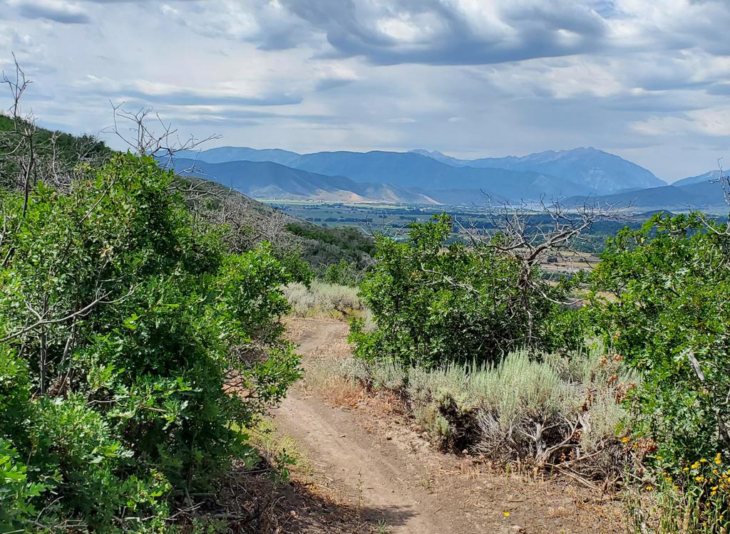
Looking east from the western end of Road Runner near the Riverview ridge crossing.
Road Runner is an easier trail that's exactly one mile long.
There's 100 vertical feet of climbing over the course of the trail, in
either direction. The top elevation of Road Runner is around 6800 feet.
The Road Runner trail starts on the ridgeline where
Riverview crosses over a saddle. (If you're coming from the west, it's the
spot where the northbound trail stops climbing and turns to head eastbound
downhill.) It's opposite the northern end An Unexpected Journey.

Western side of Road Runner joining onto Beep Beep, looking east.

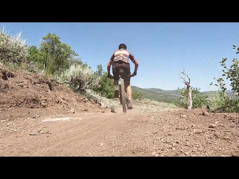
Heading north on a clockwise ride.
Road Runner initially heads north through a sage hillside.
As it reaches the forested northern side of the hill, it turns to head back south.
After descending 1/2 mile, it runs flat for 1/4 mile. At the Tweety Bird
trail fork, you'll go to the right uphill and climb through a series of
turns 1/4 mile to connect into Beep Beep.
Road Runner's eastern end is on upper Beep Beep, just 1/10th
mile down from the Riverview trail and 0.2 miles from Road Runner's
western origin on the ridgeline. Road Runner is exactly one mile in
length. While the beginning and end are at around the same elevation,
you'll descend -- and climb back -- 100 vertical feet.

A rare alternate line with this rock roll-over.

At the lowest elevation, you'll hit a bit of maple forest.
Road Runner is an easy trail overall. Beginners can climb
uphill through Tweety Bird to ride a loop of Road Runner at the top. Any
other way of getting to Road Runner needs at least intermediate skill and
fitness (assuming there isn't going to be a public road to the
ridgeline in the future).
Road Runner's newborn status is obvious in summer 2025.
Expect the banks on the turns to be soft. Take it easy and don't destroy
the berm-work! There will be some bits of root. Only a few of them are
long enough to catch in a derailleur, but...

Climbing around a turn in the fresh trail.

Looking east on upper Tweety Bird.
Tweety Bird is an easy trail. It's 0.6 miles long with just
under 200 vertical feet of climbing. At the bottom, Tweety Bird forks to
the right from Puddy Tat just outside the western trailhead on Highway 32.
At the top, Tweety Bird ends on Road Runner at Road Runner's lowest elevation. (From
this trail fork, you can climb either direction on Road Runner, which is
also an easier-tech trail. Going to the right, for a counterclockwise
loop, is probably easiest.)
The trail surface is smooth dirt. One table jump has been
created near the end of the trail, but it's easy to simply ride around.
Otherwise there are no tech features. Tweety Bird is suitable for
beginning riders.

A look north toward Jordanelle.

Lower origin of Tweety Bird on Puddy Tat.
Tweety Bird is a mix of sage meadows and oak groves. There
will be frequent views of the Jordanelle Reservoir to the north.
The word from the local trail org is that Tweety Bird will
be affected by subdivision construction in the future, and will be closed.
It may be re-routed, temporarily closed, or lost forever. Who knows. But enjoy your
permission to ride on this private property for now and don't whine about
the future!

Winding through oak groves on Tweety Bird.

View of Jordanelle from western Road Runner.
Bottom Line!Fun and scenic miles that add to the riding options of the Jordanelle
Ridge area. These trails will be of interest to riders that don't have the
stamina or leg power for longer rides and stiffer climbing. Easy riding,
but with an occasional push-a-bike for beginners on steeper turns and
bumpy rock gardens.
Getting there!
Wile E Canyon trailhead: The Wile E Canyon trailhead is located on the
southern side of Highway 32, just over 4 miles from US-40. It's 1/10th mile east
of the old Cutthroat trailhead (see below). There's room for about 8 cars here.
From the parking lot, a connector trail takes you 120 yards uphill to the Wile E
Canyon loop. To get to Beep Beep (or the Coyote Switchbacks or East Riverview),
turn right at the trail fork, keep right at the next fork, then turn left onto
the Coyote Riverview Connector trail as you approach the gravel road.
Coyote Riverview Connector trail (old Cutthroat): You can still
connect through the old Cutthroat trailhead, although there's no longer a
parking area here. For example, if the crowds have forced you to park where
construction workers leave their vehicles along Highway 32, you can pedal to the
gravel road to the new golf course leaves the highway, four miles east of US-40
and just east of the big rock-wall road-cut.
Puddy Tat parking: On Highway 3 around three miles from US-40, watch
for a dirt road turning to the right in a huge sage meadow. There are a couple
of buildings across Highway 32 at this spot. The parking spot is just through
the fence, with a connection to Puddy Tat on the eastern side of parking. (This
spot was still being worked on at the time of my review.)
Riverview trailhead: From US-40 just south of the Jordanelle reservoir,
turn east at the traffic light onto Highwat 32 (at mile 14.2 from I-80 if you're
coming from the north). On Highway 32, climb 1.1 miles. When you see the second
entry into Riverview on your left and a road under construction to your right,
the Riverview Connector trail starts on the uphill side of that road just after
it leaves Highway 32. (In 2025, there's no longer protected parking here. It's
unclear whether the trailhead will be restored when construction is complete.)
UVU Wasatch Campus Trailhead: One mile south of the junction of
Highway 40 and 32 (a couple of miles north of Heber), turn east (toward the
mountain) at the UVU campus. Go to the uppermost level of parking behind the UVU
buildings. Look for the duck-under and kiosk A singletrack trail climbs 1.5
miles to the Riverview Trail.
Coyote Trailhead: The southern Coyote trailhead has been lost to
subdivision construction. Access to the southern side the trail system is in
limbo, but some riders find their way through the construction zone by pedaling
up the gravel Coyote Canyon road.
Canal DT trailhead: Just uphill from the light on highway 32, watch
for the canal crossing. Park along the road. Start riding south on the
doubletrack just uphill from the canal.