
Skills park, Lower Potatoes, Upper Potatoes
This page reviews the easier trails at the northwestern side of the Coyote Canyon/Riverview trail system just north of Heber. This includes the Isengard skills area and flow trail, plus Upper Potatoes and Lower Potatoes DH. There are small trailside signs identifying the trails at forks and cross-overs, but a GPS navigation app is very helpful here. The expected riding season is mid-April through early November.


Coyote Loop
- 21-mile loop around
the mountain
Riverview Trail
page
- Upper Riverview and connections
Chop'd Coyote page
-
Alternate route that bisects Coyote Loop
Lower Riverview page
- Trails on the lower front-side
Wile E Canyon page
- trails off Highway 32 on northeast Coyote

Most riders get to the Riverview area west-side trails from the UVU Wasatch Campus trailhead. This is found on the far north end of Heber on Highway 40, one mile south of the Highway 32 junction. At the UVU campus entry, turn east (toward the mountain). Go to the uppermost level of parking behind the UVU buildings. Look for the duck-under and kiosk.

From Salt Lake, take I-80 eastbound to Silver Creek Junction (just past Park City). Go south on US-40, past the Jordanelle reservoir and descend past the dam. At the traffic light at mile 14.2 from I-80, turn left on 32 and climb 1.1 miles. When you see the second entry into Riverview on your left, note the gravel parking area on your right N40 34.403 W111 25.214. That's your spot.
From Utah County, drive up Provo Canyon to Heber. At the traffic light on US-189/US-40, turn left and drive north through Heber. 4.7 miles from the intersection, turn right on Highway 32 and climb 1.1 miles to the parking area as above.

For the lower trails, head uphill on the UVU Connector. There's a meandering singletrack and a straight up the hill route. Take either one. After you cross the canal at mile 0.2, find the singletrack on your left. This is the combined UVU Connector and Lower Riverview. After another 0.1 miles, keep left on Lower Riverview while the Connector heads uphill toward Middle Earth and Upper Riverview.
Now pedal 1/2 mile north on Lower Riverview and fork to the right uphill on Bag End. You'll reach the doubletrack after 0.1 mile. You're now 0.9 miles from the trailhead. Turn right on the doubletrack.
Continue north 0.2 miles. The connector to the Isengard drops loop will be on your right uphill, and the skills trail is directly across on your left.
After a few feet Mordor crosses. Now the doubletrack climbs gently to cross Lower Potatoes. Turn left to descend the one-way Lower Potatoes trail. (If you're headed further up the mountain, I believe the bit of Lower Potatoes uphill from the doubletrack is two-way to allow you to reach the bottom of Upper Potatoes.)


This route lets you access all levels of the trails. When Lower Riverview and the UVU Connector split at mile 0.3 from the UVU trailhead, turn to the right uphill. Cross the Lower Riverview Doubletrack at mile 0.4 (or you can turn left on the Riverview DT to head directly to the Isengard trails).


Climb 1.6 miles on the UVU/Riverview Connector trail. When you reach Upper Riverview , fork left to head north. After 1.1 miles, Mordor crosses to start the Middle Mordor trail section.
From the Riverview trailhead on Highway 32, pedal uphill on the Riverview trail until you reach the Coyote Loop at mile 0.3 then turn to the right.
At mile 0.4, Sheep Bones forks to the right downhill. If you're headed for the easier trails, descend Sheep Bones for one mile, then continue south on the doubletrack until Lower Potatoes crosses. (Note that Sheep Bones is a more-difficult trail. If this is a problem, continue on Upper Riverview 1.3 miles until you reach the top of Upper Potatoes. Then descend Lower Potatoes, get on Lower Riverview, then turn uphill on Bag End.
Trail Details


After you turn right at the bottom, you'll loop back up for another go.


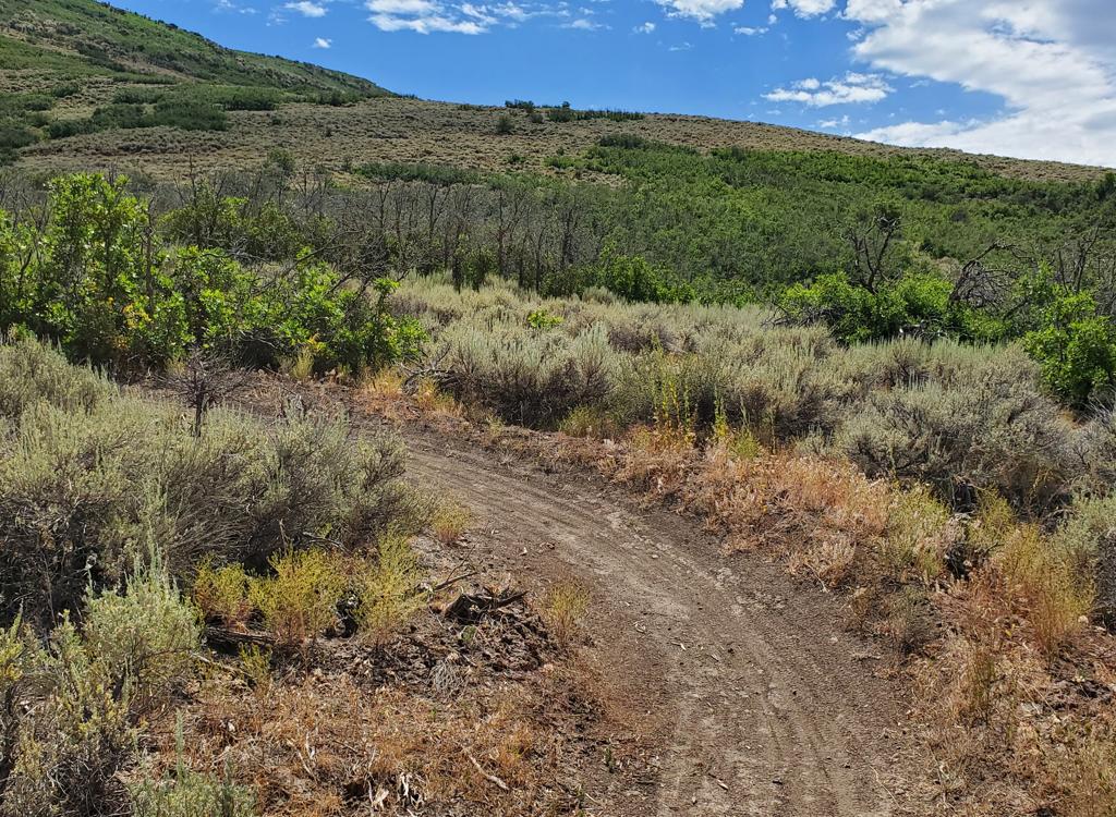
The trail is smooth and non-technical, with a gentle grade. The turns, and some sections of trail, have a bit of pitch that may give true beginners a problem. I'd rate the trail as early-intermediate in aerobic requirement and technical skill.
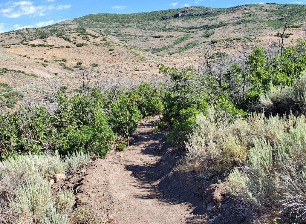
Upper Potatoes is 0.8 miles long, with 250 vertical feet of elevation change. When combined with Lower Potatoes as a continuous downhill, that's 1.2 miles and 350 feet of descent.


If you're arriving via the UVU Connector trail, it's going to be 1.6 miles climbing the Connector then 1.7 miles north on Riverview to reach the top of Upper Potatoes.


Lower Potatoes is very easy to ride, suitable for children and true beginners. If you have enough skill to arrive at the trail, you're skilled enough to ride it.


UVU Wasatch Campus trailhead: One mile south of the junction of Highway 40 and 32, turn east (toward the mountain) at the UVU campus. Northbound from Utah County, the UVU campus is a couple of miles north of Heber's business area. Go to the uppermost level of parking behind the UVU buildings and look for the step-over and kiosk. The singletrack UVU Connector trail climbs to Lower Riverview at mile 0.2 and Middle Earth at mile 0.7, then continues to the Riverview Trail at mile 1.6.
Trailhead options!
UVU Wasatch Campus Trailhead: One mile south of the junction of Highway 40 and 32 (a couple of miles north of Heber), turn east (toward the mountain) at the UVU campus. Go to the uppermost level of parking behind the UVU buildings. Look for the duck-under and kiosk. A singletrack trail climbs 1.5 miles to the Riverview Trail.
Wile E Canyon trailhead: The Wile E Canyon trailhead is located on the southern side of Highway 32, just over 4 miles from US-40. It's 1/10th mile east of the old Cutthroat trailhead (see below). There's room for about 8 cars here. From the parking lot, a connector trail takes you 120 yards uphill to the Wile E Canyon loop. To get to Beep Beep (or the Coyote Switchbacks or East Riverview), turn right at the trail fork, keep right at the next fork, then turn left onto the Coyote Riverview Connector trail as you approach the gravel road.
Coyote Riverview Connector trail (old Cutthroat): You can still connect through the old Cutthroat trailhead, although there's no longer a parking area here. For example, if the crowds have forced you to park where construction workers leave their vehicles along Highway 32, you can pedal to the gravel road to the new golf course leaves the highway, four miles east of US-40 and just east of the big rock-wall road-cut.
Puddy Tat parking: On Highway 3 around three miles from US-40, watch for a dirt road turning to the right in a huge sage meadow. There are a couple of buildings across Highway 32 at this spot. The parking spot is just through the fence, with a connection to Puddy Tat on the eastern side of parking. (This spot was still being worked on at the time of my review.)
Riverview trailhead: From US-40 just south of the Jordanelle reservoir, turn east at the traffic light onto Highwat 32 (at mile 14.2 from I-80 if you're coming from the north). On Highway 32, climb 1.1 miles. When you see the second entry into Riverview on your left and a road under construction to your right, the Riverview Connector trail starts on the uphill side of that road just after it leaves Highway 32. (In 2025, there's no longer protected parking here. It's unclear whether the trailhead will be restored when construction is complete.)Coyote Trailhead: The southern Coyote trailhead has been lost to subdivision construction. Access to the southern side the trail system is in limbo, but some riders find their way through the construction zone by pedaling up the gravel Coyote Canyon road.
Canal DT trailhead: Just uphill from the light on highway 32, watch for the canal crossing. Park along the road. Start riding south on the doubletrack just uphill from the canal.

Riding resources:
GPS track files (right-click and "Save as..."):
Multi-track GPX area
master file
Lodging, camping, shops:
Links to area resources
Trail pages:
Coyote Loop
Riverview Trail
page
Chop'd Coyote page
Lower Riverview page
Wile E Canyon page
Bathrooms: No public restrooms nearby.
Water: Gas stations in Heber, campgrounds.
Camping:
Hailstone campground at Jordanelle on US-40, about 6 miles away.
Bike services: Slim and Knobby's
bike shop, Heber