The trail rolls between outcops of colorful granite. Photos and review by Bruce ...
The trail rolls between outcops of colorful granite. Photos and review by Bruce on August 1, 2021.
Iron Springs and M&M Trails

The Iron Springs trail system lies on the southern slope of the Three Peaks riding area. It can be directly accessed from the Iron Springs Road near Cedar City, or via from the Three Peaks trailhead through to the Whale Trails . This page covers the cross-country trails on the east side of the system: Iron Springs and M&M. For info on the downhill flow trails to the west, see the Iron Springs DH page.

The trailhead on Iron Springs Road is at 5400 feet elevation, with the top elevation of the system at 5850. The lower elevations fall in clay and limestone, while the upper areas are the colorful rough granite for which Three Peaks is known. The expected riding season would be mid-April through November.
The trail is mostly dirt, but with frequent trips onto rock. It often takes a pr...
The trail is mostly dirt, but with frequent trips onto rock. It often takes a practiced eye to spot the riding line on the rock areas. If in doubt, keep straight.
Start of the trail. Note the big culvert under the railroad tracks ahead.
The Iron Springs trailhead is located at the Iron Springs resort. In the large gravel parking lot on the north side of the Iron Springs Road, the trail starts right next to the road on the far east side of the parking area. It descends through a culvert under the railroad, spends about 100 yards in a wash-bottom, then climbs out to cross a bit of sagebrush flat, then begins climbing the hill.

During a storm, the wash and culvert may not be safe to ride. Early spring and day-after storm riding may find deep sticky mud in the wash. There's a dirt road that offers a higher dryer passage over the railroad tracks. (See box below. The route is also shown on my map below.)

Iron Springs Trail
Initially, the trail is dirt ribbon among sagebrush, juniper and pinion. This lo...
Initially, the trail is dirt ribbon among sagebrush, juniper and pinion. This lower area is limestone soil and supports more plant life.
The Iron Springs trail is 2.6 miles long. It can be used for climbing or descending. Elevation change over the length of the trail is 400 vertical feet. It's an easy trail to ride, intermediate overall but suitable for strong experienced beginners.
The Iron Springs trail is used for access to the M&M Loop, the Petrified Whales trails, the Three Peaks Loop , and the Iron Springs DH trails. There are tons of riding options once you reach the top.
The trail begins to hit the intrusive igneous rock for which Three Peaks is know...
The trail begins to hit the intrusive igneous rock for which Three Peaks is known.
Looking back south, an old iron mine peeks above the junipers.
As mentioned above, access to the trail (and getting back to the trailhead) becomes dicey during storms. As you head up the hill on the singletrack, note the spot where you can take a road to stay on higher ground if the wash fills with water before your return trip.
Wet weather access: See the map below. From the parking lot, start eastbound on the dirt road parallel to the paved Iron Springs Road. Go 100 yards, then turn left on the ATV track. Cross the railroad tracks and close the gate behind you. Take the ATV track to a dirt road 0.2 miles from the highway and turn left on that road. Pedal 0.1 miles. (This same road reaches the climbing DT to the DH trails in another 0.3 miles.) When the singletrack crosses the road, turn right uphill. You're now at mile 0.3 of the Iron Springs singletrack. Once you're actually on the hill, mud is rarely a problem. The sandy dirt soaks up storms nicely. Do this route in reverse if a storm has ambushed you while on the hill.
At mile 1.7 from the trailhead, the lower limb of the M&M Loop forks off the Iron Springs trail to right. (See below for information on this trail.) It's marked only by a sign on your left identifying the Iron Springs trail (in 2021), positioned to be seen by riders coming clockwise on M&M. I suggest you ride past and enter the loop from above. It's only 0.4 miles ahead.
When in doubt about whats trail, keep straight.
When in doubt about what's "trail," keep straight.
Note the subtle Iron Springs sign in the shrub. This is the bottom of the M&M lo...
Note the subtle Iron Springs sign in the shrub. This is the bottom of the M&M loop. Here we're aiming downhill (south), so the M&M trail is to the left.
At mile 2.1 of Iron Springs, there's a marked trail fork with M&M turning off on your right. M&M is 2.8 miles long, and a loop around it clockwise will add 3.2 miles to your climb.

At mile 2.4 (mile 5.6 if you looped clockwise around M&M on the way up) keep left and uphill at an unmarked trail fork. The trail on the right drops down to a dirt road.

At mile 2.6 of Iron Springs (mile 5.8 of the ride if you looped around M&M), the trail ends on the southern side of the Petrified Whales loop. Note that if you're arriving at this spot via the Petrified Whales trail, you may not see Iron Springs unless you know exactly where it is. A dirt road crosses right where Iron Springs joins, and the trail marker is well-off the Petrified Whales trail.
Climbing higher. More pretty rocks.
Intersection with Petrified Whales, as seen from the top of Iron Springs. Unfort...
Intersection with Petrified Whales, as seen from the top of Iron Springs. Unfortunately, a dirt road crosses in this exact spot, making the trail less obvious.
So if you're coming from elsewhere in the Three Peaks riding area it's best to have a navigation app such as Trailforks to help you find the spot to turn downhill on Iron Springs. Signage may improve

Lots of ride options from here, including all the Whale Trails , Three Peaks Loop , and Four Loco.

A jaunt around Petrified Whales, and Moby Dick, and Humpback, and Jumbled Jonah is well worth the climb up Iron Springs. If you're looking for a short and fun out-and-back, that would be my suggestion.
On Petrified Whales heading north toward its origin on the Three Peaks Loop.
On Three Peaks, this is the spot where the connector heads south to the top of t...
On Three Peaks, this is the spot where the connector heads south to the top of the Iron Springs DH trails sYdwindErS and YES please.
If your destination is the top of the Iron Springs DH trails, turn left on Petrified Whales. Pedal 0.3 miles to the Three Peaks Loop and go left. (Take a minute here to make sure you actually got on Three Peaks and not Four Loco. Three Peaks westbound is the middle of three options at this trail fork.) Ride 0.7 miles on Three Peaks then turn left on the connector trail to the DH system. In 2021, it was marked by a trail sign in a juniper alongside the trail.
M&M Trail
Top of the M&M trail, seen as if descending on Iron Springs from Petrified Whale...
Top of the M&M trail, seen as if descending on Iron Springs from Petrified Whales. M&M is to the left, Iron Springs goes right.
The M&M trail is 2.8 miles long. It wanders among granite outcrops between its beginning and ending on the Iron Springs trail. Together with 0.4 miles of Iron Springs, M&M forms a loop. Most riders start on the uphill side and do the loop clockwise.
From top to bottom, the elevation changes from 5700 to 5600 feet, but there's a lot of up-and-down riding. A full trip around the loop (including the piece of Iron Springs) is 3.2 miles with 300 vertical feet of climbing.
The trail starts out with a lot of descending, then climbs as it turns back to t...
The trail starts out with a lot of descending, then climbs as it turns back to the east.
Rolling rock on M&M. Less-skilled riders need to at least have mastered the whol...
Rolling rock on M&M. Less-skilled riders need to at least have mastered the whole "get your butt off the bike seat" thing to ride this without bouncing out of control or pinch-flatting the rear tire.
The riding on the M&M loop is only slightly more technical than the Iron Springs trail. Officially I'd rate it intermediate, but I think a strong experienced beginner-level rider could do this.

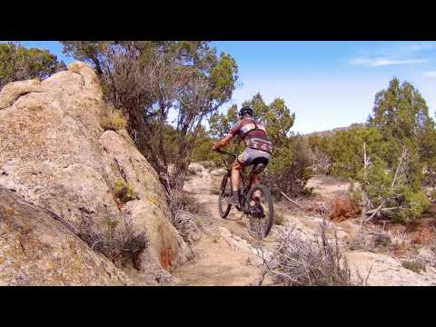
The markings and sight lines (seeing where the trail is going) work best when done top to bottom -- riding the M&M loop clockwise. You're way more likely to lose the trail temporarily if you ride up M&M from the bottom.

Both Iron Springs and M&M cross multiple dirt roads and ATV tracks. Keep straight when you hit roads and ATV-torn areas. Have faith and watch for singletrack coming up. Backtrack if you find yourself pedaling a road.

The rock areas are marked only by cairns and rock-lines. If you lose sight of the trail, hold straight and watch for any rocks that look "out of place." If after 30-50 feet you haven't seen the continuing trail, go back until you see you're clearly on the trail and look around for where you should have gone.

Section of trail straight ahead. Expect to be suckered occasionally by washes, A...
Section of trail straight ahead. Expect to be suckered occasionally by washes, ATV tracks, and tracks of folks who weren't paying attention.

Loop ride up Iron Springs and M&M, down YES Please...

[Back to video list ]
Iron Springs riding area
Getting there:

At the Cedar City 200 North Exit from I-15, go westbound on Highway 56. After 4.4 miles, just as the road is turning from straight west to southwest, turn right onto the Iron Springs Road (1740). Drive another 4.4 miles. As you see the big Iron Springs sign and flags on your left, look for a big gravel parking lot 200 yards ahead on your right. Turn into the parking lot and turn right to park along the eastern side. The outgoing trail starts on a broad dirt path alongside the paved Iron Springs Road. As soon as you pedal up onto this dirt path, immediately turn 90 degrees left onto singletrack. Descend into the wash and go through the tunnel under the railroad tracks. Follow the signs as the ATV path and bike trail split. (You can take the ATV path to the left to reach the DH trail system, or wait until Iron Springs crosses a dirt road and turn left there. To climb the Iron Springs trail, just follow the signs.)

Water at trailhead. No public bathroom (resort, campground, and restaurant facilities are for customers).

GPS track files (right-click and "Save as..."):
     Multi-track area Iron Springs
     Three Peaks multi-track
Topo map for printing:    Load above area topo
Lodging, camping, shops:     Links to Cedar City area resources