
Looking north from the BST, we can see vehicles on
the ridgeline at the trailhead for Hidden Lake. Review by Bruce on May
3,
2024.
Hidden Lake
The Hidden Lake trail connects the Bountiful Bench to the Bonneville Shoreline Trail (BST). From the trailhead just above Hidden Lake Circle, it's exactly one mile of mellow climbing to reach the BST. This trail splits the 8-mile BST between Wild Rose and North Canyon into equal 4 mile sections, creating new loop opportunities.
The Hidden Lake trail starts at 5900 feet elevation and
climbs to 6200 at the BST. Except for the first 150 yards, the trail lies on Forest Service land. In the spring, the Hidden Lake trail will dry
out faster than the BST. Rides using the southern BST (toward Wild Rose)
are usually dry in early May, while those connecting to North Canyon will
be at higher elevation and may not be ready until late May or June.

Rolling downhill through oak and balsamroot.
Trailheads and Access
 next to the sign.")
The trail is located at the gate (with a ride-around)
next to the sign.
Summerwood (water tank) Trailhead
From US-89, turn east on Eagle Ridge Drive. Stay on Eagle Ridge Drive past the golf course to Summerwood Drive and head uphill. Turn onto Hidden Lake Drive then turn at Hidden Lake Circle. At the end of the circle, continue uphill on paved road to the water tank and trailhead. Note that the building is for utilities -- it's not a bathroom. The trail entry is the doubletrack to the right of the building. Pedal uphill 100 yards and turn right on the singletrack.
From US-89, turn east on Eagle Ridge Drive. Stay on Eagle Ridge Drive past the golf course to Summerwood Drive and head uphill. Turn onto Hidden Lake Drive then turn at Hidden Lake Circle. At the end of the circle, continue uphill on paved road to the water tank and trailhead. Note that the building is for utilities -- it's not a bathroom. The trail entry is the doubletrack to the right of the building. Pedal uphill 100 yards and turn right on the singletrack.

The uphill trail is to the left of the bathroom.
From Wild Rose
From US-89, turn east on Eagle Ridge Drive. Stay on Eagle Ridge (straight) at the roundabout. Climb the hill for about two miles. Watch for Eaglepoint Drive on the right at N40 49.803 W111 53.771. (If you reach the golf course, you just missed it.) Drive 0.2 miles on Eaglepoint and turn left uphill on Sky Crest Lane. The parking lot is at the end of the road. Find the paved path to the left of the bathroom. Turn uphill and climb to the Bonneville Shoreline trail to pedal 4 miles north. (See the Wild Rose page for details.)
From US-89, turn east on Eagle Ridge Drive. Stay on Eagle Ridge (straight) at the roundabout. Climb the hill for about two miles. Watch for Eaglepoint Drive on the right at N40 49.803 W111 53.771. (If you reach the golf course, you just missed it.) Drive 0.2 miles on Eaglepoint and turn left uphill on Sky Crest Lane. The parking lot is at the end of the road. Find the paved path to the left of the bathroom. Turn uphill and climb to the Bonneville Shoreline trail to pedal 4 miles north. (See the Wild Rose page for details.)

A formal trailhead is planned for North Canyon.
From North Canyon
At the uphill end of Canyon Creek Road in Bountiful (reached via Bountiful Blvd), you can find roadside parking and begin pedaling uphill. You'll have the option of gravel service road or a singletrack trail on the right (south) side of the road 100 feet uphill from the gate. Pedal 1.5 relatively steep miles to the first BST trail fork and keep right on North Canyon. The southbound BST is 0.2 miles further uphill on the North Canyon trail. Fork right and go 4 miles to the south.
At the uphill end of Canyon Creek Road in Bountiful (reached via Bountiful Blvd), you can find roadside parking and begin pedaling uphill. You'll have the option of gravel service road or a singletrack trail on the right (south) side of the road 100 feet uphill from the gate. Pedal 1.5 relatively steep miles to the first BST trail fork and keep right on North Canyon. The southbound BST is 0.2 miles further uphill on the North Canyon trail. Fork right and go 4 miles to the south.
Hidden Lake Trail

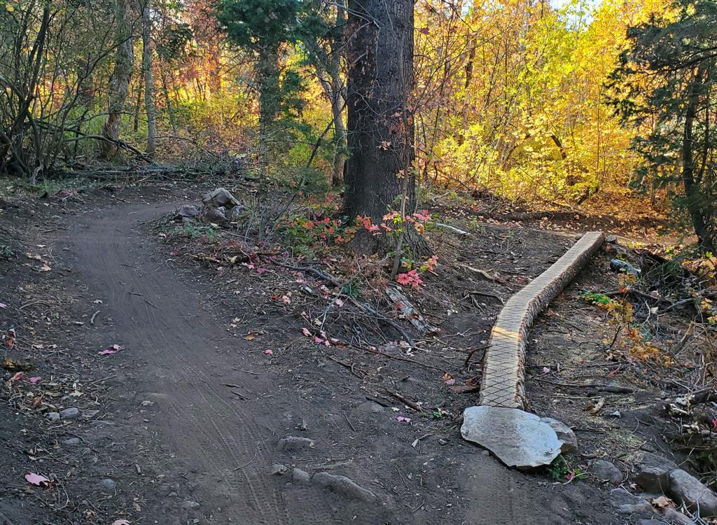
Looking west as Hidden Lake forks away from the BST.
The top of Hidden Lake lies on a grassy ridgeline at just
over 6200 feet elevation. It forks away from the BST at mile 4 from Wild
Rose's Viewpoint Trail and mile 4 from the North Canyon trail. At this
time (May 2024) the trail fork is not marked.
The bottom of the Hidden Lake trail is on doubletrack that
skirts around the water tank above the Summerwood trailhead parking
circle. (There are no trail signs here in May 2024.) Fork to the right on
the singletrack and begin climbing. It will be 300 vertical to the top
over one mile. The climbing is steady but at a gentle pitch.

The bottom of the Hidden Lake singletrack, as seen
from the gravel DT that's the first 100 yards of trail.

Bruce rolls around a hairpin. Note the outward camber
of the turn.
The trail winds back and forth through 10 relatively tight
turns. For most of these, the turn is flat and makes a good climbing turn.
But the flatness -- and even outward amber -- of most turns requires that
you shed a lot of speed on the downhill in order to safely whip around the
turn.
The trail runs through scattered oak groves with an
occasional bit of maple and chokecherry. The riding surface is smooth dirt
on a wide machine bench-cut trail.

Typical trail bench-cut through an oak grove.

Handlebar view to the west as we cruise the trail.
When the trail breaks out into grassy slope, you'll enjoy
nice views over the valley and Great Salt Lake to the west.

Looking down to the second hairpin turn of Hidden
Lake.
Bottom Line:
This trail is a game-changer for riders who use the BST above Bountiful. It's a pleasant trail to ride, with little excitement for the DH crowd, so most riders will use Hidden Lake as a climbing trail and descend North Canyon or Wild Rose. Nice views!
This trail is a game-changer for riders who use the BST above Bountiful. It's a pleasant trail to ride, with little excitement for the DH crowd, so most riders will use Hidden Lake as a climbing trail and descend North Canyon or Wild Rose. Nice views!
Getting there, Summerwood (water tank) Trailhead:
From US-89, turn east on Eagle Ridge Drive. Stay on Eagle Ridge Drive past the golf course to Summerwood Drive and head uphill. Turn onto Hidden Lake Drive then turn at Hidden Lake Circle. At the end of the circle, continue uphill on paved road to the water tank and trailhead. Note that the building is for utilities -- it's not a bathroom. The trail entry is the doubletrack to the right of the building. Pedal uphill 100 yards and turn right on the singletrack.
From US-89, turn east on Eagle Ridge Drive. Stay on Eagle Ridge Drive past the golf course to Summerwood Drive and head uphill. Turn onto Hidden Lake Drive then turn at Hidden Lake Circle. At the end of the circle, continue uphill on paved road to the water tank and trailhead. Note that the building is for utilities -- it's not a bathroom. The trail entry is the doubletrack to the right of the building. Pedal uphill 100 yards and turn right on the singletrack.

Map of the BST and Hidden Lake