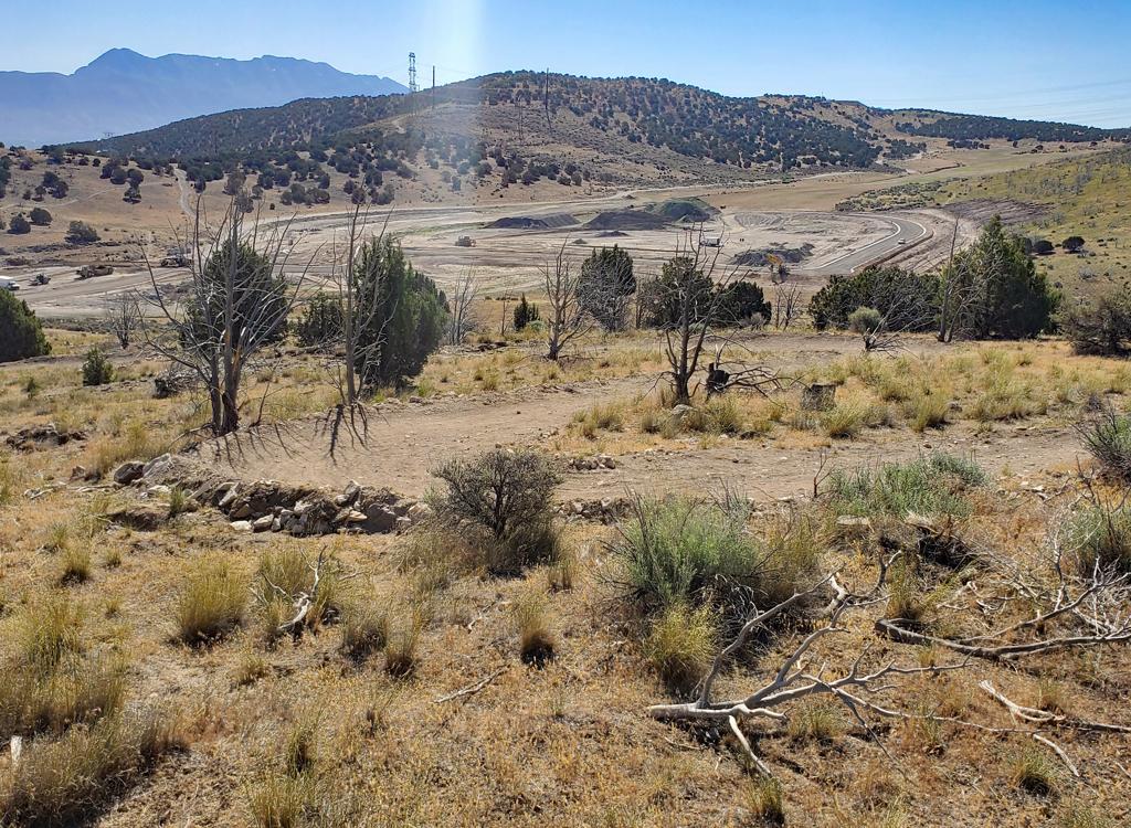
View northeast toward Chipman Peak and White Baldy from the eastern end of Stoney Way. Trail review by Bruce on December 10, 2019. Updated October 9, 2020.
Heritage Hills Trails
Stoney Way, Heritage Hills, Vista Ridge, North PointThese trails lie on the hillside north of Alpine. The area is mostly grass with occasional
groves of very short scrub oak. Stoney Way and Heritage Hills were built in 2019, with the
addition of Vista Ridge in 2020. Stoney Way connects the Schoolhouse Springs trailhead to the
Heritage Hills and Vista Ridge trails, with Vista Ridge climbing up to the Three Falls Fort
Canyon trail on the ridgeline and Heritage Hills descending to Alpine city.

Stoney Way slopes generally downhill from Heritage Hills to The Ridge trailhead, then uphill until its intersection with Bodily Harm.
Stoney Way is a traversing trail running east-west along the hillside above northeast Alpine.
It's 1.3 miles in length with a highest elevation of 5400 feet and low
point at 4850.
The riding is easy, suitable for beginners. There are no steeps or technical features.
On the east end, Stoney Way begins on the
Bodily Harm
trail, about 0.1 mile uphill from the Schoolhouse Springs biking trailhead. Fork left on the
lower trail. from here, Stoney Way runs downhill as it heads west.
From 5400 feet, it reaches its lowest elevation at 4850 at the midpoint in Big Hollow, where
it crosses a dirt road at the edge of a new subdivision under construction.
It then climbs
100 feet before ending on the Heritage Hills Loop, 0.5 miles uphill from
Heritage Hills' origin
on North Point Collector trail.

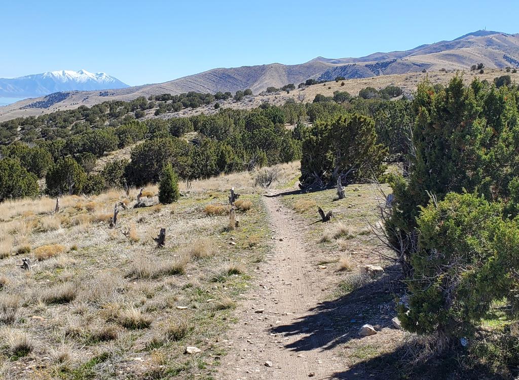
Heading southwest on Stoney Way as Bruce climbs toward Bodily Harm from The Ridge trailhead.

Looking northeast when the trail was first built, showing the bench-cut nature of the trail and the constant mountain views.
The trail is a bench-cut on slopes that have a moderate pitch. Because there are no trees of
any size to block your view, there's a lot of scenery to take in. To the
south is Utah Valley
and Utah Lake. The mountains of the Wasatch form a semi-circle around
you north and east.
In the middle of Stoney Way, at it's lowest point, a short connector descends to a trailhead
in The Ridge at Alpine subdivision. (There's no bathroom or water at this
trailhead.) This
is a nice spot to start the Heritage Hills loop ride.

Mountains everywhere. The big hill on the right is Box Elder Peak.
The mountains north of Alpine, as seen from the eastern edge of Lambert Park.
Mountains east of Alpine, as seen from the southwest corner of Lambert Park.
Heritage Hills - Vista Ridge Trails

Looking east toward East Mountain and Timpanogos.
The North Point Collector, Heritage Hills, and Vista Ridge trails are a continuous route from
the Heritage Hills (North Pointe) trailhead up to the Fort Canyon portion
of the Three Falls
trail. It's is a nicely constructed bench-cut trail with swooping bermed
turns. The slope is
moderate. It's 1.8 miles from the trailhead on Heritage Hills Drive to
the Three Falls Fort
Canyon trail.
North Point CollectorThe North Point Collector begins at the trailhead on Heritage Hills Drive. (There are no services
here, merely parking.) It climbs 1/4 mile before crossing the subdivision
road. At that point,
it becomes doubletrack. After another 100 yards, the Heritage Hills Loop
forks away to the
right, and the old doubletrack has been erased by construction.
At
mile 0.2 from the parking area, the trail has been destroyed by the leveling of a building
lot. Turn 90 degrees left and follow the edge until you reach a passage
between lots. From
here, head straight for the street, and the continuing trail is straight
across. (There was
storage of construction vehicles and supplies overtop of the trail here
during my last ride
here, so it may not appear like a trail to you.)

Heading uphill on the newly cut trail!

View to the south from just above the connection to Stoney Way. The downhill trail is seen near the grove of trees.
Heritage HillsFrom its origin at the top of the North Point Collector, Heritage Hills winds uphill. At mile
0.5, it connects to the west end of Stoney Way, while the uphill route
continues as Vista Ridge.
The trail climbs from 4700 feet to 4850 in 0.5 miles; a very reasonable
pitch. All but 100
feet of the trail lies on exposed hillside without shade. So it will be
a toasty climb on a
summer's afternoon.
Like Stoney Way, this part of the trail should be good for winter riding. The snow on this
slope usually melts away within days of a storm because it's highly sun-exposed.
But that also
means the frozen dirt surface will warm up and melt quickly if the sun
is out. Finishing the
ride before 10 a.m. is recommended!

The only oak grove high enough to give shade. 100 feet. Enjoy.

Nice view into the valley from the area where Stoney Way joins the uphill route from Heritage Hills.
Note fall 2020: At this time, the best way to access the Heritage Hills trail is to ride Stoney
Way from the
Schoolhouse Springs
area trails, or to connect from the Fort Canyon Three Falls trail. There's no good parking
in the under-construction subdivision at the bottom where it originates
on North Point Collector.
And the connection to the parking lot for the North Point Collector trail
on Heritage Hills
Drive has been severely impacted by construction. (If you get through,
it will be by walking
through not-trail and going rat-in-maze through construction equipment
and supplies to get
to the road where North Point Collector continues to the Heritage Hills
Loop.)
Vista RidgeThe Vista Ridge trail is the continuation of Heritage Hills at the point where Stoney Way intersects
the uphill route. This segment is 1 mile long, climbing 250 vertical feet
in the first 0.6
miles then descending a bit as it drops to the opposite side of the ridge
to connect to the
Fort Canyon Three Falls trail.

On Vista Ridge with Lone Peak as a backdrop.

Bruce approaches the saddle between Big Hollow and Fort Canyon.
Again here, the trail is a machine bench cut with a broad smooth riding surface. There are
no technical features. Some of the turns are a bit tight for beginners,
so this trail section
would rank lower-intermediate in skill level.
As Vista Ridge reaches the Three Falls trail, a hard right turn will take you uphill. In 0.7
miles, Three Falls will reach the Bodily Harm trail. If you then turn
right to descend Bodily
Harm, it will take you downhill to the Stoney Way trail near the Schoolhouse
Springs trailhead.
The loop of Stoney Way, Vista Ridge, and Bodily Harm has been called the
Heritage Hills Loop.

Riding south after leaving Three Falls on the counterclockwise Heritage Hills loop ride.

Looking southwest to Utah Lake and Lake Mountain.
At the top of Vista Ridge, you can also keep left to descend Three Falls to the Fort Canyon
trailhead. This trailhead has water and a bathroom.

Map of the Vista Ridge area.
Getting there:Schoolhouse Spring (Hammagog) Trailhead:
On Alpine's Grove Drive, head north to the second T intersection (where a right turn would
take you across the bridge into Lambert Park). Instead, turn left on Alpine Cove Drive. At
the 4-way intersection, turn left. As Alpine Cove Drive turns downhill, turn uphill on Aspen
Drive. It will turn to the Three Falls Lane road. As the paved road veers left to cross the creek, keep straight
onto a smaller dirt road and drive about 0.2 miles uphill until you hit the Lehi gate that
prevents further travel. Park, then coast back downhill to the paved road, pedal 150 feet uphill and fork onto the singletrack heading south on the left side of the road. After 1/10th mile, Stoney Way will fork left.
Heritage Hills (North Point): Shortly after you veer to
the northeast from Main onto Heritage Hills Drive as above, spot the small
parking lot on your left and turn in.
The Ridge TH (Stoney Way): At the T intersection of Grove Drive,
turn left. After 1/10th
mile, turn left again. Go 1/10th mile and turn right on Savannah Circle, then right into The
Ridge trailhead. You can take Stoney Way in either direction. South (left) will take you to the intersection of Heritage Hills with Vista Ridge. North (right) takes you to Bodily Harm.
Fort Canyon Trailhead:
As you drive into Alpine on
Main Street, keep straight at all intersections until you reach 800 North.
Then, just as Main Street turns to the right and becomes Heritage Hills
Drive, fork left on Fort Canyon Road to continue north. 0.9 miles later,
turn right just before the Three Falls entry. Turn left into parking.
This
is a major paved trailhead with water and a bathroom. From parking, climb
uphill 0.8 miles on the Three Falls Fort Canyon trail. The right fork
is
Vista Ridge, while left takes you up to the intersection of Bodily Harm
and Three Falls.