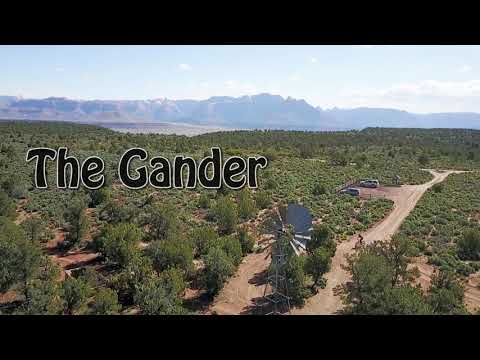
Looking east from the rim toward Zion Canyon. Photos and ride description by Bru...
Looking east from the rim toward Zion Canyon. Photos and ride description by Bruce, based on a ride November 17, 2010.
Gooseberry Northeast Rim
"The Gander"

This singletrack trail follows the northeastern edge of Gooseberry Mesa. It starts at the Windmill Trailhead and heads east along the rim. At the far eastern end, it will turn into the Grafton Wash trail. The length of the full singletrack is around 10 miles, but there are bailout doubletracks every couple of miles. A loop ride of the full Gander using the mesa road to return to the trailhead would be about 14.5 miles.

There are a lot of quick ups and downs, from a high of 5100 to a low of 4600 feet elevation. Total climbing at about 1300 for the full loop. The trail is typical Gooseberry singletrack meandering through the pinion and juniper, with lots of crunchy Shimarump conglomerate rock to navigate. It's modestly advanced technical, but can be handled by an intermediate with some short judiciously-chosen hikes.
One of the straighter sections of cliffside singletrack.
Looking east about half-way into the ride. Well follow each little side-canyon s...
Looking east about half-way into the ride. We'll follow each little side-canyon south, then return north to the edge again.
There are many quick little turns, but not as many up-and-downs as other trails on Gooseberry. So overall, the riding here is not as technical -- it's a cruiser compared to most other rides on the Goose. However, the track is narrow, and the brush is a little close to your arms. Arm warmers might be a good idea if you have tender skin.
To reach the Windmill parking area, fork right at the outhouse and drive a mile north. The Windmill parking is usually near-empty while the Cattle Grate trailhead is overflowing with cars. (You can also park at the toilet to begin this loop.)
Gene Poncelet rolls the rock edge along the northern cliffs of Gooseberry with t...
Gene Poncelet rolls the rock edge along the northern cliffs of Gooseberry with the Pine Valley Mountains in the background. February 2011.
View northwest.
View northwest.
Start the ride by heading toward the windmill, then turn 90 degrees right (north) on the singletrack. 0.4 miles later, the trail turns left along the rim. Don't go left. Notice the fainter singletrack heading east on your. That's your trail.
Critical navigation area!
At the viewpoint (the wide area where the mesa road ends), cross over and take the middle doubletrack. (The one closer to the cliffs (furthest left) seems the logical choice, but it doesn't connect to the singletrack. It goes to the Gooseberry rental yurt -- see our review page ) Within 0.1 mile, find the singletrack heading south. It crosses the doubletrack three times. Once you're on the ST, just keep riding.
The singletrack alternates between rough orange conglomerate, while sandstone, a...
The singletrack alternates between rough orange conglomerate, while sandstone, and a narrow dirt ribbon winding through the trees.
Bruce rolls around a point with Zion in the background. February 2011. Photo by ...
Bruce rolls around a point with Zion in the background. February 2011. Photo by Gene.
The trail constantly returns to the cliff edge for 8 miles, then begins a descent into a fork of Grafton Wash. Now you have a navigation decision. You can bail out on the DT at mile 8.5, or descend toward Grafton Wash for a slightly longer ride. The shortcut via the DT cuts a mile off the loop, and eliminates a tough climb up to the corral (see below).

NOTE: Until land-permission issues are worked out, I suggest you take the shortcut above and bypass the corral. This gives you a 12.5 mile ride, missing only a tiny bit of the singletrack.

If you went down into Grafton Wash, decide whether to head back via the corral, or to climb up to Grafton Mesa for a significantly-longer ride. (On your left, cairns mark a trail that continues left downhill. That trail crosses Grafton Wash to Grafton Mesa , with connections to the Grafton Mesa singletrack "social trails.") Another trail starts uphill by the end of the fence on your right. That's the one you want for the loop. Continue on DT after the corral. When you hit the mesa road, pedal 4.1 miles back to parking.
Getting there. This is the right fork of Grafton Wash. The band of Moenkopi slop...
Getting there. This is the right fork of Grafton Wash. The band of Moenkopi slope is called Pastry Ridge.

An April cruise on The Gander trail!

[Back to video list ]
map
Map of the northeast edge of Gooseberry.
Getting there -- North: As you approach Zion National Park in Rockville, turn south (right) on Bridge Road. After crossing the Virgin River, the dirt road winds up the mesa. Keep left at the fork at 1.5 miles. Continue to a total of 6.2 miles, where you turn right at a sign "Gooseberry Mesa." Another 3.6 miles after the turnoff, take the right fork as you pass the outhouse. One mile later, you'll see a windmill on the left side of the road. Turn into the parking area at the windmill GPS N 37° 09.090' W 113° 09.973'.
Getting there -- South:
As you pass through Hurricane heading east, turn right at the Highway 9 sign. (If you start exit town without making a right-turn, you went past it.) One block later, turn left and drive out of town. About 15 minutes later, you'll pass a gas station on the left-hand side, then some fields. Watch for a "Scenic Byway" sign, and turn left onto a dirt road. Two miles later, just as you reach the mountain, the Gooseberry Mesa road turns off on your left. Another 3.6 miles after the turnoff, take the right fork as you pass the outhouse. One mile later, you'll see a windmill on the left side of the road. Turn into the parking area at the windmill GPS N 37° 09.090' W 113° 09.973'.
Riding notes, clockwise loop:
0.0   West from parking N37 09.090 W113 09.940
         Turn right at the sign N37 09.091 W113 10.004
0.4    Right as trail turns 90 degrees L
         N37 09.346 W113 10.112
0.6    Cross view area, take middle DT
         N37 09.424 W113 09.993
0.7    Leave DT for southbound ST
         N37 09.414 W113 09.921
1.5    Straight. DT on R bails out
         N37 09.165 W113 09.505
4.9     Cross fence 
         N37 08.581 W113 08.213
4.9    Cross fence 
         N37 08.581 W113 08.213
8.5    Cross DT for long loop, R on DT for 12.5 mi loop
         N37 08.366 W113 06.607
9.1    Cross wash, R uphill (9.0 by GPS)
         N37 07.953 W113 06.496
9.6    Pass through or around corral (9.4 by GPS)
         N37 07.706 W113 06.798
10.4  R on mesa road (10.2 by GPS)
         N37 07.225 W113 06.935
11.2  Pass bailout DT (from mi 8.5) N37 07.826 W113 07.190
13.5  R at bathroom
14.5  Back at parking

Option:   Tour de Rim. The Whole Gander .    This will give you a ride of over 30 miles. It's brutal. Begin the ride as above. When you reach the outhouse, keep left and ride to the Cattle Grate trailhead on the White Trail . Turn left onto the Cattle Grate trail. Keep going into God's Skateboard Park, then turn east on the Secret Trail . Connect to the South Rim and head to the Point. Now start east on the White Trail, with a detour onto the Yellow Trail, then take the North Rim to Rim Job (the northern limb of the Windmill Loop ). 

Riding resources for this trail:
Single-page riding guide
GPS track files (right-click and "Save as..."):
     12.5 mi NE Rim Loop
     Longer Loop
     Tour de Rim, The Whole Gander
Topo map (600K) for printing:   Click here
Lodging, camping, shops:   Links to St. George area resources