
with Upper Frodo and Doors of Durin
Frodo's Playground, Upper Frodo, and Doors of Durin are downhill-only trails in the Coyote (Riverview) trail system north of Heber. They lie directly uphill from the UVU Wasatch Campus trailhead, so it's a quick and non-strenuous climb to arrive at the top. The riding varies from very easy on Frodo's Playground to very difficult on Doors of Durin.
The expected riding season would be late April through October.
The trail includes rock roll-overs and wooden ramps. These stunts in the trail are intermediate in difficulty. But easy ride-arounds for the stunts make Frodo's Playground suitable for beginners and families.


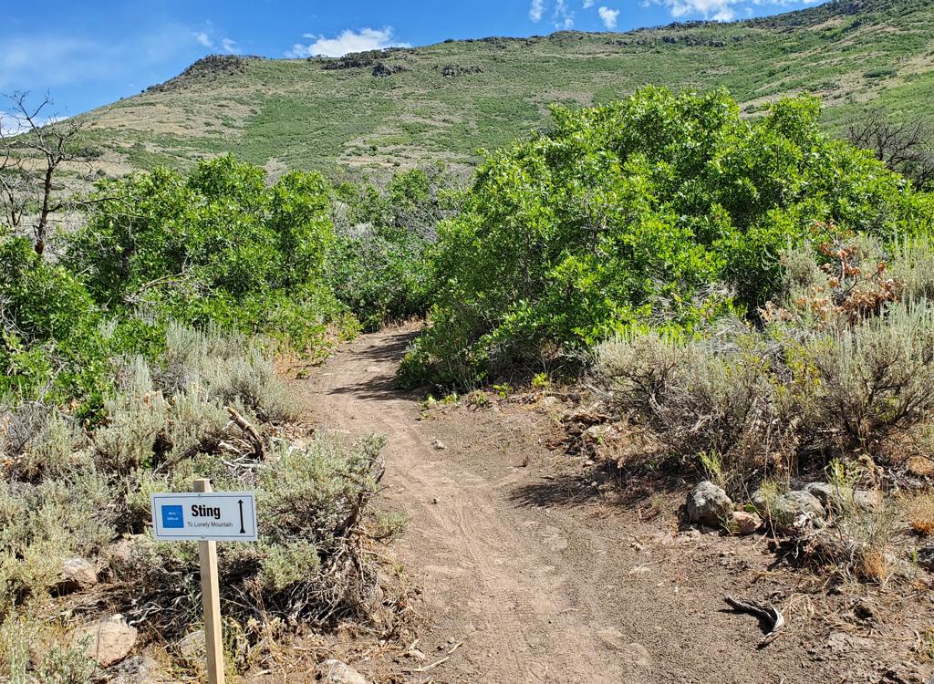
Upper Frodo is 0.7 miles long, and is easier-intermediate in difficulty. Upper Frodo continues as Frodo's Playground when it crosses Middle Earth, for a total downhill of 1.2 miles back to Lower Riverview. A loop up UVU Connector, down Upper Frodo and Frodo's Playground and back to the trailhead is 3 miles.
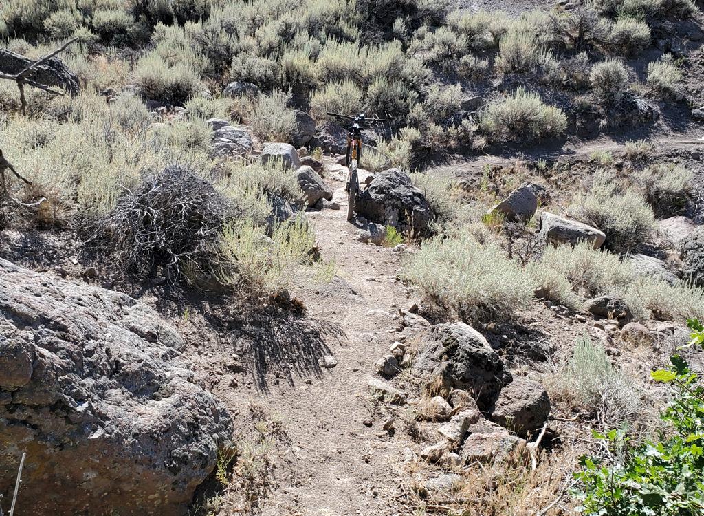
Doors of Durin is a narrow hand-built trail. It has rock rollovers and some steep rough stretches, with no ride-arounds to the technical spots.


UVU Trailhead
Most riders get to the Riverview area west-side trails from the UVU
Wasatch Campus trailhead. This is found on the far north end of Heber on
Highway 40, one mile south of the Highway 32 junction. At the UVU campus
entry, turn
east (toward the mountain). Go to the uppermost level of
parking behind the UVU buildings. Look for the duck-under and kiosk.
The UVU Connector trail climbs uphill from the trailhead to the Upper Riverview (Rivendell) trail. On the way, it crosses the easy rides on Lower Riverview, the Riverview Doubletrack, and Middle Earth. Lower Frodo's Playground is reached via a right turn onto Middle Earth at mile 0.7 from the TH. The new upper Frodo is at mile 1.2 on the UVU Connector. ( This trailhead is also closest to the beginner skills area trails at Lower Potatoes and Isengard.)


South Coyote Trailhead (CLOSED AT TIME OF REVIEW)
You can get to Frodo's Playground from the south. Connect to
Middle Earth for the northbound trip. Note that this trailhead has
been affected by construction, and may not be available. If you can find your way uphill, you can take Sheep Pen to Middle Earth.

Riverview Trailhead
On US-40 north of Heber, turn east on Highway 32 and climb 1.1 miles. When you see the second entry into
Riverview on your left, note the gravel parking area on your right. That's
your spot. Take the 0.3-mile connector to Upper Riverview and head 3 miles
south to the UVU Connector trail.

Upper Frodo descends as a wiggling bench-cut from Upper Riverview downhill. There are two table jumps that you can ride around, and a few optional rock launching pads. Turns are banked for speed.
While officially rated intermediate, Upper Frodo is suitable for beginners. You can ride around any stunts on butter-smooth trail. Upper Frodo rides like a flow trail, with fewer stunts and rock roll-overs than on Frodo's Playground.


You'll cross the UVU connector about half-way down.
Upper Frodo's continues as Frodo's Playground when it hits the Middle Earth trail. The Upper Frodo portion of the descent is 250 vertical feet over 0.7 miles. The combined ride is 1.2 miles with 350 feet of elevation change.

Turns are banked and flow smoothly. The trail is 0.5 miles in length, descending only 150 vertical feet at a gentle and constant rate.
It's easy to flow down this trail on butter-smooth dirt with hardly a bump if you take the easy way around every stunt. So Frodo's Playground is suitable for mixed-ability groups and kids.


Frodo's Playground has several rock challenges and wooden ramps that would be rated intermediate. There's a final narrow hump-ramp that I would rate expert. All of these stunts have easy ride-arounds.
Once you're on the mountain, a loop around lower Frodo's and back to the top is just under one mile with 150 feet of climbing.

Bottom Line
Very nice trail that's easy to reach and easy to ride. Suitable for groups of mixed ability and families with younger kids.

But wait for it...


Getting there, UVU Wasatch Campus Trailhead:
One mile south of the junction of
Highway 40 and 32 (a couple of miles north of Heber), turn east (toward the mountain) at the UVU campus.
Go to the uppermost level of parking behind the UVU buildings. Look for the
duck-under and kiosk N40 32.798 W111 24.735. A singletrack trail climbs 1.5 miles to the
Riverview Trail.
Trailhead options!
UVU Wasatch Campus Trailhead: One mile south of the junction of Highway 40 and 32 (a couple of miles north of Heber), turn east (toward the mountain) at the UVU campus. Go to the uppermost level of parking behind the UVU buildings. Look for the duck-under and kiosk. A singletrack trail climbs 1.5 miles to the Riverview Trail.
Wile E Canyon trailhead: The Wile E Canyon trailhead is located on the southern side of Highway 32, just over 4 miles from US-40. It's 1/10th mile east of the old Cutthroat trailhead (see below). There's room for about 8 cars here. From the parking lot, a connector trail takes you 120 yards uphill to the Wile E Canyon loop. To get to Beep Beep (or the Coyote Switchbacks or East Riverview), turn right at the trail fork, keep right at the next fork, then turn left onto the Coyote Riverview Connector trail as you approach the gravel road.
Coyote Riverview Connector trail (old Cutthroat): You can still connect through the old Cutthroat trailhead, although there's no longer a parking area here. For example, if the crowds have forced you to park where construction workers leave their vehicles along Highway 32, you can pedal to the gravel road to the new golf course leaves the highway, four miles east of US-40 and just east of the big rock-wall road-cut.
Puddy Tat parking: On Highway 3 around three miles from US-40, watch for a dirt road turning to the right in a huge sage meadow. There are a couple of buildings across Highway 32 at this spot. The parking spot is just through the fence, with a connection to Puddy Tat on the eastern side of parking. (This spot was still being worked on at the time of my review.)
Riverview trailhead: From US-40 just south of the Jordanelle reservoir, turn east at the traffic light onto Highwat 32 (at mile 14.2 from I-80 if you're coming from the north). On Highway 32, climb 1.1 miles. When you see the second entry into Riverview on your left and a road under construction to your right, the Riverview Connector trail starts on the uphill side of that road just after it leaves Highway 32. (In 2025, there's no longer protected parking here. It's unclear whether the trailhead will be restored when construction is complete.)Coyote Trailhead: The southern Coyote trailhead has been lost to subdivision construction. Access to the southern side the trail system is in limbo, but some riders find their way through the construction zone by pedaling up the gravel Coyote Canyon road.
Canal DT trailhead: Just uphill from the light on highway 32, watch for the canal crossing. Park along the road. Start riding south on the doubletrack just uphill from the canal.