
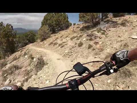

Winding along the trail, looking south. Trail review by Bruce on May 1, 2023.
Fireman's Trail in Manti"The M Trail"
The Fireman's trail lies right on the edge of Manti, climbing up the hill to the east of town. If offers a 3.8-mile out-and-back to the big "M" on the hill, or a less-popular 5-mile loop ride. It's an upper-intermediate trail with some steep side-slope exposure and a couple of nervous bridge crossings. While not a "destination" trail, it's certainly worth doing if you're in the area.
The Fireman's trail lies right on the edge of Manti, climbing up the hill to the east of town. If offers a 3.8-mile out-and-back to the big "M" on the hill, or a less-popular 5-mile loop ride. It's an upper-intermediate trail with some steep side-slope exposure and a couple of nervous bridge crossings. While not a "destination" trail, it's certainly worth doing if you're in the area.
The trail climbs at a fairly steady pace for 800 vertical feet. Your turn-around spot can be
either the ridge viewpoint at mile 1.7, or the "M" at mile 1.9 from the trailhead.If you continue north past the "M" the trail becomes increasingly sketchy. It will join a dirt
forest road at mile 2.7, which descends to a larger dirt road just northwest of the trailhead
for the loop ride option.

On the lower mountain, the terrain is mostly juniper on clay with rare low shrubs.
Trailhead

At the trail entry. That's the trail heading uphill in the center of the photo.
The trail can be tricky for newcomers to find. On US-89 in Manti, take 300 North east toward
the mountain. At mile 0.5 300 East will veer to the right and become dirt. As the dirt road
passes to the south of a small hill at mile 0.9, turn right on a smaller dirt road that ramps
uphill to arrive at a retention pond. Go straight past the pond then turn 150 degrees right
uphill. At mile 1.2 there's primitive parking on the left (uphill) side of the road, with the
trail at the south end of parking. (See the map below.)
Fireman's Trail to the M

Meandering through the junipers as we start to climb.
The trail begins in a juniper forest. The slope gets steeper after the first 1/4 mile. The
next 1/2 mile will be the hardest climbing. Overall, you'll be climbing between 800 and 850
vertical feet, depending on whether you turn around at the viewpoint or go further to the "M".
There will be intermittent views to the west over Manti as you climb. The trail wiggles around
enough that it stays interesting.

View from around mile 0.5 shows the bare ground between junipers, with the Manti Temple at mid-photo.

As we get further up the hill, there are occasional outcrops of rock at trailside, but the trail surface remains dirt.
The track is relatively narrow, and there are some steep side-slopes with loose cobble. Passing
horse riders or hikers can be inconvenient.
As you get higher, junipers give way to pinion pine and fir.

Approaching the viewpoint area, riding south.

At the viewpoint, looking east up Manti Canyon toward Manti Mountain.
At the viewpoint at mile 1.7, the trail arrives at a line of south-facing cliffs. The valley
is Manti Canyon, a popular recreation spot, and to the east is Manti Mountain.

Looking south down the ridgeline from the viewpoint.

West across Manti from the viewpoint.

The trail cuts across the bottom of the M. We're looking north. Somebody has remodeled a bit of the "M" into a chair.
At the ridgeline, make a sharp left turn to climb further uphill. The trail will then traverse
the hillside for 0.2 miles until you reach the "M". The M is formed from slabs of white rock,
and if you don't realize what you're looking at, you may think you're simply riding past the
bottom of a rockslide. This is where most riders turn around for the out-and-back. If you continue
on, it will be 0.7 miles to the dirt road downhill for a loop ride.
The downhill can be challenging for less-confident riders. The track is narrow, and with the
steep side-slope it's relatively unforgiving. Some turns are tight, and stumps and overhanging
trees may need dodging at inconvenient times. It's on the downhill that this trail earns its
upper-intermediate rating.

Approaching a bridge on the way down.

No bathroom, water, or camping at trailhead.
Getting there:
On US-89 in Manti, take 300 North eastbound. At mile 0.5 it will veer to the right and become dirt. As the dirt road passes to the south of a small hill at mile 0.9, turn right on a smaller dirt road that ramps uphill to arrive at a retention pond. Go straight past the pond then turn 150 degrees right uphill. At mile 1.2 there's primitive parking on the left (uphill) side of the road, with the trail at the south end of parking.
On US-89 in Manti, take 300 North eastbound. At mile 0.5 it will veer to the right and become dirt. As the dirt road passes to the south of a small hill at mile 0.9, turn right on a smaller dirt road that ramps uphill to arrive at a retention pond. Go straight past the pond then turn 150 degrees right uphill. At mile 1.2 there's primitive parking on the left (uphill) side of the road, with the trail at the south end of parking.
Riding resources for this trail:
GPS track files (right-click and "Save as..."):
Fireman's Trail track
Lodging, camping, shops:
Links to south Utah Co resources
GPS track files (right-click and "Save as..."):
Fireman's Trail track
Lodging, camping, shops:
Links to south Utah Co resources


