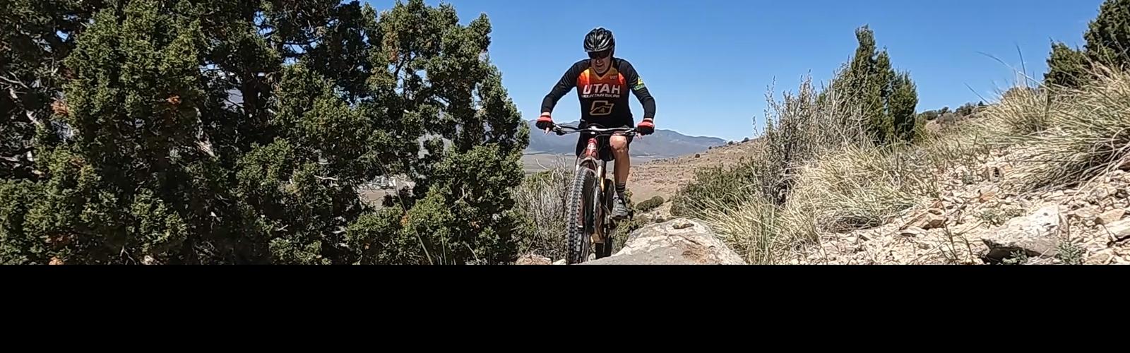
View northwest from Cliffside. Review rides by Bruce on May 3 and May 6, 2026.
Eagle Mountain West
Fair 'n Square, Valley View, Cliffside, AC-DC, Chasing The Sun, Samsara
The trails on the far-western slope of Lake Mountain are largely
unknown by riders from outside Eagle Mountain because they do not connect
directly to the main trail system (at the time of this review in 2026). There are
several trails here, ranging from easy to upper-intermediate in skill requirement.
The elevation starts at 5100 feet, with a summit of around 5700 at the
top of Chasing The Sun. The expected riding season will be April through
November.
The terrain is mostly sage brush on the lower slopes, with patches of
juniper and bitterbrush in ravines and on upper slopes. Most of the area is fully sun-exposed and can get
toasty in the summer.
Most riders are using the trails as out-and-back routes.
It's possible to create a loop ride on the lower trails by combining ATV path.
But navigation for
these loop routes will be difficult for those who aren't native to the
area.

Bruce cruises through sage and wildflowers on Valley View.

Looking south uphill on Cliffside.
There are two main routes. The first is a fairly-easy
singetrack ride on the lower mountain for beginners and
early-intermediates, composed of 4 named trails The second is Chasing The Sun, a much longer and
tougher ride that requires upper-intermediate or expert skill and
strength.
(1) Traversing route. The traversing trail connects the Eagle
Mountain Parkway trailhead to northern Deadwood. This route runs low on
the mountain, consisting of Fair 'n Square, Valley View, Cliffside, and
AC-DC. Usually done as an out-and-back.
(2) Chasing The Sun. This trail extends from the northern end of
AC-DC up to the top of the hill. It can be done as a loop (for strong
riders who
know the area) or an up-and-back. The recommended ride is
counterclockwise, climbing Chasing The Sun then descending a combination
of Samsara, doubletrack, either Eastwood or Fistful of Dollars, then Deadwood back to AC-DC.
On this page, I'll discuss the easy lower-elevation trails first, then
the Chasing The Sun to Samsara route.

Bruce climbs Chasing The Sun. We're looking west.

Hidden Hollow parking lot, looking southeast
Hidden Hollow TrailheadThe paved Hidden Hollow trailhead has a bathroom, water, and room for over 40 vehicles.
Westbound on SR-73 from Redwood Road (11600 West) in Lehi or from the
Mountain View Corridor, turn left at the stop light onto The Ranches Parkway.
At Pony Express Parkway, turn right. The road will veer a bit south
(left), then back west (right) as you get one mile from Ranches Parkway.
At the traffic light before Hidden Hollow
Elementary, turn left and drive uphill 0.3 miles. Turn left into the
parking lot.
To reach the west-side trails, most riders would navigate to the
western end of Treadstone or Backspacer (or northern end of Deadwood) to
enter AC-DC from the north.
You can also park at the Rockpile race staging area and
pedal south, then west to the slot between the hills where the power lines
go through the valley. There's a bit of off-road parking here, although no
formal cleared area for cars.
However you arrive, find the spot where Deadwood crosses a gully and
two dirt roads to reach Treadstone. Turn left and climb south uphill about
100 feet up the gravel ATV road to a third east-west doubletrack, where
you'll turn right to go westbound. (Don't keep climbing the trail that goes
uphill.) The entry to AC-DC is on your left in around 0.2 miles, just
after the dirt road splits.

Here's the origin of the singletrack AC-DC from the doubletrack portion, looking southwest.

Eagle Mountain Parkway trailhead. The singletrack is just to the right of this photo.
Eagle Mountain Parkway TrailheadFrom either Highway 73 or from Pony Express Parkway in Eagle Mountain,
turn onto Eagle Mountain Parkway and drive to the eastern end of the road.
Veer to the left at the end of the road and drive uphill through the gate
and cattle-guard. Find a spot to park.
Note the circle to the uphill left of the entry. Two
doubletracks climb the hill as they leave the circle. Between them is a
singletrack. This is Fair 'n Square, which is your route uphill. Around
100 yards uphill, the trail will split. To the right is Fair 'n Square,
which I recommend as your climbing route. The trail on the left is Three
Trees, which will cross Valley View on its way uphill to the Coyote Canyon
Access doubletrack.

The singletrack starts from the loop between two doubletracks.
Easier Lower-elevation Trails
Fair 'n Square

Looking northeast as we climb.
The Fair 'n Square trail climbs from the Eagle Mountain
Parkway trailhead to the Valley View trail. It's two-way singletrack, 0.5
miles in length with 100 vertical feet of elevation gain as it climbs
east.
The terrain is 100% sage brush. It's a very easy ride, suitable for
beginners.
There are no trail signs at the time of this review. To
navigate uphill, keep right at the first singletrack trail fork (left is
Three Trees). Keep right again as Hillside forks left. You'll rejoin
Hillside (coming in on your left) near the top.
Just past the Hillside merger, you'll ride past a cement cellar ruin.
At the next trail fork go to the left as the Ravine Ridge trail goes
uphill right. The path will now change from generally eastbound uphill to
northbound traversing as you continue on the Valley View trail.

At this spot, Hillside and Fair 'n Square have rejoined. We'll veer left at the next trail fork for Valley View.

Descending Hillside heading southwest.
The Hillside trail is a singletrack alternate to Fair 'n
Square for either climbing or descending. Climbing on Fair 'n Square,
Hillside is the second trail on your left. It will rejoin Fair 'n Square
just before the cement cellar foundation described above.
Hillside is 0.3 miles long, with a very mellow rate of elevation
change, gaining only around 30 vertical feet in the uphill (eastbound)
direction.

Climbing uphill on Ravine Ridge. Note that it's significantly less-traveled than the other trails.
Ravine Ridge forks to the right from the top of Fair 'n
Square, 0.5 miles from the trailhead. At the time of my review, it's
obviously a less-traveled trail than Fair 'n Square or Valley View.
Ravine Ridge climbs east uphill to join the Wiley Canyon Access
doubletrack road. It's 0.6 miles long with just under 200 vertical feet of
elevation gain in the eastbound direction.
Just 20 feet from where Ravine Ridge ends on the Wiley
Canyon doubletrack, the Three Trees trail starts as a doubletrack heading
west downhill.
The combined route of Fair 'n Square plus Ravine Ridge is 1.1 miles
with 300 feet of elevation gain.

Arriving at the canyon doubletrack.
Canyon Access Doubletrack

View north on the Wiley Canyon Road.
The Wiley Canyon Access doubletrack road provides southbound
miles, or a northbound connection directly to the Cliffside trail. (The
spot where the singletrack crosses Wiley Canyon Road is where it changes
from Valley View to Cliffside.)
Riding northbound (keeping to the left as you exit upper Ravine Ridge),
it's 0.7 miles on the doubletrack to reach the singletrack Cliffside trail
as the traversing route crosses the doubletrack. You'll climb a small
amount at first, then descend around 150 vertical feet as you approach
Cliffside.
The Three Trees trail is a fairly direct route from the
trailhead area up to the Wiley Canyon Access Road. It's a combination of
doubletrack and singletrack, with spots where singletrack options cross
and re-cross the doubletrack. It forks to the left from Fair 'n Square
just above the trailhead then climbs at a steady pace for 0.7 miles and
250 vertical feet to reach the Wiley Canyon Road just a few feet north of
the junction with Ravine Ridge.

Descending Three Trees toward the city center of Eagle Mountain.

Northbound on Valley View.
Valley View is the southernmost of three sections of
singletrack that traverse the western flank of Lake Mountain, starting
just east of the Eagle Mountain city center area. The traversing route
consists of Valley View, Cliffside, then AC-DC.
Valley View is 0.9 miles in length. When done northbound,
there's 50 feet of elevation gain as the trail gently undulates along the
slope.
The trail lies on a sun-exposed sagebrush slope. The track is mostly
smooth dirt and is suitable for beginning riders.

View to the northwest.

Looking south.
When Valley View crosses the Wiley Canyon Access doubletrack
road, it becomes the Cliffside trail. Here the trail becomes a bit more
technical due to increased slopes, loose track, and occasional rocks. This
is a good spots for kids and beginners to turn around.

Northbound as we reach the rock ledges of Cliffside.
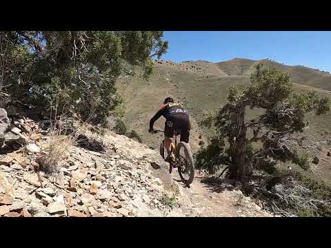
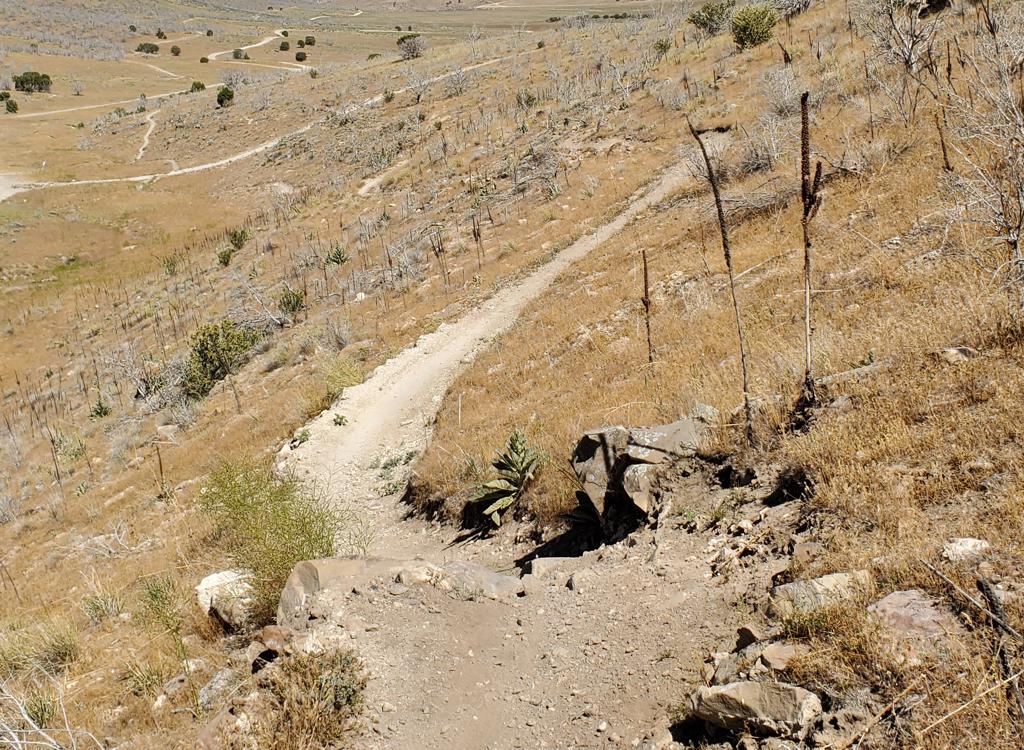
The Cliffside trail is the middle segment of the traversing
route on western Lake Mountain. It extends from the end of Valley View on
the Wiley Canyon doubletrack road to the Ridge Connector ATV route.
The Cliffside trail is 1.1 miles in length. There will be
some up-and-down riding near the northern end, with around 150 feet of
climbing when done in either direction. This trail would rank intermediate
in skill requirement due to occasional loose track, embedded rock, and
minor cliff exposure.

View south on Cliffside.

Rolling a turn.
In the northbound direction, Cliffside will cross another
ATV track around 0.2 miles after you left Valley View for Cliffside at the
Wiley Canyon Road. The navigation here is fairly obvious.
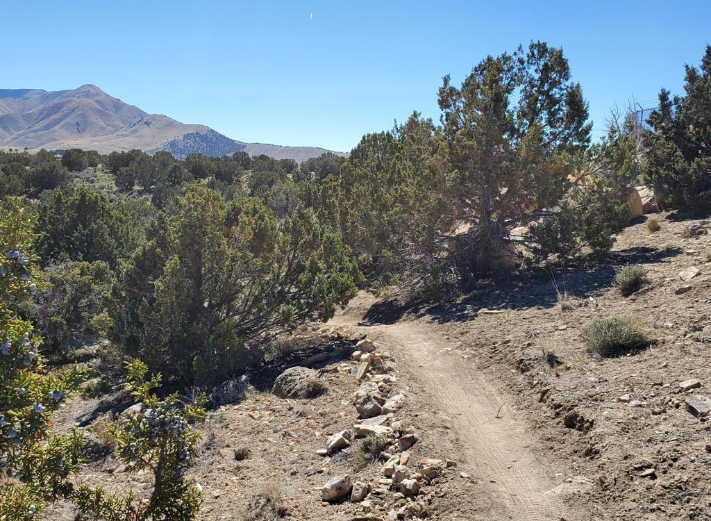
Cliffside has a combination of grassy sage, juniper, and bitterbrush
slope.
At the northern end of Cliffside, after descending along the
cliff edge, the trail will turn east and climb back uphill. Then it will
again drop. As you hit the doubletrack in the ravine at the bottom of the
descent, turn to the left westbound on the ATV road. After about 100 feet,
veer to the right uphill on singletrack. You're now on AC-DC.

Cliffside is my favorite section of this ride.

Crossing a grassy meadow northwest as we start AC-DC.
AC-DC is the northernmost of the three trails that traverse
the western slope of Lake Mountain. It's an easier-intermediate
singletrack with a few spots of doubletrack thrown in along its length.
The trail extends from the connector ATV track in the ravine (at the south end)
to end on gravel doubletrack at the northern end of the Deadwood trail,
across from Treadstone and Backspacer.
AC-DC is 0.9 miles long including the dirt-road pieces, with a general
downslope as you go north and east. It will curve from northbound to
eastbound as you enter the connector canyon along the power lines.
The terrain on the southern half of AC-DC is mostly grass
and dirt. The northern and eastern side has thick sage brush with
occasional juniper.
The navigation is obvious when done south-to-north, but the
tricky when you're trying to find AC-DC from the Hidden Valley side of the
Eagle Mountain trail system.

As we hit the power lines, the singletrack merges onto the powerline access doubletrack.

Rolling past a limestone outcrop on northern AC-DC.
Northbound, AC-DC will drop onto doubletrack under the power
lines after 0.3 miles. It will then exit left onto singletrack again at
mile 0.4. Keep straight and left as you pass the trail fork for Chasing
The Sun on your right at mile 0.5. The singletrack will join gravel road
eastbound around mile 0.8 before coming to a T intersection. Beyond the T
is the end of Deadwood. Downhill and across the ravine is Treadstone. Two
dirt roads lie in the ravine below you. Westbound, they'll take you out to
civilization. Eastbound, they can take you to the Rockpile parking area.
To ride AC-DC southbound (or to reach the trail fork for
Chasing The Sun), go to the western end of Treadstone, Backspacer,
Beggar's Canyon, or Deadwood. Find the ATV path that crosses the ravine to
climb the hill southbound. Go uphill a little to the 3rd of three ATV
paths that go east-west. Turn right and pedal the ATV route until you find
singletrack forking to the left (uphill) side of the ATV road.
The first trail fork you reach (at around 1/4 mile) is the expert-level
plunge called Around The Fur, to your left. Keep right. Then at mile 0.4
from the ravine, Chasing The Sun forks left uphill. Keep right for AC-DC.

A tiny bit of slickrock riding in a wash as we approach the Deadwood area.
More Difficult Riding
Chasing The Sun

To the left uphill is Chasing The Sun. To the right, AC-DC continues.
Chasing The Sun is a really good ride, but it's not for
inexperienced or weak riders. There are great views and a lot of fun
trail. But it's the longest and most strenuous trail in all of Eagle
Mountain. And if you ride it as a counterclockwise loop, you'll need to
contend with a section of expert-level trail on Samsara once you get to
the top.
Chasing The Sun extends from the northern singletrack section of
AC-DC up to the top of the hill, where it ends on Samsara as the
singletrack turns northbound. Samsara ends on ATV path just south of the
top of the Eastwood and Fistful of Dollars trails. Chasing The Sun is 4.2 miles
long. Because of up-and-down riding, there will be 1200 vertical feet of climbing when done
north-to-south, despite gaining only 600 feet of elevation.

Bruce rolls over a limestone outcrop in the trail.

A look northwest at the Oquirrh Mountains, around a mile into the climb.
I'd rank Chasing The Sun as upper-intermediate in tech skill
requirement. Because it's relatively long with significant climbing, it's
best left to well-conditioned riders. Of course, an e-bike helps with the
climbing, but the track is narrow and twisty enough that it's easy to lose
your line and hit the edge.
Chasing The Sun can be done either direction, but the
preferred ride is uphill (north to south). The top of Chasing The Sun connects
to the Hidden Valley trails via a combinaton of Samsara singletrack plus ATV track.
The connections can be confusing if you're not thoroughly acquainted with
the area, so a GPS navigation app is strongly recommended.
I strongly recommend riding Chasing the Sun as a counter-clockwise
loop, climbing from AC-DC to the summit, then descending Samsara and ATV
track to Eastwood or Fistful of Dollars.

The slope of the trail is fairly steady, with only an occasional burst of grunt climbing.

A steeper stretch as the trail climbs through juniper forest.
If you absolutely want to ride a loop that puts Chasing the
Sun on the downhill, I suggest you take Wile E Coyote southbound from
Roadrunner. Now climb doubletrack from the southern end of Wile E Coyote
to 411, where you'll turn right uphill on singletrack. At the top of 411, turn
right uphill on doubletrack. Watch for a matted-down area to your left
that connects to singletrack. This is Samsara, which will take you to the
ridgeline where you'll turn to the right on Chasing The Sun.
The lower (north) trail fork for Chasing The Sun is on AC-DC, 0.5 miles
from AC-DC's southern end and 0.4 miles from the AC-DC doubletrack northern end (at
the bottom of Deadwood). The fork is oriented in a direction that favors
riders coming westbound on AC-DC from Hidden Valley. (See the photo
above.)

There are almost constant views over Cedar Valley to the west.<

Climb a bit, then descend long enough to give half of your climbing back to the mountain!
Immediately after branching away from AC-DC, Chasing The Sun
begins to climb. Sage quickly gives way to juniper forest.
Juniper forest alternates with open dirt and patchy grass. Trailside
rocks are limestone that formed in a shallow warm sea around 350 million
years ago during the Mississippian Period when most of Utah was under
water. If you look around, you may find a fossil.
The climbing is interrupted by downhill coasting, usually
when the trail enters a drainage. Expect that for every two vertical feet
you climb, you'll give back one foot and have to do it over again. Even
though you'll gain only 600 feet of elevation (from 5150 to 5750), you'll
log 1200 vertical feet to get there.

Looking to the south. You can see switchbacks on the hill.

At around mile 3, the trail runs just below a ridgeline. You can hike a few feet for a view of Utah Valley and the Wasatch Front.
The trail surface is a hand-made bench-cut, often hugging a
moderately steep side-slope. There will occasionally be rocks to roll over
or dodge. Pedal-strikes of your uphill foot will occur if you bobble.
At the time of this review, the upper mile has been widened and
smoothed. The lower three miles is fairly narrow and more bendy in both
up-and-down and side-to-side directions. Typical riding path is around 18
inches.
In many areas, the combination of narrow trail and steep
side-slope makes passing another rider difficult. It can be hard to find
secure footing to get yourself and your bike out of the way to let someone
past.
Switchbacks tend to be tight and steep. There are around 12
of them, always in spots where the steep side-slope requires a
short-radius turn. I was able to crank up and around about half of them.
(They're being worked on to improve ride-ability.)

Lots of rocks to dodge, and a few that you have to roll over.

Rolling into a turn at mile 4.
After four miles, Chasing The Sun heads east to a ridgeline
that overlooks Utah Valley. Here, the trail turns 90 degrees to the left
to go north and steeply downhill. You're now on Samsara.

We're at the junction of Chasing The Sun and Samsara. Utah Lake is just out of sight behind the hill at right. The Geneva Rock quarry on Traverse Mountain is at far left.
At the ridgeline overlooking Utah Valley, Chasing The Sun
ends at mile 4.2 from AC-DC. Here, the trail joins Samsara, although it
may appear that the trail simply turns 90 degrees to the left. (If you
look to the south, you can see a narrow singletrack Samsara descending steeply
down to the saddle. Don't go that way.)
The portion of Samsara you'll ride is only 1/4 mile long,
but it will seem like more. You'll start out with a butt-behind-the-saddle
descent into a ravine, then a sharp uphill.
The trail tread was around 8 inches in width at the time of my ride. Occasional
pedal-banger rocks were lurking in grass on the uphill side, ready to catch a pedal.
After the down-and-up, you'll curve around
the hill on a narrow but not-too-tough traverse.

The trail plunges down along an old fenceline.

Looking north as we scramble back up from the ravine.
The trail then descends toward a doubletrack. Join the DT
and coast downhill just under 0.2 miles. When you hit a road fork, go to
the left. In another 50 yards, you find the entry to Fistful of Dollars on
a hard left. For a mellower descent, Eastwood is across the ATV path to
your right.
The video (and the loop track provided on this page) feature
a 7 mile loop with 1200 feet of climbing. The ride starts on dirt road
at a fork where there's parking as an ATV path splits as it descends to an
east-west road. The entry to AC-DC is 0.2 miles west down the main east-west road, then left
uphill to the highest of the three east-west ATV paths at the spot where Deadwood crosses over to Treadstone.

Easy cruising toward the doubletrack that connects us to the DH trails.