
I-15, Radio Free Europe, Huey & Louie, RickRoll, Erasure, HateU, Love2, Tears for Fears
This trail page discusses the trails on Hickman Hill on the northern end of Eagle Mountain's trail system. These trails are short, fairly easy, and suitable for beginners. They're great for learning, or just hammering out some quick laps when time is limited. The location is just across the road from the main Hidden Hollow trailhead.
Note that a quick description of major Eagle Mountain trails can be found on the Eagle Mountain Overview Page. Full descriptions of area trails are found on pages for the northern Eagle Mountain trails, the Eagle Mountain Race Loop, the Mountain Ranch Bike Park, the Lake Mountain East Ridgeline route, the Hidden Valley Trailhead loops, the Hickman Hill Practice loops, the Treadstone-area (Prayer Flag hill) trails, and the south Eagle Mountain trails.
The lower portions of some northern trails continue to be affected by expanding subdivision construction. The paved Hidden Hollow trailhead is open for parking, a bathroom and water. While every effort is being made to keep an open route through to the trails, there will be occasional closures.


You can also climb Creed to the beginner loops. At mile 0.3 miles from I-15, Creed has a 100-yard connector to the top of Radio Free Europe, allowing you to quickly get onto any of the three DH flow trails.


The paved Hidden Hollow trailhead has a bathroom, water, and room for over 40 vehicles. Westbound on SR-73 from Redwood Road (11600 West) in Lehi or from the Mountain View Corridor, turn left at the stop light onto The Ranches Parkway. At Pony Express Parkway, turn right. The road will veer a bit south (left), then back west (right) as you get one mile from Ranches Parkway. At the traffic light before Hidden Hollow Elementary, turn left and drive uphill 0.3 miles. Turn left into the parking lot.
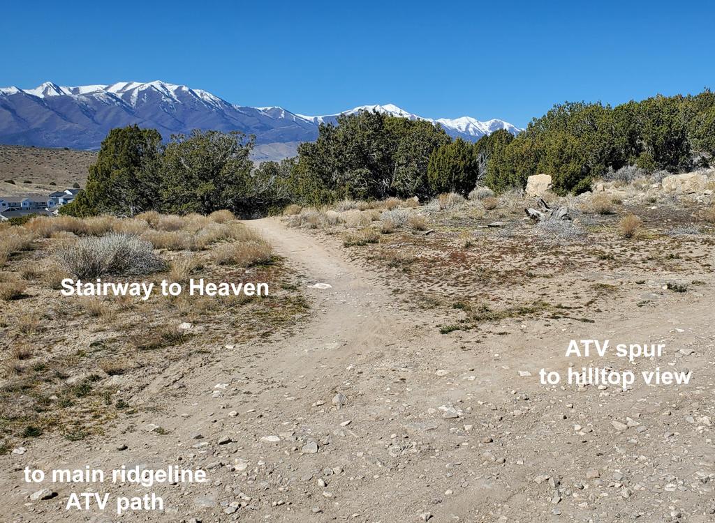
I-15 and Radio Free Europe - climb to the flow trails

Each lap will be between 0.8 and 1.0 miles with approximately 120 vertical feet of climbing per lap.
Now you'll reach a three-way trail split. To the right is the easiest and longest DH flow route, Huey & Louie. Straight ahead is Rick Roll, which is steeper and has a short bit of bumpy rock. To the right is the most difficult DH route, Erasure, which will split into Love2 and HateU about half-way down the hill.


As you head southbound on the top traverse of Radio Free Europe, you'll come to a three-way trail split. The option to the left is Huey & Louie, the easiest of the downhill flow options. This trail is 0.4 miles long and will descend just under 90 vertical feet.


HateU is the left fork at the end of the second rock garden. It's actually a very easy trail, adding a bit of distance at a mellower rate of descent. HateU is 0.3 miles long, making the full descent via this route 0.4 miles.
HateU joins Love2 just before the trails end on I-15, right at the entry into the Tears for Fears loop (see below).


Love2 is angles downhill for a fairly straight and fast return to the bottom of the loops. It's 0.1 miles long.
Love2 recombines with HateU and ends on I-15 at its origin on Creed. Immediately on your left are two trails. The uppermost one is the entry to the Tears for Fears beginner loop, and just downhill to the right of Tears for Fears is I-15. For another trip to the top, get on I-15.
As you descend Love2, you'll notice a set of wooden ramps to the left. You can veer off Love2 to hit the jump of your choice. There were 4 jump options when I rode through in March 2026.
About 50 feet after the jump, you'll wind up at HateU, where you should turn right to continue the descent. If you fly across HateU you'll wind up on the west side of the Tears for Fears loop about 20 feet downhill. Here you may encounter inexperienced slow riders and groups standing around. So turn right at the first trail.


The entry to Tears for Fears is right where I-15 forks away from Creed. Go to the left uphill from I-15, and you're on the stem of the loop. Keep left as the loop entry turns 90 degrees left to go straight up the hill. (The actual "loop" will start at the trail fork about 30 feet uphill. I think.)


Now you'll traverse east, climb through a long left-right-left uphill turn, then traverse west. Now the trail turns left downhill. Below you there are two little baby rock ledges, and the steepest bit of trail on the loop. (Not skid-your-tires steep; just enough to possibly make your little tyke stop their bike.) In 20 feet, you're back at the "bump" in the middle of the loop trail fork. Turn to the left to take another lap around the loop. Or go to the right of the dirt bump and straight downhill if you're exiting.

Tougher riders may find this trail cluster useful for a quick ride when time is limited.

Creed
Creed passes over the top of Hickman Hill, with a southern end just west of the Hickman Hill loops. It's 1.4 miles in length, spanning between the Given to Fly trail and the Pony Express Parkway. The trail climbs up and over a hill -- whichever direction you ride it. The climbing is around 250 vertical feet.
On the south, Creed begins at the southwestern entry to the Hickman Hill loops. Just keep to the left and pass the I-15 entry to Hickman as you pedal up from the valley, then immediately keep right at the Brass Monkey trail fork.
Creed can also be reached via a short connector from the top of Radio Free Europe, which is the climbing route for the Hickman Hill loops.

Brass Monkey
The Brass Monkey trail runs around Hickman Hill on the western side. It begins by forking away from the southern end of Creed, which shares an entry trail with the Hickman Hill loops. After riding around and over the flank of the hill, Brass Monkey connects to the bottom of Nirvana at the Pony Express Parkway.
Brass Monkey is 0.9 miles long and has around 100 feet of climbing when done in either direction. It requires intermediate riding skill and aerobics.

Given to Fly
Given to Fly begins in a shallow valley just west of the paved Hidden Hollow trailhead. It's two-directional, but you'll like it more as a downhill. As a climber, it's mellow and easy at first, then reaches a steep area with a couple of rock drops that will probably have you pushing your bike.
Length 1.4 miles. 350 vertical feet of altitude change. The steep spots make it an upper-intermediate trail, although most of the trail is quite easy.

Runs from Treadstone at the top of the Prayer Flags hill northbound to end at the Pony Express Parkway. Here there's a connector to the north end of Brass Monkey. Can be part of the northern end of a longer loop ride in either direction. NOTE! Nirvana has been interrupted by a fence in November 2022. There's a re-route, but the trail's status could change.
Length 2.0 miles. Vertical 300 ft elevation loss when done from south to north. Trail surface intermediate skill and aerobic requirement.
 trailhead.")
From the paved bike path along the Pony Express Parkway, there's a new paved trail extending uphill into Hidden Canyon. At this time (June 2022) it's only partially paved, but will provide a connection uphill to the Hickman Hill beginner trails as well as Creed, Brass Monkey, Supersonic, and Given to Fly.
For now, it ends on Hidden Valley Parkway just north of the trailhead.

Take the I-15 Lehi Main Street exit and turn west. Continue west on SR-73, crossing Redwood Road (11600 West). Continue westbound uphill. Just after climbing the hill, turn left at the stop light onto The Ranches Parkway. At Pony Express Parkway, turn right. The road will veer a bit south (left), then back west (right) as you get one mile from Ranches Parkway. After you pass a large hill on your left, just before Hidden Hollow Elementary, take the next left. In 0.2 miles turn left into the large parking area.