With links to specific riding area trail pages
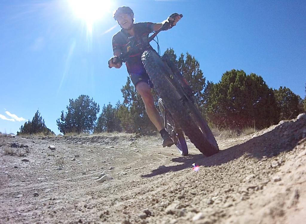
Eagle Mountain is a popular riding destination during late winter and early spring, because the trails are almost always ready to ride. In the summer you'll find mostly local riders hitting the trails early in the morning while it's still cool. There are a ton of trails here. This overview page has quick details on each trail, organized by riding area within Eagle Mountain.
- northern Eagle Mountain
trails
-Treadstone-area (Prayer
Flag hill) trails
- southern Eagle Mountain trails
- Lake Mountain slope trails
- Mountain Ranch Bike Park
- Eagle Mountain Race
Loop
- Jake the Snake

Runs from Treadstone at the top of the Prayer Flags hill northbound to end at the Pony Express Parkway. At the parkway there's a connector to the north end of Brass Monkey. Can be part of the northern end of a longer loop ride in either direction.
Length 2.0 miles. Vertical 300 ft elevation loss when done from south to north. Trail surface intermediate skill and aerobic requirement.

Runs from the southern end of Creed near the Given to Fly connector northbound to end at the Pony Express Parkway. In 2022, there's an arc of trail near the sidewalk that connects Brass Monkey to Nirvana. Can be part of the northern end of a longer loop ride in either direction.
Length 0.9 miles. Vertical approximately 100 ft when done in either direction. Surface intermediate skill, light aerobic requirement.

On the southern end, Creed starts by forking away from the Given to Fly and Hickman Hill connectors. It runs north to the Pony Express Parkway, crossing over the top of the hill. On the southern side, some stunts are built in for the downhill. (In 2022, construction has closed the far north end. Check conditions before planning to include Creed in your ride plan.)
Length 1.4 miles. Vertical approximately 250 ft done north to south, 200 if south to north. Surface requires upper-intermediate skills and moderate aerobic condition.

The Hickman Hill trails lie just east of the southern side of Creed, just uphill from the subdivision in Hidden Canyon. From the I-15 trail at the bottom, here's a one-way trail 0.6 miles long leading uphill (Radio Free Europe) with three downhill-only flow trails 0.4, 0.3, and 0.2 miles in length, named Huey & Louie, Rick Roll, and DH#3 name TBA.
Length 0.8 to 1.0 miles per lap. Vertical approximately 100 vertical ft per lap. Rated experienced-beginner in skill requirement, early-intermediate aerobic requirement.

The Hidden Canyon trail starts just off the paved trail at the Pony Express Parkway east of Hidden Canyon Elementary. It climbs the hill to the area above the Mountain Ranch bike park, connecting to Rock-a-Billy, Ridgeline/Cow Tracks, and Golden Eagle.
Length 0.7 miles, climbing 200 vertical feet when done from Hidden Canyon up to the bike park connector trails. Surface upper-intermediate technical, upper-intermediate in aerobic effort.

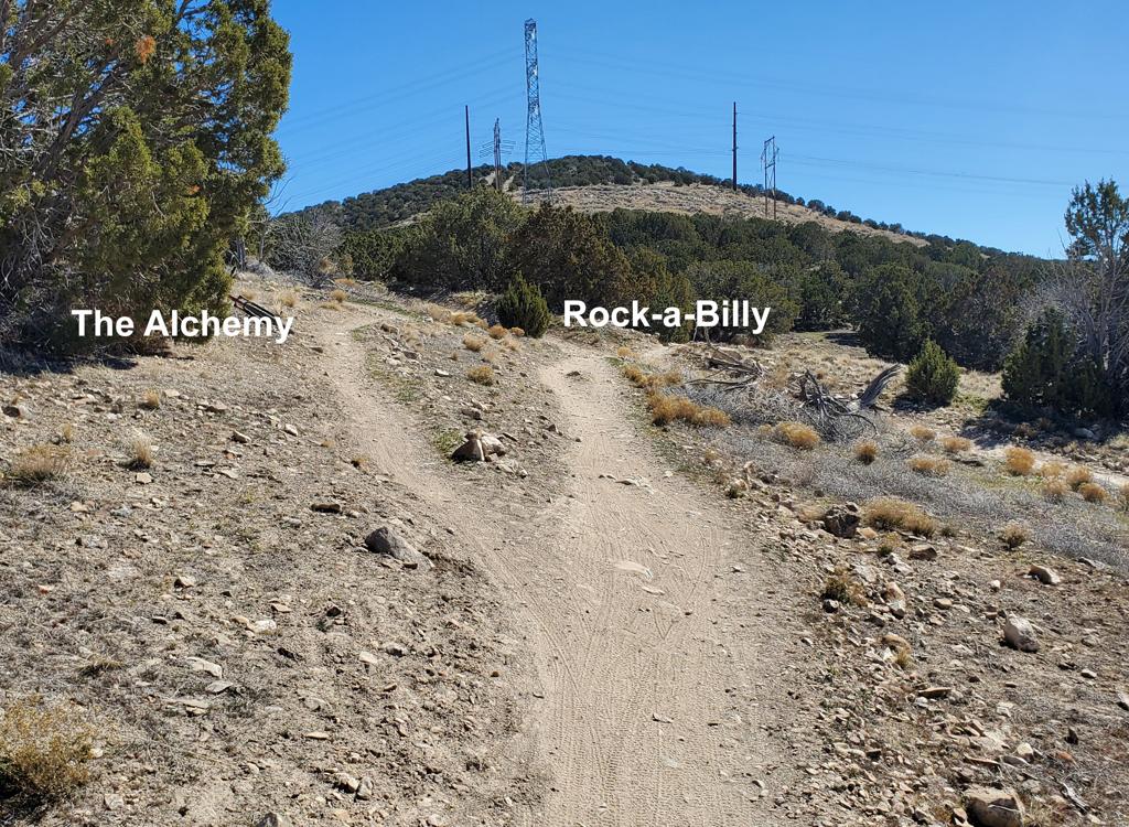
Rock-a-Billy forks to the south from Hidden Canyon, 0.2 miles uphill from the Pony Express Parkway. It rolls up and down, but generally climbs, as it traverses the western slope of Lake Mountain. The Rock-a-Billy trail ends on the Cow Tracks trail just above the "Rockpile" parking area. It can be accessed from the paved Hidden Hollow parking lot via a short connector trail.
Length 1.1 miles, climbing 200 vertical feet from Hidden Canyon to Cow Tracks (riding south). Surface intermediate technical, easy in aerobic requirement.

Cow Tracks links the trails at the top of the Mountain Ranch bike park to the "Rockpile" parking area in the middle of the Eagle Mountain trails. It contours the hillside before making a descent to the Rockpile. The trail has one steep pitch and there are some embedded rocks. Cow Tracks joins Rock-a-Billy as it descends to the east side of the Rockpile parking area.
Length 0.8 miles. Surface intermediate in technical requirement, one steep pitch of upper-intermediate aerobic effort. Around 50 feet of elevation change north to south.


northern Eagle Mountain trails
Best trailheads for these trails
paved trail from Pony Express Parkway
Hidden Canyon trailhead
"Rockpile" parking and connect via
Given to Fly or Nirvana
Runs from Treadstone at the top of the Prayer Flags hill northbound to end at the Pony Express Parkway. Here there's a connector to the north end of Brass Monkey. Can be part of the northern end of a longer loop ride in either direction.
Length 2.0 miles. Vertical 300 ft elevation loss when done from south to north. Trail surface intermediate skill and aerobic requirement.

Given to Fly is two-directional, but you'll like it more as a downhill. As a climber, it's mellow and easy at first, then reaches a plunge (which you're trying to pedal UP) with a couple of rock drops that will probably have you pushing your bike.
Length 1.4 miles with 350 vertical feet of climbing when done from the valley up to the top of the Prayer Flags hill. The steep spots on the higher elevations make Given to Fly an upper-intermediate trail, although most of the trail is quite easy.

Supersonic runs between Hidden Canyon and Treadstone at the top of the Prayer Flags hill as the continuation of Treadstone. It rides well in either direction and is a popular route for longer loop rides. (In June 2022, the trail has been interrupted at Hidden Canyon. Until it's restored, you can transfer to Cracker Jack for a shorter ride, or substitute Given to Fly if your loop includes the northern trails.)
Length 1.1 miles with 300 vertical feet of climbing when done from Hidden Canyon. Surface easier-intermediate, modest aerobic effort.

Cracker Jack forks away from the Deer Tracks trail just uphill from the "Rockpile" parking zone. It extends north to Hidden Canyon. In June 2022 the northern end has been interrupted by subdivision construction, requiring a transfer to Supersonic at mile 0.6 to continue your ride.
Length 0.7 miles with 150 vertical feet elevation loss from Deer Tracks to Hidden Canyon. Surface beginner, modest aerobic effort when done north to south.

(Treadstone Connector)
Treadstone can be reached quickly from the Race Loop 's trailhead (Rockpile) via Deer Tracks. The Deer Tracks trail starts westbound away from the dirt road just where you enter the parking area. In 100 feet, it forks to the left while Cracker Jack goes to the right. It climbs gently 0.2 miles to intercept Treadstone at the transition from the Billy Idol portion to the Cougar Tracks portion of Treadstone.
Length 0.2 miles, 50 feet of climbing from Rockpile parking to Treadstone.
Treadstone extends from the northern end of Deadwood up to the top of the Prayer Flags hill. It has been divided into three segments: "Billy Idol" from Deadwood to the Deer Tracks intersection; "Cougar Tracks" from Deer Tracks to a cutoff on the western side of the hill, and "Prayer Flags" which winds around past the flags at the top of the hill and descends to Supersonic. Nirvana forks away from Treadstone near the top of the hill. Treadstone is a must-ride for the Eagle Mountain experience!
Length 2.1 miles with 300 vertical feet of climbing when done from Deadwood to the hilltop at the Prayer Flags. Intermediate tech with moderate aerobic effort.

Backspacer begins on Given to Fly on a ridgeline and descends. It crosses Treadstone then continues down to the doubletrack and Cropduster in the valley before turning west to link to the northern end of Deadwood. The trail isn't particularly technical. This is an easy descent. There is one dip through the wash that beginning riders will want to walk. Near the bottom of Backspacer is a trail fork for Cropduster , a popular option.
Length 0.7 miles with 200 feet of descent when done from the Prayer Flags hill down to Cropduster in the valley. Easier-intermediate in tech requirement. Moderate aerobic effort when climbing.
Space dust begins and ends on the doubletrack between the "Rockpile" parking area and the northern end of Deadwood and western end of Treadstone. It has about 1/10th mile of doubletrack at the western side. It doesn't link to any other trails, but is a nice "on the way" option if you're heading from Deadwood back to the Rockpile parking and don't want to climb up Treadstone.
Length 0.6 miles with 50 feet of climbing and descending. Easy-intermediate in tech requirement, easy aerobic effort.

The downhill end of Cropduster forks away from Backspacer after southbound Backspacer crosses a dirt road. Veer to the left and turn east along the edge of the ravine. Cropduster will give you a gentle but sustained climb to the top of the ridge on Lake Mountain where you can connect to Gunslinger downhill.
Length 1.3 miles in length with 300 feet of elevation gain when done west to east. Very easy technical riding, gentle rate of climb.

Many riders use stretches of the ATV track to link their singletrack options together. From "the Rockpile" parking zone, there are doubletracks heading east uphill to Jackrabbit and a viewpoint, west to Space Dust and Deadwood, and south to Road Runner, Wile E Coyote, and 411 to Fistful of Dollars.


Treadstone (Prayer Flag) trail area
Best trailheads for these trails
ride from Pony Express Parkway via Rock-a-Billy
"Rockpile" parking and connect via Deer
Tracks
to Treadstone
Rock-a-Billy is the connection from the east side of lower Hidden Canyon to the "Rockpile" area. It begins on the Hidden Canyon trail and ends on Cow Tracks.
Length 1.1 miles with 200 feet of elevation gain north to south. Easier-intermediate in tech requirement, mile aerobic effort.

The Hidden Canyon trail starts just off the paved trail at the Pony Express Parkway north of Hidden Canyon Elementary. It climbs the hill to the area above the Mountain Ranch bike park, connecting to Rock-a-Billy, Ridgeline/Cow Tracks, and Golden Eagle.
Length 0.7 miles, climbing 200 vertical feet when done from Hidden Canyon up to the bike park connector trails. Surface upper-intermediate technical, upper-intermediate in aerobic effort.

Cow Tracks links the trails at the top of the Mountain Ranch bike park to the "Rockpile" parking area in the middle of the Eagle Mountain trails. It contours the hillside before making a descent to the Rockpile. The trail has one steep pitch and there are some embedded rocks. Cow Tracks joins Rock-a-Billy as it descends to the east side of the Rockpile parking area.
Length 0.8 miles. Surface intermediate in technical requirement, one steep pitch of upper-intermediate aerobic effort. Around 50 feet of elevation change north to south.

The Ridgeline Trail connects Cow Tracks to Hidden Canyon before heading northeast across the top of the bike park area and descending down to the Juniper trail in the bike park. The portion northeast of the loop is also known as the Golden Eagle trail and a portion of the loop is also known as Big Thunder.
Length 2.0 miles with 300 feet of elevation change from top of loop to lower bike park. Loop is 1.2 miles with 150 feet of climbing. Upper-intermediate in skill and aerobic requirement.

There's an ATV trail at the very top of the ridge going north-south. You can access this trail at several points: In the bike park, from Jackrabbit or nearby ATV routes, and at the southern end from Wile E Coyote or the valley doubletrack. It's a combination of the water-tank road, a bit of un-named DT, and the southern ridgeline end of OHV route 2. The top of Jackrabbit, Gunslinger, and Crop Duster can be reached via this doubletrack.
")
Bugs Bunny ties the rockpile parking area to the top of Jackrabbit (via Paintball City). When riding southbound, it's the continuation of Cow Tracks, and ends at the viewpoint where the doubletrack Paintball City begins. Bugs Bunny crosses to the eastern side of Lake Mountain, offering views you won't see on most Eagle Mountain trails.
Length 0.6 miles with around 200 feet of overall climbing when done north to south.

Jackrabbit starts high on the ridgeline at around the middle of the Eagle Mountain riding area. It begins at the end of Bugs Bunny. It can also be reached by doubletrack at the viewpoint 0.3 miles uphill from the Rockpile and 0.1 mile from the top of Roadrunner. The first portion is doubletrack and is called Paintball City. Jackrabbit is 1.4 miles long with almost no overall elevation change, but with a fair amount of up-and-down. There may be alternate lines as the singletrack winds through a juniper forest. Depending on how you ride, the northernmost portion of Jackrabbit may be doubletrack or singletrack nearby.
Length 1.4 miles with around 150 feet of overall climbing but no elevation change between beginning and end. Easier-intermediate in tech requirement and aerobic level.

From the Rockpile area, Road Runner can be reached by taking a doubletrack to either end. It can also be reached by climbing Bugs Bunny and turning onto Rocket Powered Roller Skates, which ends across the dirt road from Road Runner. Road Runner is 0.8 miles long, but with only about 60 feet of overall elevation gain. My description will assume you started the downhill southwestern end, as is done for the race loop. It branches away from OHV route 3 0.3 miles south of the "Rockpile" parking area. Wile E Coyote will fork to the right (southbound) just 1/10th mile uphill. Roadrunner ends on OHV route 2 just below the big valley overlook.
Length 0.8 miles, 60 feet of overall elevation gain.

Crop Duster is a two-way trail that functions as a climbing route to Gunslinger, or as a swooping easy downhill. Crop Duster begins on the Backspacer trail, heading east. It has connections to Gunslinger (top and bottom) and to Jackrabbit and Roadrunner.
Length 1.3 miles in length with 300 feet of elevation gain when done west to east. Very easy technical riding, gentle rate of climb

The top of Gunslinger is also the top of Crop Duster, on the ridgeline ATV track. While most riders use Gunslinger as a downhill, it's a two-way trail. So yield to climbers on your way down. Turns are banked and the riding is fairly easy. There are a few engineered jumps that intermediate riders can simply go around.
Length 0.5 miles with 200 feet of elevation loss east to west.

Wile E Coyote is a favorite north-south route on the eastern side of the big valley. It forks away from Roadrunner just 150 yards from Roadrunner's southern end on ATV route 3. From the origin on Roadrunner the trail runs south 0.9 miles before ending at a dirt-road fork just across from the southeastern end of Deadwood. This southern end of Wile E Coyote on ATV route 3 has connections to the south end of OHV route 2, the 411 trail (which starts on the doubletrack) and OHV route 4 to connect to the Deadwood trail.
Length 0.9 miles with 150 feet of elevation gain riding north to south.

southern Eagle Mountain trails
Best trailheads for these trails
Hidden Canyon to Rock-a-Billy from the
Pony Express
Parkway
(Hidden Canyon trailhead not finished)
"Rockpile" parking and connect east via
doubletrack
- southern trails continued on map below
Beggar's Canyon is a downhill run in a washbottom. It's found in the middle of the valley east of Deadwood and west of Jackrabbit. The top of the trail lies in a small wash, found on a doubletrack extending west from the bottom of Jackrabbit. It ends on Backspacer near the bottom of Deadwood.
Length 1.1 miles with 200 feet of elevation loss south to north.

Crop Duster is a two-way trail that functions as a climbing route to Gunslinger, or as a swooping easy downhill. Crop Duster begins on the Backspacer trail, heading east. This western end is fairly flat, following a wash across the valley. Crop Duster has connections to Gunslinger (top and bottom) and to Jackrabbit and Roadrunner.
Length 1.3 miles with 300 feet of elevation gain when done west to east. Very easy technical riding, gentle rate of climb
As a downhill, Gunslinger starts right where Cropduster ends. The trail drops to the west before turning back north to rejoin Cropduster 0.5 miles later. The vertical drop is 200 feet.
Length 0.5 miles with 200 feet of elevation loss east to west. Intermediate in tech requirement.

Jackrabbit starts high on the ridgeline at around the middle of the Eagle Mountain riding area, about 0.3 miles from the Rockpile and 0.1 mile from the top of Roadrunner. The first portion is doubletrack. Jackrabbit is 1.4 miles long with almost no overall elevation change, but with a fair amount of up-and-down.
Length 1.4 miles with around 150 feet of overall climbing but no elevation change between beginning and end. Easier-intermediate in tech requirement and aerobic level.

From the Rockpile area, Road Runner can be reached by taking a doubletrack to either end. Road Runner is 0.8 miles long, but with only about 60 feet of overall elevation gain. My description will assume you started the downhill southwestern end, as is done for the race loop. It branches away from OHV route 3 0.3 miles south of the "Rockpile" parking area. Wile E Coyote will fork to the right (southbound) just 1/10th mile uphill. Roadrunner ends on OHV route 2 just below the big valley overlook.
Length 0.8 miles, 60 feet of overall elevation gain.

Wile E Coyote is a favorite north-south route on the eastern side of the big valley. It forks away from Roadrunner just 150 yards from Roadrunner's southern end on ATV route 3. From the origin on Roadrunner the trail runs south 0.9 miles before ending at a dirt-road fork just across from the southeastern end of Deadwood. This southern end of Wile E Coyote on ATV route 3 has connections to the south end of OHV route 2, the 411 trail (which starts on the doubletrack) and OHV route 4 to connect to the Deadwood trail.
Length 0.9 miles with 150 feet of elevation gain riding north to south. Easier-intermediate riding.

411 is usually used as a climbing route to the top of Eastwood and Fistful of Dollars. It consists of around 1/10th mile of ATV track followed by a narrow singletrack winding up the mountain. At the top, it gives birth to your choice of Eastwood or Fistful of Dollars for the trip downhill.
Length 0.6 miles with 200 feet of elevation gain. Upper-intermediate in difficult.

Eastwood is a two-way trail that most riders use as a downhill. There is the option of climbing Eastwood to descend Fistful of Dollars, but the tire tracks indicate that almost nobody does this. It begins at the top of 411 straight across from Fistful of Dollars, heads back parallel to 411 then crosses over to descend the mountain. It crosses Deadwood before joining Fistful of Dollars near its end.
Length 0.8 miles with 230 feet of elevation loss when done south to north. Intermediate in tech requirement. Strenuous aerobic effort as a climb.

Fistful of Dollars is an expert-level downhill-only trail that starts at the top of 411 and Eastwood. While much of the trail is swooping singletrack, there are some short but slippery rock steeps that require aggressive attitude and good skills.
Length 0.6 miles with 230 feet of elevation loss. Expert skills required.

Deadwood is a fun trail on the western side of the big valley. Most riders will do it downhill south to north. The slope is gentle and it's easy to ride. In 2022, the track was widened and turns were banked for a zippy ride. It's part of the race loop and a must-do if you ride Eagle Mountain. Deadwood starts on ATV route 4 near the end of Wile E coyote and ends at the ATV route 1 across from the western end of Treadstone.
Length 1.9 miles with a bit of climbing on the southern end then 300 feet of elevation loss northbound.


northern Eagle Mountain trails
Best trailheads for these trails
"Rockpile" parking and connect via
the doubletrack ATV paths
The 110 trail is a skills jump line on the lowest elevation of the bike park. It's 0.4 miles long, done from south to north.
Length 0.4 miles, elevation loss 100 feet.

The 220 trail is a skills and jump-line route that begins at the base of the Juniper trail. Its jumps and stunts are higher voltage than those on the 110 trail.
Length 0.4 miles with elevation loss of 150 feet.

The Juniper trail is a loop on the north-facing hillside just above the jump lines of the bike park. It begins at the southwest corner of the park area, traverses the hillside, then descends to the northeast corner of the park. There are frequent ladders and other stunts and challenges.
Length 0.9 miles, 200 feet of climbing.

The Rockwell trail lies just above the Juniper trail on the slopes of the bike park. It offers more flow and faster challenges than the Juniper Trail as you head northeast and descend.
Length 0.4 miles, intermediate tech skills.

The Ridgeline trail runs parallel to Juniper and Rockwell, but higher on the hill. This bit of Ridgeline is also 0.4 miles long and is also called Golden Eagle. At the western end, there's a loop that contains a switchback section known as Big Thunder. The loop offers connections to Cow Tracks and Hidden Canyon.
Length 2.0 miles with 300 feet of elevation change from top of loop to lower bike park. Loop is 1.2 miles with 150 feet of climbing. Upper-intermediate in skill and aerobic requirement.
The Hidden Canyon trail starts just off the paved trail at the Pony Express Parkway east of Hidden Canyon Elementary. It climbs the hill to the area above the Mountain Ranch bike park, connecting to Rock-a-Billy, Ridgeline/Cow Tracks, and Golden Eagle.
Length 0.7 miles, climbing 200 vertical feet when done from Hidden Canyon up to the bike park connector trails. Surface upper-intermediate technical, upper-intermediate in aerobic effort.
Cow Tracks links the trails at the top of the Mountain Ranch bike park to the "Rockpile" parking area in the middle of the Eagle Mountain trails. It contours the hillside before making a descent to the Rockpile. The trail has one steep pitch and there are some embedded rocks. Cow Tracks joins Rock-a-Billy as it descends to the east side of the Rockpile parking area.
Length 0.8 miles. Surface intermediate in technical requirement, one steep pitch of upper-intermediate aerobic effort. Around 50 feet of elevation change north to south.

Best trailhead:
Take the I-15 Lehi Main Street exit and turn west. Continue west on SR-73, crossing Redwood Road (11600 West). Just after climbing the hill, turn left at the stop light onto The Ranches Parkway. Stay on that road as it narrows and begins to wind around. When you come to a T intersection at the end of The Ranches Parkway, turn right on Golden Eagle Road. Drive about 1/3 mile and watch for the trail kiosk on your left. Park by the trail kiosk and begin your ride by climbing up the trail heading south.
Alternate: Ride to the bike park via Hidden Canyon or Cow Tracks from the main Eagle Mountain riding area
The Jake the Snake trail starts just off the Pony Express Parkway behind the church. After climbing the hill, it has an out-and-back spur to the top of the hill. The trail then descends back to the Pony Express Parkway right across the street from the Hidden Canyon trail's beginning.
Length 3.0 miles one-way with the out-and-back, climbing 375 feet. Jake the Snake trail page

The Golden Eagle Bypass trail runs across a knoll just east of the Mountain Ranch bike park from Golden Eagle Road. Primarily of interest to locals. Doesn't connect to other area trails. Length 0.8 miles with around 200 feet of climbing.
This is a downhill-only expert trail with some high-expert options. It starts on the east ridgeline above the DH trails and descends to dirt road in southern Eagle Mountain. Most riders do this with a shuttle vehicle. The top of the trail is up a DT from the middle of Jackrabbit or Roadrunner. Flintstone page


Lots of great riding in this area, good for experienced beginners but satisfying for experts and hammerheads. Conditions allow riding almost all year, even when everything else is closed.
-
northern Eagle Mountain
trails
-
Treadstone-area (Prayer
Flag hill) trails
-
southern Eagle Mountain trails
-
Lake Mountain slope trails
-
Mountain Ranch Bike Park
-
Eagle Mountain Race
Loop
-
Jake the Snake
Creed: At 0.25 miles past the elementary school, spot the trail on the hillside to your left and cross the decorative patch of chunk rock to get there. (Note construction has blocked this access in 2022!)
Race Loop (rockpile) Parking:Note 2022! While construction crews are trying to preserve access, it is occasionally not possible to drive through construction area! If so, you must ride from the Pony Express Parkway, or take the dirt road (OHV route 1) in from the west. On Pony Express Parkway, turn south and drive uphill past Hidden Hollow Elementary. When the pavement ends, keep as straight as possible southbound through the construction area. Drive a mile up the dirt road. After you reach the top of a small rise and see another valley in front of you, there's a big rockpile on the left. The parking is the primitive open space south of the rockpile. Deer Tracks is west of the parking area (across the dirt road), Cow Tracks is at the northeast corner, and dirt roads on the east and south connect to other singletrack trails.
Mountain Ranch Bike Park:
Take the I-15 Lehi Main Street
exit and turn west. Continue west on SR-73, crossing Redwood Road (11600
West). Just after climbing the hill, turn left at the stop light onto The
Ranches Parkway. Stay on that road as it narrows and begins to wind
around. When you come to a T intersection at the end of The Ranches
Parkway, turn right on Golden Eagle Road. Drive about 1/3 mile and watch
for the trail kiosk on your left. Park by the trail kiosk and begin your
ride by climbing up the trail heading south.
Bathrooms: None. Porta-Potty at the Mountain Ranch
Bike Park. A
full-service trailhead is planned for Hidden Canyon.
Camping: No developed or designated campgrounds. Flat spots can be
found in the race
staging area near the rockpile.
Bike services: UtahMountainBiking store in Lehi.
GPS track files and route (right-click and "Save as..."):
Multi-track GPX area file
High-res area topo map for printing: View topo
Lodging, camping, shops: Links to Provo area resources