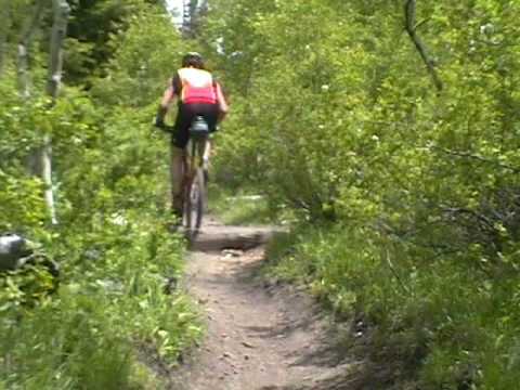
View north from the first section of the South Fork trail. Beginning elevation is 6900 feet. Original review and photos October 2, 1999 by Bruce. Latest update August 18, 2018.
Deer Creek South Fork LoopThis classic 6.6-mile singletrack loop is great fun, and not too
tricky. Like the
Timpooneke
Loop
and the
Tibble Fork Loop
, this trail uses a portion of
Ridge Trail 157
as its middle section.
There's about 1200 vertical feet of elevation gain for the entire loop.
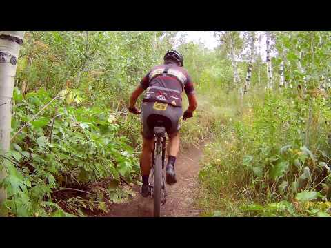
Some South Fork portions of
the trail are narrow with elevated sidewalls, requiring good bike
handling. The Ridge Trail portion is wide and well-traveled, but is the
toughest part of the ride..
There are two trailheads for the loop itself: the Alpine Loop summit trailhead and Elk Glen
(a primitive camp that connects to the loop via a short spur).
Many riders make the loop a lariat by starting from trailheads at
Timpooneke
,
Salamander Flat, or
Pine Hollow
, then pedaling
uphill to the loop.

View of the trail as it skirts a meadow on the way to the Alpine Loop summit. Some spots have sunken narrow trail, requiring good handlebar action to keep on track. October 2, 1999

Heading uphill from Elk Glen.
Many riders begin the ride from Elk Glen on the Cascade Springs Road in the North Fork of Provo
Canyon. That way, you complete 1.75 miles of steady uphill right away.
Beginning from the Elk
Glen (aka Elk Camp) parking area on the south side of the road, ride uphill
1/4 mile and join
the DCSF trail. Keep straight and uphill. The narrow singletrack trail
climbs gently, passing
through meadows between aspen and pine.
Deer Creek South Fork uphill
Watch for deer and moose, especially in early morning or late evening. As you climb uphill
from Elk Glen, you'll pass through three meadows.
This area tends to be relatively more wet than other trails in American Fork Canyon. If you
encounter mud, turn around and find somewhere else to ride.

Much of the climb is smooth ribbon winding through the aspens.

Almost to the top. The moisture and rich soil in this area results in tall ferns and huge berry bushes.
When you reach a gravel road, look for the continuing trail straight ahead. You'll come out
on the Alpine Loop paved road, right at the intersection with the Cascade
Springs road. Straight
ahead across the road is the continuation of the Deer Creek South Fork
trail.
Climb up to a trail fork and turn right. (To the left is the
Lame
Horse
trail. It descends to Aspen Grove.) 1/10th mile later, you'll
arrive at the Alpine Loop summit parking area.
Ridge 157 Trail
Veer to the right in the paved circle at the trailhead. Take the trail near the entry road,
on your right, marked by an official trail sign. Pedal 60 feet, then cross
the Alpine Loop
road to the Ridge 157 trail.
On the Ridge trail, you'll reach the ride's highest elevation of 8100 feet.

Portions of the Ridge trail are bumpy.

Bruce rolls up to the classic viewpoint on the Ridge trail. This comes just before you descend down to Mud Springs.
The ridgeline is the remains of a col, a fin left standing between an eastward-flowing and
a westward-flowing glacier. Glaciers, dating from the last Ice Age, are
responsible for many
of the flat-bottom, rounded valleys in the higher Wasatch.
The first trail fork on the Ridge trail comes in about a mile. To your left is the Ridge Connector.
Keep right to stay on the Ridge. At mile 1.3, keep right again as the
Pine Hollow trail joins
on the left.
Take in the views, and note the difference in the mountains north and south. The American Fork
Canyon area falls on the edge of a massive igneous rock intrusion, where
the sedimentary limestone
(Oquirrh formation from the Pennsylvannian Era -- 300 million years ago
-- as seen on Mt. Timpanogos)
gives way to granite in the Lone Peak-Little Cottonwood area.

There are several spots where you can get a good look at the mountains.

Heading up the last of many climbs on the Ridge trail. Almost there.
At mile 2.2, turn right uphill at the fork with Mud Springs. A short bit of tough climbing
here.
Three miles from the summit trailhead, you'll reach a 4-way trail intersection. (The Ridge
trail continues straight; Tibble Fork is on your left.) Go right downhill.
Deer Creek South Fork downhill
The trail now begins a steady descent into the South Fork of Deer Creek. At first, it's the
usual aspens, with a smattering of oak and maple.

Rounding the first turn below the ridge.

Flowing trail through fir forest.
After the first turn, the trail drops into a forest of tall evergreens. There are a few root
drops, nothing more than 10-12 inches. This section of the trail is pretty
buff.
After a short climb, the trail re-enters forest of oak, maple and aspen as it curves around
to the sunny side of the hill.
When the trail reaches the Cascade Springs road, cross to the continuing trail. In around a
tenth of a mile, you'll hit the spur to Elk Glen. If that's where you
started, make a hard
left downhill to return to your car.

Almost at the end of the deep forest. A quick little uphill, then more descending down to the Cascade Springs road.

View over the aspens and spruces towards Mount Timpanogos. The Mad Scientist's bike "Banana Thunder" sits among bitterbrush in the foreground. October 2, 1999
Portions of the trail are usually snowbound until mid June. Snow usually covers the trail again
in late October, but even then, hard-core riders can be found thrashing
the snow on the Ridge.
Late September is an excellent time to ride this trail, as the fall colors
change.
Bottom Line!
This is one of the greatest little loop trails anywhere. Since discovering Deer Creek South
Fork we can't get enough of it. And, lucky you, we're sharing our secret.

Bruce posts a turn on the Ridge Trail near the descent into Deer Creek South Fork on June 30, 1999. Photo by Dominic Bria.

map of the DCSF area
Getting there: (Cascade Springs Road trailhead) From
I-15, take the Alpine-Highland exit just south of Point-of-the-Mountain. Go east towards
the mountains on UT-92 and continue up American Fork Canyon. There's a $6
fee (as of 2009). About 6
miles up the canyon, turn right at the North Fork junction. Drive up to the summit of the
Alpine Loop. (The summit trailhead is on your right just before you reach the
top of the loop.) For the lower trailhead, drive further to the
Cascade Springs Road, where you'll turn left. About 1.5 miles later, turn right on a
gravel road and go 100 feet. The trailhead is in the trees straight ahead. GPS N 40° 26.801' W 111° 36.489.
Camping:
multiple improved and primitive campsites in AF Canyon
Bathroom: Summit trailhead
Water: developed campgrounds