View south from the trail, looking over a couple of beaver ponds. Photos and trail checkout ride August 19, 2009 by Bruce and Jackie.
Co-op Creek Trail
with optional loop through Sleepy HollowThe Co-op Creek Trail is a very nice singletrack trail in the hills north of Strawberry Reservoir.
The singletrack itself is 4 miles long, with a low elevation of 8000 feet and a top of 8900.
The trail follows Co-op Creek up a canyon (in the upper 2 miles, the creek isn't visible through
the trees around the trail).
Most riders will want to do this trail as an out-and-back. If you drive down the doubletrack
from the Co-op Creek Road to park at the start of the singletrack trail (see below), the round
trip is 8 miles with 900 vertical feet of climbing. The rate of climb is reasonable and it's
easy technically, suitable for early-intermediate riders.
For stronger riders with loose-surface skills, I also describe a loop
ride of 12.5 miles that climbs to almost 10,000 feet elevation, with
spectacular views extending 40 miles. This route adds 1.5 miles on the
Co-op Creek Road, 3.3 miles on ATV track, and 3.2 miles descending the
singletrack
Sleepy Hollow Trail.

Early in the ride, we're descending from the trailhead toward Co-op Creek. Jackie's looking forward to the adventure.

Looking down and southwest at the willows and beaver ponds.
The ride begins with a gentle descent to the edge of the creek. Then we begin climbing. The
route follows an old dirt-road cut, so the trail is straight and the pitch
is steady. Along
the creek, there will be multiple springs and seeps -- so you'll get your
tires wet -- but
no bogging-down mud. The rate of climb here is gentle.
About a mile and a half uphill, the trail turns and crosses a small branch of the creek, then
begins climbing up the mountainside away from the creek. For a mile the
rate of climb increases
to an average of just under 500 vertical per mile. Not tough, but drop
into granny if you must.
There's only one fork on the trail, about 2.6 miles from the ST trailhead.
Keep straight. The
trail that forks sharply left downhill appears well used, but it's not
where you want to go.
(It meanders down, then up and around the mountain to the west, joining
a dirt road that goes
to Willow Creek.)
At the top, you can turn around for a great downhill cruise, or fork right on the doubletrack
to do the big loop ride. The loop involves another 1100 feet of climbing
on ATV track.

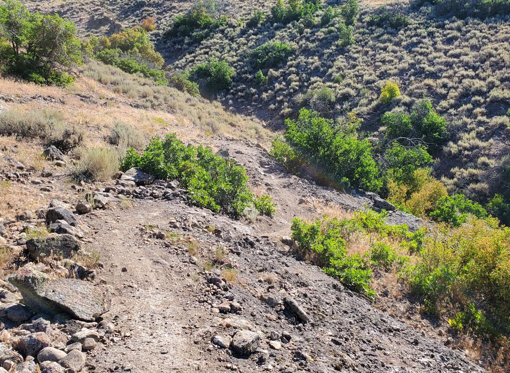
Typical view up the canyon. The trail sits on a shelf excavated by an old road.

Beaver pond with a dam about 8 feet in height.
If you're doing the loop ride, exit the singletrack and go L on DT. In 100 yards, you'll hit
the big gravel Co-op Creek Road. Turn R and crank 1.3 miles gradually
uphill. Then turn hard
left uphill on a rough-looking ATV road (it gets better).
The ATV road switchbacks up the hill at 500 vertical in the first mile. The surface was a little
loose and rocky, as most ATV routes are, but I didn't hate it. I never
lost traction and it
was actually a pretty easy climb considering the altitude. Once you exit
the forest, there
are incredible views. Above the plateau in the distance you can see Timpanogos,
Lone Peak,
Box Elder, and even Nebo. The ATV route will traverse southward around
Sleepy Hollow, just
downhill from the top of the ridge. You'll pass two ATV tracks forking
left uphill. The second
one heads to the top of Racetrack Peak, if you're interested in a higher
(10,400) viewpoint.
As the track crests a small rise, you'll see a vast expanse of downhill ahead of you. To the
right are the picturesque Red Ledge cliffs. Keep left here, ignoring smaller
tracks on the
right that go to primitive camping spots. Stop and take in the view.
(To see what things look like on this side of the loop ride, see the
Sleepy Hollow
trail page.)

View of the Co-op Creek Trail surface along the creek. Multiple seeps create wet spots.

Typical Co-op Creek Trail view further up on the mountain. The trail is very straight, climbing steadily uphill through aspen forest.
The doubletrack now descends at a 10% slope. Not tricky, but the surface will be loose from
ATVs gunning it uphill -- scary for riders who haven't learned how to
control the bike in loose
stuff. Keep left at any forks. About 3/4 mile down, the ATV trail turns
sharply to the left.
This is where the Sleepy Hollow Trail starts -- go straight ahead instead
of turning with the
doubletrack. This is a Critical Fork! As of August 2009, it was unmarked.
The enforcement officer
of the Forest Service tells me she plans to recommend a log barricade
and trail signs here
(to keep illegal ATVs out), so it may be well-marked by the time you ride.
If you miss the
singletrack, the ATV route will take you all the way to the bottom of
Co-op Creek Road at US-40.
Once you're on the Sleepy Hollow Trail, just keep heading generally downhill. The trail winds
around and back to the north, turning west in Sleepy Hollow itself. The
trail hits the road
at the log fence described in "Getting there" below.

Another view of Co-op Creek Canyon looking north.
Riding notes, out-and-back, ST only:
From Sleepy Hollow Trailhead N40 17.402 W111 09.865
Drive your car downhill on the DT heading west
At 0.7 miles, park at the turn-around
0.0 Enter ST straight ahead at turnaround
N40 17.554 W111 10.332
Descend gently toward creek
1.5 Trail climbs over small rise, cross branch of creek
N40 18.768 W111 09.934
Begin climbing west uphill away from
creek
2.6 Keep straight (hard L downhill = to Willow Creek)
N40 19.282 W111 09.452
4.0 Upper trailhead along DT N40 19.928 W111 08.792
(R= to Willow Springs, L = 0.1 to
main road)
8.0 Back at parking
Riding notes, loop with return via Sleepy
Hollow:
0.0 From Sleepy Hollow Trailhead N40 17.402 W111 09.865
Cross road and descend west on DT
0.7 Enter ST straight ahead at turnaround
N40 17.554 W111 10.332
Descend gently toward creek
2.2 Trail climbs over small rise, cross branch of creek
N40 18.768 W111 09.934
Begin climbing west uphill away from
creek
3.3 Keep straight (hard L downhill = to Willow Creek)
N40 19.282 W111 09.452
4.7 Upper trailhead, turn R on DT N40 19.928 W111 08.792
For out-and-back, turn around here.
For loop: R on Co-op Creek Road N40
19.901 W111 08.770
6.0 Hard L uphill on DT (Chicken Creek ATV route)
N40 19.119 W111 09.105
7.9 Keep R (ATV track on L heads up over ridge)
N40 18.706 W111 08.228
8.4 Keep straight (L = climbs to top of Racetrack Peak)
N40 18.366 W111 07.906
8.5 Highest point of ride, Red Ledge on L, views on R
Ignore smaller tracks forking
L
8.7 Keep R and southwest N40 18.183 W111 08.085
9.3 Critical Fork! As ATV track turns L, keep straight
N40 17.827 W111 08.465 - begin
Sleepy Hollow ST trail
10.0 Faint fork in draw. Go L and downhill. N40 18.401 W111 08.944
12.5 Back at trailhead
Trail conditions note, August 2009: The weekend before my ride, a severe storm hit the area.
At least 12 full-grown live aspen trees were blown down across the trail,
mostly on the upper
two miles. I informed the Forest Service, but it may take a while for
them to get there with
the chain saws. So expect to pick your bike up a few times.

area map
Getting there: Take US-40
southbound from Heber and drive up Daniel's Canyon 17 miles from the US-40
to US-189 junction. After passing the summit, continue another 5.5 miles,
passing the Strawberry Administrative area and paved road on your right. 7
miles past the summit, 1.5 miles from the road fork, turn left on the
Co-op Creek Road. N40 14.639 W111 09.419. (Stop at the outhouse in the
parking area if you need to.) Drive 3.4 miles up the Co-op Creek Road. As
the road turns sharply left and uphill (about 150 feet before a metal
gate), note a parking area on your right with a log fence at the end, N40 17.402 W111 09.865.
The log fence is the trailhead for the Sleepy Hollow Trail. The Co-op
Creek Trail starts as a doubletrack across the road.
The Co-op Creek Road above the trailhead is closed Nov 1
until July 1.