

The Cassidy Trail is a little-known but awesome ride. The trail starts on Highway 12 in Red Canyon. It connects to the Casto Canyon and Losee Canyon trails. Because the Cassidy trail is often combined with Losee Canyon, the Losee trail will also be discussed on this trail page.


The most popular ride is the 14-mile combination of the lower Red Canyon paved trail, Cassidy up to the top of Losee Canyon, Losee Canyon trail downhill, and two miles on the gravel Casto Canyon road.


From US-89, drive 4.2 miles east on U-12 (towards Bryce Canyon National Park). Pass the Thunder Mountain trailhead, the Visitor's Center, and a campground. Watch for a turnoff into a well-hidden parking area on the left, signed "Red Canyon Trailhead." The Cassidy Trail begins at the northeast corner of the parking area.

From US-89 south of Panguitch, drive 2.9 miles east on U-12 (towards Bryce Canyon National Park). Turn left on the gravel road marked for Casto and Losee Canyon. Drive 2 miles. Turn to the right into the Losee trailhead. Begin the ride on the Losee singletrack next to the kiosk. It's 3.1 miles uphill to reach the northern end of Cassidy.

Drive east from US-89 on U-12 (about 3 miles) until you reach the Thunder Mountain parking area on your right, just before the "Red Canyon" sign. This is a paved parking lot. Ride 1.7 miles up the paved trail, then connect across Highway 12 to the Red Canyon trailhead and start uphill on the Cassidy trail.

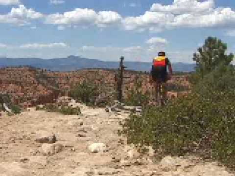
The Cassidy Trail climbs from a small trailhead on Highway 12 to an overlook above Losee Canyon, then descends into the head of the canyon. There are some optional meanders on the Rich Trail that make the mileage variable, but my route was 4.1 miles with 700 vertical feet of climbing.
The ride's highest point comes around mile 2.5, but there's some up-and-down once you're at the top.


The scenery is colorful limestone with a sprinkling of manzanita, cedar, long-leaf pine, pinion, and bristlecone pine. Temperatures are warm but tolerable at mid-day in summer.


0.0 Trailhead on U-12, N on ST
N 37° 44.111' W 112° 18.089'
0.9 Fork R (L = Rich Trail)
N 37° 45.320' W 112° 17.890'
2.3 Rich Trail rejoins
2.4 Fork L (R = Rich Trail)
N 37° 45.775' W 112° 18.349'
2.8 View, Braxton Point N 37° 46.062' W 112° 18.352' Alt=7860
3.2 Trails rejoin and split, veer R (L = Rich)
N 37° 45.944' W 112° 17.963'
5.2 Begin steep descent
5.7 Bottom of canyon, L to Losee
(R = Cassidy continues to Casto)
N 37° 46.638' W 112° 17.292'
9.1 Losee Canyon trailhead, L on gravel road
N 37° 46.183' W 112° 20.054'
11 L up paved road
12 Transfer to paved bike trail along road
14.1 Watch for trailhead (hard to see across road)

From US-89, drive 4.2 miles east on U-12 (towards Bryce Canyon National Park). Pass the Thunder Mountain trailhead, the Visitor's Center, and a campground. Watch for a turnoff into a well-hidden parking area on the left, signed "Red Canyon Trailhead." The Cassidy Trail begins at the northeast corner of the parking area. N 37° 44.111' W 112° 18.089'
One-page guide to this trail
Medium-res topo: View
High-res topo includes Casto (700 KB): View
Lodging, camping, shops: Links to Red Canyon area resources


