Looking toward the tailings from the Galena Trail. Review by Bruce on September 3, 2023 -- last updated May 16, 2025
Butterfield Park TrailsThe Butterfield Trailhead Regional Park opened in 2023 as part of the
Southwest Canyons Trail Network of Salt Lake County. (Rose Canyon and
Yellow Fork are also included in this network.) New trail was added in 2024 and 2025. There's around 16 miles of
new trail at Butterfield Park.
The trails lie south of the Butterfield Canyon Road at the mouth of the canyon. Starting elevation is 5400 feet, with a high of around 6400 at the saddle between Butterfield and Yellow Fork on the
Butterknife trail (which is a new section of the Bonneville Shoreline Trail). The expected riding season will be May through mid-November.

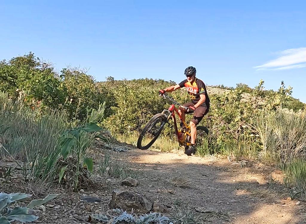
Looking northwest over the Salt Lake valley from the viewpoint on Goat Nose.

Eastbound on Copper Rise.
The trails are mostly on a north-facing slope. The terrain is a mix of gambel oak, cedar, juniper, maple and a rare stand of aspen. The system is machine-cut, highly engineered, and is mostly smooth easy riding. Turns are highly banked. There are occasional optional bumps that can be used as short jumps, but overall, the park is intended for beginner to early-intermediate riders.
Trailhead and Connections

Butterfield Park trailhead.
Butterfield Park trailhead
The trailhead is on the Herriman
Highway (13100 South) just east of the entry to the Butterfield Canyon
Road. The trailhead is large with room for over 100 vehicles, with curb
indicating spots for future expansion. There are dedicated handicapped
parking spots at the top near the kiosk. At the time of my 2024 update,
porta-potties are provided. The access trail is at the uphill (south) side
of parking, leading you to Galena, then Lucky Boy and the Juniper
connector.

On the Butterknife BST in Yellow Fork.
From Yellow Fork
You can reach the trail system from the south via the Rose Canyon trail system. At the picnic area 1.5 miles up Yellow Fork Creek, you can fork hard right onto the Butterknife section of the BST and ride 3.9 miles to the top of Outa Gas. There are no trail connections from the north.

Heading west from the access trail on Galena Gulch.
The Galena Gulch trail is your access to the northern side of the trail system. It's 1.1 miles long, extending from the bottom of the Juniper trail to the base of the Copper Rise Loop. Galena Gulch is suitable for beginning riders. There's 200 vertical feet of climbing on Galena Gulch as you ride east to west. You'll drop around 50 as you descend from the old lake shoulder down to the Copper Rise intersection.
Most trail users will enter Galena Gulch the
parking lot access path. 100 feet from the trailhead, Galena Gulch
actually goes both directions. To the right, you're headed for Millie,
then Copper Rise in 0.8 miles. To the left, Galena Gulch passes the bottom
of Lucky Boy before ending on Juniper after 0.3 miles.

Galena Gulch curves around a drainage, looking south.

Descending from the Millie trail fork and heading for the Bingham trail fork.
When heading west uphill on Galena Gulch, you can fork onto Millie or Bingham, both of which will rejoin Galena Gulch at the fork for Copper Rise.
Much of Galena Gulch is sage and oak, providing good views of the copper tailings on the northern side of the canyon. While descending the north-facing slope, you'll be in tall maple forest.

View east in tall maple.

Straight ahead (right) is Galena Gulch. We'll keep left to ride Millie along the shoulder of the hill.
Millie is an alternate path to the western half of Galena Gulch, lying higher on the mountain. It's a slightly easier ride for beginning riders. It's 0.8 miles long, beginning and ending on the Galena Gulch trail.
Millie forks to the left from Galena Gulch at mile 0.3 from the trailhead access path. After 0.4 miles on Millie, The Drop forks away to the right. (The Drop goes down to rejoin Galena Gulch near the trail fork with Bingham.)
At 0.8 miles from its origin on Galena Gulch, Millie ends at the junction between Galena Gulch and the Copper Rise loop. This can be a confusing intersection for first-timers. On the downhill side are Bingham and Galena Gulch. Uphill is the fork for the two sides of Copper Rise.

Arriving at the end of Millie on Galena Gulch. To the right (out of the picture) Bingham has joined. Ahead is the beginning and the return from Copper Rise.

The Pipe trail forks away to the right as we ride Millie westbound.
"The Pipe" is a 0.2-mile trail that descends from Millie down to the Galena trail. It joins Galena from uphill at the spot where Galena crosses an access road (just uphill from where the eastern end of Bingham joins Galena).

Bingham forks to the right from Galena Gulch as we cross an access road.
When headed west on Galena Gulch, the Bingham trail forks to the right just after The Drop joins on the left and Galena Gulch crosses an access road. It will rejoin Galena Gulch just before the Copper Rise loop trail fork.
This first section of the Bingham trail is 0.5 miles long, running parallel to the creek. There are a couple of trail forks where social trails cross the creek to alternate parking along Butterfield Canyon road. Keep straight.
In 2025, the western side of what was formerly Copper Rise has been renamed as part of the Bingham trail. The entire Bingham trail is 1.9 miles long, and is now considered a segment of the Bonneville Shoreline Trail (BST).

Typical trail scene on Bingham as we ride just above the creek.
Bingham Part Two, formerly western Copper Rise

Just a guy and his dog heading up Bingham for a counterclockwise ride on Copper Rise. Note that his dog is controlled with a leash!
The Copper Rise loop is a popular destination on the
northern side of the Butterfield Park trail system. The loop is 2.4 miles
around, with 300 vertical feet of climbing over the course of the loop.
Bingham is the climbing route. Continue west from eastern Bingham at
the trail fork with Galena Gulch and Copper Rise.
At the bottom, western Bingham and the Copper Rise loop are reached via Galena Gulch,
Millie, or Bingham (these three trails rejoin at, or just before, the Copper
Rise fork).
On the way up (riding counterclockwise), you'll briefly cross the creek
to a small parking area. This three-car space is used by hikers and will
usually be occupied on weekends.

Cranking uphill along the creek.

A rare stand of aspen as we climb higher on Copper Rise.
When riding Copper Rise counterclockwise via Bingham, you'll reach a 4-way trail
intersection at the top of the loop. Copper Rise continues straight on
doubletrack. To the right is Outta Gas (designated as part of the BST), which climbs to the top of the
Ridgeline trail and to Butterknife (Bonneville Shoreline Trail).
To the left is the 0.3-mile Goat Nose loop, which takes you to a
viewpoint then returns to Copper Rise just 0.1 miles from where you're
standing.
The descending side of a counterclockwise loop on Copper Rise is 350
vertical over 0.9 miles.
When descending from the top of the hill, you
can reach Copper Rise at its highest point by descending Outta Gas.

Approaching a banked turn while descending Copper Rise. Looking north.

Heading north on Goat Nose.
The Goat Nose loop starts on Copper Rise, makes a quick loop to a viewpoint over the copper tailings, then returns to Copper Rise about 100 yards from where it started. It's a two-way trail, 0.3 miles long with almost no elevation change.
At the westernmost corner of the loop, a 100-yard trail forks to the north, taking you to a viewpoint. This is a popular "we were there" photo op.

On the short spur to the viewpoint.

At the 4-way trail fork at the top of Copper Rise, looking south to Outta Gas.
Outta Gas extends from the highest point of the Copper Rise loop to a dirt and gravel access road on the ridgeline. Just before the road, the Ridgeline singletrack forks away to your left. As you cross the broad cindered area at the top of the doubletrack, you'll enter the Butterknife trail to Yellow Fork.
Outta Gas is 0.7 miles long, with a bit over 150 feet of elevation gain from Copper Rise to Butterknife.

Heading west on Outta Gas as we climb.
Butterknife Trail (Bonneville Shoreline)

Beginning the ride from Butterfield to Yellow Fork on the BST.
The Butterknife trail begins on the ridgeline at the top of the access road (Ridgeline doubletrack), as the continuation of the Outta Gas trail. The Butterknife section of the Bonneville Shoreline (BST) is 3.9 miles long. It ends where the Yellow Fork trail crosses the doubletrack (and there are a couple of picnic tables) around 1.5 miles up the canyon.
The trail begins at 6000 feet elevation. It will roll up and down, reaching a top elevation of 6400 feet on the ridgeline above Yellow Fork (2.9 miles from Outta Gas; 1 mile above the Yellow Fork trail). It descends 300 vertical feet into Yellow Fork.

Switchback turn near the ridgeline above Yellow Fork.

View south from the ridgeline above Yellow Fork.
An out-and-back ride to Yellow Fork from the Butterfield system will add 7.8 miles and around 1000 vertical feet of climbing to your ride.
The Butterknife section of the BST is discussed in detail on a separate page. See
Butterknife trail.

Entry to the singletrack option of Ridgeline, on the left. The doubletrack is a bit further uphill on Outta Gas -- at the sign.
Ridgeline seems to be a work in progress. Basically it's a rough dirt road from the top of the ridge down to the Juniper-Lucky Boy junction. The upper 0.2 miles has a hand-cut singletrack that you can use as an alternate. Overall the route is around 0.5 miles.
Most riders will want to ride the singletrack from the summit, join the doubletrack for a short distance when the singletrack ends, then divert left onto Sorta Shady to continue the descent.

Doubletrack section of Ridgeline, which is basically an access road.

Dropping toward the valley on Sorta Shady.
Sorta Shady is a singletrack joining the top of Juniper to the middle of the Ridgeline doubletrack. It's 0.7 miles long, with 150 feet of elevation change from west to east.
Sorta Shady is a bench-cut trail and will be preferred by most riders to the Ridgeline doubletrack for both uphill and down.
Sorta Shady would be your connecting route if you're riding a loop with Copper Rise on the north and Juniper or Lucky Boy on the southwest.

The trail is easy riding both uphill and down.

Rolling into a banked turn while descending Juniper.
The Juniper trail is a popular route for
descending, running along the eastern side of the riding area. While it's
technically a two-way route for bikes, Trailforks indicates that's Juniper
is a downhill-preferred trail, which is how 95% of bikers ride it. Because
of its proximity to the trailhead, there will
be lots of hikers on Juniper.
Juniper is 1.8 miles long, running from the access path at the bottom
of the hill to a junction with Sorta Shady, Ridgeline DT, Apex, and Lucky Boy at
the top. There's 400 feet of elevation change.

Looking south as Juniper winds back and forth.

Another banked sidewall on the way into the valley.
At the top of Juniper, it becomes Lucky Boy. Go straight to descend Lucky Boy back to the
base. Go left to climb Sorta Shady to the top. Just uphill on Sorta Shady
(across the doubletrack) is the entry to the Apex DH trail. The doubletrack you cross
(whichever way you went) is the official Ridgeline trail, which you should
feel free to ignore.

Heading west while climbing Lucky Boy.
Lucky Boy is a two-way trail that begins as the continuation of Juniper when climbing uphill (if you keep right and straight at the trail fork). At the bottom it forks away from Galena Gulch between the bottom of Juniper and the entry trail. Most mountain bikers use Lucky Boy as a climbing trail.
Lucky Boy is 1.4 miles in length with 350 feet of elevation change. It's a highly-engineered bench-cut with tall banks on the turns.

A rider cruises the sage and cedar.

The trail surface is smooth and there's a long sight line.
Lucky Boy is the favored route to reach the top of the Apex
DH trail. As Luck Boy reaches the top of Juniper, hook around 180 degrees
uphill to cross the doubletrack, and you're at the entry gate to
Apex.
Lucky Boy is also heavily used by hikers, who make a loop of Juniper
and Lucky Boy.

Looking north, just after hooking around from Lucky Boy.
Apex was opened in early 2004 as a downhill-only,
bike-specific trail. It starts at the intersection of Sorta Shady,
Juniper, and Lucky Boy at 5750 feet elevation, descending to rejoin the
bottom of Lucky Boy near the trailhead.
Most riders reach Apex by either descending Sorta Shady from the top or climbing Lucky Boy from the trailhead area.
Apex is exactly one mile long, descending 400 vertical feet.
It's an engineered bench-cut trail with a wide smooth riding surface. The
only rocks I encountered were placed as optional jumping lanes.

Rolling through a series of connected turns.

Approaching a table jump.
Most of the descending is straight-on cruising, rated
early-intermediate but suitable for beginners who are willing to ride fast
to stay out of the way. Turns are generous in radius and usually highly
banked.
There are intermittent tables. A few of them have a
prominent lip for launching, but most can simply be rolled even at high
speed. One bitty gap jump will bang beginners if they hit it fast.
Otherwise it's no big deal and can be rolled.

A long straight-away near the bottom of Apex.

Entry to Bolt, looking north.
The Bolt DH trail begins at the top of the Bingham BST
climb. (Note that a portion of what was Copper Rise has been renamed as
Bingham. See the map.) Bolt is to your left as you arrive at the broad
gravel area near the tower. A log fence with a closure gate -- and two
wooden steps to discourage casual riders -- marks the beginning of the
trail.
Bolt drops 500 vertical feet in exactly one mile. It's all
dirt, nicely excavated with swooping turns and high berms.
Bolt is signed for bikes only. But I encountered a trail runner with
earbuds jogging down in front of me.

A couple of paired turns as we drop down.

Flying up the ramp for this table/double. Or in my case, this "hop, land flat, then lose ground contact over the second bump" because you didn't have enough speed.
Tables and launching lips come frequently. With speed,
you'll be constantly in the air.
Bolt will cross Copper Rise at mile 0.6. Keep this in mind and watch
for cross-traffic!
Bolt ends on the Bingham BST, about 0.3 miles from the
western end of Galena Gulch.

A tight turn, then another tight turn through the fence, forces you to slow down to merge on Bingham.

A set of bridges on Copper Rise take you across the creek to a small parking area.
Nice trail system for beginners and intermediates. Riders
who are looking for gnarly thrills won't find much of that -- just lots of
miles close to home. Many trail users reported in 2023 that they were confused by the
trail signs here. And there are a lot of riding options, so it's best to bring your phone with a navigation app.
Getting there:The trailhead is on the Herriman
Highway (13100 South) just east of the entry to the Butterfield Canyon
Road. The trailhead is large with room for over 100 vehicles, with curb
indicating spots for future expansion. There are dedicated handicapped
parking spots at the top near the kiosk. At the time of my 2024 update,
porta-potties are provided. The access trail is at the uphill (south) side
of parking, leading you to Galena, then Lucky Boy and the Juniper
connector.
Porta-potties at trailhead.

Map of the lower Butterfield area