View up Bull Canyon. Description and photos by Bruce from a ride on May 4, 2011.
Bull Canyon, Moab
Bull Canyon is a popular ATV route off the Gemini Bridges Road north of Moab. I'd heard tales of sand and smoky 4x4s fumes, and I pedaled right past this route for many years. It is worth doing, maybe not as a destination ride, but as a side dish to another ride in the area.
The Bull Canyon road starts as a wide dirt/gravel road. Once it forks away from the Dry Fork
Bull Canyon road, it becomes a narrow ATV track in a wash. The scenery
starts to get pretty.
There are a few sandy spots, but I only bogged down once when I didn't
pick the right line,
which was fixed by moving the bike 10 feet. On the way out, I rode clean.

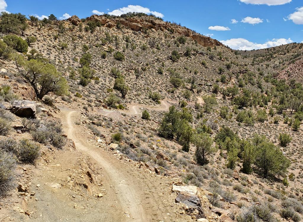
After forking to the right off the larger road, we enter this wash. Not too exciting so far.

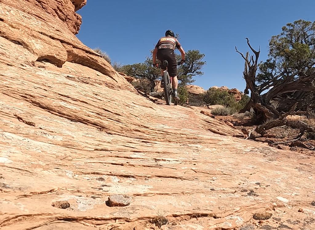
Heading uphill on the Little Canyon Singletrack, an excellent way to ride Bull Canyon.
Option: Mag 7 "Tour de Bridge" with Bull Canyon.
My ride recommendation for Bull Canyon is to combine it with bits of the Mag 7 singletrack for a tour of the top and the bottom of Gemini Bridges. Here's the plan: Up Little Canyon Singletrack to the Bull Canyon road, visit the arches from below and double back. Resume Little Canyon ST, continue on Arth's Corner to Gemini Bridges Visit the arches from above. Now head back down Arth's and Little Canyon. See the mile-by-mile ride directions below.
My ride recommendation for Bull Canyon is to combine it with bits of the Mag 7 singletrack for a tour of the top and the bottom of Gemini Bridges. Here's the plan: Up Little Canyon Singletrack to the Bull Canyon road, visit the arches from below and double back. Resume Little Canyon ST, continue on Arth's Corner to Gemini Bridges Visit the arches from above. Now head back down Arth's and Little Canyon. See the mile-by-mile ride directions below.
Option: Two Tortoise Loop with Bull Canyon add-on.
Another option is to hit Bull Canyon as an out-and-back add-on to the Two Tortoise Loop If done from the bottom of the Gemini Bridges road, that ride is 20 miles; 23.5 if you go all the way up to the turnaround in the upper canyon. If you do only the "local loop" of Two Tortoise Rock, it's about 10 miles.
Another option is to hit Bull Canyon as an out-and-back add-on to the Two Tortoise Loop If done from the bottom of the Gemini Bridges road, that ride is 20 miles; 23.5 if you go all the way up to the turnaround in the upper canyon. If you do only the "local loop" of Two Tortoise Rock, it's about 10 miles.

A bit further up Bull Canyon.

The canyon gets deeper. The rocks tend to keep this area cool for longer in the day.
Option: Classic Bull.
The "classic" Bull Canyon ride is a simple dirt-road crank up the Gemini Bridges road to the Bull Canyon road. Or, as is more often done, as an out-and-back off the Gemini Bridges road when you're riding it top-to-bottom as a shuttled ride.
The "classic" Bull Canyon ride is a simple dirt-road crank up the Gemini Bridges road to the Bull Canyon road. Or, as is more often done, as an out-and-back off the Gemini Bridges road when you're riding it top-to-bottom as a shuttled ride.
From the Gemini Bridges road, Bull Canyon starts out wide and smooth. After 0.1 mile, you'll
pass the Little Canyon Singletrack crossing. At 1.2 miles, you'll pass
the Two Tortoise Rock
trail coming in from the left side.

Parking area for the hike to the bridges. My Superfly 100 is all alone.

Starting the hike to the arches. The Gemini Bridges are straight ahead to the "fluted" wall, then to the left.
At 1.6 miles from the Gemini Bridges, there's a critical fork. The broader fork veers slightly
to the left, and continues to the Dry Fork of Bull Canyon -- not the one
you want. Bull Canyon
forks 90 degrees right and promptly drops into a wash. You might think
you took the wrong fork
until you see carsonite trail posts later on.
The walls of the wash become deeper and become tall cliffs of Wingate sandstone. There are
a few sandy patches, but with a 29er, 2.1 tires, and a bit of speed I
could ride them all.
There aren't any tech sections. It's just straight-ahead dirt-road riding
while you enjoy the
scenery.
At 3.2 miles, you'll reach the hiking trail to Gemini Bridges. I didn't see a "no bikes" sign, but the carsonite marker showed only a "hiker" icon. So I assume you're NOT welcome to ride up the hiking trail. The trail is 0.6 miles long, arriving at a spot under the arches.
At 3.2 miles, you'll reach the hiking trail to Gemini Bridges. I didn't see a "no bikes" sign, but the carsonite marker showed only a "hiker" icon. So I assume you're NOT welcome to ride up the hiking trail. The trail is 0.6 miles long, arriving at a spot under the arches.

The bridges from below.

As I return from the bridges, my bike has company.
I had the whole canyon to myself on the way in. It was cool and peaceful. As I came back from
the arches, a whole herd of ATVs had arrived. By the time I returned from
the dead-end in the
upper canyon, there were 25 vehicles in the parking area and more arriving.
Early morning is
definitely the time to ride.
The usual turn-around spot is the foot trail to below Gemini Bridges. But the trail continues
another 1.6 miles up the canyon then dead-ends. Just before the end, a
side path goes down
into the canyon to old mines. It also dead-ends. So stay high and enjoy
the view at the end.

On the dead-end upper canyon, about a mile from the bridges trail.

View up Bull Canyon from the turn-around.
Turn around and bomb back down the ATV track. Few vehicles venture beyond the parking area
for the bridges trail, so you've got the canyon to yourself.
Once you're back on the main Bull Canyon road (after rejoining the Dry Fork road), consider
a variation on your ride. Two Tortoise Rock and the Little Canyon Singletrack
are alternate
ways down the mountain.

Looking east down the canyon. On the skyline is the Gold Bar Rim area.

View of the trail as we head back down the wash.
Classic Bull Canyon out-and-back:
0.0 From Gemini parking, start south and uphill
N38 39.378 W109 40.689
4.6 Keep R on Gemini, steep uphill section N38 36.040 W109 40.454
(L = Gold Bar to Little Canyon ST or Two Tortoise)
5.1 Fork L on Bull Canyon road N38 35.807 W109 40.867
5.2 Pass Little Canyon ST N38 35.729 W109 41.007
6.3 Keep straight (L = Two Tortoise Rock trail)
N38 34.934 W109 40.899
6.7 Fork R and enter wash N38 34.934 W109 40.899
8.3 Hiking trail to arches N38 34.914 W109 42.027
9.4 Keep R uphill N38 34.557 W109 42.933
9.9 End of trail, turn around N38 34.318 W109 43.356
With Two Tortoise, from Gold Bar:
Park at "Dead End" 0.5 miles up Gold Bar
0.0 L uphill N38 35.830 W109 40.221
0.1 Pass Gold Bar Singletrack N38 35.881 W109 40.143
0.6 Fork R on Two Tortoise N38 35.866 W109 39.742
2.6 Fork R (L = dead end) N38 34.797 W109 40.306
2.8 Keep L N38 34.830 W109 40.379
3.4 L on Bull Canyon Rd N38 34.934 W109 40.899
3.8 Fork R and enter wash N38 34.934 W109 40.899
5.4 Hiking trail to arches N38 34.914 W109 42.027
Double back
7.4 Pass Two Tortoise N38 34.934 W109 40.899
8.4 L on Little Canyon ST N38 35.737 W109 41.006
9.8 L downhill on Gold Bar N38 35.881 W109 40.143
9.9 Back at parking

Eastbound on the Gemini Bridges road on the way back.
Mag 7 Tour de Bridge (w Little Canyon and
Arth's):
0.0 From Gemini parking, start south and uphill
N38 39.378 W109 40.689
4.6 Fork L on Gold Bar Rim
N38 36.040 W109 40.454
5.1 Keep L, start uphill
5.2 Fork R on singletrack marked in yellow
N38 35.881 W109 40.144 Easy to miss!
6.6 L on Bull Canyon road N38 35.729 W109 41.007
7.7 Keep straight (L = Two Tortoise Rock trail)
N38 34.934 W109 40.899
8.1 Fork R and enter wash N38 34.934 W109 40.899
9.7 Hiking trail to arches N38 34.914 W109 42.027
Hike then head back the way you came
12.8 L on Little Canyon ST N38 35.735 W109 41.005
13.6 Cross Gemini Bridges road to Metal
Masher
N38 35.773 W109 41.620
13.7 L on Arth's Corner singletrack
N38 35.856 W109 41.653
15.2 R on Gemini Bridges road
N38 35.246 W109 42.238
15.4 L toward bridges N38 35.271 W109 42.400
15.6 Foot trail to top of bridges
N38 35.233 W109 42.604
Retrace to Arth's Corner
17.6 Little Canyon ST
18.4 Cross Bull Canyon rd
19.3 L on Gold Bar
19.9 R on Gemini
24.5 Back at TH

Bull Canyon area map
Getting there:
Gemini Bridges TH. From I-70 drive south on US-191 for 22 miles. From Moab, drive 7 miles north of the Colorodo. Turn west (left if you're coming from Moab) into the parking area. GPS N 38° 39.381' W 109° 40.672'. To avoid a parking fee (private lot), go across 191 to the Bar M parking.
Gold Bar Rim road parking. (Use this parking spot for shorter rides heading uphill on the Little Canyon Singletrack or the Two Tortoise Rock trail.) Drive up the Gemini Bridges road 4.6 miles, and fork L toward Gold Bar Rim and drive along the wash 0.5 miles. You can park near the wash at N38 35.849 W109 40.304. Begin by riding up the hill.
Bathroom: Gemini TH
Water: none
Camping: primitive on Gemini Bridges Rd (bring your toilet!)
Riding resources for this trail:
Single-page riding guide
GPS track files (right-click and "Save as..."):
Local track files
Wider area tracks
Bull Canyon Only
Mag 7 Tour de Bridge
Two Tortoise w Bull Canyon
High-res topo for printing (1.2 MB): View
Lodging, camping, shops: Links to Moab area resources
Single-page riding guide
GPS track files (right-click and "Save as..."):
Local track files
Wider area tracks
Bull Canyon Only
Mag 7 Tour de Bridge
Two Tortoise w Bull Canyon
High-res topo for printing (1.2 MB): View
Lodging, camping, shops: Links to Moab area resources