Looking northeast toward the town of Manti. Review       ride by Bruce on June 9, 2025.
Looking northeast toward the town of Manti. Review ride by Bruce on June 9, 2025.
Buffet Trail

When complete, the Buffet Trail will be 7 miles long. The trail crew is currently working at mile 6.3 (as of June 9, 2025) but they say you're welcome to ride up to the work area before turning back. (This is a hand-built trail. They're completing the surface finish work as they go. Just be very conservative as you ride the newer stretches so you don't mess up the berms and surfacing!)

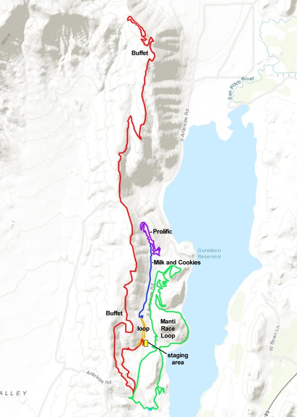
The Buffet Trail starts just west of the race staging area for the Manti Race Loop (across the gravel road from the kiosk area). The trail is usually done as an out-and-back, but there are other options such as using the Prolific plus Milk and Cookies trail to create a shorter loop ride. There's also a dirt road that can deliver you to the top for a shuttled ride.

Overall, this is an intermediate-skills ride. The length of the out-and-back (14 miles) and the overall climbing (1400 feet) make this a trip for well-conditioned riders. Less-strong riders -- or riders without a lot of free time -- can do a loop that combines the lower half of Buffet with the downhill limb of Prolific plus Milk and Cookies.
Bruce heads onto a rock drop on the downhill.
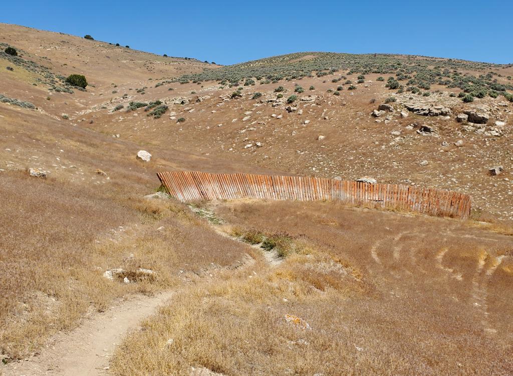
Note the sea of hot dead cheat grass! This wall ride       is just uphill from the trailhead.
Note the sea of hot dead cheat grass! This wall ride is just uphill from the trailhead.
The trail is a hand-built bench-cut, so the riding track is fairly narrow at around 18 inches. Turns are nicely banked but the trail has a more-natural feel than a machine-built route.

There are a few stunt opportunities. Rough limestone outcrops create rock roll-overs, short drops, and rock ramps on the mid-elevation stretches of trail. The only man-made tech features are a ramp and a wall hit.

The area is highly sun-exposed. That opens up a longer riding season (April through November), but it also means that afternoons are very hot during the summer.

The bottom of Buffet is at 5480 feet elevation, just west of the Gunnison Reservoir and the Manti Race Loop. Buffet climbs climbs 1000 feet in elevation, but there are several stretches where you'll coast a bit downhill. So the climbing to get the top (6450 feet elevation) is a bit over 1200 feet, and your overall climbing for an up-and-back will be over 1400.
Looking southeast at Gunnison Reservoir.
Trailhead
Looking down at the race staging area. The little       lack dot is my car.
Looking down at the race staging area. The little lack dot is my car.
"Finish Line" parking

From US-89 in Manti, turn west just south of the temple to get onto 500 North westbound. Drive west on 500 North, and after 1.7 miles it will become gravel River Road and turn to head northwest. At mile 2.8 from US-89, fork to the left to head south. At the fork at mile 3.3, turn R to head west. The road will then turn to the south again at mile 3.9. At mile 6.6 you may note the bottom of the Prolific Loop on your right as the road turns a bit to climb a small rise. The road then continues south. At mile 7.4, keep straight as a road forks to the left (heading for the Day Use Area). You'll spot trails on both sides of the road here, but keep going. At mile 7.7 just before the road approaches a climb, there's a spot to park on your left where another dirt road joins. On your bike, come back to the main road, turn right uphill then veer left onto singletrack.

Notes on the Buffet Trail
Pedaling north through cheat grass, rock outcrops,       and juniper.
Pedaling north through cheat grass, rock outcrops, and juniper.
From the "finish line" parking spot, go to the main gravel road. Turn left to pedal gently uphill about 100 yards. (You're backtracking on the road you drove to get here.) Now veer left onto singletrack (the first of two trails that fork uphill from the road as you pedal north).
The trail will take a 180-degree turn after 500 feet and immediately join another singletrack. Keep straight, and you're now heading south.

Just 30 feet later, the trail splits. Take the left (downhill) trail. (The trail to the right will climb up and around to become the warm-up loop, with a connection to the northbound Milk and Cookies trail.)

Bruce pedals through juniper on a newly constructed       section of trail.
Bruce pedals through juniper on a newly constructed section of trail.
Looking north across the shake-out road from the race       singletrack entry of the race loop. Mid-right is the way back to the       trailhead. The trail above (upper left) is Buffet heading up the hill.
Looking north across the shake-out road from the race singletrack entry of the race loop. Mid-right is the way back to the trailhead. The trail above (upper left) is Buffet heading up the hill.
The singletrack heads generally south, steadily gaining elevation. (There's 200 feet of elevation gain in the first mile.) At mile 0.9 from the warm-up loop trail fork, one mile from parking, the trail arrives at the top of the gravel road "shake-out" portion of the race loop. The singletrack of the race loop is right across the road.

(There are a couple of primitive doubletracks that cross the trail as you approach the main road. Keep straight and don't be suckered into turning onto any of these DTs. When you've reached the main road it will be obvious.)

To continue on Buffet, veer right uphill on the gravel road for 30 feet, then turn sharply to the right on northbound singletrack.

The trail continues to climb, with 100 feet of elevation gain over the next half-mile. You'll now reach a long traverse. The route is fairly flat with gentle climbing and descending. There will be almost continuous views of the lake and valley to your right.

Around mile 2.5 the trail will begin climbing again. The trail follows a line just east of the ridge of the mountain. Stretches of juniper will alternate with open stretches of cheat grass.

Meandering through juniper and rock outcrops as we       climb.
Meandering through juniper and rock outcrops as we climb.
The views are almost constant, even when in the       junipers.
The views are almost constant, even when in the junipers.
As you get higher on the hill, there will be sage meadows alternating with juniper slopes. The trail still falls on the east-facing slope, just downhill from a ridgeline.

You may occasionally spot a dirt road uphill to your left -- this can be a bailout route if you have problems. (The road begins to parallel the trail around mile 1.5 from the trailhead. This road can be reached, either for emergencies or as a shuttle route, by driving the "shake-out" road another half mile uphill, then turning right and right again to a narrower northbound doubletrack.)

At mile 3.5, the singletrack crosses a doubletrack. To your left, you'll see that it joins the bail-out/shuttle road. Downhill 1/4 mile, this doubletrack arrives at the top of the Prolific loop. The DH portion of Prolific connects to Milk and Cookies for a return to the trailhead area. This creates a fairly easy and quick loop ride.
Climbing along the edge of the juniper forest. The       doubletrack to Prolific/Milk and Cookies is just ahead.
Climbing along the edge of the juniper forest. The doubletrack to Prolific/Milk and Cookies is just ahead.
A look down toward Gunnison Reservoir.
Assuming you want to continue uphill on Buffet, cross the doubletrack and keep climbing.

Buffet ends at a gentle hill at the top of the ridgeline. The plans call for a small loop here. In June 2025, the trailworkers are at mile 6.3. So this final piece should be finished sometime this summer.

On the cllimb, this ramp lifts you above a       mean outcrop.
On the cllimb, this ramp lifts you above a mean outcrop.
And here it is on the downhill. Cushy.
In the downhill direction, the narrowness of the trail may spook some riders as it twists around junipers on the side-slope. Adjust your speed to a comfortable clip and you'll be fine. Some of the rock outcrops also feel very different in this direction.
Rolling into a banked turn, around 1/3 mile from the       summit. The dark area is an area of fresh berm reinforcement. Don't mess       up the trailwork!
Rolling into a banked turn, around 1/3 mile from the summit. The dark area is an area of fresh berm reinforcement. Don't mess up the trailwork!
Hugging the side-slope on the way down.
Some stretches have enough down-slope to rip downhill by simply coasting. But there's a lot of flat riding, and more than a bit of climbing. Overall, you'll add around 200 vertical feet to your climbing total as you go back to the trailhead from the summit.

From the top down

[Back to video list ]
Bottom Line!

Nice ride. It can be an after-race ride for the family at a NICA event or just an early-season outing. I thought Buffet was a solid and interesting ride, worth the two hours I drove from the Wasatch Front. But given a choice of area trails, most riders would opt for Ephraim Canyon -- if the snow has cleared.

Wall hit!
Wall hit!
Zoomed-out area map.
Getting there:
From US-89 in Manti, turn west just south of the temple to get onto 500 North westbound. Drive west on 500 North, and after 1.7 miles it will become gravel River Road and turn to head northwest. At mile 2.8 from US-89, fork to the left to head south. At the fork at mile 3.3, turn R to head west. The road will then turn to the south again at mile 3.9. At mile 6.6 you may note the bottom of the Prolific Loop on your right as the road turns a bit to climb a small rise. The road then continues south. At mile 7.4, keep straight as a road forks to the left (heading for the Day Use Area). You'll spot trails on both sides of the road here, but keep going. At mile 7.7 as the road approaches a climb, there's a spot to park on your left, just as another dirt road joins on the left. (The smaller road on the left is the finish-line sprint for the race, and the main road is the shake-out sprint to start the race loop.) To find Buffet, go to the southernmost of two singletracks on the west (uphill) side of the main road as described in the trailhead info above.

Note that there are NO road signs to guide you to the riding area from Manti. And no "you have arrived" or "park here" signs. You'll need to follow the instructions above!

Camping: no
Water: none
Bathroom: none