

The Breaks Trail is a 3.4 mile intermediate route on the far southern side of the Iron Hills riding area. It's a two-way trail, although if you decide to climb Breaks it will become obvious that it's engineered as a DH trail. At the top, Breaks begins at the end of Tombstone (a two-way expert-level trail). At the bottom, Breaks ends on Turnpike just north of the Pyramid trailhead.
The Breaks trail can be done as an up-and-back, but most riders will want to do it downhill after climbing Elevate then Tombstone. This makes a nice loop!
There's 950 vertical feet of elevation change on Breaks, with a starting elevation at the top of just over 7000 feet. The expected riding season will be mid-May through October.


The trail is named after the "breaks" -- the exposed colorful cliff-like slope you can see to the northeast from the trailhead area. But Breaks doesn't actually run through the breaks. Instead it starts on a ridge above, where there's a nice view, then drops down the slopes to the east and then south of the cliffs.


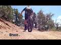
The trail is mostly highly engineered dirt ribbon. Turns are highly banked and seem obviously built for the downhill direction. But with a bit of leg, you can climb up and around.
Occasional trailside rock rollovers offer options for more aggressive riders.
 trailhead.")
The Pyramid Ridge trailhead is just off the gravel Shurtz Canyon Road south of Cedar City, surrounded by the Pyramid Ridge campground. From the southern Cedar City exit, head south on Old Highway 91 just east of I-15. At 2.4 miles, turn left on Tipple Road. After 0.6 miles, turn left on Shurtz Canyon Road (mislabeled "Shirts" on the road sign). Go 0.7 miles and turn left into the trailhead. Veer left from the campground road into a large fenced parking area signed Pyramid Ridge Trailhead.
The Pyramid Ridge campground is administered by the BLM. Reservations are required and should be done on-line. Campsites are improved with gravel parking and tent site, picnic tables, and fire pits.
The Turnpike trail begins eastbound at the break in the northeast side of the fence. Cross the ride-over at the border of the campground, then pass the Roundabout trail on your left. To climb Breaks, turn right at mile 0.2 from the trailhead parking.


At the southern I-15 Cedar City exit (Exit 57 to Cross Hollow Road and Highway 130), turn east onto Highway 130. Immediately turn right (south) from 130 onto Old Highway 91. Drive 0.3 miles. Watch for the sign for Southview Trailhead and turn left on Shurtz Canyon Drive and continue to the trailhead at the end of the road.
There's a bathroom with running water, a bike repair stand, a privacy-screen for changing clothes, and ample parking. On the paved Southview trail, go 100 yards until you cross the bridge. Now turn to the right at the first singletrack after you cross the bridge, which is Turnpike. It will take you south to the trails that connect with Breaks.

From the top of Tombstone, Breaks actually climbs a bit for a quarter mile. You're on the ridgeline just above the cliffs of the breaks.
Stop at the viewpoint to look over the "breaks" from above, then hop back on the trail to begin a blazing downhill.


The trail wiggles back and forth and up and down, then the direction changes at a broad highly-banked turn.
The terrain is clay soil with pinion pine and juniper. There's almost no under-story vegetation.


The final quarter mile before Breaks ends on Turnpike is also pretty flat. But it twists around, and there are quite a few rocks to dodge during this stretch.

This is a very nice trail that adds significant value to the Iron Hills system. It's obviously best in the downhill direction. The only downside -- for most riders -- is the lack of an easy climbing route to the top.
Pyramid Ridge Trailhead
The Pyramid Ridge trailhead is just off the gravel Shurtz Canyon Road south of
Cedar City, surrounded by the Pyramid Ridge campground. From the southern Cedar
City exit, head south on Old Highway 91 just east of I-15. At 2.4 miles, turn
left on Tipple Road. After 0.6 miles, turn left on Shurtz Canyon Road
(mislabeled "Shirts" on the road sign). Go 0.7 miles and turn left
into the trailhead. This trailhead has a bathroom and large fenced parking area
within the campground. The Turnpike trail begins eastbound at the break in the
north east side of the fence.
At the southern I-15 Cedar City exit (Exit 57 to Cross Hollow Road and Highway 130), turn east onto Highway 130. Immediately turn right (south) from 130 onto Old Highway 91. Drive 0.3 miles. Watch for the sign for Southview Trailhead and turn left on Shurtz Canyon Drive and continue to the trailhead at the end of the road. Pedal 3.2 miles south on Turnpike to reach the northern end of Scenic Byway, 4.3 to Roundabout.
Both trailheads have water, toilet, and bike tools.


