")
View west from the Siler Bluff loop. Photos and ride review by Bruce on December 3, 2022.
Bloomington Hill ("MegaZen" area)
(Mega Zen, Bloomington Hill, Bloomington Rim, Siler Bluff Loop)
(Mega Zen, Bloomington Hill, Bloomington Rim, Siler Bluff Loop)
This page describes the trails on the eastern side of Bloomington Hill near St George. Many riders use these trails as a descending path from the Zen Loop , but there are loop ride options from the bottom of the hill as well. All except upper Mega Zen are two-way and can be done as (tough) climbing trails. While short, these trails require good skills and strength.
The trails lie on a tilted layer of Shinarump conglomerate. Bloomington Hill angles upward
from northeast to southwest. These trails lie on the northwest side of
the cliffs. Below the
cliffs is the valley containing the
Bearclaw Poppy
area trails.
There are no "easy" rides here. All except the Siler Loop should be considered expert. Intermediates who want to ride here should climb the Powerline Road to Siler Bluff road and ride the Siler Loop. Then pick among various trails in the downhill direction -- planning to make a few walk-overs as you go.
There are no "easy" rides here. All except the Siler Loop should be considered expert. Intermediates who want to ride here should climb the Powerline Road to Siler Bluff road and ride the Siler Loop. Then pick among various trails in the downhill direction -- planning to make a few walk-overs as you go.

Looking over the edge of the cliffs at the Bearclaw Poppy trailhead on the western edge of Bloomington.

extended loop ride Making the final drop from Mega Zen down to the Siler Bluff Road (a left turn here connects to the Bloomington Rim trail for further technical descending).
In describing these trails, I will refer to the trail from the
Zen
loop over to the Siler Bluff road as "Mega Zen." It will be divided into two segments: an upper
one-way high-expert DH section from Zen to the Powerline Road, and an
upper-intermediate section
from Powerline to Siler Road.
The term "Mega Zen" can also refer to the of Zen that combines Mega Zen with some combination of the lower trails plus dirt roads that link back to Zen. So the Bloomington Rim trail can also be considered part of Mega Zen.
The term "Mega Zen" can also refer to the of Zen that combines Mega Zen with some combination of the lower trails plus dirt roads that link back to Zen. So the Bloomington Rim trail can also be considered part of Mega Zen.
Getting to the trails

End of the pavement on Curly Hollow. Expect this area to change as further subdivision development occurs.
Bad weather / low-clearance sedan parking
On Tonaquint Drive between Dixie Drive and Bloomington Drive, turn west on Curly Hollow Drive. Go past the school and continue to the end of the pavement. Start the ride by pedaling up the dirt road. Follow the directions below.
On Tonaquint Drive between Dixie Drive and Bloomington Drive, turn west on Curly Hollow Drive. Go past the school and continue to the end of the pavement. Start the ride by pedaling up the dirt road. Follow the directions below.

At the border of the Trust Lands is this primitive trailhead. Low-clearance vehicles should not drive here.
Bloomington Hill Trust Land trailhead
At pavement's end on Curly Hollow Drive, the dirt road turns left. It will pass a race staging area as it climbs a low hill. After cresting the hill, keep straight as the Curly Hollow doubletrack forks to the right. Descend past the fenced power station property and turn left. Drop into the washbottom, then turn to the right and begin to go uphill on the main dirt road. About 50 feet from the bottom of the wash, fork right into a parking area. Begin the ride by climbing the Powerline Road. Alternates: The Wash Trail is on the left 50 feet uphill from the parking entrance. After 100 yards on the Wash trail, the Bloomington Rim trail will fork to the right uphill.
At pavement's end on Curly Hollow Drive, the dirt road turns left. It will pass a race staging area as it climbs a low hill. After cresting the hill, keep straight as the Curly Hollow doubletrack forks to the right. Descend past the fenced power station property and turn left. Drop into the washbottom, then turn to the right and begin to go uphill on the main dirt road. About 50 feet from the bottom of the wash, fork right into a parking area. Begin the ride by climbing the Powerline Road. Alternates: The Wash Trail is on the left 50 feet uphill from the parking entrance. After 100 yards on the Wash trail, the Bloomington Rim trail will fork to the right uphill.

Bruce tackles the far wall of "the bathtub" on Zen. Made it.
Via the Zen Trail
From the Green Valley competition area, start uphill on Zen riding counterclockwise. At mile 2.9, as you ride east-southeast along the edge of the cliffs, the Zen trail will curve to the left away from the edge. A less-obvious trail continues straight here, dropping steeply down through a technical area. This is upper Mega Zen, a high-expert (double-black) downhill-only trail that will take you to the rest of the trail system. This trail has significant exposure to cliffs and is extremely technical.
From the Green Valley competition area, start uphill on Zen riding counterclockwise. At mile 2.9, as you ride east-southeast along the edge of the cliffs, the Zen trail will curve to the left away from the edge. A less-obvious trail continues straight here, dropping steeply down through a technical area. This is upper Mega Zen, a high-expert (double-black) downhill-only trail that will take you to the rest of the trail system. This trail has significant exposure to cliffs and is extremely technical.
General area information

Looking down the escarpment from the shinarump cliffs. The trails below are part of the Bearclaw system.
Bloomington Hill is formed from a tilted layer of Shinarump conglomerate overlying the clays
and sandstone layers of the Chinle formation. The rock starts out level
with the valley but
tilts up so that as the cliffs break away down toward the Bearclaw Poppy
area, 300 feet of
elevation has been gained.
Compared to the layers underneath it, the Shinarump tends to resist eroding away. As water
attacks the surface, it breaks down into slabs, nuggets, and domes. In
crevices and soil between
"bumps" of rock, brittle sage, ephedra and cactus grow.
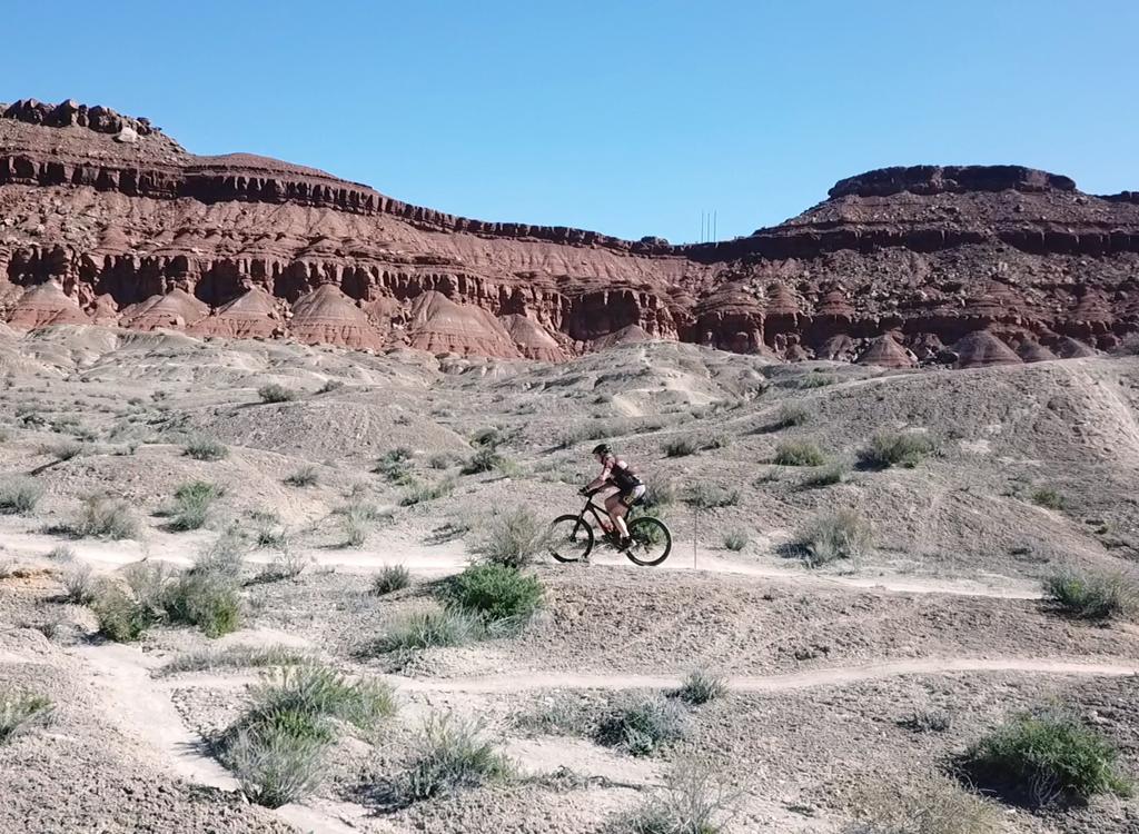
While some areas have smooth rock, mounds and ledges are common. This creates the riding challenges that expert riders want. But it's a lot of work. Except for the Siler Loop, the trails here are expert-level in the either direction, with a dash of extra challenge when heading uphill.
While some areas have smooth rock, mounds and ledges are common. This creates the riding challenges that expert riders want. But it's a lot of work. Except for the Siler Loop, the trails here are expert-level in the either direction, with a dash of extra challenge when heading uphill.

Typical terrain. Bumps of sandstone separated by crevices of dirt. This is the lower section of Bloomington Rim, heading uphill.

Looking downhill on a smoother bit of sandstone. That's the trailhead in the middle of the photo.
With no trees to block the view, you'll be able to enjoy open views in many directions. To
the north are the Pine Valley Mountains. Northwest are the red Navajo
sandstone cliffs of Snow
Canyon. You'll be able to spot the mesas to the east past Bloomington.
On the trails below Mega Zen, navigation and route-finding can be tricky. There are no trail
signs and no paint spots. Even on weekends, it's unlikely that you'll
find another biker to
ask directions. An occasional out-of-place rock may be the only marker
of the trail. For a
first-time ride, it's significantly easier to find your way when riding
top-to-bottom. And
if you have a specific route in mind, use a navigation aid such as Trailforks.

Looking north toward the Pine Valley Mountains from the Siler Loop.
Mega
Zen upper DH segment

Narrow singletrack hugs a steep side-slope on upper Mega Zen. Don't look to the right.
Mega Zen (called "The Art of Motorcycle Maintenance" after the book "Zen and The Art of Motorcycle
Maintenance" by the trailbuilders) is 1.5 miles in length, extending from
the Zen trail loop
east to the Siler doubletrack near the Siler Loop. It includes an upper
one-way DH portion
and an easier two-way segment. The upper half of Mega Zen is rated "double-black."
Only confident
true experts should ride this trail!
The upper section of Mega Zen is 0.8 miles long, with 300 feet of elevation loss. There's only
a little bit of climbing, but it's sudden and steep. This portion of Mega
Zen is a highly technical
and challenging trail with exposure to steep side-slopes and cliffs.

Rolling over a ridgeline through nuggets of sandstone.

Ramp up.
Upper Mega Zen forks away from the counterclockwise Zen loop as Zen turns away from the cliffs
to begin descending north. Compared to Zen, the Mega Zen trail is relatively
narrow and faint.
So you'll need to be watching for it.
The descent begins with steep winding trail through the sandstone. You'll drop 100 vertical feet in 1/10th mile. The route will then level out, although the degree of challenge remains high. Mega Zen has quite a few expert-level rock challenges, with wooden ramps for some bigger rocks.
The descent begins with steep winding trail through the sandstone. You'll drop 100 vertical feet in 1/10th mile. The route will then level out, although the degree of challenge remains high. Mega Zen has quite a few expert-level rock challenges, with wooden ramps for some bigger rocks.
After a half mile on top of the hill, the trail dips down below the upper cliff line. Here
Mega Zen runs along a steep side-slope in the Chinle formation clay just
below the Shinarump
caprock and just above a second set of cliffs. There will be some up-and-down
and a bit of
rock-dodging.

Cruising between two cliff-lines.

The trail descends down ripple-stone slabs before turning above the cliff. Between the "red stuff" and the "gray stuff" at the top of the photo is 300 feet of air.
At the eastern end of upper Mega Zen, the trail will drop steeply. Once again, you'll lose
about 100 feet of elevation in 1/10th mile. And the drop-off is never
far away.

As you bounce over the last challenge, you'll see the power poles ahead. Here we're looking back up at the final drop.

Near the end of upper Mega Zen. Before you reach the power poles, the singletrack turns off to the left.
Just before the doubletrack turns at the power poles, the singletrack cuts across to the left
of the road. After joining the road for a few feet at the bottom of the
dip, it will climb
through several switchbacks to get up above the road again.
The trail now drops down and across the Powerline road. If you're done, simply turn left and head downhill on the road. For (a lot) more work, veer downhill across the road to enter the lower segment of Mega Zen. This will take you to the Bloomington Rim trails for more tech riding as you descend.
The trail now drops down and across the Powerline road. If you're done, simply turn left and head downhill on the road. For (a lot) more work, veer downhill across the road to enter the lower segment of Mega Zen. This will take you to the Bloomington Rim trails for more tech riding as you descend.

Crossing the Powerline Road.
Mega
Zen lower section

Some rock challenges early in the lower segment.
The next section of Mega Zen is 0.7 miles. The trail now becomes two-way. There will be around
100 feet of climbing and 200 feet of descending as the trail continues
east. You're away from
the cliffs and riding across the slope of the hill.
This portion of Mega Zen would rank upper-intermediate overall, with a short bit of expert-level
rock on each end. There are some long stretches of simple pedaling but
also periodic rock challenges
that require good skills.

And a bit of smoother riding as we pedal through "Brigham Tea" ephedra bushes.

Descending a rock ramp down to the sage flat.
The trail winds through brittle sage and ephedra. The long non-technical stretch in the middle
of this segment is a welcome respite.
Around 1/10th mile in, a sketchy trail comes from downhill on your left. You may not see it. This trail heads out to the Powerline road. Keep right and eastbound.
Around 1/10th mile in, a sketchy trail comes from downhill on your left. You may not see it. This trail heads out to the Powerline road. Keep right and eastbound.
As the trail approaches the Siler Bluff dirt road at mile 1.5 from Zen, it will drop through
some challenging rock. If you keep turning to the left after the initial
drop, you'll find
the top segment of the Bloomington Rim trail on the left. (You'll turn
a total of 180 degrees.)
This is the way to go if you're doing Mega Zen without the Siler Loop.
If you point the bike down the second set of steep rock ramps, you'll reach the Siler Bluff road, where a right turn will take you to the Siler singletrack loop. A left turn on Siler Road is the quick way downhill if you're going to bail on further tech riding.
If you point the bike down the second set of steep rock ramps, you'll reach the Siler Bluff road, where a right turn will take you to the Siler singletrack loop. A left turn on Siler Road is the quick way downhill if you're going to bail on further tech riding.

Approaching the end of the trail. The doubletrack of Siler Bluff road can be seen along the cliffs ahead.
Top section, combined Bloomington Rim and Bloomington Hill trails

This is a short connector between lower Mega Zen and upper Bloomington Rim. You don't need to drop all the way down to the road unless you want to hit Siler Loop before continuing down.
The Bloomington Rim trail is a series of trail segments that descend 2.1 miles from the bottom
of Mega Zen to the Wash trail at the Bloomington Hill trailhead. These
are two-way trails,
but have significant expert-level challenges and tough climbing whichever
direction you go.
For simplicity of navigation, I'll describe a continuous route that keeps to the right at the
trail forks from this point downhill. That seems to be where most riders
are going.
While these are two-way trails, the layout and the "sight clues" seem designed for a downhill ride. If you choose to climb them on your first time here, expect to spend a bit of time looking for the continuing trail, blowing past trail forks, and squinting at Trailforks on your phone. By comparison I had only rare moments of "Dude Where's My Trail?" during the descent.
While these are two-way trails, the layout and the "sight clues" seem designed for a downhill ride. If you choose to climb them on your first time here, expect to spend a bit of time looking for the continuing trail, blowing past trail forks, and squinting at Trailforks on your phone. By comparison I had only rare moments of "Dude Where's My Trail?" during the descent.

The trail curves around the hillside through outcrops of sandstone.

The band ahead is Siler Bluff road. We're heading northeast.
The top segment is 0.3 miles long. Here the Bloomington Rim and Bloomington Hill trails are
combined. This section extends from the bottom of Mega Zen to the first
trail fork.
At this fork, a right turn takes you on a meander referred to as Bloomington Rim South or Upper Bloomington Rim, while left puts you on a shorter alternate descent via the Bloomington Hill trail that will bypass the meander.
At this fork, a right turn takes you on a meander referred to as Bloomington Rim South or Upper Bloomington Rim, while left puts you on a shorter alternate descent via the Bloomington Hill trail that will bypass the meander.
Bloomington Hill alternate descender upper section

The trail heads past a couple of large barrel cactus, with the Pine Valley Mountains in the background.
The upper Bloomington Hill alternate trail forks away from Bloomington Rim at mile 0.3 from
Mega Zen. It's a faster way down than the upper meander of Bloomington
Rim (see below). The
trail fork occurs just as the upper descending trail makes a curve downhill
to the right, and
it's easily overlooked. If you see the Silar Road ahead, you went past
the trail fork.
There will be a faint trail on the left about half-way down this section. This will take you out to the Powerline road. Keep right and descend toward Siler Road.
There will be a faint trail on the left about half-way down this section. This will take you out to the Powerline road. Keep right and descend toward Siler Road.
This section of Bloomington Hill is 0.3 miles long, as it will rejoin Bloomington Rim at the
Siler Bluff doubletrack.
At the Siler DT, Bloomington Hill joins the doubletrack northbound. At the same spot, the lower limb of upper Bloomington Rim comes in on the opposite side of the road. Keep straight onto the dirt road and find the continuing singletrack trail veering to the right. The Bloomington Hill and and Bloomington Rim trails will now be combined for 1/10th mile.
At the Siler DT, Bloomington Hill joins the doubletrack northbound. At the same spot, the lower limb of upper Bloomington Rim comes in on the opposite side of the road. Keep straight onto the dirt road and find the continuing singletrack trail veering to the right. The Bloomington Hill and and Bloomington Rim trails will now be combined for 1/10th mile.

Crossing the Siler Bluff road to join Bloomington Rim.
Bloomington Rim upper (south) meander

Rolling and bouncing through the sandstone. Yes, that's the trail straight ahead.
The upper meander of Bloomington Rim begins at a trail fork 0.3 miles downhill from the bottom
of Mega Zen. Go to the right for 1/10th mile and cross the Siler Bluff
dirt road. You'll enter
an area of rolling nugget sandstone. Things get a bit bumpy here!
At the eastern end of the meander, there's a stretch of fairly easy singletrack trail. But
it's short. Enjoy it while you can.

A bit of smooth cruising. Not every inch is techy.

Looking back at a couple of rock drops as the lower meander heads down into the wash. The trail actually descends along the steep slope at upper left. Impossible to do it slow.
The route will turn back to westbound and begin dropping into a rocky wash. There's some very
technical rock here. You may need to take a scouting look, then back up
and make your run.
Once you're in the washbottom, the trail continues west on a gentle climb. When you reach the
Siler Bluff dirt road at mile 0.9 from the top, veer to the right onto
the road, then right
again on the continuing singletrack trail. (If you notice a trail joining
on the left side
of the road, that's the Bloomington Hill trail. The two trails now join
for the next 1/10th
mile.)

Heading gently uphill toward the Siler Bluff road and the junction with the Bloomington Hill trail.
Middle Segment, Combined Bloomington Rim and Bloomington Hill

After the lower meander of Bloomington Rim forks away, the Bloomington Hill trail is fairly faint, as most riders are choosing to ride the Bloomington Rim route.
The Bloomington Hill and Rim trails are joined for 1/10th mile during a climb from Siler Bluff
Road to the top of a low hill. Then the Rim trail will fork to the right,
while the Bloomington
Hill trail goes left. If you turn left downhill on Bloomington Hill (bypassing
the 0.7 miles
of Bloomington Rim's lower meander), it will be 0.3 miles to rejoin the
Rim trail.
Bloomington Rim lower (north) meander

A bit of dirt gives a respite from bouncing around.
After 1/10th mile on the combined Bloomington Rim/Bloomington Hill trail (mile 1.0 from the
bottom of Mega Zen via Bloomington Rim), keep to the right at a trail
fork. The fainter trail
to the left is the Bloomington Hill trail. (If you decide to go left,
you'll rejoin the Rim
trail after 0.3 miles.)
This section of Bloomington Rim is 0.7 miles long. It will curve out to the east twice before
returning to join the Bloomington Hill trail on the eastern side of a
shallow wash. Look for
cairns above the wash to mark the cross-over spot. At the shallow wash,
you're at mile 1.7
of the descent on Bloomington Rim.
It's likely you won't even see the Bloomington Hill trail coming in to join Bloomington Rim. The junction is about 30 feet east of the wash. This piece of the Hill trail can be hard to find even when you know exactly where it is. You could, for example, turn left and use Bloomington Hill as an uphill route to do a second lap of the lower Bloomington Rim meander.
It's likely you won't even see the Bloomington Hill trail coming in to join Bloomington Rim. The junction is about 30 feet east of the wash. This piece of the Hill trail can be hard to find even when you know exactly where it is. You could, for example, turn left and use Bloomington Hill as an uphill route to do a second lap of the lower Bloomington Rim meander.

The trail goes just right of center in this photo.

Rolling through domes of sandstone as we head north.
If you're climbing uphill from the bottom segment and want to ride Bloomington Hill instead
of the lower Bloomington Rim meander, pedal until you can see a couple
of cairns marking the
wash crossing. On the east side of the wash, just past the marker rocks,
work your way to the
right and find a path along the eastern side of the wash going uphill.
It will be 0.3 miles
to where Bloomington Hill and Bloomington Rim rejoin. (Note that when
climbing, Bloomington
Rim turns to the left and gently downhill after crossing the wash, while
Bloomington Hill turns
right uphill.)
Bottom segment, combined Bloomington Rim and Bloomington Hill trails

Wash crossing, heading north. The faint Bloomington Hill trail has just joined on our left.
Back to the descending route. We're now at mile 1.7 from the bottom of Mega Zen.
After crossing the little wash, veer right and downhill on a long rock ramp. You're now on the final section of the descent. Navigation should be easier now. When in doubt, aim the bike downhill.
After crossing the little wash, veer right and downhill on a long rock ramp. You're now on the final section of the descent. Navigation should be easier now. When in doubt, aim the bike downhill.
This bottom segment is 0.4 miles long, and will include the short connection up the Bloomington
wash to the trailhead.
As you approach the wash, the rock challenges will get steeper. (I found some sections of this trail to be non-rideable in the uphill direction.) Again, there's a spot where you may have to look around a bit to find the continuing trail. The navigation problems will get better as more people ride the trail.
As you approach the wash, the rock challenges will get steeper. (I found some sections of this trail to be non-rideable in the uphill direction.) Again, there's a spot where you may have to look around a bit to find the continuing trail. The navigation problems will get better as more people ride the trail.

Beginning the final section.

Dropping steeply down into a shallow ravine.
As the trail drops into the wash, veer left uphill and pedal to the Powerline Road.
To connect to the bottom of Zen for the "Mega Zen" ride, pedal north out of the wash on the dirt road. Keep left at the road fork (instead of retracing the drive in). There will be two connectors to lower Zen, both on the left. One comes at mile 0.4 and connects to Zen above the sharp drop into the final wash. The second is at mile 0.6 at the fence. Pedal up into the wash and watch for the trail to your right.
To connect to the bottom of Zen for the "Mega Zen" ride, pedal north out of the wash on the dirt road. Keep left at the road fork (instead of retracing the drive in). There will be two connectors to lower Zen, both on the left. One comes at mile 0.4 and connects to Zen above the sharp drop into the final wash. The second is at mile 0.6 at the fence. Pedal up into the wash and watch for the trail to your right.
Siler doubletrack and Siler Loop

Climbing up Siler Bluff Road.
The Siler singletrack loop lies on Siler Bluff overlooking northwest Bloomington. The loop
is an easier-intermediate singletrack. It's the easiest trail on the hill
but overall, the
ride isn't really suitable for true beginners, as the dirt-road climb
to the loop is tough.
And there's one section of technical rock to get past, right at the loop
fork.
The loop itself is 1.1 miles of singletrack. It can be reached either via singletrack (lower
Mega Zen in the downhill direction or the top segment of Bloomington Rim
going uphill) or by
a dirt-and-rock jeep road.
The Siler Bluff road forks to the left from the Powerline Road at mile 0.6 uphill from the Bloomington Hill trailhead. (The climb, in my opinion, is too steep for most beginners.) The Siler Bluff Road then extends 0.7 miles south from the Powerline Road to the loop.
The Siler Bluff road forks to the left from the Powerline Road at mile 0.6 uphill from the Bloomington Hill trailhead. (The climb, in my opinion, is too steep for most beginners.) The Siler Bluff Road then extends 0.7 miles south from the Powerline Road to the loop.

Starting the singletrack on a clockwise ride.

On a smooth spot, looking toward Snow Canyon.
When arriving via Mega Zen or Bloomington Rim, fork to the right downhill on the dirt road.
Pedal 0.2 miles. As the road makes a hard right turn to climb steeply
to a viewpoint, keep
straight and find the singletrack fork.
There's one short expert-level section, right at the start of the loop. Less-skilled riders
should simply hike their bike up this section, then start the loop in
the counterclockwise
direction.
Take your time and enjoy the views. There about 150 feet of climbing as you go around the loop.
Take your time and enjoy the views. There about 150 feet of climbing as you go around the loop.

This is the first thing you'll see if you go counterclockwise. Not exactly a "green" trail.

Two sides of Siler Bluff have views over Bloomington.

The third has views over the eastern Bearclaw Poppy area below you.
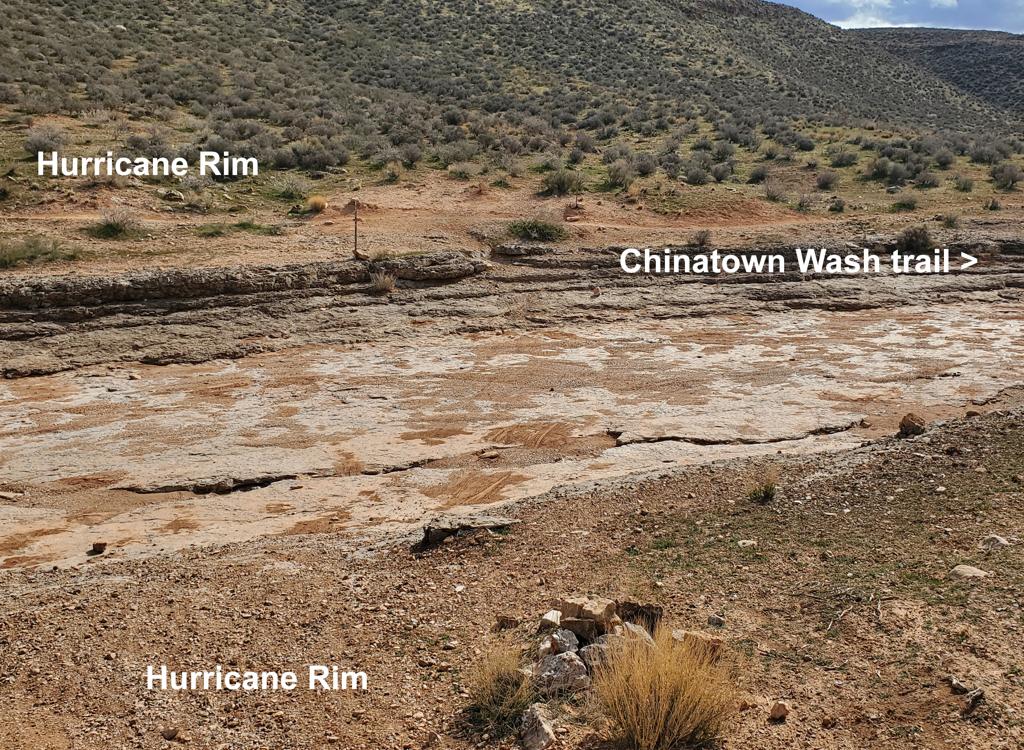
Wash Trail to Bloomington

View east down the wash. The Bloomington Rim trail will fork uphill to the right.
Just uphill and across the road from the trailhead entrance, a doubletrack trail heads east
toward Bloomington. If you stay on the right side of the wash (or in the
washbottom), it will
take you to Tonaquint Drive in just over one mile.

Map of the Bloomington Hill area.
Getting there:
On Tonaquint Drive between Dixie Drive and Bloomington Drive, turn west on Curly Hollow Drive. Go past the school and continue to the end of the pavement. At pavement's end on Curly Hollow Drive, the dirt road turns left. It will pass a race staging area as it climbs a low hill. After cresting the hill, keep straight as the Curly Hollow doubletrack forks to the right. Descend past the fenced power station property and turn left. Drop into the washbottom, then veer to the right as you climb. About 50 feet from the bottom of the wash, fork right into a parking area. Begin the ride by climbing the Powerline Road. Alternates: The Wash Trail is on the left 50 feet uphill from the parking entrance. In 100 yards, the Bloomington Rim trail will fork to the right uphill.
On Tonaquint Drive between Dixie Drive and Bloomington Drive, turn west on Curly Hollow Drive. Go past the school and continue to the end of the pavement. At pavement's end on Curly Hollow Drive, the dirt road turns left. It will pass a race staging area as it climbs a low hill. After cresting the hill, keep straight as the Curly Hollow doubletrack forks to the right. Descend past the fenced power station property and turn left. Drop into the washbottom, then veer to the right as you climb. About 50 feet from the bottom of the wash, fork right into a parking area. Begin the ride by climbing the Powerline Road. Alternates: The Wash Trail is on the left 50 feet uphill from the parking entrance. In 100 yards, the Bloomington Rim trail will fork to the right uphill.
Arriving Via Zen:
Take the Bluff Street I-15 exit in St. George and turn west. Immediately turn south (left) at the first light. Go over the hill and at the T intersection at the bottom of the hill turn right. Head northwest about two miles on Dixie Drive. Turn left at Canyon View Road, heading uphill toward the Green Valley Spa. (If you reach a "Green Valley Market" with gas pumps, you just passed it. Turn around and backtrack to the second road on your right.) Drive past the spa onto dirt at the end of the road. Turn right at the top of the mesa, then immediately left to drive down into the deep valley. Head for the big road that goes up the bluff, on the right side of The Gap -- the sandstone canyon. But just before that road starts to climb, mosey to the left and park where you can start riding up the doubletrack on the LEFT (south) side of the sandstone canyon. At mile 2.9 of Zen, veer right as the trail turns left.
Take the Bluff Street I-15 exit in St. George and turn west. Immediately turn south (left) at the first light. Go over the hill and at the T intersection at the bottom of the hill turn right. Head northwest about two miles on Dixie Drive. Turn left at Canyon View Road, heading uphill toward the Green Valley Spa. (If you reach a "Green Valley Market" with gas pumps, you just passed it. Turn around and backtrack to the second road on your right.) Drive past the spa onto dirt at the end of the road. Turn right at the top of the mesa, then immediately left to drive down into the deep valley. Head for the big road that goes up the bluff, on the right side of The Gap -- the sandstone canyon. But just before that road starts to climb, mosey to the left and park where you can start riding up the doubletrack on the LEFT (south) side of the sandstone canyon. At mile 2.9 of Zen, veer right as the trail turns left.
Riding resources for this trail:
GPS multi-track area files (right-click, "Save as..."): "MegaZen" area
Lodging, camping, shops: Links to St. George area resources
GPS multi-track area files (right-click, "Save as..."): "MegaZen" area
Lodging, camping, shops: Links to St. George area resources