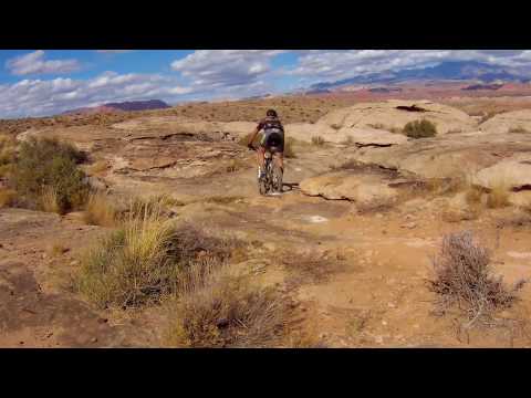
Dave rockets past barrel cacti on the Barrel Trail in April 2012. Original review 2008, latest update Novcember 2017.
Barrel Trail at Green Valley
First, to avoid confusion: This is NOT the "Barrel Roll
Trail" of the Santa Clara Desert Preserve. This is the Barrel Trail,
also called "Barrel Ride."
Second: Access to the trails became difficult in
late 2025 due to subdivision construction across the Green Valley Bearclaw
Poppy trailhead access road. The instructions at bottom of this page are
current for November 2025. Best to check with a local shop for current
conditions and parking recommendations.
The Barrel Trail starts across from the north end of the Bearclaw
Poppy Trail. It extends up to the Green
Valley hillclimb trail, connecting just above the top of the DH portion of
the Green Valley Race Loop, and has branches that connect to the upper and
lower end of that DH. Barrel is also the south half of the Cactus Hugger
race course, riding counterclockwise and using Barrel as the
downhill.
Named for the many huge barrel cacti along the trail, the Barrel Trail lies on the slope of
a cuesta just southwest of St.George. There are multiple riding options
including longer loops
with significant climbing and quick excursions. The southern end, in fact,
might seem confusing
if you don't have a solid travel plan.
If you're new to the area, it helps to ride with someone
who knows which trail options have the hairy stuff, and which are appropriate
for intermediate
riders.

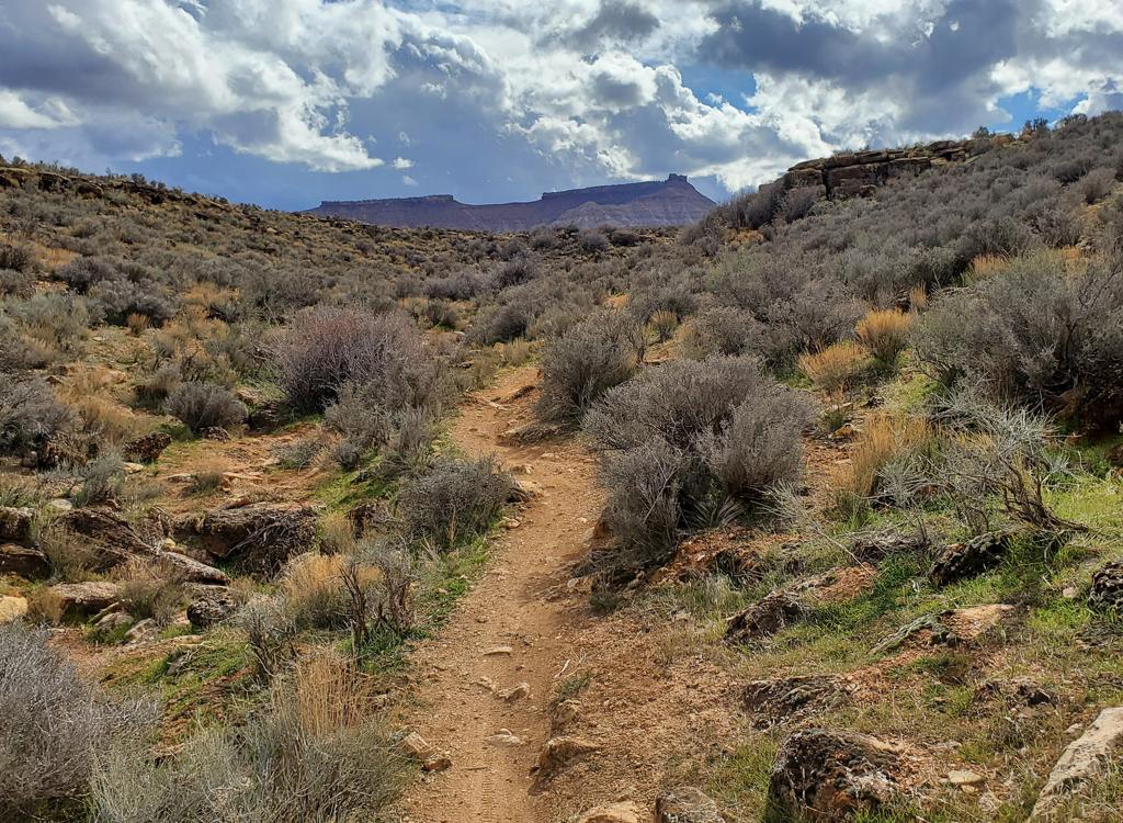
View up the trail as we're climbing from the Bearclaw end of the trail. Ride description and original photos by Bruce on January 9, 2008. Fellow trail explorer, Jackie the Jack Russell terrier.

Bruce hits the steepest rock ramp on the Barrel.
And attention, freeriders! The Barrel Trail also accesses some extreme-tech stunts as an option
for the skilled and/or daring. Below I describe a five-mile loop ride
starting from the Green
Valley trailhead. It climbs to the top of the mountain, then flirts with
the edge of the cliffs
overlooking the
Stucki Springs
area. This route is for upper-intermediate to advanced riders. The stunts are for skilled tech
riders only.
For those who just want a tiny ride, or want to get to the rock playground more quickly, start
at the Bearclaw Poppy trailhead. It's just one mile to the top of the
playground, and most
of the climbing is on the gravel road from the parking area to the water
tank.

Some miniature barrel cacti bloom in the April sunshine.

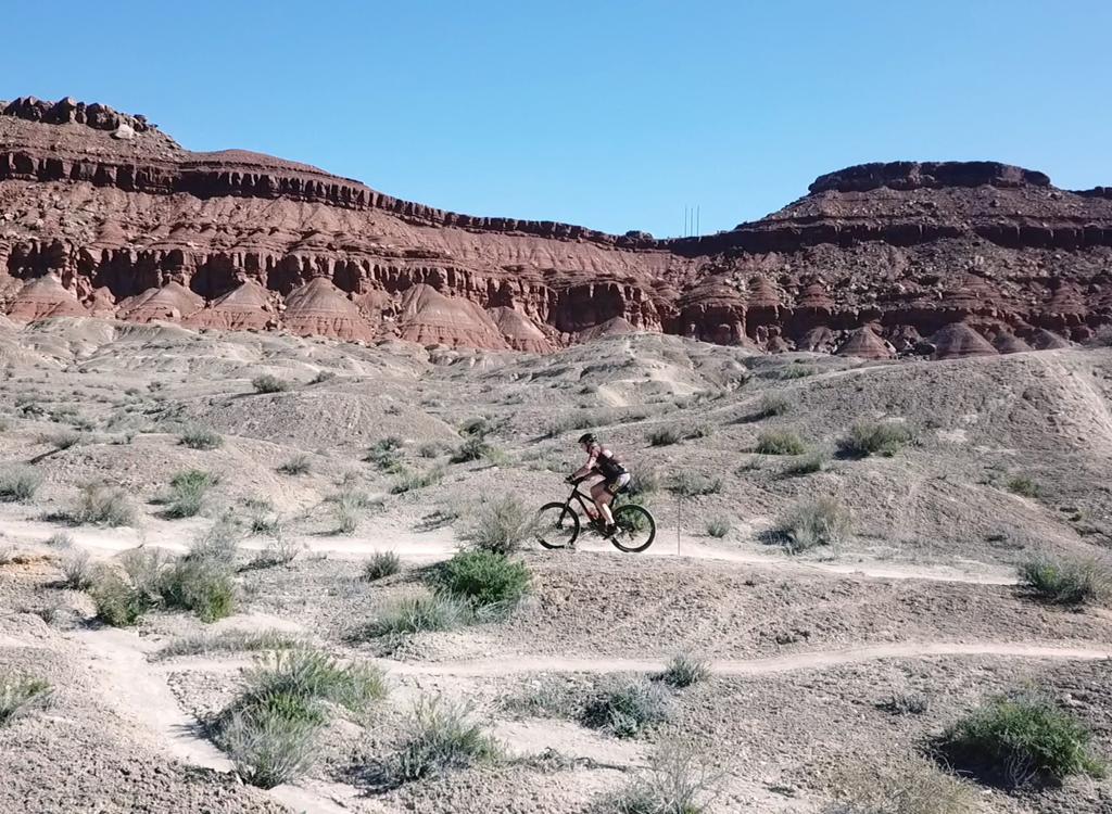
Getting closer to the top on the counterclockwise loop.
The trail also offers a short-cut version, through a connector to the Green Valley race trail
about 1/4 mile below the spot where the hillclimb splits from the loop.
This takes you to the
trail in the rock wash below the lower Stucki Springs viewpoint (see map).
The trail is over 50% rock. There's a broad area of pure slickrock near the top, where the
trail is marked by rockpiles (cairns). Most of the rock is slabs and rollovers
on the trail.
There are some nice views of the Pine Valley Mountains to the north,
and of the red cliffs of the
Snow Canyon
area.

On top of the hill, with views going forever to the south.

Suitable for a roll-down, wheelie drop, or a huck. Just stay loose and go, but get your hands off the brakes. The trail splits here. You have the option of riding smooth dirt, or playing on some sphincter-tightening stuff.
Intermediate riders can manage with short sections of hike-a-bike. The ride starts at 2600
feet elevation, rising to 3300 (more, if you climb to the awesome viewpoint
overlooking
Stucki
Springs
). Total climbing will be about 1100 feet. There are plenty of small ledges and rocks to bang
over.
An alternative method (and one I recommend) for the big loop is to start at the
Bearclaw Poppy
trailhead, then descend to intersect the
Green Valley
loop just before it heads across the big slickrock area and begins to climb. On the long descent,
after passing the rocky playground, keep left to rejoin the outgoing trail
about 100 yards
from the water tank at Bearclaw Poppy's step-over.

There's plenty of technical rock, but also alternate lines and even entire trail options that bypass the gnar.

View north on a connector from the water tank road at the top of Bearclaw Poppy. The playgrounds are formed of nugget sandstone.
I've gone clockwise on the big loop, but the trail seems better taken counterclockwise (north
to south after climbing to the top). There's a steep tech section about
1/3 mile south of the
top that's extremely tricky to descend and impossible to ride up.
There are two stunt areas. The bigger one is on the south end, 1/2 mile from the water tank.
There are gap jumps, drops, and scary descents. There are multiple lines
offering varying crazy
tricks, so explore a little. If you're up to it, stay and play.

Here's a nice drop. What's not obvious in the photo is the distance between the cliff edge and the landing ramp. You've gotta hit it with enough speed to clear three feet. My guess is, 5 feet from lip of cliff to top of ramp. There's an alternate roll-down to the left of this, but it's not easy either.

Here's another barrel cactus, as we approach a tire-trapping dip. For perspective, the cactus is about 4 feet high.
The second set of stunts is on the fainter connector trail that links the trail near the first
playground to the beginning of the slickrock area on the GV racecourse.
(From there, you can
hold right to reach an ATV-track that takes you back up.) I do NOT recommend
trying to fight
your way up through the rock here.
Because it remains snow-free all year, St. George is a great biking destination even in January.
But in the winter you have to be satisfied with shorter rides. In the
photo at right, it's
only 3 pm, but already the shadows are getting long and the air is getting
chilly. The Barrel
Trail offers enough riding and climbing to satisfy, with stay-and-play
options to keep you
on the mountain until the evening chases you off.

This ramp above offers a different take -- instead of launching off a rock to a transition ramp, you hit the ramp with speed and launch up onto the rock. Failure to clear the gap is not recommended.
Quickie Loop, or access to playground:
0.0 Start at Bearclaw trailhead
N37 05.340 W113 38.457
Head up doubletrack
0.4 Just before water tank, R on ST
N37 05.181 W113 38.824
0.5 Fork L on narrower track
N37 05.227 W113 38.810
0.6 Keep L (connector from ATV joins)
N37 05.351 W113 38.821
0.7 Straight past playground exit (on L)
N37 05.400 W113 38.785
0.8 Fork R for quick loop
N37 05.454 W113 38.699
(L=climb up big loop clockwise
or go to top of playground)
0.9 R uphill on DT
N37 05.441 W113 38.614
At crest, stay on DT and through
wash
1.1 Keep L (R=connector)
N37 05.315 W113 38.711
1.2 Pass 1st fork
1.3 L down road
1.7 At parking<
Big Loop via GV raceway,
figure 8:
0.0 Start at GV trailhead
Pick trail heading west into tiny
wash
N37 05.340 W113 38.457
Veer north on first DT west of the
wash
0.5 After cresting hill, fork L to cross wash
N37 05.665 W113 38.348
0.6 Coming out of wash, veer R on ST
N37 05.608 W113 38.381
Keep R again
N37 05.607 W113 38.443
Climb up onto slickrock area, head
across
0.7 Steep climb!
1.5 Keep R (L = shortcut to Barrell)
N37 05.574 W113 39.300
1.7 Fork L (R = Green Valley Loop)
N37 05.519 W113 39.447
1.9 L uphill on DT
N37 05.442 W113 39.696
2.0 Fork L on ST
N37 05.422 W113 39.727
(option: straight to viewpoint 1)
2.3 Extreme tech plunge
2.4 Fork L (R=viewpoint 2)
N37 05.345 W113 39.447
2.6 Keep R (L=return to GV trail)
N37 05.490 W113 39.368
3.6 Keep L for loop trail
N37 05.405 W113 38.862
(options on R=playground)
3.8 Fork R (L=tech DH route)
N37 05.491 W113 38.734
3.9 Keep L (R=bottom of playground)
N37 05.454 W113 38.699
4.0 Fork L on ATV track
N37 05.441 W113 38.614
(R=climb to Bearclaw TH)
4.1 ATV track joins on R
4.3 Rejoin uphill route
N37 05.608 W113 38.381
Immediately! fork R
Follow R side of wash to fence
4.9 Through fence, cross wash
Veer L to parking
5.0 At car

NOTE! The entire area east of the Bearclaw trailhead, including the spot labeled as "GV trailhead", is now being developed as a subdivision. You must start from the Bearclaw trailhead, or work your way into the area from trails to the north. See the full area map below..

From the Green Valley Bearclaw trailhead, you can navigate through the Barrel trail system.
Northern (Green Valley) Bearclaw trailheadYou can reach the race loop by connecting through the Barrel Trail
system from the Bearclaw Poppy
northern trailhead. From Dixie Drive in southern St George, turn onto
Canyon View Drive and go all the way to the top. Turn right at the
"T"
then follow the road as it curves downhill and left. When you hit the
bottom, turn to the right on the road that climbs up the slope and follow
it 1/3 mile along the edge of "The Gap" canyon to the Bearclaw
parking area. The Rowe trail starts at the parking area, while the Blue
Barrel trail is located up the dirt road across from the Bearclaw Poppy
step-over gate. The simplest connection is to go up the road, then find
the trail on your right and follow it generally downhill and northeast
until you hit the border of the subdivision, where you'll find Reacharound
to start the loop.

To the north are the red cliffs near Snow Canyon.
From Eastern Cove WashIn St. George, head north on
Bluff Street and turn left on Sunset Blvd. Drive 3 miles west on Sunset
through Santa Clara. As you're reaching the end of Santa Clara, look for a
road crossing the river on your left. It's about 200 feet before the Jacob
Hamblin Home (which will be on your right if you pass the turn). Turn and
cross the river. About 0.4 miles
from Hwy 191 as the paved road turns right, cross to the dirt Stucki Springs road as it climbs
steeply south. At mile 0.7, keep left at the sign "Cove Wash
Trailhead" to stay on the Stucki Springs road. Keep left again at the
next fork. At the bottom of a wash, begin your ride heading left (east).
As you approach homes a mile later, keep left to find the singletrack
climbing along cliffs up to the race loop.

Navigating the narrow passage through Keyhole Wash.
Via SunbrookTurn off Dixie Drive onto Sunbrook Drive. Follow it all the way west
until you hit a "T" intersection. Turn right aind a roadside
spot to park. Look for a singletrack trail that crosses the wash heading
west. The first left fork is the route up Keyhole Wash between the homes.
The second is the connector singletrack running uphill to the west along
Box Canyon Wash. As you reach the hillside above the homes, keep right to
start a counterclockwise lap on the race course. At the top, connect over to the Barrel Trail.

Map of Green Valley area in 2025
Getting there: Southbound,
take the Dixie Drive exit from I-15 and turn to the right. Keep on Dixie
for a couple of miles to reach Canyon View Drive. Drive up and over the
hill to reach the road to the Green Valley Bearclaw trailhead.
Alternatively, stay on Dixie Drive for another mile and turn left on
Sunbrook. Go to the end, and at a T interection, turn right and find a
place to park. Catch a trail heading west on the south side of a small
canyon.