Maple Hollow to Ann's Trail
This short trail is a two-way trail that links western Ann's Trail to the Maple Hollow trailhead at the top of Suncrest. This is a smooth trail with a gentle rate of climb or descent. Ann's Connector is 1.1 miles in length.
Ann's Connector creates some loop opportunities. It provides the uphill return route from the Maple Hollow DH trail. Ann's Connector also allows riders to descend to Ann's Trail, ride a nice big loop through Corner Canyon, then climb back uphill.
More recently, Ann's Connector is used by riders who are heading to Traverse Mountain's trail system. After climbing the top of the hill on Traverse Traverse from westbound Ann's, riders can connect to the Mayors Trail or Mo-mentum.
 is the route to Eagle Crest.")

The Dobbins Way trail (new in 2025) runs between the middle of Ann's Connector and the northern side of the Mayors Trail in the Traverse Mountain system. The fork is located 0.7 miles above Ann's and 0.4 miles below the Maple Hollow trailhead.
This trail also ties to Eagle Crest on the south side of Traverse Mountain. After you climb up to the Maple Hollow trailhead from Ann's, just turn left on the broad cinder path. Pass under the road, then turn left for the Eagle Crest singletrack (your route to Vertigo, etc), or keep right for south Maple Hollow.

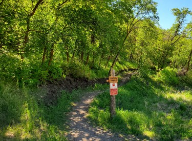
The Maple Hollow trailhead provides direct access to Ann's Connector and the Maple Hollow DH trail. At the four-way stop at the top of Suncrest, get onto Deer Ridge Drive. Drive west for just under one mile. As you reach Deer Ridge trailhead, turn to the right at Elk Glen Drive instead of entering the trailhead. After 100 yards turn left into the Maple Hollow trailhead parking area. Ann's Connector is straight west past the kiosk.
There are no services at this trailhead.

The newer Deer Ridge trailhead offers more parking, plus bathrooms, picnic tables, and water (including a bike-washing and water-bottle filling station). To use this trailhead, go to the end of Deer Ridge Drive as above, but go into Deer Ridge trailhead and park. Find the singletrack that goes north to the Maple Hollow trailhead. It's located next to a picnic table on the northern edge of the parking strip.


When first built in 2013, the main use of this trail was an uphill route from the Maple Hollow DH. From the original trail description: At the bottom of Maple Hollow DH, go downhill a tad and hop the westbound BST (Bonneville Shoreline Trail) as it emerges from the underpass on the uphill side of Traverse Mountain Road. Climb through the gully and fork left on Ann's Trail at the ridge after 1/2 mile.


Ann's Connector has opened up a lot of riding possibilities "on top of the mountain." While it's not an exciting ride by itself, it's a critical link in many heavily-used new routes.


GPS track files (right-click and select "Save Target as..."):
Ann's Connector only
Draper Area Trails GPX
Draper Rim Loop only
Ann's Trail only
Topo map for printing: View
Corner Canyon area trail overview page
Lodging, camping, shops: Links to southern SLC resources