Looking southeast toward Bald Mountain from the Silver King trail on the system's northern side.
Prospector View Park
(Santaquin Canyon)
The Prospector View Park trails are located in lower Santaquin Canyon.
In addition to modern engineered trails, the system includes the
older Santaquin Creek trail along the creek and Santaquin
Bench trails across the ridge to the north. Review by Bruce June 5, 2023,
with latest update May 28, 2024.
There are around 7 miles of new trail in loop rides near the
trailhead,
with connecting trails offering options for bigger rides. The trail system starts at 5600 feet elevation and is located a bit over a mile
uphill from
town in Santaquin Canyon.
The expected riding season will be late May to mid-November.

Bruce
hits an uphill switchback while climbing the Brownstone trail on the
system's southern side.

Looking west down the canyon we see West Mountain and
Goshen Bay of Utah Lake.
The trail system lies on both sides of Santaquin Creek. The
north side is directly connected to the Prospector View trailhead via the
Silver King or Bacon trails. These are easy trails, with the option of a
shorter loop of lower Silver King and Bacon or a longer loop of Silver
King to Pipeline and down the eastern DH for the return.
From the top of the big loop at Pipeline, you can connect to the
Santaquin Bench trails for a longer ride.
The south-side trails are reached via a connector off lower
Silver King. You'll cross the road, then the creek, before arriving at a
multi-trail intersection. Here you can ride Turkey Run (formerly known as
the Santaquin Creek trail) or climb Little May or Brownstone. Like the
north side, you'll have the option of shorter or longer loop rides. At the top of the big Little May/Brownstone loop, Little May
continues uphill for a longer ride.

While the north side is dry grass and tiny groves of
scrub oak, the southern side offers maple-forest riding and plenty of
greenery!

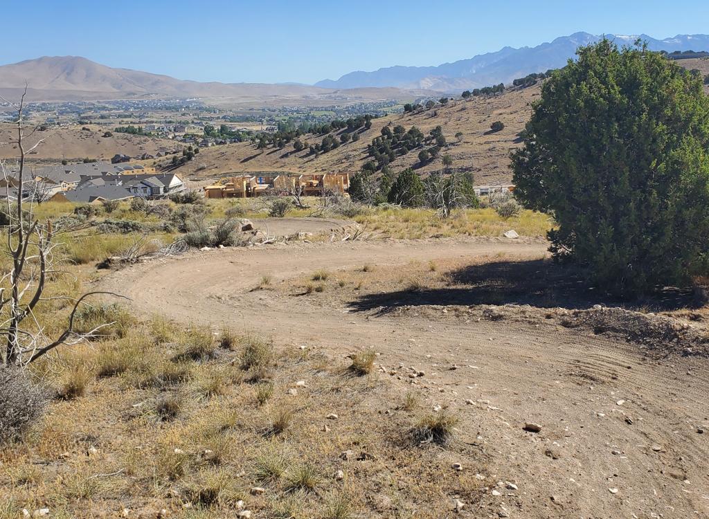
Looking east into Santaquin Canyon from the Prospector View trailhead.
Prospector View TrailheadThe trailhead is located just off the Santaquin Canyon Road. It has a
toilet and ample parking. From I-15, get off at the US-6 - Santaquin Main
Street exit and turn east toward the mountains. Turn right on Highland Drive
and go one mile south. Turn left on Canyon Road and drive 1.9 miles,
turning left into a cindered road that climbs 100 feet to the trailhead.
As you face uphill, Silver King goes to the left and Bacon goes to the
right. To reach the trails across the canyon, take Silver King and keep
left to Little May, descending to cross the road and the creek.

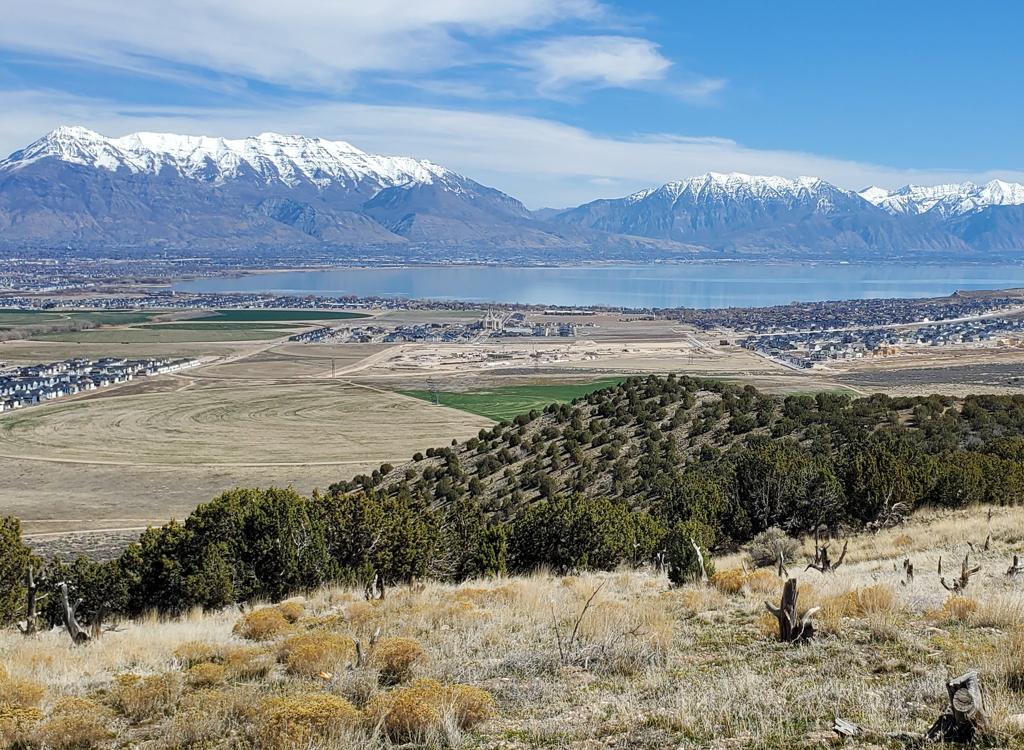
Looking north toward Utah Lake and Timpanogos from the Upper East Bench trail.
Via Santaquin Bench TrailsYou can catch the Santaquin Bench trails at the southern end of either
400 East or 1000 East. Begin climbing, working uphill and south. The two
trails will join just before a small loop. Go either way. When in doubt,
go south. You should arrive at a broad ridgeline where two singletrack
trails merge as they cross a faint doubletrack. Around 100 yards later,
fork to the right on a less-obvious trail. (The main trail will descend
steeply down a ravine to the road.) This newer trail, the
East Bench Connector, will curve around to the right (westbound) and join
the trail system at a fence crossing. Now the first trail on the left is
the unfinished DH trail and the second is the two-way Prospector View. Straight ahead is
a short rough out-and-back to the old pipeline.
North Side Trails
Silver King Trail

Climbing up from the Prospector View parking area. Above the oak brush, you
can see three passes of the trail higher on the hill.
The Silver King Trail starts at the Prospector View trailhead
and climbs the hill to the north. It's a two-way general-use trail. The trail is 1.1 miles long with 350
feet of elevation gain. It begins on the western side of the parking area
and ends on the Pipeline trail, where you can connect to the eastern DH route or
to the Santaquin Bench Connector.
Fork right and uphill as you approach a picnic table. The trail to the
left descends to cross the road and the creek to the south-side trails.
Silver King is a wide machine-cut trail. Turns
are mildly banked. The berms are not sufficient to hold you on the trail
at high downhill speeds. So ride in control.
The terrain is typical Wasatch-foothill clusters of gamble oak, with more lush
vegetation as you gain elevation. You'll have views to the east of
Santaquin Canyon, and of southern Utah Valley to the west as you
switchback across the south-facing slope.

Traversing the slope eastbound, looking up Santaquin Canyon.

Heading west, with a bit of Utah Lake appearing. The climb is not continuous, with frequent flat or mildly down-sloping areas.
To ride the lower loop, keep straight and left at mile 0.5
and you'll be on the Bacon trail for the downhill. For the big loop, veer
left and continue your climb.
At mile 1.1 from the trailhead, you'll come to a T
intersection. To the left is the Pipeline trail (see below). To the right
-- and continuing across the fence -- is the Santaquin Bench Connector. If
you fork downhill to the right just before the fence, you're on the east
(upper) DH
route.

Looking east at the Santaquin Canyon road from Bacon.
The Bacon trail provides a short loop option on
easy trails. Or it can be a downhill route after riding the east (upper)
DH trail from Pipeline. The Bacon trail is 0.5 miles long, for
a loop of almost exactly one mile when combined with the lower half of
Silver King.
At mile 0.6 of the climb up Silver King, keep straight
as the main trail turns uphill to the left. Keep straight and slightly
downhill again as the DH
route crosses. Bacon will now begin a slow descent. The trail ends as
it reaches the trail kiosk at the parking area.

Looking down at the turns on Bacon.

A bit of pipeline breaks the surface.
The Pipeline Trail follows the old water pipeline for around 100 yards before it becomes too
rough and overgrown to ride. Only the iron support rings remain. Water pipelines were often
build of wood with iron rings for support, holding the wood together like the rings on a wooden
barrel.
At the fence to the east, Pipeline continues as the Santaquin Bench
connector.
Santaquin Bench Connector

Climbing up the draw toward the ridgeline.
The Santaquin Bench Connector trail starts at the top of Prospector View. Turn right from Prospector
View, then keep straight and cross the fence. The fence is the border between Santaquin's trail
system and the National Forest. (The trail heading downhill just before the fence is the unfinished
DH route.) After heading east a bit, the trail climbs a shallow draw. Just before the top of
a flat ridge at mile 0.3 from Prospector View, the trail joins the East Bench trail. A hard
right turn would take you steeply downhill to the road. Keep left. (Remember this spot if you're
coming back!)
Attention! Trail names are changing in this area. The upper Bench trail
and the old DH have been labeled as "Silver King" on Trailforks.
This may create some confusion.
When you reach a faint doubletrack on the ridgeline (just before mile 0.4), the singletrack
splits. Northbound to the right is the Upper East Bench trail. Angling
northeast on the left
is the Upper Loop trail. Either trail can take you down to the streets
of Santaquin, if you
just keep heading downhill.
A popular loop ride for locals is up the Santaquin Bench trails, down Prospector View, across
the creek and down Santaquin Canyon, then back to the street you started
on via the paved bike
path along Highland Drive.

Heading more west-bound on the Upper Loop. It's around 2 miles to reach subdivision streets.
Downhill Trail
(upper section open)

Heading south away from Pipeline.
The top of the DH route is to your right as you reach the
top of Silver King. In May 2024, only the upper portion is complete.
You'll continue your downhill either on Silver King or Bacon.
The entrance to the upper DH is on Pipeline, just east of the top of
Silver King.
The upper DH is 0.4 miles long. The unfinished lower segment will be 0.3 miles. The total vertical drop is 350
feet over 0.7 miles. The DH will be expert level riding, with some steep
drops, ramp-ups, and jumping lips.

A lip, a plunge, and a steep zoom up the
other side.
Connecting to the South Side Prospector View Trails

Nice new bridge leading to the south-side trails.
The
Santaquin Creek Connector forks to the left from
Silver King at mile 0.1 from the trailhead. The trail is signed as Little
May. It descends and crosses
the canyon road, then drops further to the creek. At mile 0.2 there's a bridge across Santaquin Creek.
Continue straight from the bridge until you hit a T intersection with the
Santaquin Creek (Turkey Run) trail.
In the up-canyon direction, Turkey Run is combined with Little May.
Across Turkey Run and veering left uphill is the newer Brownstone trail.

The Little May trail has a very different
feel from the trails on the north side of the road.
To climb the Little May trail, take the connector from
Silver King across the road and across the creek. Turn left on the Turkey
Run (Santaquin Creek)
trail. After 0.2 miles, turn left into the trees at the trail fork. (The continuing
Turkey Run trail straight ahead will let you rejoin Little May uphill, but isn't
as interesting.) The lower Little May trail is considered an easier-level
ride both technically and aerobically.
At 0.2 miles (0.4 from the bridge) the Little May trail
will cross over the Turkey Run trail, changing direction 180 degrees
as it begins to climb the hill. You're now 0.7 miles from the Prospector
View trailhead.
The lower (loop) portion of Little May is 0.7 miles from the fork off
Turkey Run to the top of Brownstone. It's an undulating bench cut that climbs through tall maple forest.
There will be occasional breakout views.

Most of the ride on the lower half of the trail is shaded, with tall forest of mature maples.

Looking up Santaquin Canyon from the trail as I climb.
At mile 0.1 above the Turkey Run cross-over, the short
Higginson loop forks away on your left. The entry and exit are only 150
feet apart. In May 2024, the trail forks have no signs and are easy to
overlook.
After another 0.1 miles, the Shortcut trail forks to the right. It will
take you directly to Brownstone for a short loop ride (or to switch
climbing paths).
The Nils Cutoff trail is 0.1 miles further uphill, forking to the right
as Little May takes a hard left turn. Nils will connect over to
Prospector, and is another option for a loop ride on the lower mountain.
At mile 1.1 from the bridge, lower Little May has a trail fork with
Brownstone if you plan to descend for a loop ride now.
At this trail fork, you can also drop into the Belly Wash DH. To continue riding Little May, turn to the left
to climb narrow singletrack. (More riders are using upper Little May now, so the track has probably improved considerably since I took these photos.)

Looking down toward West Mountain as the Brownstone
trail forks away from Little May.

Sample of trail above the bench cut. This
is pretty plush
when compared to other stretches of unfinished trail.
In
August 2023, the trail above this point was flagged and cleared of
brush, but it was relatively raw riding. Work your way uphill. After 0.4 miles (1.5
from the bridge over Santaquin Creek), turn left on doubletrack, then in 100 yards
turn right to resume singletrack.
At 0.5 miles from the Little May/Brownstone trail fork, you'll cross a cattle
extruder at the forest border. Now the trail will angle downhill and turn
around northbound.

The National Forest border has a fence and
this ride-over
cattleguard. OK spot to turn around and go back.

Heading back downhill, northbound.
At mile 1.4 I reached a turn-around spot for a dirt road and the trail
couldn't be followed. I crossed a log gate and veered to the right on dirt
road. This took me back to Little May (where it joined the
doubletrack at mile 1.1).
Local riders can hop on descending doubletrack to exit the canyon.

Looking northeast at a rare break in the forest.
The Higginson Trail is 1/4 mile long, forming a loop off the
lower Little May trail. It's located 1/10th mile uphill from where Little May crosses over Turkey Run. Most riders take the upper entry to ride Higginson
counterclockwise. The trail is easy, with trivial elevation change.
In May 2024, I rode right past both entries without seeing them as I went downhill on Little May. Hopefully, trail signs and more bike traffic will make the the trail forks obvious.

Entry to the Shortcut from Little May, looking toward
Brownstone.
The Shortcut trail is only 100 feet long, offering a quick
connection between to Brownstone from Little May at 5650 feet elevation.
This offers a short loop ride for less-strong riders, with about 1/2 mile each on Brownstone and Little May.

Nils Cutoff is in the middle of this photo, while the
uphill route on Little May turns 180 degrees to the left.
Nils Cutoff meanders around a shoulder area, linking Little
May to Brownstone just uphill from Shortcut. It's 0.3 miles long, with
around 50 vertical feet of climbing and 100 feet of descending in the
Little May to Brownstone direction. It lies on a "shoulder" of
the mountain where the terrain is relatively flat compared to the hillside
above or below it.
Nils Cutoff offers a slightly-longer "short loop" option when
used with lower Little May and lower Brownstone. It rides well in
either direction.
The DH trail Belly Wash ends on the
middle of Nils Cutoff. Either direction is your "back to the top" route
after completing the DH. Left turn to go to Brownstone, right
turn to go to Little May.

Nils Cutoff meanders through meadows of grass and
sage, with areas of oak and maple forest.

Looking down Belly Wash, with a view to the east up
Santaquin Canyon.
Belly Wash DH begins at the Brownstone-Little May trail
fork. It's 0.3 miles long, dropping 150 vertical feet. It ends in the
middle of Nils Cutoff, where you can connect to either Brownstone or
Little May to climb back to the top.
Belly Wash is an expert-level descent. There are short steep
plunges and some exposed corners on the hillside, but no obligatory
stunts.
When you find yourself at the bottom of Belly Wash, you're on Nils Cutoff. If you go left (west) you'll join the middle of the Brownstone trail. If you go right (east), you'll join the middle of the lower Little May trail.

Handlebar view as we approach a steep drop. You can
roll it or launch it.

As an uphill route, Brownstone has both smooth
forested meandering and bench-cut grunt climbing with tough switchbacks.
The Brownstone trail forks away from Turkey Run just uphill
from the bridge across the creek, ending when it meets the Little May trail at
5800 feet elevation. It's exactly 1 mile long, with 350 feet of elevation
change.
The modest total elevation change is deceptive, as there are areas
of stiff climbing on lower Brownstone that make it an intermediate-level
trail. The lower half of Brownstone also has some tight switchback turns
that require good leg strength and skill in the uphill direction, and good
braking and steering control downhill.
Brownstone connects to the Shortcut trail at mile 0.4 from
the bottom, then to Nils Cutoff at mile 0.5. After climbing around a small
summit -- with nice views over southern Utah Valley -- it ends on Little
May.
Many riders prefer to climb Little May and
descend Brownstone because of the steepness of the lower half of
Brownstone.

Bruce rolls into a dip on Brownstone.

At a viewpoint bench on Brownstone looking east up
Santaquin Canyon. Around the hill is another bench looking west over
southern Utah Lake and West Mountain.
Compared to Little May, Brownstone offers more views, both
up-canyon to the east and across southern Utah Valley to the west.
Brownstone makes a nice loop ride when combined with Little May.

Looking down the lush upper doubletrack portion of Santaquin Creek.
The Santaquin Creek trail is an older ride that follows
ancient pipeline corridors along the creek. It has now been adopted by the
Prospector View recreation area and has been renamed "Turkey
Run." The trail is 1.5 miles long and consists
of alternating sections of singletrack and doubletrack.
From the spot where the Santaquin Creek Connector trail reaches the
Turkey Run trail, it gently climbs 0.4 miles uphill to a blind end.
On the way, the Little May trail forks uphill at mile 0.2.
There are a couple of connectors from the Santaquin Canyon road. The lowest is just uphill from the power station and retention basin, with a gravel road closed by a metal gate (the bike ride-around is left of the gate). There will be three other road links between this lower entry and the Santaquin Creek Connector trail.
Because there's no parking in these locations, I recommend that you park at the trailhead and enter the Santaquin Creek Trail from uphill.

South end of the Turkey Run (Santaquin Creek) trail. If you enter
here (pedaling from down or coasting down the road from the trailhead)
you'll veer to the left to find the uphill trail.

A view into the creek.
Santaquin Creek runs alongside the trail but you'll see it only occasionally. At mile 0.8 downhill from the Santaquin Creek Connector trail, there's a diversion dam. From there until the end of the trail, there will only be water in the creek during non-irrigation months or high-flow situations.
The first 0.2 miles downhill from the Connector is doubletrack in deep forest. Then the doubletrack veers across the creek. Keep left and find a narrow singletrack in the trees. This section is a bit sketchy for less-skilled riders. Because the trail is now part of the park, I expect will be widened and smoothed so that beginning riders and kids can pedal this part.

Leaving the easy doubletrack for the sketchy singletrack.

The singletrack is narrow, with encroaching shrubs and trees.
The singletrack will run for 0.2 miles. You'll come to a water-diversion structure. Keep straight to find the continuing trail.
At mile 0.8 from the Connector, the doubletrack will take you across the creek (usually dry at this point, with the water having been diverted). As you approach the paved road, find a continuing trail on the left-hand side.

Here's where we cross the creek. The continuing trail will be to the left after passing the little grove of trees. If you reach the road, go back 50 feet.

Final section of doubletrack as we near the lower end of the trail.
The trail will become doubletrack again. At a road fork, go to the right and keep veering right until you reach the gate on the gravel below the paved road. You're now 1.1 miles from the Connector trail where you crossed the creek from the trailhead.

Closeup view of the Prospector Park trail area
Getting there:From I-15, exit at the US-6 Santaquin Main Street and turn east toward
the mountains. Turn right on Highland Drive and go one mile south. Turn
left on Canyon Road and drive 1.9 miles, turning left into a cindered road
that climbs 100 feet to the trailhead.
Toilet at trailhead. No water.
Click either map to download or to view it in higher resolution.
To arrive at the Prospector View trails from town...From Highland Drive (or the paved bike trail), turn onto 400 East. Go
south 0.8 miles to the end of the pavement. Find singletrack heading east
on your left. This is the West Access trail. Pass the East Bench trail on
your left at mile 0.5, then in 200 feet, keep left as the East Bench Trail
goes to the right. At mile 1.1, keep left as East Bench rejoins on the
right. Cross a smaller trail at mile 1.2, then keep left at mile 1.3. At
mile 1.6 veer left uphill on singletrack. Join East Bench at a faint
doubletrack at mile 2.3, then after about 100 feet turn to the right off
East Bench on the Santaquin Bench Connector. Follow it south, then west,
to the forest border fence and cross to the Prospector View trails.
You can also ride the Canyon Road, turning onto the gravel entry to the
Santaquin Creek trail just above the power substation. Pedal 1.1 miles to
the Connector trail, cross the creek and the road and ride to the
trailhead.

Wide Santaquin Canyon and Bench area map