Bruce heads downhill on Moose Tracks through a forest of aspen, maple, and fir. Photos and ride review by Bruce on October 14, 2024.
Moose TracksMoose Tracks is a popular two-way trail on the northwestern side of the
North Fork Park trail system. It's new in 2024. Moose Tracks is usually
done as part of a loop ride, with several options of varying difficulty.
The expected riding season will be late May through October. The excellent
trail system at North Fork is built and maintained by Eden Valley Trails.
Moose Tracks is 4.5 miles long, extending from the southern
side of the Mule Ear loop to the Bicentenial Trail doubletrack along
Cutler Creek. The northern limb of Mule Ear crosses Moose Tracks at mile
0.7 from the southern end of Moose Tracks. This piece of Mule Ear offers a shorter ride option
for climbing to, or descending from, Moose Tracks.

Here's a typical switchback turn. Highly banked and a smooth swoop in both uphill and downhill directions.

Here's a curving ramp at trailside as an optional stunt.
From either end, Moose Tracks climbs steadily then makes an
uninterrupted descent. The trail rides well in either direction, with
built-in trailside stunts for riders going both ways. Because the
southern end links to further descending on the newly-refurbished Mule
Ear, there will be a slightly longer downhill when riding north to south
(counterclockwise loop).
The route including southern Mule Ear plus Moose Tracks will
have a lowest elevation of 5750 and a high of 6600. The areas above Cutler
Creek -- the northern half of the trail -- lie on a north-facing slope
with mixed-species forest including mature fir trees. This stretch of
trail tends to be cooler when used as a hot-day climbing route, which is
another reason many riders will prefer to ride Moose Tracks north to
south.

Looking downhill as a rider navigates a series of turns.

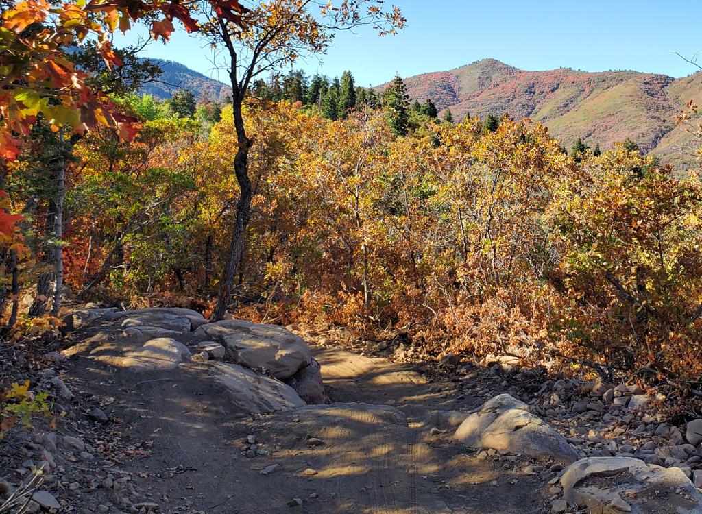
Looking south through oak and maple forest. Straight sections of the trail -- like this one -- are the exception.
The surrounding forest differs between the southern and
northern sides of the trail. On the southern side, it's mostly mature
gambel oak with stands of maple and an occasional fir. On the northern
half, there are areas of mature fir forest alternating with maple, oak,
and aspen. This northern side is significantly cooler -- and will stay wet
longer in the spring.
The shortest ride that includes all of Moose Tracks is a
loop from the Mule Ear trailhead. This includes the upper limb of Cutler's
Twist, a short piece of the doubletrack Bicentenial trail, then Moose
Tracks, southwestern Mule Ear down to Mule Ear Connector, and back north
to the trailhead. This loop is 6.8 miles with 900 vertical feet of overall
climbing.

Westbound through mixed forest near the ride's highest elevation.

Bruce rolls a turn on the downhill half of the trail.
A shorter and somewhat easier option is to use the northern limb of
Mule Ear to connect the trailhead directly to southern Moose Tracks --
when riding either direction. You'll skip 0.7 miles of Moose Tracks (and
the southern side of Mule Ear plus Mule Ear Connector). This route is 5
miles, a couple of miles shorter but it saves you around 150 feet of
climbing.
Many tougher riders pedal to Moose Tracks from the Main Gate
trailhead. This is a big ride, and can be combined with the loop around
Cutler Flats for a monster ride. Take 365 to Traily McTrailface and climb
to the southern side of Mule Ear. At this trail fork, you can keep
straight onto Mule Ear Connector for a counterclockwise loop, or turn left
onto Mule Ear to go clockwise.

Handlebar view as the ride passes through an aspen grove.

Looking west in the primitive parking at Mule Ear. The uphill trail is at the left side of the photo.
Mule Ear trailhead (recommended for intermediate and
beginning riders)From the southern North Fork (Ben Lomond trailhead) entry gate, drive
on the main North Fork Park gravel road northbound for 1.8 miles. Look for
the
trailhead sign on your right. Pull into the little loop and park. Connect to the trail on the northwest side of
the parking area. This path will take you back across the road to a trail
intersection with Mule Ear Connector. You can turn left and pedal to Mule
Ear, then left uphill to Moose Tracks for a clockwise loop. Or cross the
connector and head uphill on the northern limb of Mule Ear for 1/10th
mile, then right on Cutler's Twist for a counterclockwise ride.
You can also get to this trailhead from the northern (Cutler Flat)
entry to North Fork, but it's a little more complicated for a first-timer
to navigate.

South gate trailhead, looking at the entry to the 365 Trail.
365 (North Fork South Entry) TrailheadThe main trailhead for bikes is right at the south entry gate to North
Fork Park. See below for driving instructions. The gravel parking area is
to your left as you approach the park gates. Start on the 365
Trail, found on the southern side of parking at the kiosk. On 365,
climb past the entry to Spork. Fork to the left on
Traily Mctrailface and follow it to the intersection with Mule Ear. Turn
left to climb Mule Ear to Moose Tracks.
Specific Trail Information with sample loop ride
Mule Ear Connector (for simple loop option)

Looking south as we ride up and down on Mule Ear Connector.
This ride description is for a clockwise loop ride of Moose
Tracks that includes portions of Mule Ear Connector, Mule Ear, Bicentenial,
and Cutler's Twist. The total ride will be 6.8 miles with 900 vertical
feet of climbing. The loop can be done either direction.
Starting from the Mule Ear trailhead, pedal up across the gravel road
then quickly turn left onto Mule Ear Connector. Ride through oak and maple
forest southbound. There will be some up-and-down, but the general trend
is downhill as you lose 150 feet of elevation over the 0.9 miles.
Mule Ear southwest (uphill access or downhill continuation of flow at
southern end of Moose Tracks)

Early in the climb up the southern limb of Mule Ear, we're passing through maple forest. Here the maple leaves have already fallen by mid-October.
At mile 1.0 of the ride, you'll come to a 4-way trail
intersection. Mule Ear Connector ends here. Straight ahead is Traily
McTrailface (which would take you down to 365). Make a right turn onto
westbound Mule Ear. You're at the lowest elevation of the ride at 5850
feet.
Mule Ear will climb through scrub oak and maple forest.
There will be occasional breakout views. Some of these views will be the
best of the entire ride, so take a minute.
The sections of Mule Ear below Moose Tracks were rebuilt in 2024, so
the trail surface is smooth, non-technical, and wide. The riding is
suitable for beginning riders, assuming they're strong enough to tackle
the slope.

Looking southeast from Mule Ear as we ride through an area of low oak scrub.

Looking southwest from Mule Ear at the slopes of Ben Lomond.
After 0.8 miles of steady climbing on Mule Ear, you'll come
to a trail fork. To the right is Moose Tracks. You're now at mile 1.8 of
the loop ride at around 6200 feet elevation.
Moose Tracks (shown south to north)

Climbing uphill on a clockwise ride of Moose Tracks.
Moose Tracks is a highly-engineered bench-cut trail, new in
2024. Turns are generously banked and built well for either climbing or
descending. The trail surface is wide and non-technical, suitable for
unskilled riders.
On a clockwise ride, Moose Tracks will have you climbing for
another 2 miles, which will put you at mile 3.8 of the loop when you reach
the top. The
transition from climbing to descending occurs right after the set of
switchback turns where you pass the pelican on the post -- assuming it's
still there when you ride.

The fun pelican marker between sets of climbing turns. Almost to the top of the clockwise ride.

The trail twists and undulates. Never boring.
Moose Tracks now begins a steady descent for the next 2.3
miles before ending on the Bicentenial DT along Cutler Creek.
There are frequent optional stunts built into the trail. The
stunts are at trailside, off the main riding line, so they're easily
bypassed. Most stunts are of upper-intermediate difficulty, and can be
seen from far enough away that you can make up your mind in plenty of
time.

Bruce hits an optional rock drop.
 on the other side.")
This trailside stunt has a ramp up to a stump, with a small drop (which can be rolled) on the other side.

This ramp takes you up to a rock challenge where you'll bang down the downhill side.

This moose is hiding a calf behind her. She refused to budge until a couple of riders skidded to a panic stop coming the opposite direction.
Moose Tracks has its name for a reason. It's likely
that you'll encounter one of these big critters. Give them space and time
to clear the trail. Unlike deer, they usually stand their ground. And if a
moose wants to, it will stomp you into hamburger, which is especially
likely when there's a calf nearby.
I think the trail is equally nice in either direction, but
the experience is a bit different. Riders who are lucky enough to do it
both ways usually prefer the north-to-south direction. Cooler on the
climb, brighter sunlight on the downhill.

Bruce starts down the northern half of the trail.
 Moose Tracks from the Bicentenial doubletrack. The barrier is a temporary horse-extruder to prevent damage to the freshly built trail.")
Looking at the entry to (or exit from) Moose Tracks from the Bicentenial doubletrack. The barrier is a temporary horse-extruder to prevent damage to the freshly built trail.
The northern end of Moose Tracks is on the Cutler Creek
doubletrack portion of the Bicentenial Trail. If you're on the clockwise
loop, you're at mile 6.0. Turn right and pedal 0.3 miles to the pavilion
area. Keep to the right as the doubletracks fork, pass the entry to a
couple of narrow hiking trails, then find Cutler's Twist on your right.
Option: If you're in the mood for a bigger ride when you
reach the bottom of Moose Tracks,
consider adding the Long Loop. This will make your ride 12 miles and 1600
vertical. Go left on Bicentenial, crossing the creek to climb to the
western end of Long Loop. Stay on Long Loop to Traildemic then climb to
the pavilion area to connect to upper Cutler's Twist back to the
trailhead.

Cruising along an easy stretch of Moose Tracks.
Upper Cutler's Twist (return path)

Optional line while southbound on Cutler's Twist.
Southbound Cutler's Twist is found on the right side
of a gravel road, just past the toilet building. There will be 0.4 miles
of up-and-down singletrack in heavy forest. When you reach the northern
limb of Mule Ear, turn left downhill and coast back to the trailhead,
crossing Mule Ear Connector just before crossing the North Fork gravel
road.

Easy riding through tall fir trees near the ride's top elevation.
Bottom Line!Excellent trail, well-built, with a lot of fun features. Worth the trip
to North Fork no matter where you live.

North Fork Park area map
Getting there: Go up
Ogden Canyon. (From the north on I-15, take the 12th South Ogden exit and
head east on Highway 39. From the south, exit I-15 on US 89. Pass I-84 and
climb up the hill, then turn right on Harrison Blvd. Continue on Harrison
until you hit U-39 and turn R toward Ogden Canyon.) Turn left across the
dam at Pineview Reservoir. At the stop sign in Eden, turn left. Turn left
at the stop sign in Liberty. After about 1/4 mile, take the next right.
Just after you cross the river, veer left toward North Fork Park.
Main Gate trailhead: Turn left at the sign for Ben Lomond
trailhead. Drive to the North Fork Park south entry gate, but turn left
into a large gravel parking area
to your left as you approach the park gate. The 365 Trail is on the
southwest edge of parking at the kiosk. The Pipeline Trail is just up the
road from the entry gate outside the trailhead, on your right.
Mule Ear trailhead: Turn left
again at the North Fork Park sign. At the campground entry gate, you can
turn left into the 365 Trail trailhead for a longer ride. To park at the
Mule Loop trailhead, go
1.8 miles on the main North Fork Park road from where you turned off the main road. Look for a the
trailhead sign on your right. Pull into the little loop and park. Connect to the trail on the northwest side of
the parking area.
Road-fork (Cutler Flat) entry: Pass the
first entrance into the North Fork Park (on your left). Go another mile up
the road and turn left at the second entry N41 22.986 W111 54.298. Fork
left at the T intersection. When you reach a hairpin turn with a gate at
the apex (north side) of the turn, N41 22.979 W111 55.187, you're there. Take the singletrack that sneaks around the left side
of the gate, then climb the soft cindered DT up to the pavilion area where
there are connections to Bicentenial, Traildemic, and Cutler's Twist.
There's a trail to the right that's a shortcut to a Cutler Flat loop. Or
find the Mule Ear Connector to the west.