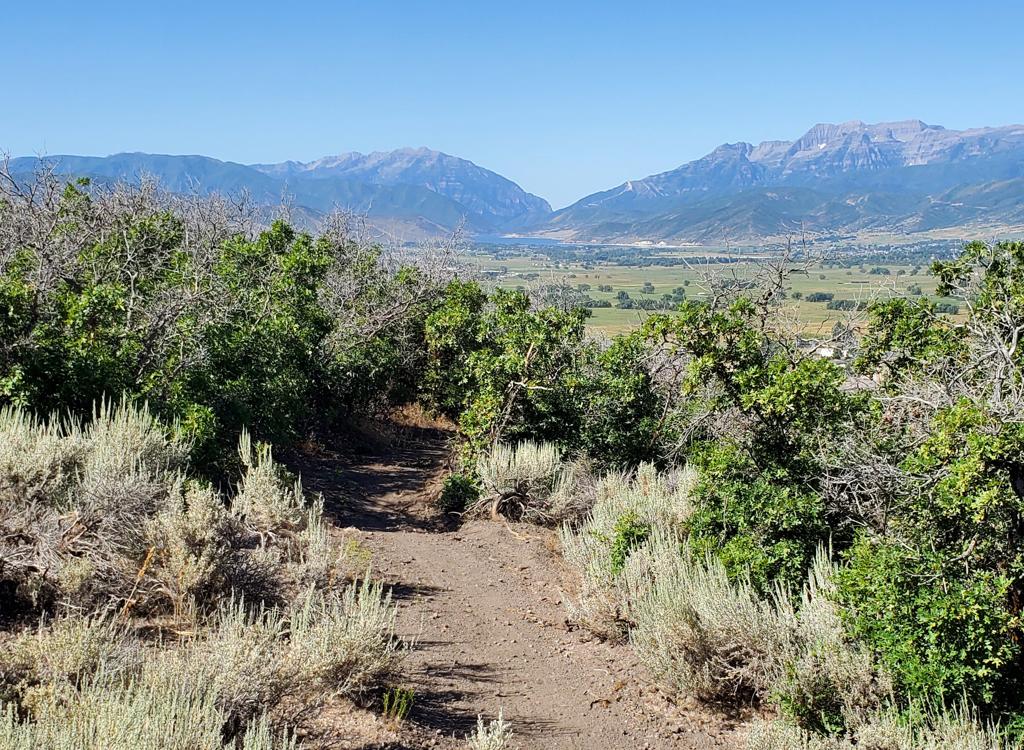
View from upper Rinse Cycle, looking east to Jordanelle. Trail review by Bruce on August 27, 2024.
Mayflower Area TrailsThe Mayflower trails lie within the Mayflower resort area, which is
still under construction at the time of this review. This area lies on a
generally east-facing slope above US Highway 40 just southeast of Park
City. The trails discussed here are newly open for riding in 2024 The plan is that the trail system will
expand further to the south as development continues. The old Spin Cycle trail, on the northern border of the riding area, is now
linked to the Mayflower trails.
In August 2024, the trails include We'll Go From There and
You Get It (connectors from parking to Rinse Cycle),
Spin
Cycle (expert DH trail, discussed in detail on another trail page),
Rinse Cycle (climbing route to Spin Cycle plus access to all area trails),
Humdinger aka Midmountain Connector (linking Rinse
Cycle to the Midmountain trail, with details on a separate trail page), Rory of the Mountain DH trail from Humdinger to Kaboom,
plus the Kaboom and Call Sign Casa loop off Rinse Cycle.

Climbing Rinse Cycle through mature oak and maple forest.

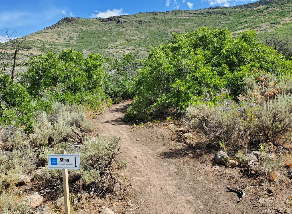
Sample trail sign at the Kaboom trail fork.
Trail signs are installed at the trail forks along Rinse Cycle. They're easy
to understand and well done -- and hopefully will be added to the other area
trails soon.
The Mayflower trails start at 6700 feet elevation at the trailheads just off
Deer Hollow Road west of US-40. The system ends at the Midmountain Extension at
around 8000 feet. See the Spin Cycle and Humdinger trail pages for
more details.
The expected riding season for these trails will be late
June through early October. Resort activity (preparing for the upcoming
ski season) will usually close these trails in the fall, at a time when
trails at similar elevations are still open for riding.

There are recurring views of Jordanelle. This view is from Call Sign Casa on the lower elevation of the slope.

Trails -- except for Spin Cycle -- are machined bench cuts with easy slopes.
Most of the trails in the area are suitable for beginning
riders, although a climb through the system uphill to the Midmountain
trail is more work than most early riders can handle. The Spin Cycle trail
is an expert one-way DH route, and the new Rory of the Mountain DH from Humdinger to Kaboom would be considered intermediate.
Trailheads and Connections

Looking west to the trail from parking.
Deer Crest (We'll Go From There) Trailhead
The Deer Crest Trailhead is located at the uphill corner of a
three-section parking lot just off Deer Hollow Road. (This route is
heavily impacted by construction in 2024. The directions here take you
around a closed section of Deer Hollow Road.) Exit US-40 at Mayflower.
Turn east toward the reservoir, then left on Jordanelle Parkway. Turn left
under US-40 onto Mayflower Mine Road. Veer left to go south. Turn right to
head uphill on Deer Hollow Road, then left again to pass between two large
buildings. Now work your way uphill to the far corner of the parking
area, where you'll see the kiosk. Head uphill to start your ride on the
We'll Go From There trail.

The trail entry is between the two vehicles. We're looking west.
Mayflower (You Get It) Trailhead
Drive to Deer Hollow Road as above, but continue uphill past the large
buildings for another 100 yards. Turn to the left into a large parking
area. Head toward the little wood-and-glass kiosk. Find a trail that heads
away from parking. Keep to the right and uphill as the "We'll Go From
There" joins.

Easy riding on the Midmountain Connector trail en route to the Mayflower trails.
Via Humdinger from Midmountain
In Park City, follow the signs
toward Deer Valley Resort. To get to the upper (Silver Lake) lodge, turn left on Royal Drive just
after the road divides -- before you actually see the Snow Park (lower)
lodge.
Drive 4 miles uphill, following the signs to the Silver Lake lodge. (I
recommend parking at the lower lodge and taking the city shuttle bus
uphill instead of driving to the upper lodge.) Once
you're at the lift area, face the mountain and look around for trail
signs. The northbound Midmountain Trail is to your right, coasting downhill to the
underpass then left onto singletrack. The Midmountain Extension is to your
left, beginning as a doubletrack. It will be 0.9 miles to the Humdinger (aka Midmountain Connector) trail, which descends 2.1 miles to the Rory of the Mountain DH trail before
climbing to the Rinse Cycle trail at mile 3.3 from Midmountain.

Heading south on Rinse Cycle after climbing up You Get It.
Rinse Cycle is the key to all the Mayflower area trails.
It's 2.7 miles long, extending from the bottom of Spin Cycle to the top of
Spin Cycle, with connections to other area trails along the way. It's an
easier-intermediate route for climbing or descending.
Rinse Cycle is the obvious climbing route for doing laps down the
expert DH Spin Cycle.
At mile 0.2 from the bottom of Spin Cycle, Rinse Cycle is
joined by the You Get It trail from the trailhead parking lots.
If you started at these parking areas near US-40, you'll climb You Get
It for 0.4 miles (and just over 150 vertical feet) to reach this trail
fork. Turn to the left on Rinse Cycle.

Typical view on Rinse Cycle as the trail meanders through maple forest.

Trail fork with Call Sign Base. Note the nice trail sign.
At mile 0.2 from You Get It (0.4 from the bottom of Spin
Cycle), there's a trail fork with Call Sign Base (see below). Keep to the
right to continue your climb on Rinse Cycle.
As you continue uphill, the terrain will gradually change
from oak and maple forest to aspen, chokecherry, and occasional fir. Then
it will change back to gambel oak on the more sun-exposed slopes.
The trail will pass back and forth over a ski slope multiple times. The
ski route is just dirt and rocks in summer 2024.

Heading into a turn descending Rinse Cycle. This is a two-way trail.

Looking from Kaboom as Rinse Cycle makes a hard turn at the trail fork.
Rinse Cycle is a bench-cut on smooth dirt. It zig-zags
across the hillside with fairly tight turns between the traverses. While
the turns are banked, they're not designed for high-speed downhill
riding.
At mile 1.0 from You Get It (1.4 from trailhead parking), turn hard
right to continue climbing. The trail to the left is Kaboom (see below)
After 2 miles from the trailhead connector fork, you'll
reach the Midmountain Connector trail. The Connector is on your left at
the apex of a right-hand turn of Rinse Cycle. If you find yourself going
downhill here, you're NOT headed for the top of Spin Cycle.
Riders coming from the Midmountain trail will turn onto Rinse Cycle
here, either for an intermediate-level descent on Rinse Cycle or an expert
DH after climbing up to Spin Cycle.

Making the last bit of climb after passing Humdinger (the Midmountain Connector).

At the top of Rinse Cycle looking east.
Rinse Cycle climbs another half-mile uphill. You'll reach a
small metal gate in an area of open scrub near a ridgeline. To your right,
Spin Cycle forks steeply downhill. If you continue straight for another
100 yards, you'll reach a small subdivision road. To connect through to
other area trails (such as Outlook or Deer Crest), you'd need to pick your
way through private streets -- which a lot of locals do.

Looking down the beginning of Spin Cycle from the Rinse Cycle trail.
Spin Cycle is an expert-level DH ride from the top of Rinse
Cycle. As it reaches its lowest elevation, it becomes Rinse Cycle for the
return back to the trailhead connector trail You Get It.
Spin Cycle is an older trail, very popular with the locals. It used to
be hard to find and required a complex road-and-dirt uphill return route.
Now with Rinse Cycle as the climbing route, Spin Cycle is easy to
navigate. See the Spin Cycle trail page for
more information!
Spin Cycle is 1.6 miles long, descending 800 vertical feet.
Compare this to Rinse Cycle, which takes 2.7 miles to cover the same
elevation change.
Spin Cycle is an old-fashioned, straight-forward ravine plunge. Last
time I rode it, there were no tables, jumps or tricks engineered into it.
Just whooshing back and forth from sidewall to creek to sidewall and back
again.

Twisty trail in the trees as Straz flies down Spin Cycle. Photo by Phillymike.

A deluxe ravine crossing.
At first, you'll cross the ravine on dirt -- and occasional
rocks and erosion ruts. As you get lower in the ride, there will
occasionally be wooden bridges over the bottom of the ravine.
When the trail seems to flatten and you pass a small metal
gate, you've completed Spin Cycle and you're entering Rinse Cycle. The
trailhead connection via You Got It is 0.2 miles away on Rinse Cycle.
Another loop up Rinse Cycle and down Spin Cycle is 4.3 miles and 800
vertical.

The spot where old Spin Cycle diverts to become the new Rinse Cycle.
Humdinger (Midmountain Connector)
Looking through the fir forest on upper Midmountain Connector.
The Humdinger (aka Midmountain Connector) trail joins upper Rinse Cycle to
the Midmountain Extension trail east of Deer Valley. This trail is 3.3
miles long, with 250 feet of descending followed by 800 feet of climbing
when ridden from Rinse Cycle.
The Humdinger trail ends at just under 8000 feet elevation. It often
traverses north-facing slopes in deep forest. So it usually won't be ready
for riding until very late June or early July.
The Connector trail will link to additional trails as the
Mayflower system is further developed. At this time, there's an
intermediate-level DH ride "Rory of the Mountains" that forks away at mile 1.2 from Rinse Cycle.
See the Humdinger (Midmountain Connector) trail page
for full details on this trail.

Looking toward Jordanelle from the Connector, near the lowest elevation on the trail.

Call Sign Casa is an easy ride. We're heading north through mature forest.
Call Sign Casa forks to the left from Rinse Cycle at mile
0.2 from You Get It. This trail can be your return route from Kaboom (see
below), or a your path to go further east and downhill to civilization. It
begins at 6900 feet elevation.
If your intention is to ride the Kaboom loop, I'd stay to the right on
Rinse Cycle at this trail fork. Then you'll ride Call Sign Casa back to
this spot as you return from Kaboom.
From Rinse Cycle, Call Sign Casa angles downhill through a
couple of turns before traversing to the south.
At mile 0.4 from Rinse Cycle, there's a trail fork where (I presume)
Call Sign Casa heads downhill to the left. The route was posted closed on
the day of my ride -- and I could hear monstrous construction activity
including a helicopter -- so I haven't added that route to this review
page.

Looking east as the trail traverses southbound.

Approaching a downhill turn on Call Sign Casa.
So for now, the trail fork with Kaboom is the end of Call
Sign Casa.
Most riders will use Call Sign Casa in the south to north direction, as
a return path from Kaboom to lower Rinse Cycle.

On Kaboom looking toward the trail fork with Rinse Cycle. Uphill is on the left, downhill on the right.
Kaboom is an easier-intermediate trail that's usually done
as a counterclockwise loop from the middle of the Rinse Cycle trail back
to lower Rinse Cycle (via Call Sign Casa).
The upper end of Kaboom is reached on Rinse Cycle, 1.2 miles from the
You Got It trailhead fork.
Kaboom is 0.7 miles long. When added to 0.4 miles of Call
Sign Casa plus 0.8 miles of Rinse Cycle between Call Sign Casa and upper
Kaboom, the loop is about 2 miles long with 250 feet of elevation change.
This makes a nice "extra credit" loop-de-loop while heading
uphill on Rinse Cycle.
 to the south.")
Upper Kaboom is the trail to the left. The right-hand trail connects to a doubletrack (and the bottom of an intermediate DH) to the south.

Crossing a future ski slope.
Around 100 yards after upper Kaboom forks away from Rinse
Cycle, you'll reach a trail fork (unmarked as of August 2024). The trail
to the left is Kaboom. The right is a connector from the bottom of the
intermediate DH Rory of the Mountain (see below).
At mile 0.7 from Rinse Cycle, you'll join Call Sign Casa heading north.
The trail that goes downhill to the right was marked "closed" on
the day of my mapping ride. Based on the area trail plan, it heads
southeast and downhill to the edge of the buildings.

Heading west toward a doubletrack at the bottom of the canyon.
The trail that I'm calling "Kaboom Connector" ties
the bottom of the Rory of the Mountain intermediate-level DH route -- which originates on Humdinger
-- to upper Kaboom. It's 0.4 miles long with very
little elevation change, angling slightly uphill as you ride from Rory of the Mountain's lowest point to Kaboom.
The information on this page will evolve as the trail system matures.
On the southern end, the trail begins on a doubletrack, 100
feet downhill from the bottom of the DH trail. It runs to the top of a
ridge -- with the faintest trace of uphill slope -- before joining Kaboom
just 100 yards from Rinse Cycle.

Crossing a couple of tiny creek branches before hitting the doubletrack.
Rory of the Mountain (Intermediate DH)

Approaching a highly-banked turn on brand-new trail, looking south.
This trail seems open for riding, but had no designated name
or trail markers in late August 2024. The "Rory of the Mountain" name is based on a subsequent label on Trailforks.
The trail begins on Humdinger (aka the Midmountain Connector), 1.2 miles from Rinse
Cycle or 2.1 miles downhill from Midmountain. When combined with a short
connector to Kaboom, the ride would be 1.3 miles -- plus the miles
involved in whatever route you took to the top.
On the uphill end, the trail begins at a wide spot on Midmountain
Connector, where a "stand and get ready" spot has been created
on the uphill side. After 0.9 miles, the singletrack dumps onto an old
doubletrack. Keep to the right and go downhill around 100 feet to find a
connector trail that climbs gently to upper Kaboom.

Origin of the trail on Humdinger (Midmountain Connector).

In general, the trail is highly forested.
There are highly-banked turns that seem designed for speed.
While I was able to climb the trail from the ravine doubletrack up to the
Midmountain Connector, it seems clearly designed to be done downhill.
Getting there, Midmountain Extension at Deer Valley
In Park City, follow the signs
toward Deer Valley Resort. To get to the upper (Silver Lake) lodge, turn left on Royal Drive just
after the road divides -- before you actually see the Snow Park lodge.
Drive 4 miles uphill, following the signs. Note that in 2017 the previous
parking lot no longer exists, being replaced by a new building. So on
weekends your chance of finding a parking spot aren't good. You can park
at the lower Snow Park lodge and take the city shuttle bus uphill. Once
you're at the lift area, face the mountain. Your
ride on the Midmountain Extension will start by turning left and riding east.
Deer Crest (We'll Go From There) Trailhead
The Deer Crest Trailhead is located at the uphill corner of a three-section
parking lot just off Deer Hollow Road. (This route is heavily impacted by
construction in 2024. The directions here take you around a closed section of
Deer Hollow Road.) Exit US-40 at Mayflower. Turn east toward the reservoir, then
left on Jordanelle Parkway. Turn left under US-40 onto Mayflower Mine Road. Veer
left to go south. Turn right to head uphill on Deer Hollow Road, then left again
to pass between two large buildings. Now work your way to the right uphill to the far
corner of the parking area, where you'll see the kiosk. Head uphill to start
your ride on the We'll Go From There trail.
Mayflower (You Get It) Trailhead
Drive to Deer Hollow Road as above, but continue uphill past the large buildings
for another 100 yards. Turn to the left into a large parking area. Head toward
the little wood-and-glass kiosk. Find a trail that heads away from parking. Keep
to the right and uphill as the "We'll Go From There" joins.